
  Maps partly based on data from the SA Weather Service
WEDNESDAY WEATHER: Thunderstorm warnings for seven provinces and damaging coastal winds in the westBy Staff WriterPublished: 23 December 2025 [updated 24 December] This forecast is for: Wed 24 December 2025 The maps cover: Wed 24 Dec – Wed 24 Dec
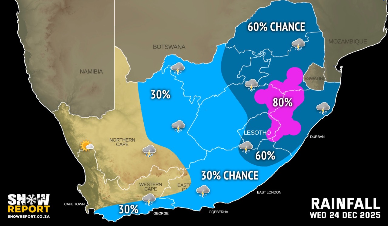
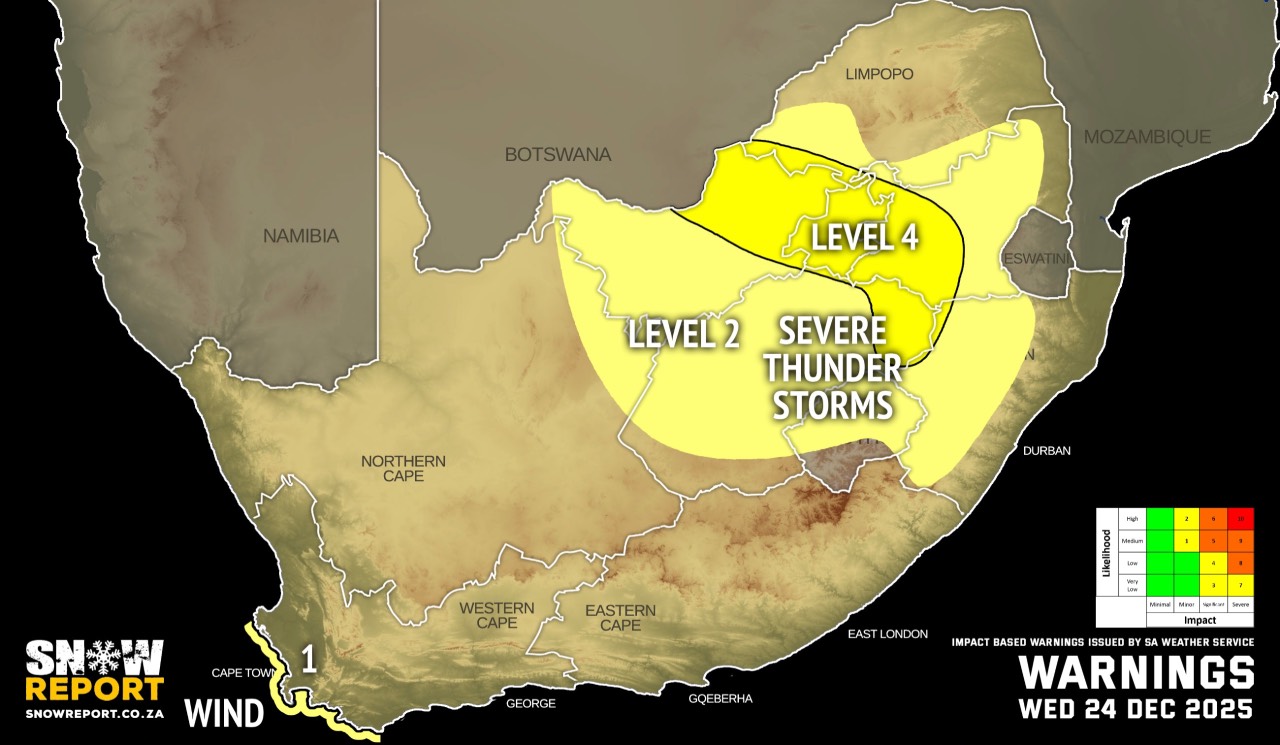
The latest forecast is available by clicking here. Partly cloudy and warm to cool with isolated to scattered showers and thundershowers possible from the afternoon on Wednesday. Morning fog can be expected along the west coast and parts of Mpumalanga. Warnings from the SA Weather Service for Wednesday: A. level 4 warning for severe thunderstorms over parts of North West, Mpumalanga, the Free State and the whole of Gauteng. B. level 2 warning for severe thunderstorms over parts of the Northern Cape, North West, the Free State, KwaZulu-Natal, Mpumalanga and Limpopo. C. level 1 warning for damaging coastal winds resulting in localised disruption of small harbours and/or port for a short period of time and difficulty in navigation at sea between Saldanha Bay and Cape Agulhas. Extremely high fire danger conditions are expected over the Matzikama Local Municipality in the Western Cape. Regional forecasts from the SA Weather Service for Wednesday: GAUTENG Cloudy and warm with scattered showers and thundershowers. MPUMALANGA Morning fog patches over the highveld and escarpment, otherwise cloudy and cool to warm with scattered showers and thundershowers. LIMPOPO Cloudy and cool to warm with scattered showers and thundershowers. NORTH-WEST Cloudy and warm with scattered showers and thundershowers, but isolated in the west. THE FREE STATE Cloudy and warm with scattered showers and thundershowers, but isolated in the west. THE NORTHERN CAPE Morning fog along the coast, otherwise partly cloudy and warm to hot with isolated showers and thundershowers, except in the west where it will be fine. The wind along the coast will be moderate to fresh southerly to south-westerly. THE WESTERN CAPE Morning fog along the west coast, otherwise partly cloudy and cool to warm with isolated showers and rain in the south. It will be hot to very hot in the north-west. The wind along the coast will be moderate to fresh south-westerly in the west, otherwise south to south-easterly, becoming strong along the south-west from the afternoon. THE WESTERN HALF OF THE EASTERN CAPE Partly cloudy in the north-west, otherwise cloudy and cool, with isolated showers and rain. The wind along the coast will be moderate south-westerly becoming moderate south-easterly from late morning. THE EASTERN HALF OF THE EASTERN CAPE Cloudy and cool, with isolated showers and rain, but scattered in the far east. The wind along the coast will be moderate south-westerly becoming moderate south-easterly in the afternoon. KWAZULU-NATAL Cloudy and cool to warm with scattered showers and thundershowers. The wind along the coast will be light northerly to north-westerly north of Richard's Bay at first, otherwise moderate to fresh southerly to south-westerly spreading to Kosi Bay by afternoon. Travellers forecasts from the SA Weather Service for Wednesday: PRETORIA Cloudy with scattered showers and thundershowers. Minimum/Maximum: 17/27°C JOHANNESBURG Cloudy with scattered showers and thundershowers. Minimum/Maximum: 16/26°C VEREENIGING Cloudy with scattered showers and thundershowers. Minimum/Maximum: 16/27°C MBOMBELA Morning fog patches, otherwise cloudy with scattered showers and thundershowers. Minimum/Maximum: 18/26°C POLOKWANE Cloudy with scattered showers and thundershowers. Minimum/Maximum: 17/26°C MAHIKENG Cloudy with scattered showers and thundershowers. Minimum/Maximum: 17/29°C VRYBURG Cloudy with isolated showers and thundershowers. Minimum/Maximum: 18/30°C BLOEMFONTEIN Cloudy with isolated showers and thundershowers. Minimum/Maximum: 16/30°C KIMBERLEY Partly cloudy with isolated showers and thundershowers. Minimum/Maximum: 18/31°C UPINGTON Partly cloudy. Minimum/Maximum: 20/35°C CAPE TOWN Partly cloudy morning otherwise fine. Wind: Moderate to fresh south-easterly, becoming strong to near gale by the afternoon. Minimum/Maximum: 18/29°C GEORGE Partly cloudy with light rain from late morning. Wind: Moderate south-westerly becoming fresh by the afternoon. Minimum/Maximum: 17/22°C GQEBERHA Cloudy with isolated showers and rain. Wind: Moderate south-westerly becoming moderate south-easterly from late morning. Minimum/Maximum: 18/22°C EAST LONDON Cloudy with isolated showers and rain. Wind: Moderate south-westerly becoming moderate south-easterly in the afternoon. Minimum/Maximum: 20/21°C DURBAN Cloudy with scattered showers and thundershowers. Wind: Moderate to fresh southerly to south-westerly. Minimum/Maximum: 20/24°C The expected UVB Sunburn Index: Low RICHARDS BAY Cloudy with scattered showers and thundershowers. Wind: Light northerly at first, otherwise moderate to fresh southerly to south-westerly. Minimum/Maximum: 20/25°C PIETERMARITZBURG Cloudy with scattered showers and thundershowers. Minimum/Maximum: 16/22°C This forecast is usually updated a few times per day.
Please be sure to send photos and videos to us via whatsapp and also tell us where and when they were taken. Follow our channels
|