
MONDAY WEATHER: Widespread rain in the east and severe thunderstorms for seven provinces
By Staff WriterPublished: 22 March 2026
This forecast is for: Mon 23 March 2026
The maps cover: Mon 23 Mar – Mon 23 Mar
| SHARE TO |
The latest forecast is available by clicking here.
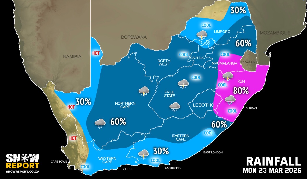
Very hot conditions are expected in places over the Namakwa District of the Northern Cape on Monday persisting into Tuesday, when it will include the West Coast district, the Cape Winelands, Cape Metropole, and Overberg local municipalities of the Western Cape.
Fog can be expected in a number of areas on Monday.
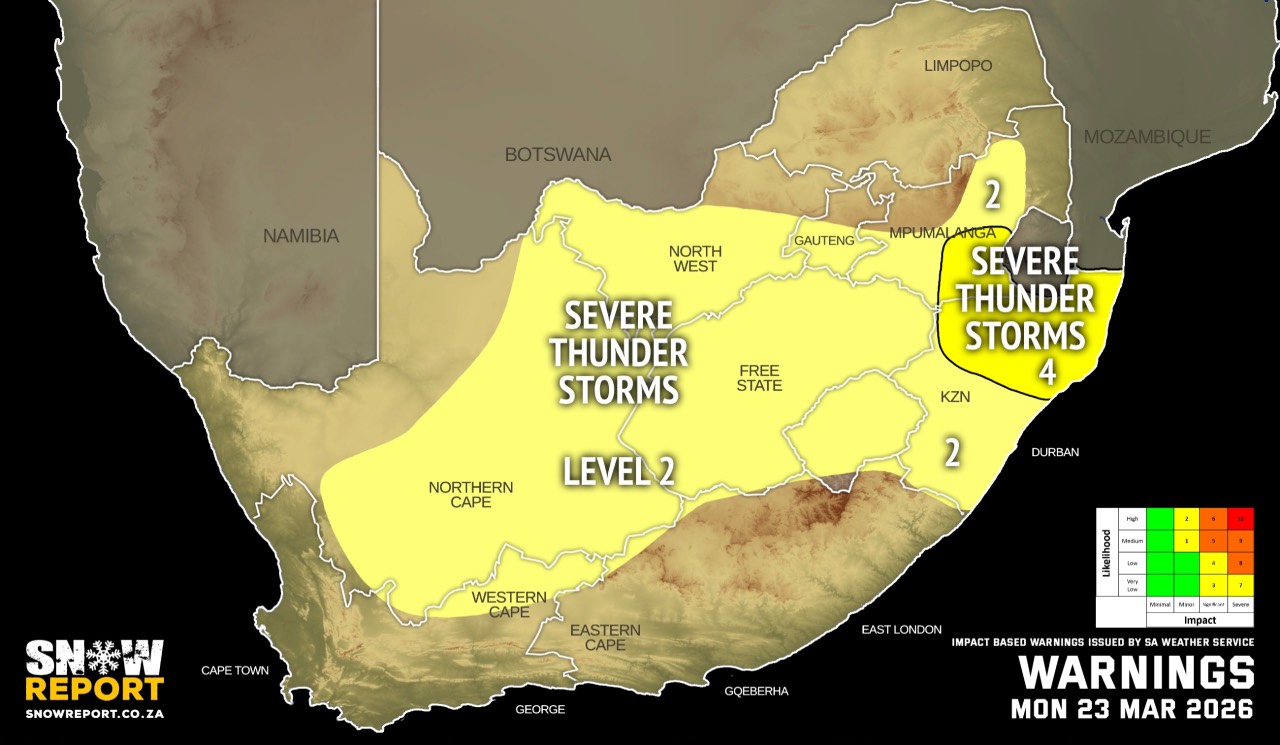
Warnings from the SA Weather Service for Monday:
A. level 4 warning for severe thunderstorms associated with heavy downpours that may result in flooding of susceptible low-lying bridges and roads, as well as damages to infrastructure and settlements, due to strong gusty winds, are expected over the south-eastern parts of Mpumalanga, northern parts of KwaZulu-Natal.
B. level 2 warning for severe thunderstorms associated with heavy downpours that may result in localised flooding of susceptible low-lying bridges and roads, as well as damages to infrastructure and settlements due to strong gusty winds, are expected over the southern parts of Gauteng, southern parts and escarpment areas of Mpumalanga, southern parts of KwaZulu-Natal, central and eastern parts of the Northern Cape, Free State, as well as vast parts of the North West.
Extremely high fire danger conditions are expected over the Kai !Garib Municipality of the Northern Cape.
Regional forecasts from the SA Weather Service for Monday:
GAUTENG
Morning fog patches in the extreme south-east, otherwise cloudy and cool to warm with scattered showers and thundershowers, but isolated in the extreme north.
MPUMALANGA
Early morning fog patches on the Highveld and escarpment areas, otherwise cloudy and cool to warm with scattered showers and thundershowers but widespread in the south-east.
LIMPOPO
Cloudy at first with early morning fog patches on the escarpment areas, otherwise partly cloudy and warm with isolated showers and thundershowers (except for the north-west) but scattered in the extreme south-east.
NORTH-WEST
Cloudy and cool to warm, with scattered showers and thundershowers.
THE FREE STATE
Cloudy and cool to warm, with scattered showers and thundershowers.
THE NORTHERN CAPE
Cloudy in the west in the morning where it will become fine and very hot, otherwise partly cloudy and warm to hot. Isolated to scattered showers and thundershowers are expected over the eastern and central parts from the afternoon. The wind along the coast will be moderate to fresh southerly.
THE WESTERN CAPE
Cloudy over the southern parts with morning light rain, otherwise partly cloudy and cool to warm but hot to very hot in places over the western parts where it will be fine. Isolated to scattered showers and thundershowers are expected over the north-eastern parts from the afternoon. The wind along the coast will be moderate southerly to south-easterly becoming fresh to strong from the afternoon.
THE WESTERN HALF OF THE EASTERN CAPE
Cloudy with fog in places in the morning, otherwise fine and cool, becoming partly cloudy with isolated showers and thundershowers in the afternoon. The wind along the coast will be light south-westerly, becoming moderate to fresh easterly.
THE EASTERN HALF OF THE EASTERN CAPE
Cloudy with fog in places in the morning, otherwise fine and cool becoming partly cloudy with scattered showers and thundershowers, but isolated along the coast and adjacent interior. The wind along the coast will be light to moderate south-westerly in the morning, otherwise south-easterly, becoming easterly by evening.
KWAZULU-NATAL
Morning fog over the interior, otherwise partly cloudy and warm but hot in the north-east. It will become cloudy in the afternoon with widespread showers and thundershowers. The wind along the coast will be light to moderate north-easterly, becoming moderate to fresh southwesterly to southerly in the south from mid-morning, spreading northwards in the afternoon.
Travellers forecasts from the SA Weather Service for Monday:
PRETORIA
Cloudy with scattered showers and thundershowers.
Minimum/Maximum: 18/26°C
JOHANNESBURG
Cloudy with scattered showers and thundershowers.
Minimum/Maximum: 16/24°C
VEREENIGING
Cloudy with scattered showers and thundershowers.
Minimum/Maximum: 17/26°C
MBOMBELA
Cloudy with scattered showers and thundershowers.
Minimum/Maximum: 19/30°C
POLOKWANE
Cloudy with isolated showers and thundershowers.
Minimum/Maximum: 19/28°C
MAHIKENG
Cloudy with scattered showers and thundershowers.
Minimum/Maximum: 17/22°C
VRYBURG
Cloudy with scattered showers and thundershowers.
Minimum/Maximum: 17/25°C
BLOEMFONTEIN
Cloudy with scattered showers and thundershowers.
Minimum/Maximum: 16/26°C
KIMBERLEY
Cloudy with scattered showers and thundershowers.
Minimum/Maximum: 17/29°C
UPINGTON
Partly cloudy with isolated showers and thundershowers.
Minimum/Maximum: 22/34°C
CAPE TOWN
Fine.
Wind: Light to moderate southerly to south-easterly.
Minimum/Maximum: 17/30°C
GEORGE
Cloudy with morning light rain, becoming partly cloudy from the late afternoon.
Wind: Light and variable, becoming moderate south-easterly from the afternoon.
Minimum/Maximum: 15/23°C
GQEBERHA
Cloudy with isolated showers and rain.
Wind: Light south-westerly, becoming moderate to fresh easterly.
Minimum/Maximum: 15/24°C
EAST LONDON
Cloudy with isolated showers and rain.
Wind: Light to moderate south-westerly in the morning, otherwise south-easterly becoming easterly by evening.
Minimum/Maximum: 18/23°C
DURBAN
Cloudy with widespread showers and thundershowers.
Wind: Moderate to fresh southerly to south-westerly, becoming easterly to north-easterly in the afternoon.
Minimum/Maximum: 23/28°C
RICHARDS BAY
Cloudy with widespread showers and thundershowers.
Wind: Moderate to fresh southerly to south-westerly, becoming easterly to north-easterly in the afternoon.
Minimum/Maximum: 22/30°C
PIETERMARITZBURG
Morning fog, otherwise cloudy with widespread showers and thundershowers.
Minimum/Maximum: 18/28°C
This forecast is usually updated a few times per day.
| SHARE TO |
Please be sure to send photos and videos to us via whatsapp and also tell us where and when they were taken.
Follow our channels