
   Swipe left or right for more maps, and see below for others
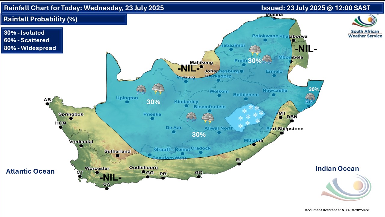
A disruptive rainfall warning for KwaZulu-Natal on Wednesday and widespread fogBy Staff WriterPublished: 22 July 2025 [updated 23 July] This forecast is for: Wed 23 July 2025 The maps cover: Wed 23 Jul – Fri 25 Jul
A newer forecast is available by clicking here. You can listen to this daily weather forecast as a 4 minute podcast by pressing the > play button above. Cloudy and cold to cool conditions, with isolated showers and thundershowers over the many parts of the country on Wednesday, according to the SA Weather Service. From Thursday it should be partly cloudy and cold to cool, with isolated showers and thundershowers over the central and eastern parts of the country. Warnings from the SA Weather Service for Wednesday: A. level 2 warning for disruptive rainfall resulting in localised flooding of susceptible formal/informal settlements or roads, low lying areas and/or bridges, slippery roads leading to minor vehicle accidents, and difficulty in driving conditions on dirt roads along the north coast of KwaZulu-Natal. Regional forecasts from the SA Weather Service for Wednesday: 1. GAUTENG Morning fog patches in the south and central, otherwise partly cloudy and cold but cool in the north. The expected UVB sunburn index: High 2. MPUMALANGA Morning fog patches along the escarpment, otherwise Partly cloudy and cold but cool in places in the east with isolated showers except in the extreme west. 3. LIMPOPO Morning fog patches along the escarpment, otherwise partly cloudy and cool with isolated showers in the east where it will be cool. 4. NORTH-WEST PROVINCE Partly cloudy and cool, with isolated showers and thundershowers over the western parts. 5. FREE STATE Cloudy with morning fog patches over the eastern parts at first, otherwise partly cloudy and cold to cool, with isolated showers and thundershowers except over the northern parts. 6. NORTHERN CAPE Cloudy with morning fog along the northern parts of the coast, otherwise partly cloudy and cool to warm with isolated showers and thundershowers in the east and central in the afternoon. The wind along the coast will be moderate to fresh south-easterly. 7. WESTERN CAPE Partly cloudy with morning mist or fog patches over the northern and south-western parts, otherwise fine and cool to warm. Isolated showers and thundershowers are expected over the extreme north-eastern parts in the afternoon. The wind along the coast will be moderate to fresh southerly to south-easterly, but light to moderate north-easterly along the south coast in the morning. The expected UVB sunburn index: Low 8. WESTERN HALF OF THE EASTERN CAPE Morning fog in places over the interior, otherwise fine and cool, becoming partly cloudy with isolated afternoon thundershowers in the north. The wind along the coast will be light north-easterly, becoming south-westerly by afternoon. 9. EASTERN HALF OF THE EASTERN CAPE Morning fog in places over the interior, otherwise fine and cool, becoming partly cloudy with isolated afternoon thundershowers in the north. The wind along the coast will be light to moderate north-easterly. 10. KWAZULU-NATAL Morning fog in places over the interior, otherwise partly cloudy and cool but cold in places in the west. Isolated showers and rain are expected but scattered along the north coast. The wind along the coast will be moderate to fresh southerly to south-westerly but north-easterly in the extreme south, spreading to Richards Bay by late afternoon. It will become south-easterly in the north from late morning. The expected UVB sunburn index: Low Travellers forecasts from the SA Weather Service for Wednesday: PRETORIA Partly cloudy. Minimum/Maximum: 06/18°C The expected UVB Sunburn Index: High JOHANNESBURG Morning fog patches, otherwise, partly cloudy. Minimum/Maximum: 06/18°C VEREENIGING Morning fog patches, otherwise, partly cloudy. Minimum/Maximum: 04/17°C MBOMBELA Morning fog patches, otherwise, partly cloudy with isolated showers by the afternoon. Minimum/Maximum: 11/20°C POLOKWANE Morning fog patches, otherwise, partly cloudy with isolated showers by the afternoon. Minimum/Maximum: 09/17°C MAHIKENG Partly cloudy. Minimum/Maximum: 07/19°C VRYBURG Partly cloudy with isolated showers and thundershowers by the afternoon. Minimum/Maximum: 07/19°C BLOEMFONTEIN Partly cloudy with isolated showers and thundershowers by the afternoon. Minimum/Maximum: 06/18°C KIMBERLEY Partly cloudy with isolated showers and thundershowers by the afternoon. Minimum/Maximum: 08/20°C UPINGTON Partly cloudy with isolated showers and thundershowers by the afternoon. Minimum/Maximum: 09/23°C CAPE TOWN Fine Wind: Light to moderate south-easterly. Minimum/Maximum: 10/21°C The expected UVB Sunburn Index: Low GEORGE Partly cloudy in the morning, otherwise fine. Wind: Light to moderate north-easterly, becoming moderate to fresh easterly to south-easterly in the afternoon. Minimum/Maximum: 07/20°C GQEBERHA Fine. Wind: Light to moderate north-easterly, becoming south-westerly in the evening. Minimum/Maximum: 09/21°C EAST LONDON Fine. Wind: Light to moderate north-easterly. Minimum/Maximum: 13/22°C DURBAN Partly cloudy with isolated showers and rain. Wind: Moderate to fresh southerly to south-westerly until early morning, otherwise, light north-easterly from the afternoon. Minimum/Maximum: 15/20°C The expected UVB Sunburn Index: Low RICHARDS BAY Partly cloudy with scattered showers and rain. Wind: Light to moderate south-westerly until midday, otherwise light south-easterly, becoming light and variable from the evening. Minimum/Maximum: 15/20°C PIETERMARITZBURG Morning fog patches, otherwise, partly cloudy with isolated showers and rain. Minimum/Maximum: 08/18°C This forecast is usually updated a few times per day.
Please be sure to send photos and videos to us via whatsapp and also tell us where and when they were taken. Follow our channels
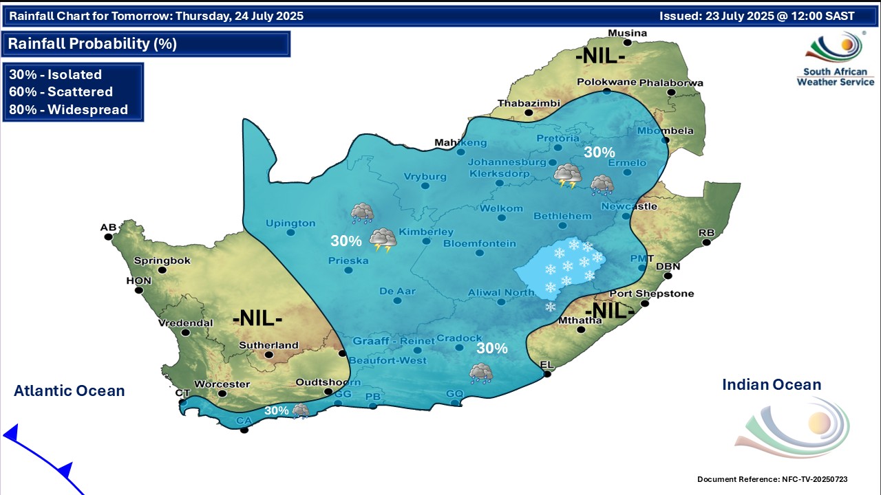
Maps for Thursday 24 July
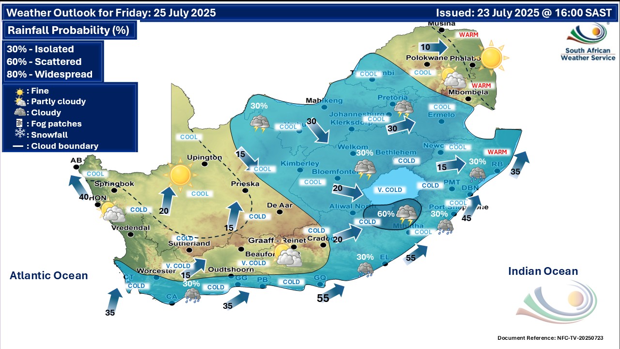
 Maps for Friday 25 July
|