
MONDAY WEATHER: Widespread rainfall and a LEVEL 5 warning with possible flooding due to a cut-off low
By Staff WriterPublished: 22 February 2026 [updated 23 February]
This forecast is for: Mon 23 February 2026
The maps cover: Mon 23 Feb – Mon 23 Feb
| SHARE TO |
The latest forecast is available by clicking here.
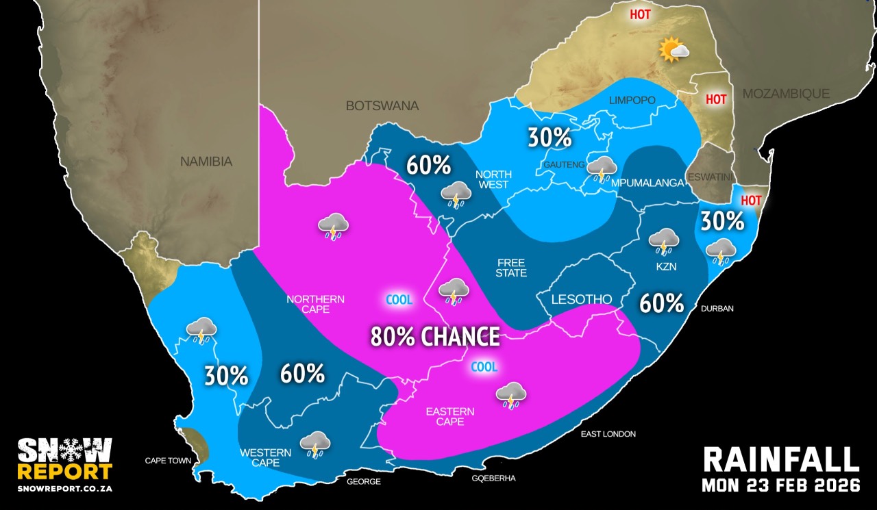
A cut-off low pressure system is expected over the western parts of the country and could result in heavy rain in places over parts of the country.
The cut-off low is expected to affect the Western Cape from Sunday until Tuesday morning. Models indicate daily rainfall accumulations of 15-35mm over much of the province during this period, with higher totals of 45-55mm are possible over parts of the Central and Little Karoo on Sunday and Monday according to the SA Weather Service.
Significantly higher accumulations of 100-155mm between Knysna and Plettenberg Bay are however possible as the system exits the province on Tuesday.
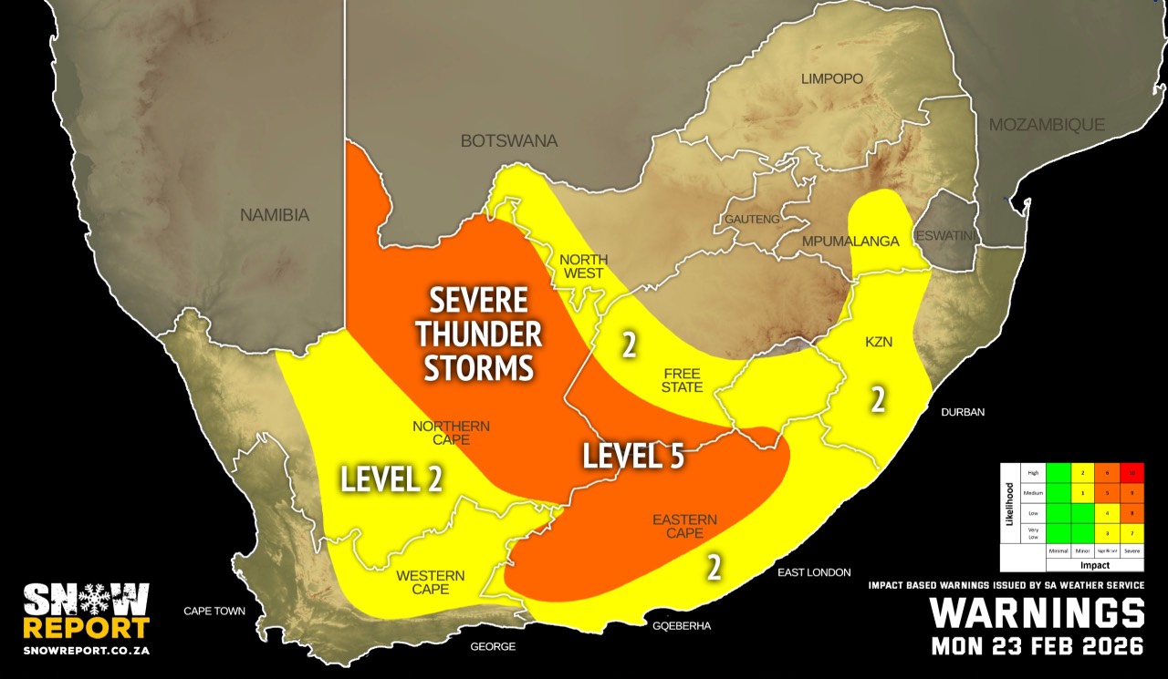
Warnings from the SA Weather Service for Monday:
A. level 5 warning for severe thunderstorms with heavy downpours that will result in flooding of susceptible roads and low-lying bridges/areas, damaging winds, excessive lightning and large amounts of small hail that will result in damage to infrastructure and settlements over the eastern parts of the Northern Cape, the northern parts of Eastern Cape and the extreme western parts of Free State.
B. level 2 warning for severe thunderstorms with heavy downpours that will result in localised flooding and damage to infrastructure and settlements, damaging winds, excessive lightning and large amounts of small hail over the central parts of Northern Cape, north-eastern parts of Western Cape, southern parts of Eastern Cape, western interior of Free State, extreme western parts of North West, southern escarpment of Mpumalanga as well as most of KwaZulu-Natal, except in the north-east.
Warnings from the SA Weather Service for Tuesday:
A. level 4 warning for severe thunderstorms over parts of the Eastern Cape, Western Cape, Northern Cape, Free State and KwaZulu-Natal as per the map above.
B. level 2 warning for severe thunderstorms over parts of the Eastern Cape, Western Cape, Northern Cape, Free State, North West and KwaZulu-Natal as per the map above.
Regional forecasts from the SA Weather Service for Monday:
GAUTENG
Partly cloudy and cool to warm with isolated afternoon showers and thundershowers.
MPUMALANGA
Morning fog over the Highveld and along the escarpment, otherwise partly cloudy and cool to warm with isolated showers and thundershowers, except in the extreme north-east, but scattered in the south-east.
LIMPOPO
Morning fog along the escarpment, otherwise partly cloudy and warm with isolated showers and thundershowers over the south-central parts.
NORTH-WEST
Cloudy and warm with scattered showers and thundershowers, but isolated in the east where it will be partly cloudy. It will be cool in the south-west.
THE FREE STATE
Cloudy and cool to warm with scattered to widespread showers and thundershowers, but isolated in the north-east.
THE NORTHERN CAPE
Morning fog along the coast, otherwise partly cloudy and cool to warm with isolated to scattered showers and thundershowers except in the extreme north-west, but widespread in the east where it will be cloudy. The wind along the coast will be light to moderate north-westerly.
THE WESTERN CAPE
Morning fog patches along the west and south-west coasts, otherwise partly cloudy and warm with isolated to scattered showers and thundershowers, except in the Cape Peninsula. The wind along the coast will be light to moderate north-westerly but moderate to fresh south-westerly along the south coast.
THE WESTERN HALF OF THE EASTERN CAPE
Cloudy and cool with widespread showers and thundershowers but scattered along the coast. It will be warm in the south. The wind along the coast will be moderate easterly, but light to moderate south-westerly west of Cape St Francis.
THE EASTERN HALF OF THE EASTERN CAPE
Cloudy and cool with widespread showers and thundershowers, but scattered along the coast. The wind along the coast will be fresh to strong north-easterly.
KWAZULU-NATAL
Morning fog patches over the interior, otherwise partly cloudy and cool to warm with isolated to scattered showers and thundershowers, except in the extreme north-east where it will be hot. It will be cloudy in the south. The wind along the coast will be light to moderate northerly to north-easterly, reaching fresh in the afternoon.
Travellers forecasts from the SA Weather Service for Monday:
PRETORIA
Partly cloudy with isolated showers and thundershowers.
Minimum/Maximum: 18/27°C
JOHANNESBURG
Partly cloudy with isolated showers and thundershowers.
Minimum/Maximum: 17/24°C
VEREENIGING
Partly cloudy with isolated showers and thundershowers.
Minimum/Maximum: 17/25°C
MBOMBELA
Partly cloudy.
Minimum/Maximum: 18/27°C
POLOKWANE
Partly cloudy.
Minimum/Maximum: 17/27°C
MAHIKENG
Cloudy with isolated showers and thundershowers.
Minimum/Maximum: 18/27°C
VRYBURG
Cloudy with scattered showers and thundershowers.
Minimum/Maximum: 18/25°C
BLOEMFONTEIN
Cloudy with scattered showers and thundershowers.
Minimum/Maximum: 17/23°C
KIMBERLEY
Cloudy with widespread showers and thundershowers.
Minimum/Maximum: 19/21°C
UPINGTON
Cloudy with widespread showers and thundershowers.
Minimum/Maximum: 20/25°C
CAPE TOWN
Cloudy with morning fog patches, otherwise partly cloudy.
Wind: Light to moderate north-westerly.
Minimum/Maximum: 19/27°C
GEORGE
Cloudy with scattered showers and thundershowers.
Wind: light to moderate south-westerly.
Minimum/Maximum: 19/24°C
GQEBERHA
Cloudy with scattered showers and thundershowers.
Wind: Moderate south-westerly.
Minimum/Maximum: 21/25°C
EAST LONDON
Cloudy with showers and thundershowers.
Wind: Fresh to strong north-easterly
Minimum/Maximum: 22/26°C
DURBAN
Partly cloudy with scattered showers and thundershowers.
Wind: Light to moderate north-easterly.
Minimum/Maximum: 22/29°C
RICHARDS BAY
Partly cloudy with isolated showers and thundershowers.
Wind: Light to moderate northerly to north-easterly.
Minimum/Maximum: 22/32°C
PIETERMARITZBURG
Morning fog, otherwise partly cloudy with scattered showers and thundershowers.
Minimum/Maximum: 18/29°C
This forecast is usually updated a few times per day.
| SHARE TO |
Please be sure to send photos and videos to us via whatsapp and also tell us where and when they were taken.
Follow our channels