
   Swipe left or right for more maps, and see below for others
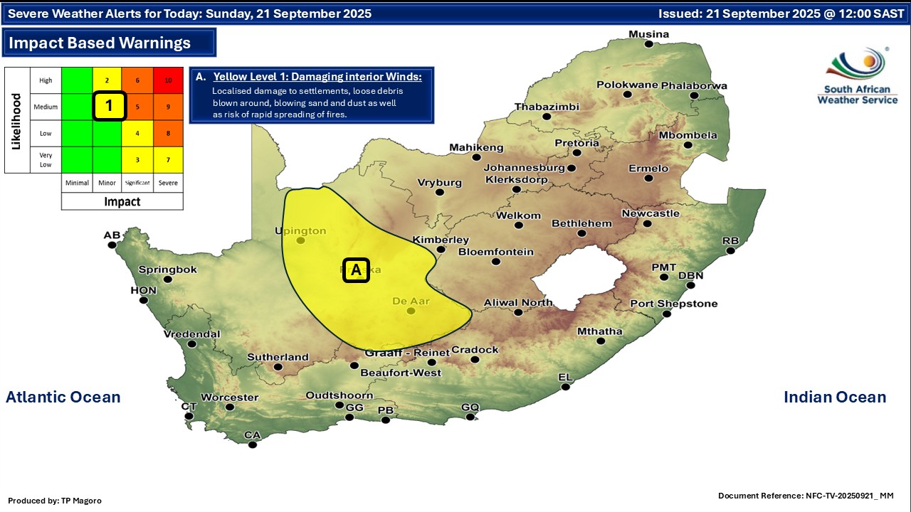
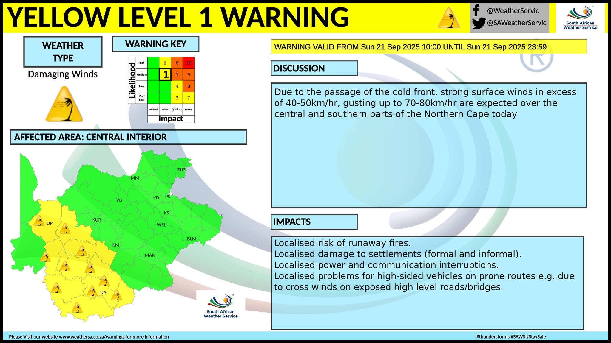
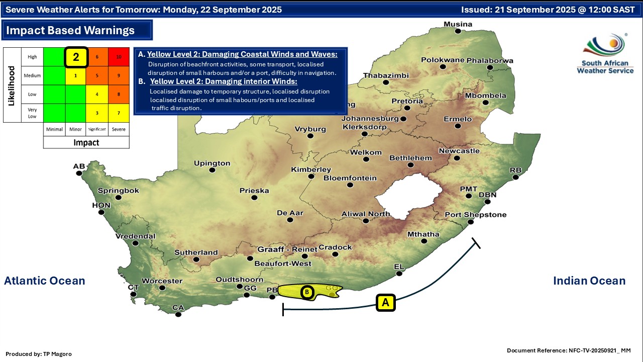
Rain, thunderstorms, a damaging wind warning and light snow possible on SundayBy Staff WriterPublished: 20 September 2025 [updated 21 September] This forecast is for: Sun 21 September 2025 The maps cover: Sun 21 Sep – Tue 23 Sep
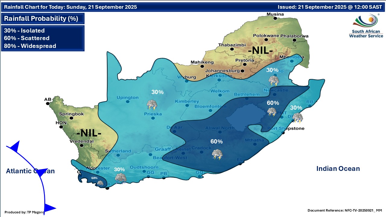
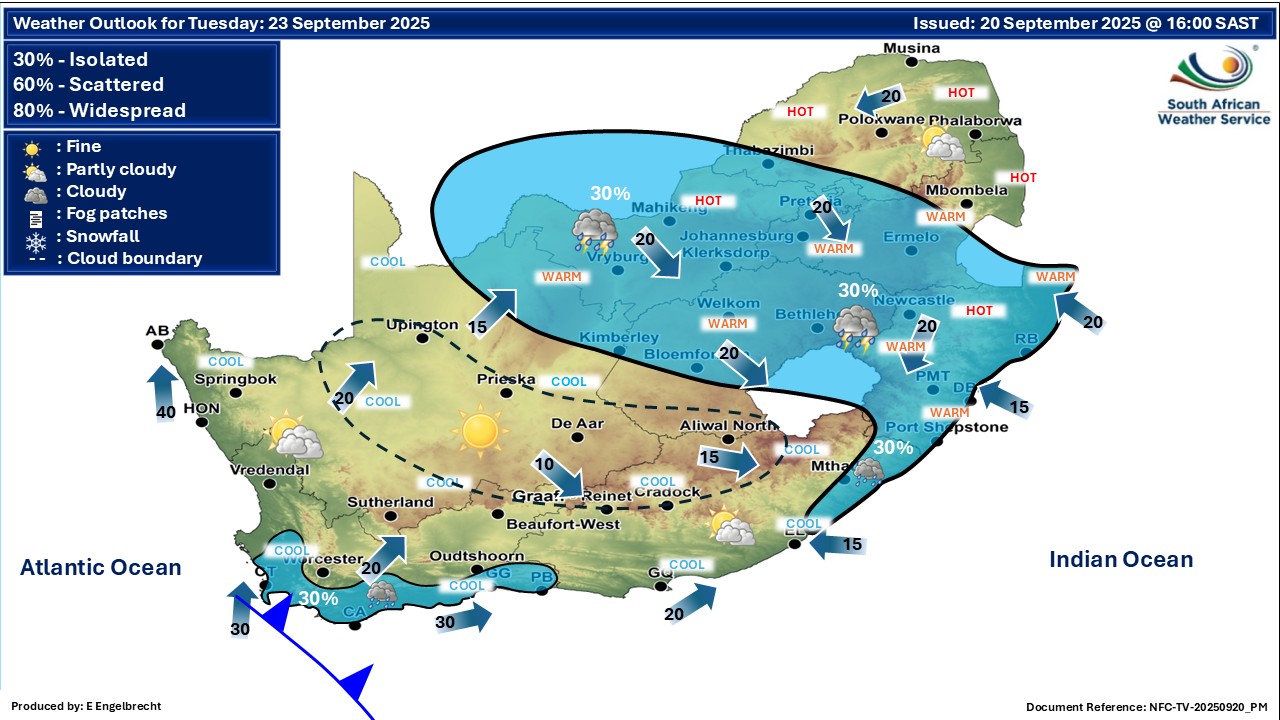
A newer forecast is available by clicking here. From Sunday it should be partly cloudy and warm with isolated showers and thundershowers over many parts of the country. There is also a chance of a light dusting of snow on some of the Western Cape peaks on Sunday night but nothing low-level is expected. From Monday it should be partly cloudy and warm to cool with isolated showers and thundershowers over the central and eastern parts of the country, but scattered over the south-west. ALSO READ: More snowfall possible for Lesotho and South Africa this week. Warnings from the SA Weather Service for Sunday: A. level 1 warning for damaging interior winds, as per the map above. Due to the passage of the cold front, strong surface winds in excess of 40-50km/h, gusting up to 70-80km/h can be expected over the central and southern parts of the Northern Cape. Extremely high fire danger conditions are expected in places over eastern parts of the Northern Cape, the south-western parts of North West and the north-western parts of Free State. Warnings from the SA Weather Service for Monday: A. level 2 warning for damaging coastal winds and waves along the the Eastern Cape coast, as per the map below. B. level 2 warning for damaging interior winds in parts of the Eastern Cape, as per the map below. Regional forecasts from the SA Weather Service for Sunday: GAUTENG Partly cloudy and warm. The expected UVB sunburn index: Very High MPUMALANGA Partly cloudy and cool to warm with isolated showers and thundershowers over the central and southern parts by the afternoon. LIMPOPO Partly cloudy in the extreme south, otherwise fine and warm. NORTH-WEST Partly cloudy, windy, and warm to hot, with isolated showers and thundershowers in the extreme south. THE FREE STATE Partly cloudy, windy and warm to hot, with isolated showers and thundershowers but scattered over the Lesotho border, the southern and eastern parts. THE NORTHERN CAPE Cloudy to partly cloudy, windy, and warm to hot with isolated showers and thundershowers in the east but scattered in the extreme southeast. Morning fog expected over the western interior. The wind along the coast will be light and variable, becoming moderate south-easterly from afternoon. THE WESTERN CAPE Cloudy and warm but cool along coast with isolated to scattered light showers and rain in the evening over the south-western parts and north-eastern interior in the evening. The wind along the coast will be moderate to fresh southerly to south-easterly becoming south-westerly from the afternoon along the south-western coast, but moderate to fresh easterly to south-easterly along the south coast. The expected UVB sunburn index: Very High THE WESTERN HALF OF THE EASTERN CAPE Partly cloudy and cool to warm, becoming cloudy with isolated afternoon showers and thundershowers but scattered in the north. The wind along the coast will be light and variable, becoming fresh to strong north-easterly. THE EASTERN HALF OF THE EASTERN CAPE Partly cloudy and cool to warm, becoming cloudy with isolated showers and thundershowers, but scattered north of the escarpment. The wind along the coast will be moderate south-westerly, becoming moderate to fresh north-easterly by the evening. KWAZULU-NATAL Morning fog over the northern interior, otherwise cloudy to partly cloudy and cool to warm with isolated scattered showers and thundershowers but isolated in the north. The wind along the coast will be moderate to fresh northerly to north-easterly reaching strong in places becoming moderate to fresh southerly to south-westerly from the south by the morning but moderate variable south of Richards Bay from mid-day. The expected UVB sunburn index: Low Travellers forecasts from the SA Weather Service for Sunday: PRETORIA Partly cloudy. Minimum/Maximum: 14/29°C The expected UVB Sunburn Index: Very High JOHANNESBURG Partly cloudy. Minimum/Maximum: 13/27°C VEREENIGING Partly cloudy. Minimum/Maximum: 14/27°C MBOMBELA Partly cloudy with isolated showers. Minimum/Maximum: 15/27°C POLOKWANE Fine. Minimum/Maximum: 13/28°C MAHIKENG Fine and windy. Minimum/Maximum: 16/30°C VRYBURG Partly cloudy and windy. Minimum/Maximum: 14/31°C BLOEMFONTEIN Partly cloudy and windy, with isolated showers and thundershowers. Minimum/Maximum: 14/31°C KIMBERLEY Partly cloudy and windy, with isolated showers and thundershowers. Minimum/Maximum: 18/32°C UPINGTON Partly cloudy and windy, with isolated showers and thundershowers. Minimum/Maximum: 20/36°C CAPE TOWN Fine becoming cloudy with evening light isolated to scattered showers and rain. Wind: Light to moderate southerly to south-easterly becoming north-westerly from the afternoon. Minimum/Maximum: 13/21°C The expected UVB Sunburn Index: Very High GEORGE Fine, becoming cloudy from the afternoon. Wind: Light easterly becoming moderate to fresh easterly to south-easterly from the afternoon. Minimum/Maximum: 9/21°C GQEBERHA Partly cloudy with evening showers and thundershowers. Wind: Light and variable, becoming fresh to strong north-easterly. Minimum/Maximum: 13/21°C EAST LONDON Partly cloudy with showers and thundershowers. Wind: Moderate south-westerly, becoming moderate to fresh north-easterly by the evening. Minimum/Maximum: 15/22°C DURBAN Partly cloudy with isolated showers and rain. Wind: Moderate to fresh northerly to north-easterly reaching strong in places becoming moderate to fresh southerly to south-westerly by the morning but moderate variable from mid-day. Minimum/Maximum: 18/25°C The expected UVB Sunburn Index: Low RICHARDS BAY Partly cloudy with scattered showers and rain. Wind: Moderate to fresh northerly to north-easterly reaching strong at times but moderate variable south from mid-day. Minimum/Maximum: 17/31°C PIETERMARITZBURG Morning fog patches, otherwise partly cloudy with isolated showers and rain. Minimum/Maximum: 12/29°C This forecast is usually updated a few times per day.
Please be sure to send photos and videos to us via whatsapp and also tell us where and when they were taken. Follow our channels
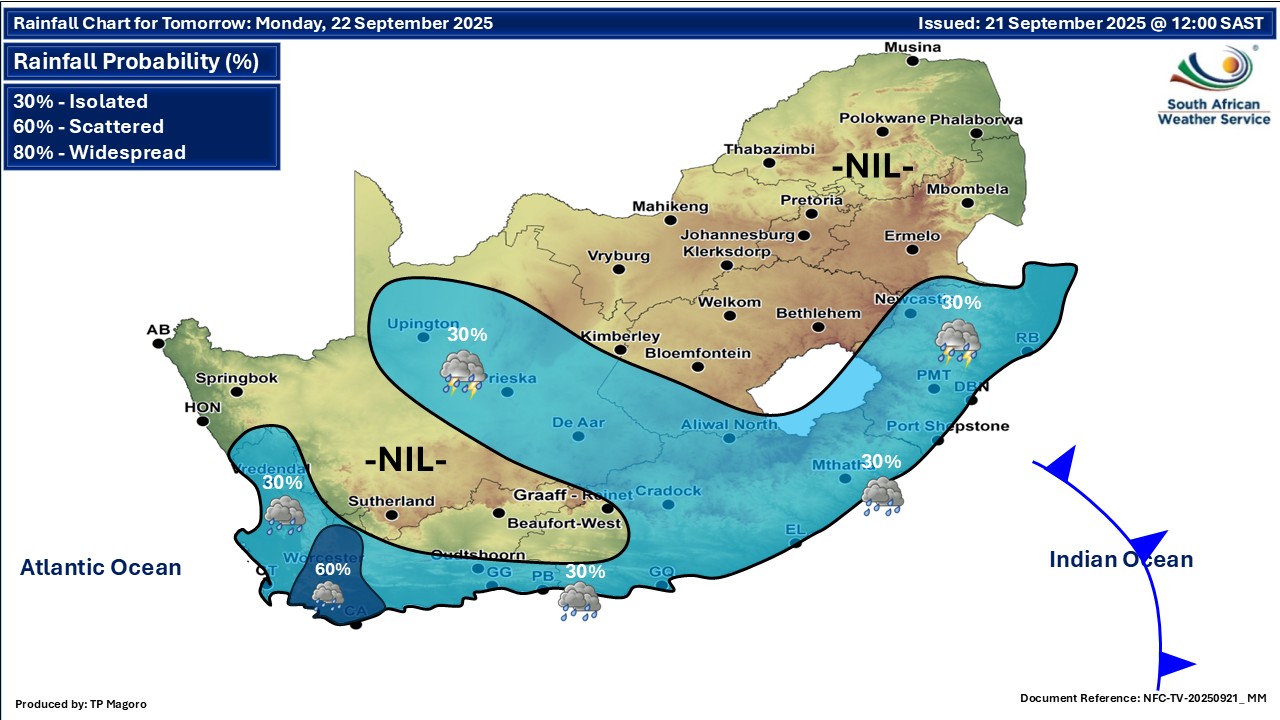
Maps for Monday 22 September
  Maps for Tuesday 23 September
|