
    Maps partly based on data from the SA Weather Service
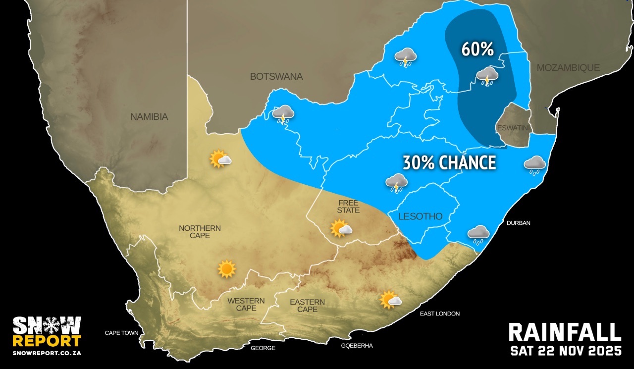
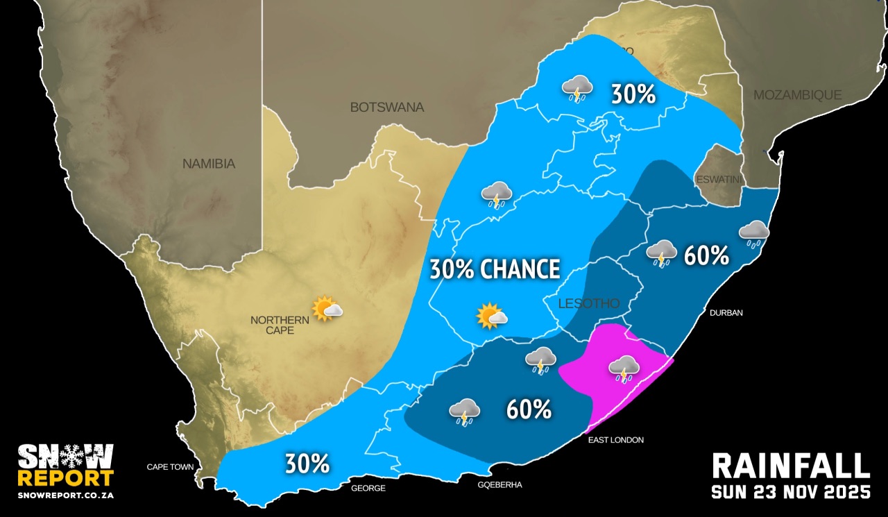
FRIDAY WEATHER: Fog, wind, hail, heavy rain and a level 4 severe thunderstorm warning issued for the north-eastBy Staff WriterPublished: 20 November 2025 [updated 21 November] This forecast is for: Fri 21 November 2025 The maps cover: Fri 21 Nov – Sun 23 Nov
The latest forecast is available by clicking here. Very hot to extremely hot and uncomfortable conditions are expected over Kamiesberg Municipality (Northern Cape) and over the West Coast District (Western Cape) on Friday. Partly cloudy and cool conditions are expected over the central and eastern parts of the country on the weekend, with isolated to scattered showers and thundershowers possible, but widespread in places over the eastern half of the Eastern Cape on Sunday. Warnings from the SA Weather Service for Friday: level 4 warning severe thunderstorms – slow moving thunderstorms resulting in persistent rainfall and large amounts of hail may result in flooding of roads, settlements and low-lying areas, resulting in closure of some bridges and roads over the north-eastern Highveld of Mpumalanga. A. level 1 warning severe thunderstorms leading to heavy downpours, localised flooding of susceptible roads, low-lying areas and bridges, large amounts of small hail as well as strong damaging winds is expected over the northeastern parts of the North West, about half of Limpopo, most of Gauteng and the western part of Mpumalanga as per the map above. Extremely high fire danger conditions are expected over the Matzikama and Swartland Municipalities of the Western Cape. Regional forecasts from the SA Weather Service for Friday: GAUTENG Partly cloudy and warm with scattered afternoon showers and thundershowers. MPUMALANGA Cloudy and cool to warm with scattered showers and thundershowers, but isolated in the Lowveld. LIMPOPO Cloudy in the morning, otherwise partly cloudy and warm with scattered showers and thundershowers, but isolated in the western parts, Limpopo Valley and Lowveld. NORTH-WEST Morning fog in the extreme east, otherwise partly cloudy and warm to hot, with isolated to scattered showers and thundershowers in the central and eastern parts. THE FREE STATE Fine and warm to hot, becoming partly cloudy with isolated showers and thundershowers in the eastern parts where morning fog patches are expected. THE NORTHERN CAPE Fine and hot to very hot, becoming partly cloudy in the north in the afternoon in the extreme eastern parts. The wind along the coast will be fresh to strong south-easterly. THE WESTERN CAPE Partly cloudy and cool to warm along the south coast and adjacent interior, otherwise fine and hot but very hot to extreme hot in the western parts. The wind along the coast will be light to moderate south-westerly along the south coast in the morning, otherwise light to moderate southerly to south-easterly but fresh to strong along the west coast. THE WESTERN HALF OF THE EASTERN CAPE Partly cloudy along the coast and adjacent interior, otherwise fine and warm. The wind along the coast will be light to moderate south-westerly. THE EASTERN HALF OF THE EASTERN CAPE Morning fog in places south of the escarpment, otherwise partly and warm, becoming cloudy with isolated rain and showers along the Wildcoast in the afternoon. The wind along the coast will be moderate to fresh south-westerly. KWAZULU-NATAL Morning fog over the interior, otherwise cloudy and cool to warm with isolated showers and thundershowers. The wind along the coast will be moderate easterly to south-easterly but north-easterly in the extreme north. Travellers forecasts from the SA Weather Service for Friday: PRETORIA Partly cloudy with scattered afternoon showers and thundershowers. Minimum/Maximum: 15/27°C The expected UVB Sunburn Index: High JOHANNESBURG Partly cloudy with scattered afternoon showers and thundershowers. Minimum/Maximum: 13/26°C VEREENIGING Partly cloudy with scattered afternoon showers and thundershowers. Minimum/Maximum: 14/27°C MBOMBELA Cloudy with scattered showers and thundershowers. Minimum/Maximum: 14/24°C POLOKWANE Cloudy with scattered showers and thundershowers. Minimum/Maximum: 16/27°C MAHIKENG Partly cloudy with isolated afternoon showers and thundershowers. Minimum/Maximum: 18/32°C VRYBURG Fine, becoming partly cloudy in the afternoon. Minimum/Maximum: 17/33°C BLOEMFONTEIN Fine, becoming partly cloudy in the afternoon. Minimum/Maximum: 16/29°C KIMBERLEY Fine, becoming partly cloudy in the afternoon. Minimum/Maximum: 17/32°C UPINGTON Fine. Minimum/Maximum: 21/37°C CAPE TOWN Fine and windy. Wind: Moderate to fresh south-easterly, becoming strong in the afternoon. Minimum/Maximum: 20/27°C The expected UVB Sunburn Index: Extreme GEORGE Partly cloudy. Wind: Light and variable, becoming light to moderate south-easterly in the afternoon. Minimum/Maximum: 13/23°C GQEBERHA Partly cloudy. Wind: Light to moderate south-westerly. Minimum/Maximum: 16/23°C EAST LONDON Partly cloudy. Wind: Moderate to fresh south-westerly. Minimum/Maximum: 15/24°C DURBAN cloudy with isolated afternoon showers and thundershowers. Wind: Light to moderate easterly to south-easterly. Minimum/Maximum: 18/25°C The expected UVB Sunburn Index: High RICHARDS BAY Cloudy with isolated afternoon showers and thundershowers. Wind: Light to moderate easterly to south-easterly. Minimum/Maximum: 17/28°C PIETERMARITZBURG Morning fog, otherwise cloudy with isolated afternoon showers and thundershowers. Minimum/Maximum: 14/26°C This forecast is usually updated a few times per day.
Please be sure to send photos and videos to us via whatsapp and also tell us where and when they were taken. Follow our channels
|