
   Swipe left or right for more maps, and see below for others
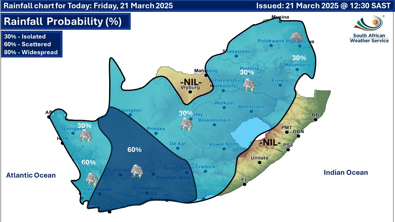
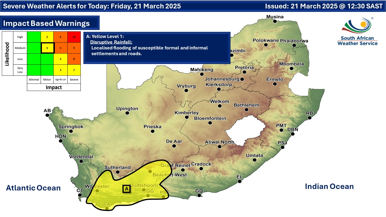
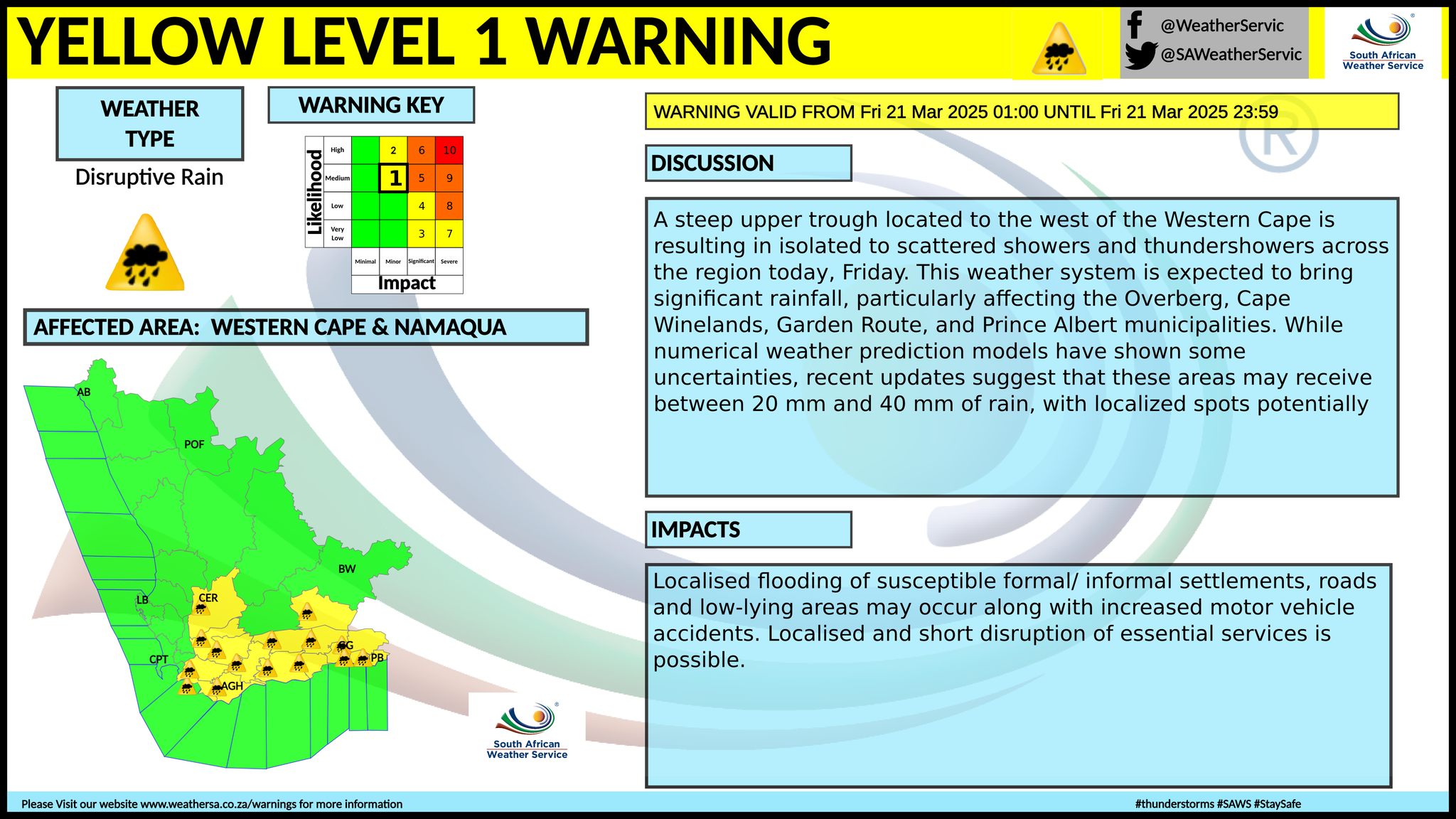
Cooler conditions in the west on Friday and a disruptive rainfall warning for the Western CapeBy Staff WriterPublished: 20 March 2025 [updated 21 March] This forecast is for: Fri 21 March 2025 The maps cover: Fri 21 Mar – Sun 23 Mar
A newer forecast is available by clicking here. The west of the country and part of the interior cools off on Friday and morning fog can be expected as per the map, according to SA Weather, but a heat wave with persistently high temperatures is expected in places over Alfred Nzo District of the Eastern Cape until Friday (A on the map above). Hot and humid weather will result in extremely uncomfortable conditions in places over Sarah Baartman DM, Amatole DM, Buffalo City Metro and OR Tambo DM in the Eastern Cape. (B on the map above). Warnings from the SA Weather Service for Friday: A. yellow level 1 warning disruptive rainfall is expected over parts of the Western Cape, as per the updated map above. A steep upper trough located to the west of the Western Cape is resulting in isolated to scattered showers and thundershowers across the region on Friday. This weather system is expected to bring significant rainfall, particularly affecting the Overberg, Cape Winelands, Garden Route, and Prince Albert municipalities. While numerical weather prediction models have shown some uncertainties, recent updates suggest that these areas may receive between 20 mm and 40 mm of rain, with localized spots potentially receiving even more. Regional forecasts from SAWS for Friday: 1. GAUTENG Partly cloudy and cool with isolated showers and thundershowers. The expected UVB sunburn index: Moderate 2. MPUMALANGA Cloudy with morning fog in places, otherwise partly cloudy and cool to warm with isolated showers and thundershowers. 3. LIMPOPO Cloudy in the morning, otherwise partly cloudy and warm with isolated showers and thundershowers. It will be hot in the southern Lowveld. 4. NORTH WEST Partly cloudy and warm with isolated showers and thundershowers. 5. FREE STATE Partly cloudy and cool to warm, with isolated showers and thundershowers. 6. NORTHERN CAPE Morning fog along the coast, otherwise cloudy and cool to warm with isolated showers and thundershowers, but partly cloudy in the east. The wind along the coast will be light north-westerly. 7. WESTERN CAPE Fog along the coast in the morning and by the evening, otherwise cloudy and cool to warm with scattered showers and thundershowers. It will be hot in the south-east. The wind along the coast will be light to moderate north-westerly in the west, but easterly in the south. The expected UVB sunburn index: High 8. WESTERN HALF OF THE EASTERN CAPE Cloudy with morning fog in places along the coast and adjacent interior, otherwise partly cloudy and cool to warm with isolated thundershowers in the afternoon. It will be hot in places in the south-west. The wind along the coast will be light to moderate north-easterly. 9. EASTERN HALF OF THE EASTERN CAPE Partly cloudy and warm to hot. The wind along the coast will be light north-easterly. 10. KWAZULU-NATAL Morning fog over the interior, otherwise partly cloudy and warm to hot. Isolated showers and thundershowers are expected over the north-west. The wind along the coast will be fresh to strong north-easterly. The expected UVB sunburn index: High Travellers forecasts from SAWS for Friday: PRETORIA Partly cloudy with isolated showers and thundershowers. Minimum/Maximum: 16/26°C The expected UVB Sunburn Index: Moderate JOHANNESBURG Partly cloudy with isolated showers and thundershowers. Minimum/Maximum: 14/24°C VEREENIGING Partly cloudy with isolated showers and thundershowers. Minimum/Maximum: 14/26°C MBOMBELA Cloudy with morning fog, otherwise partly cloudy with isolated showers and thundershowers. Minimum/Maximum: 16/29°C POLOKWANE Cloudy in the morning, otherwise partly cloudy with isolated showers and thundershowers. Minimum/Maximum: 15/27°C MAHIKENG Partly cloudy with isolated afternoon showers and thundershowers. Minimum/Maximum: 15/26°C VRYBURG Partly cloudy with isolated afternoon showers and thunder-showers. Minimum/Maximum: 16/28°C BLOEMFONTEIN Partly cloudy with isolated afternoon showers and thunder-showers. Minimum/Maximum: 15/28°C KIMBERLEY Partly cloudy with isolated showers and thundershowers. Minimum/Maximum: 17/29°C UPINGTON Cloudy with isolated showers and thundershowers. Minimum/Maximum: 22/28°C CAPE TOWN Cloudy with morning fog and scattered showers and rain in the morning. Wind: Light north-westerly. Minimum/Maximum: 19/22°C The expected UVB Sunburn Index: High GEORGE Partly cloudy with morning fog, with scattered showers and thundershowers. Wind: Light easterly. Minimum/Maximum: 19/25°C GQEBERHA Cloudy with morning fog, otherwise partly cloudy with isolated thunderstorms in the afternoon. Wind: Light north-easterly. Minimum/Maximum: 19/25°C EAST LONDON Fine. Wind: Light north-easterly. Minimum/Maximum: 20/28°C DURBAN Partly cloudy. Wind: Moderate to fresh northerly to north-easterly. Minimum/Maximum: 19/29°C The expected UVB Sunburn Index: High RICHARDS BAY Fine. Wind: Fresh to strong northerly to north-easterly. Minimum/Maximum: 18/31°C PIETERMARITZBURG Morning fog patches, otherwise partly cloudy. Minimum/Maximum: 13/30°C This forecast is usually updated a few times per day.
Please be sure to send photos and videos to us via whatsapp and also tell us where and when they were taken. Follow our channels
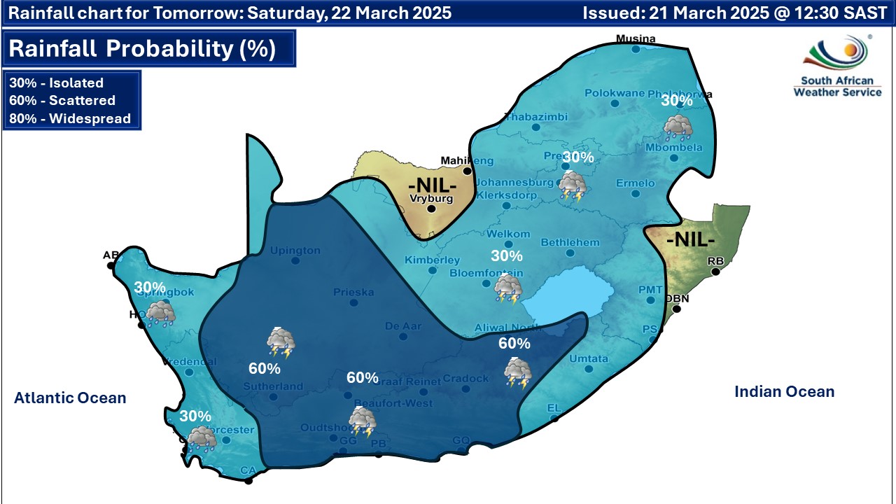
Maps for Saturday 22 March
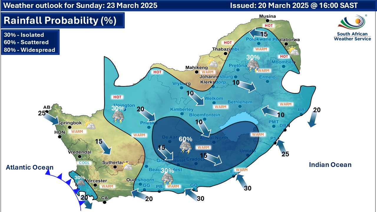
 Maps for Sun 23 March
|