
WEDNESDAY WEATHER: A warning for severe thunderstorms in the central interior and damaging winds off the coast
By Staff WriterPublished: 20 January 2026 [updated 21 January]
This forecast is for: Wed 21 January 2026
The maps cover: Wed 21 Jan – Fri 23 Jan
| SHARE TO |
The latest forecast is available by clicking here.
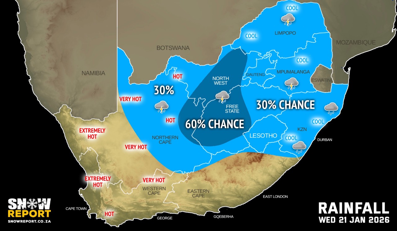
From Wednesday it should be partly cloudy and warm to hot with isolated showers and thundershowers possible over the central and eastern parts of the country.
It will be hot in places in the south-western interior and morning fog can be expected in a few provinces.
Very hot and uncomfortable conditions are expected over the western parts of Namakwa Municipal District in the Northern Cape as well as the West Coast, and south-western parts of Cape Winelands Municipal District in the Western Cape.
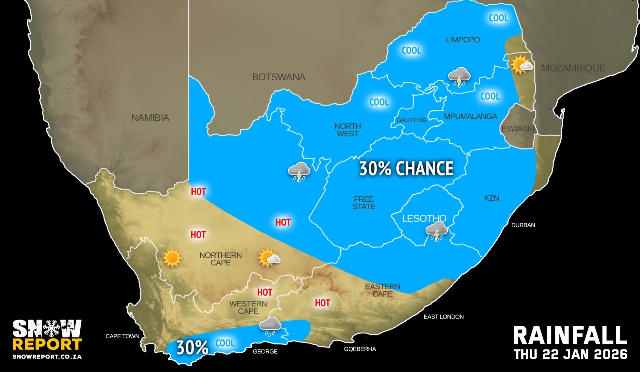
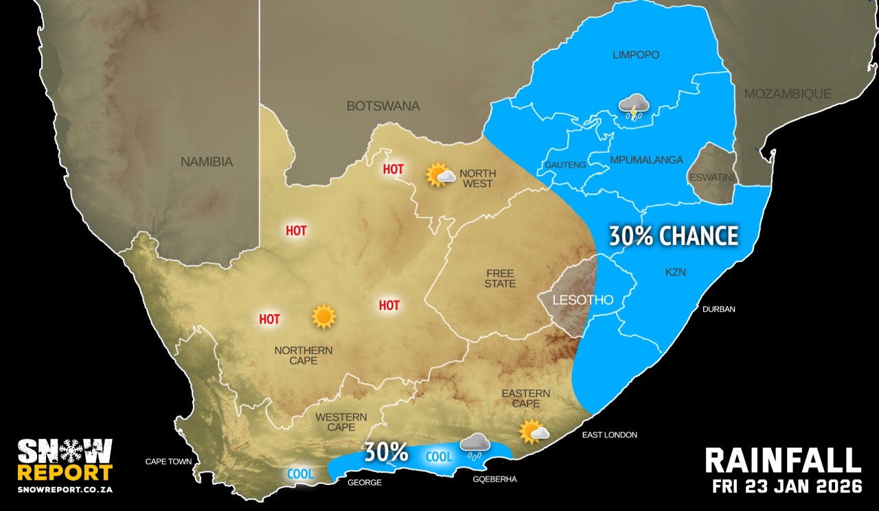
From Thursday a gradual decrease in the chances of rainfall is indicated for the eastern parts of South Africa following the widespread and heavy rainfall across parts of Limpopo and Mpumalanga. While isolated showers may still occur, conditions are expected to become relatively drier, allowing catchment areas some relief after the prolonged wet conditions.
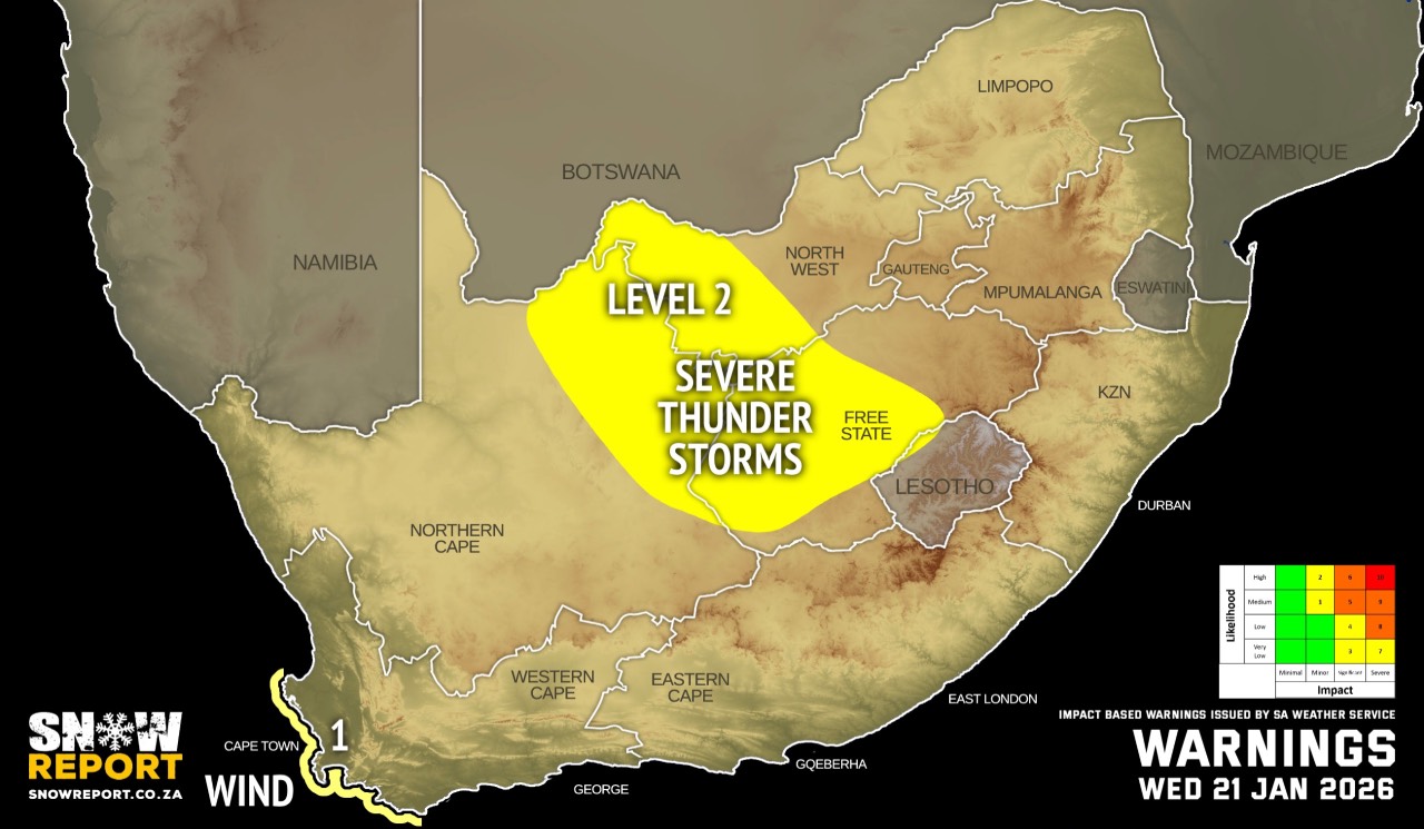
Warnings from the SA Weather Service for Wednesday:
A. level 2 warning for severe thunderstorms resulting in localised damage to infrastructure, settlements informal), property, vehicles, livelihood and livestock over the central and eastern parts of North West, central and western parts of Free State as well as north-eastern parts of Northern Cape.
B. level 1 warning for damaging coastal winds resulting in difficulty in navigation at sea is expected between Cape Columbine and Cape Agulhas.
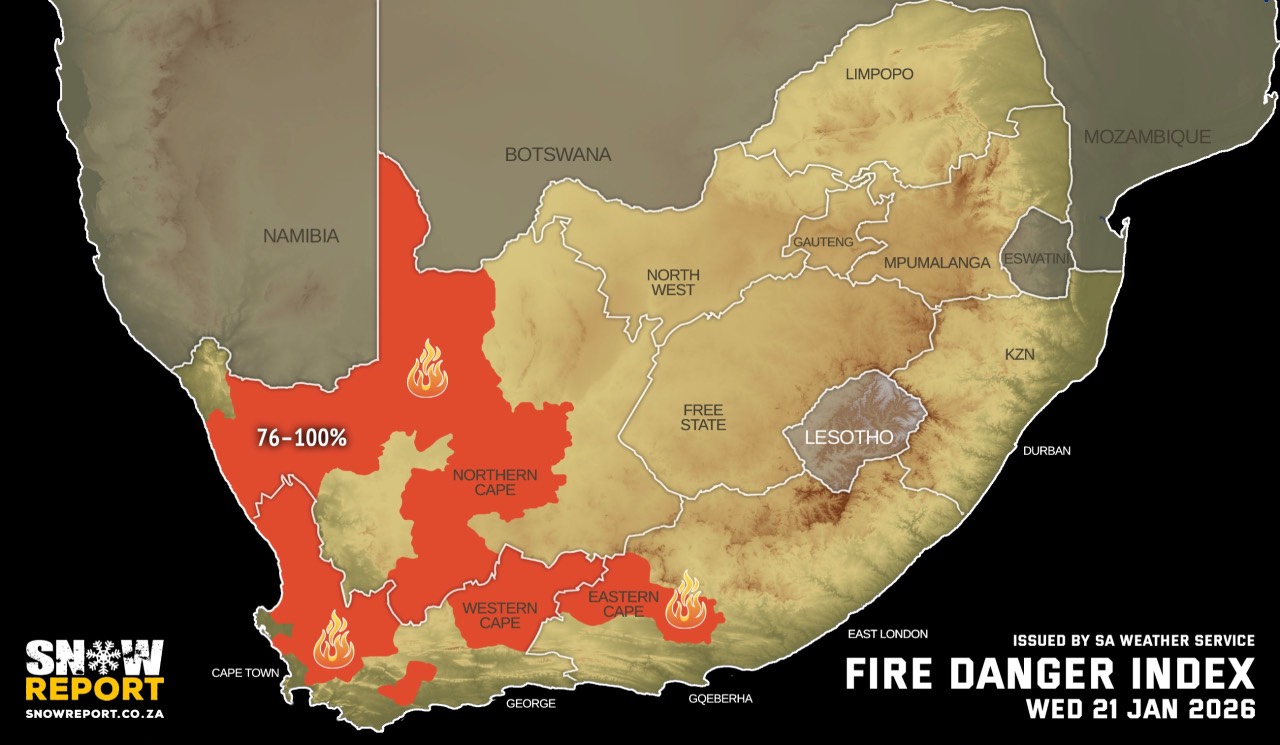
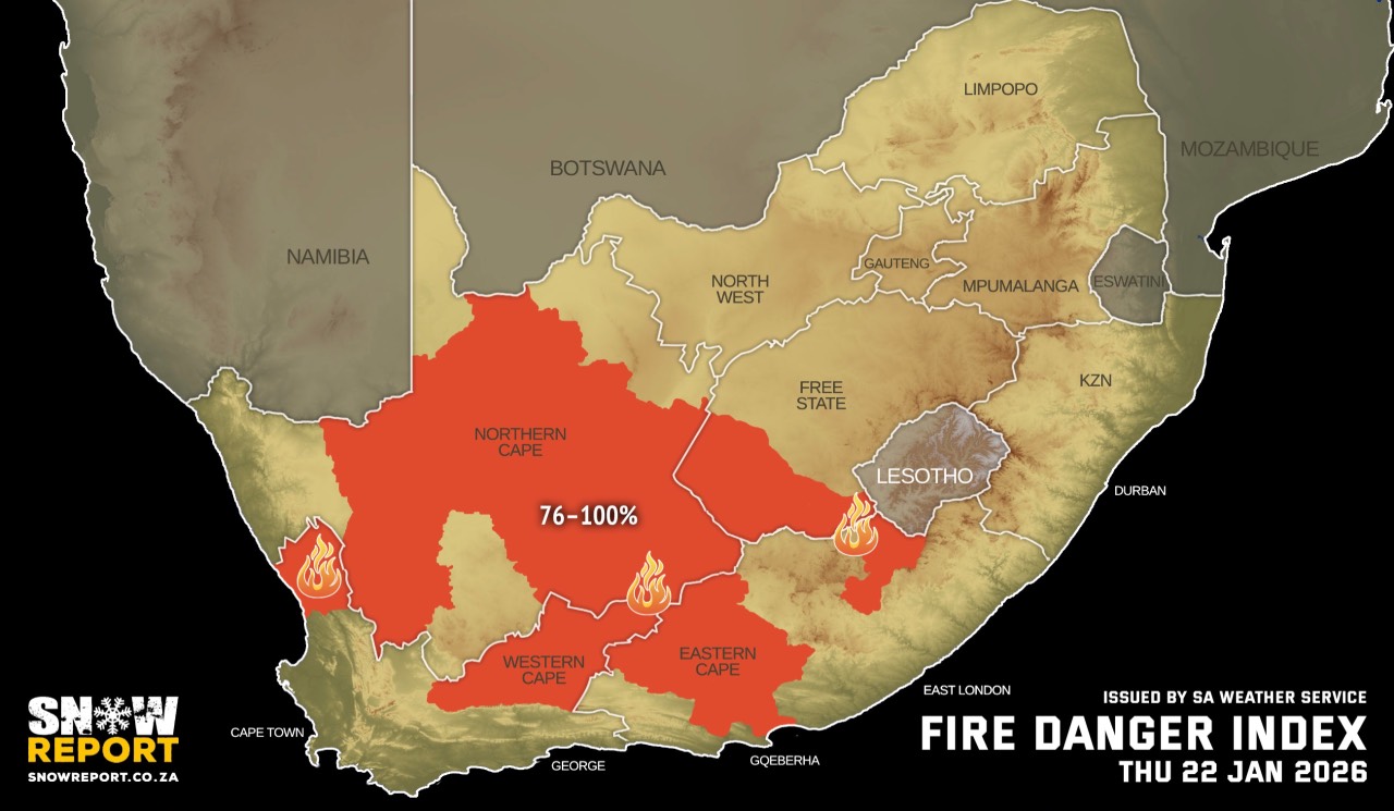
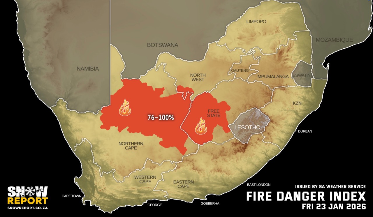
Extremely high fire danger conditions are expected over the interior of Namakwa local district of Northern Cape as well as City of Cape Town Local District, Bergrivier and Drakenstein local Municipalities of Western Cape. See fire map danger maps for the next few days above.
Regional forecasts from the SA Weather Service for Wednesday:
GAUTENG
Partly cloudy and cool to warm with isolated showers and thundershowers.
MPUMALANGA
Morning fog patches on the escarpment and the Highveld areas, otherwise partly cloudy and cool to cold with isolated showers and thundershowers.
LIMPOPO
Cloudy and cool with isolated showers and thundershowers.
NORTH-WEST
Cloudy and warm with isolated to scattered showers and thundershowers.
THE FREE STATE
Morning fog patches in the east, otherwise partly cloudy and warm to hot with isolated showers and thundershowers but scattered over the central and western parts.
THE NORTHERN CAPE
Warm in the north-west, otherwise fine and hot to very hot but partly cloudy in the central and east with isolated showers and thundershowers but scattered in the extreme east in the afternoon. The wind along the coast will be fresh westerly to south-westerly.
THE WESTERN CAPE
Fine and hot to very hot but cool to warm in the south. The wind along the coast will be light to moderate south-easterly to easterly along the west coast, reaching fresh to strong along the south-west and south coast. It will moderate along the south coast from the evening.
THE WESTERN HALF OF THE EASTERN CAPE
Partly cloudy and warm to hot with isolated afternoon thundershowers in the north. It will be fine in the south-west. The wind along the coast will be fresh easterly to south-easterly in the afternoon.
THE EASTERN HALF OF THE EASTERN CAPE
Fine and cool but partly cloudy with isolated thundershowers in the north. The wind along the coast will be moderate north-easterly, becoming fresh north easterly in the afternoon.
KWAZULU-NATAL
Morning fog over the interior, otherwise partly cloudy and cool to warm with isolated showers and thundershowers. The wind along the coast will be moderate easterly to south-easterly.
Travellers forecasts from the SA Weather Service for Wednesday:
PRETORIA
Partly cloudy with isolated showers and thundershowers.
Minimum/Maximum: 15/26°C
JOHANNESBURG
Partly cloudy with isolated showers and thundershowers.
Minimum/Maximum: 14/25°C
VEREENIGING
Partly cloudy with isolated showers and thundershowers.
Minimum/Maximum: 15/26°C
MBOMBELA
Partly cloudy with isolated showers and thundershowers.
Minimum/Maximum: 18/22°C
POLOKWANE
Cloudy with isolated showers and thundershowers.
Minimum/Maximum: 16/22°C
MAHIKENG
Cloudy with scattered showers and thundershowers.
Minimum/Maximum: 16/26°C
VRYBURG
Cloudy with scattered afternoon thundershowers.
Minimum/Maximum: 17/29°C
BLOEMFONTEIN
Partly cloudy with scattered afternoon thundershowers in the afternoon.
Minimum/Maximum: 15/30°C
KIMBERLEY
Partly cloudy with scattered afternoon thundershowers.
Minimum/Maximum: 18/31°C
UPINGTON
Partly cloudy with isolated afternoon thundershowers.
Minimum/Maximum: 21/37°C
CAPE TOWN
Fine.
Wind: Fresh to strong southerly to south-easterly.
Minimum/Maximum: 19/31°C
GEORGE
Fine.
Wind: Light and variable becoming moderate to fresh south-easterly in the afternoon.
Minimum/Maximum: 14/25°C
GQEBERHA
Fine.
Wind: Moderate westerly, becoming southerly to south-easterly in the afternoon.
Minimum/Maximum: 16/28°C
EAST LONDON
Fine.
Wind: Moderate to fresh southerly to south-easterly.
Minimum/Maximum: 16/25°C
DURBAN
Partly cloudy with isolated showers and thundershowers.
Wind: Light to moderate southerly to south-westerly, becoming easterly to north-easterly in the afternoon.
Minimum/Maximum: 19/26°C
RICHARDS BAY
Partly cloudy with isolated showers and thundershowers.
Wind: Light to moderate southerly to south-westerly, becoming easterly to north-easterly from late afternoon.
Minimum/Maximum: 19/26°C
PIETERMARITZBURG
Morning fog, otherwise partly cloudy with isolated showers and rain.
Minimum/Maximum: 14/25°C
This forecast is usually updated a few times per day.
| SHARE TO |
Please be sure to send photos and videos to us via whatsapp and also tell us where and when they were taken.
Follow our channels