
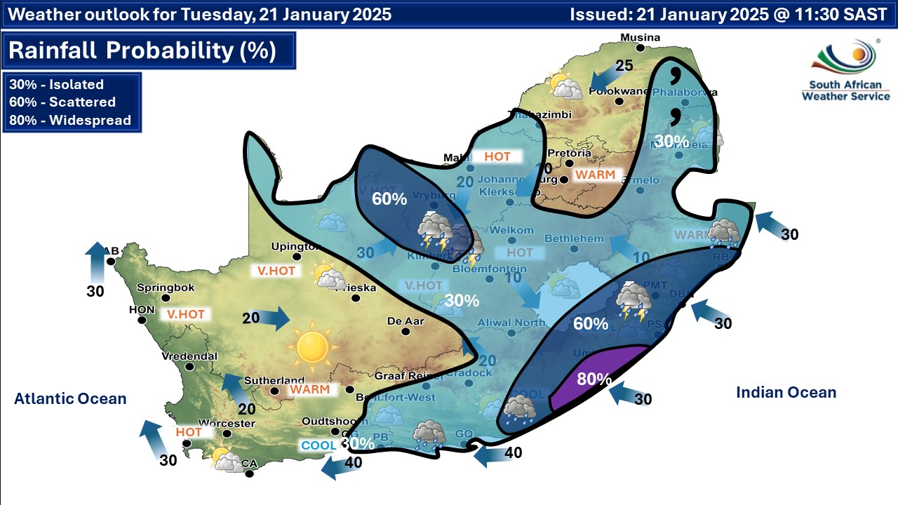
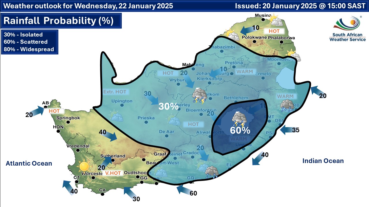
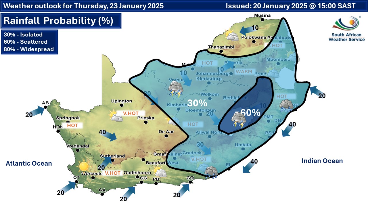
 Rainfall probability. More maps below the forecast
Damaging winds, severe thunderstorms and disruptive rainfall on Tuesday20 January 2025 [updated 21 January]By Staff Writer
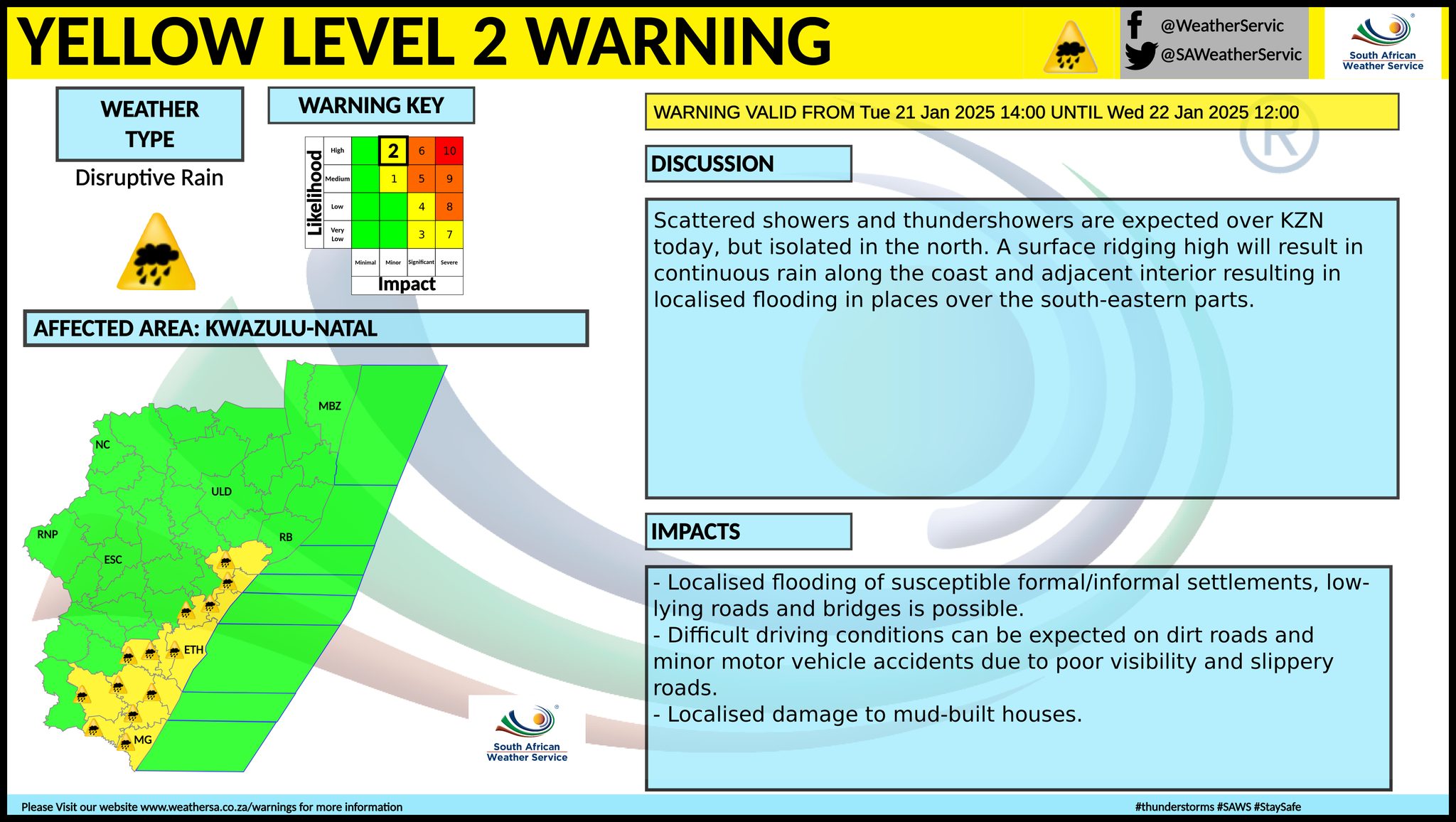
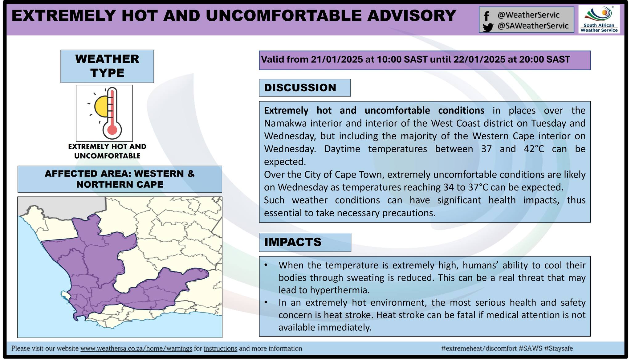
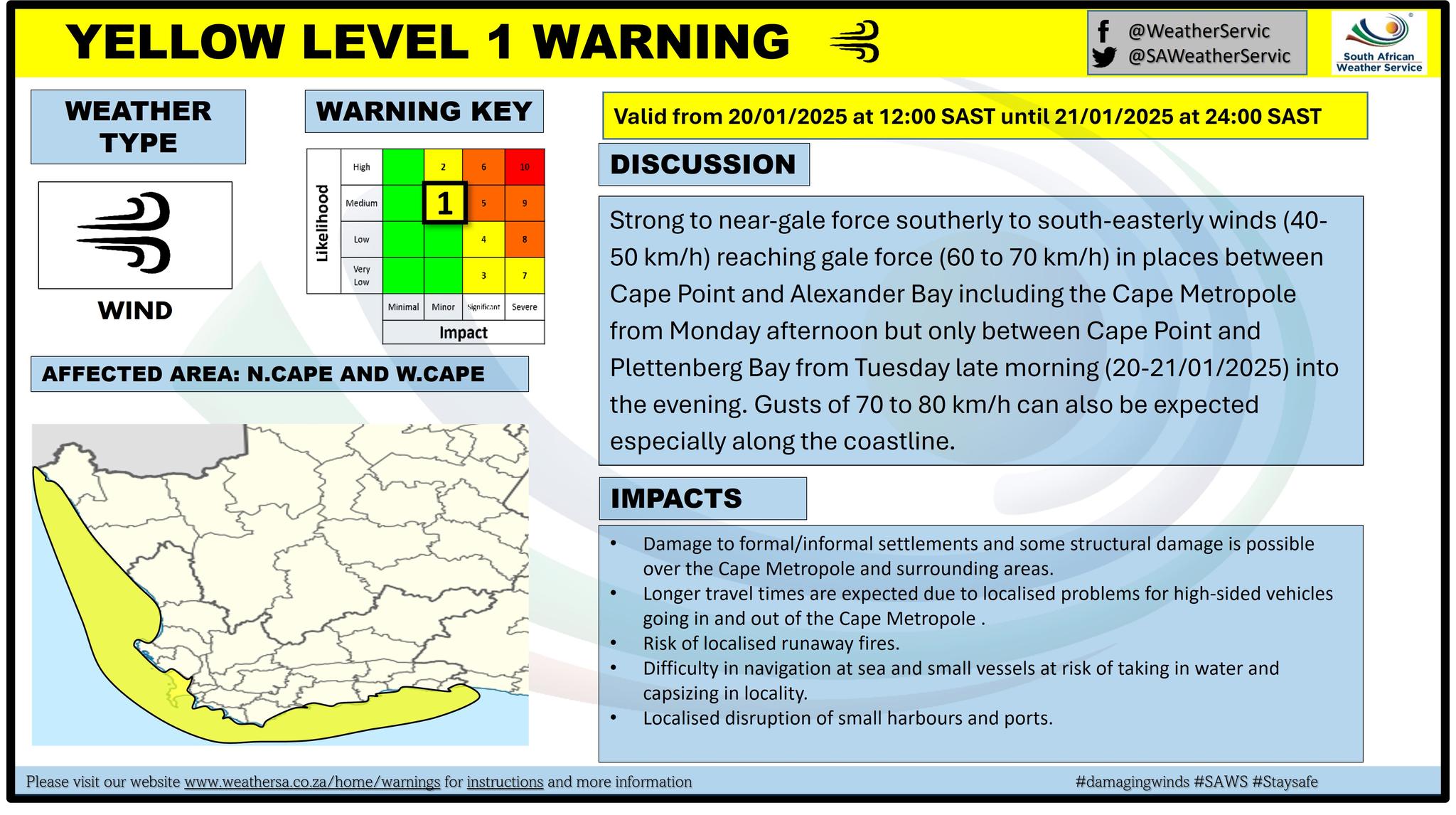
A newer forecast is available by clicking here but any warnings for Tuesday may still apply. Isolated to scattered showers and thundershowers are expected over the central to eastern parts of the country but widespread along the south eastern coast of the country, according to the SA Weather Service. Severe thunderstorms can be expected over the interior but damaging winds along the south coast of Western Cape and disruptive rain over the eastern parts of KwaZulu-Natal. From Wednesday it is indicated to be partly cloudy and hot to very hot but extremely hot in the Northern Cape, with isolated to scattered showers and thundershowers in places over the central and eastern parts of South Africa. Extremely hot and uncomfortable conditions in places over the Namakwa interior and interior of the West Coast district on Tuesday and Wednesday, but including the majority of the Western Cape interior on Wednesday. Daytime temperatures between 37°C and 42°C can be expected. Extremely uncomfortable conditions are likely over the City of Cape Town on Wednesday as temperatures reaching 34°C to 37°C can be expected. Warnings from the SA Weather Service for Tuesday: A. yellow level 1 warning damaging wind resulting in difficulty in navigation at sea is expected between Cape Point and Plettenberg Bay. B. yellow level 2 warning severe thunderstorms with heavy downpours, strong damaging wind and small amount of hail leading to localised flooding, damage to infrastructure and property and excessive lightning are expected over the north-east of Northern Cape and the west of both Free State and North West. C. yellow level 2 warning disruptive rainfall resulting in flooding in parts of KwaZulu-Natal, as per the map below. Extremely high fire danger conditions are expected over the northern parts of the Northern Cape as well as the south-western parts of the Free State. Regional forecasts from SAWS for Tuesday: 1. GAUTENG Partly cloudy and warm. The expected UVB sunburn index: High 2. MPUMALANGA Hot in the Lowveld where it will be cloudy, otherwise partly cloudy and warm with isolated showers and thundershowers in the east. 3. LIMPOPO Partly cloudy and warm to hot with isolated showers and rain in the east where it will be cloudy. 4. NORTH WEST Partly cloudy and warm to hot with isolated showers and thundershowers, except the extreme east. It will be windy in the west and the extreme south. 5. FREE STATE Morning fog patches in the east, otherwise partly cloudy, windy and warm to hot with isolated showers and thundershowers. 6. NORTHERN CAPE Fine and hot to very hot but warm in the extreme south-west and along the coast. It will be partly cloudy in the north-east with isolated afternoon showers and thundershowers. The wind along the coast will be light and variable in the morning becoming fresh to strong southerly to south-easterly by the afternoon. 7. WESTERN CAPE Partly cloudy in the south, otherwise fine and hot to very hot but cool along the south coast where it will be cloudy with a chance light rain in the morning. The wind along the coast will be moderate to fresh southerly to south-easterly along the west coast, otherwise fresh to strong easterly. The expected UVB sunburn index: Extreme 8. WESTERN HALF OF THE EASTERN CAPE Cloudy and cool with isolated showers and rain. The wind along the coast will be Fresh to strong easterly. 9. EASTERN HALF OF THE EASTERN CAPE Morning fog, otherwise cloudy and cool with scattered showers and rain, but widespread along the coast north-east of Coffee Bay. The wind along the coast will be Moderate to fresh south-easterly to easterly. 10. KWAZULU-NATAL Morning fog over the interior, otherwise cloudy and cool to warm with scattered showers and rain but isolated in the north. The wind along the coast will be moderate to fresh southerly to south-easterly. The expected UVB sunburn index: Very High Travellers forecasts from SAWS for Tuesday: PRETORIA Partly cloudy. Minimum/Maximum: 17/29°C The expected UVB Sunburn Index: High JOHANNESBURG Partly cloudy. Minimum/Maximum: 16/27°C VEREENIGING partly cloudy. Minimum/Maximum: 16/28°C MBOMBELA Cloudy with isolated showers and rain. Minimum/Maximum: 17/27°C POLOKWANE Cloudy in the morning, otherwise partly cloudy. Minimum/Maximum: 17/29°C MAHIKENG Partly cloudy with isolated showers and thundershowers. Minimum/Maximum: 21/32°C VRYBURG Partly cloudy, and windy with isolated showers and thundershowers. Minimum/Maximum: 21/35°C BLOEMFONTEIN Partly cloudy, and windy with isolated showers and thundershowers. Minimum/Maximum: 18/34°C KIMBERLEY Partly cloudy, and windy with isolated showers and thundershowers. Minimum/Maximum: 19/38°C UPINGTON Fine. Minimum/Maximum: 20/39°C CAPE TOWN Partly cloudy. Wind: Moderate to fresh south-easterly. Minimum/Maximum: 17/30°C The expected UVB Sunburn Index: Extreme GEORGE Cloudy with a chance light rain in the morning. Wind: Light to moderate easterly in the morning, otherwise fresh to strong. Minimum/Maximum: 17/24°C GQEBERHA Cloudy with isolated showers and rain. Wind: Fresh to strong easterly. Minimum/Maximum: 19/23°C EAST LONDON Cloudy with scattered showers and rain. Wind: Moderate to fresh south-easterly to easterly. Minimum/Maximum: 19/22°C DURBAN Cloudy with scattered showers and rain. Wind: Moderate to fresh southerly to south-easterly reaching strong at times. Minimum/Maximum: 22/26°C The expected UVB Sunburn Index: Very High RICHARDS BAY Cloudy with scattered showers and rain. Wind: Moderate to fresh southerly to south-easterly reaching strong at times. Minimum/Maximum: 23/28°C PIETERMARITZBURG Morning fog patches, otherwise cloudy with scattered showers and rain. Minimum/Maximum: 17/24°C This forecast is usually updated a few times per day.
Please be sure to send photos and videos to us via whatsapp and also tell us where and when they were taken. Follow our channels
Issued on Tuesday
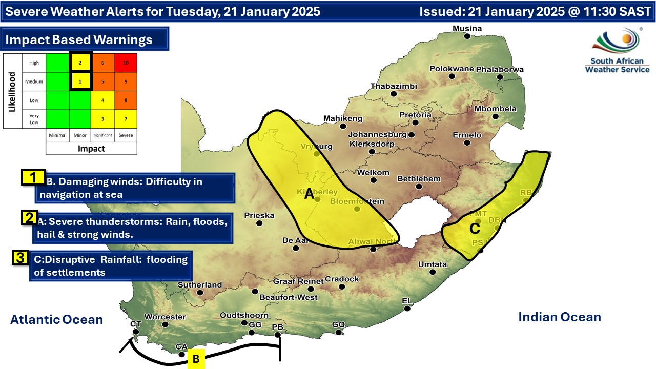 C. seems to be level 2 and not 3 as indicated on the map above.
  Issued on Monday
  Issued on Sunday
|