
  Maps partly based on data from the SA Weather Service
SUNDAY WEATHER: Disruptive rain or thunderstorm warnings for eight provinces and damaging coastal winds – LEVEL 5 for LimpopoBy Staff WriterPublished: 20 December 2025 [updated 21 December] This forecast is for: Sun 21 December 2025 The maps cover: Sun 21 Dec – Sun 21 Dec
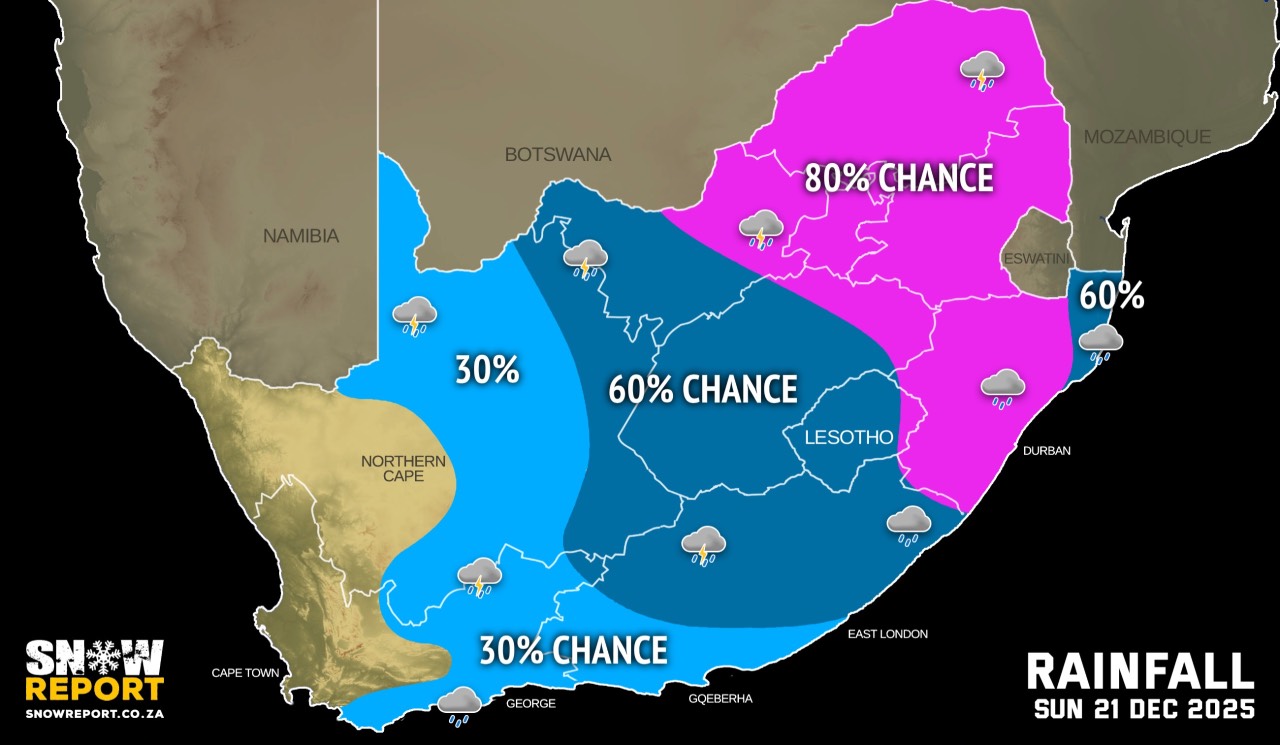
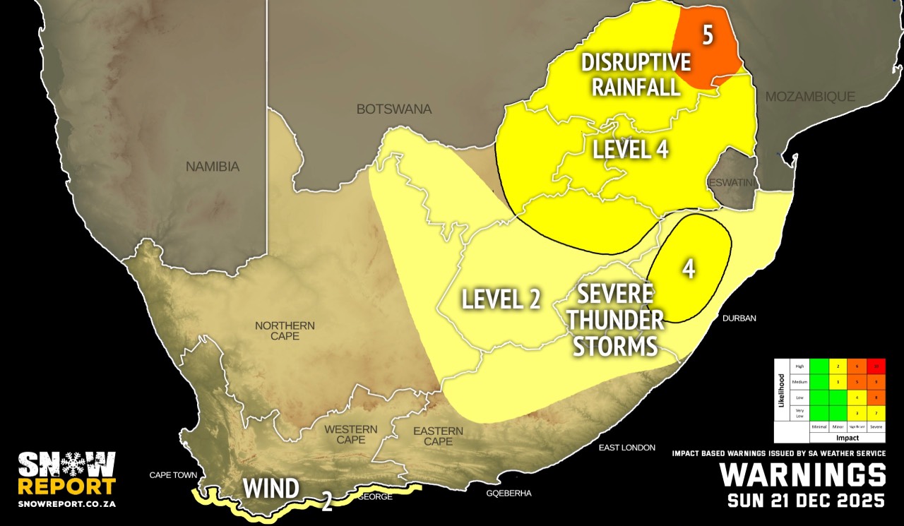
The latest forecast is available by clicking here. A continental tropical low which was situated over northern Botswana dissipated and released significant amounts of moisture over the eastern parts of South Africa. Persistent rainfall throughout the day will likely result in localised flooding – especially roads. Warnings from the SA Weather Service for Sunday: A. level 5 warning for disruptive rainfall over parts of Limpopo, as per the map above. B. level 4 warning for disruptive rainfall indicated for the whole of Gauteng, Mpumalanga and Limpopo, as well as parts of North West and the Free State leading to flooding of roads, formal and informal settlements as well as major disruption of traffic flow due to major roads being flooded or closed and possible damage to roads and bridges. Disruptions to municipal service, such as water and electricity are also possible. C. level 4 warning for severe thunderstorms leading to heavy downpours with flooding of susceptible roads, settlements and low-lying bridges, excessive lightning, strong damaging winds and large amounts of small hail and/or large hail over some populated areas in the western interior of KwaZulu-Natal. D. level 2 warning for severe thunderstorms leading to localised flooding of susceptible roads, settlements and low-lying bridges/areas, excessive lightning, strong damaging winds and large amounts of small hail and/or large hail over some populated areas in the extreme eastern parts of Northern Cape, Free State except in the north, as well as in places over KwaZulu-Natal, except in the western interior and parts of the Eastern Cape. E. level 2 warning for damaging winds leading to difficulty in navigation at sea and localised damage to temporary structures between Cape Point and Plettenberg Bay. Extremely high fire danger conditions are expected over the over the western parts of Northern Cape and the north-western part of Western Cape. Regional forecasts from the SA Weather Service for Sunday: GAUTENG Cloudy and cool to warm with scattered showers and thundershowers. MPUMALANGA Cloudy and cool to warm with widespread showers and thundershowers but scattered in the western Highveld. LIMPOPO Cloudy and cool to warm with scattered showers and thundershowers but widespread in the east. NORTH-WEST Cloudy and cool to warm with scattered showers and thundershowers. THE FREE STATE Cloudy and cool to warm with scattered showers and thundershowers. THE NORTHERN CAPE Fine in the extreme west with morning fog along the coast, otherwise partly cloudy and warm to hot with isolated showers to thundershowers but scattered in the extreme east. The wind along the coast will be moderate to fresh southerly to south-easterly. THE WESTERN CAPE Fine in the west, otherwise partly cloudy and hot to very hot with isolated showers and thundershowers in the east. It will be cool to warm along the south coast where light rain is expected. The wind along the coast will be moderate to fresh easterly along the south, otherwise strong south-easterly. THE WESTERN HALF OF THE EASTERN CAPE Partly cloudy and warm to hot with isolated to scattered showers and thundershowers. A 30% chance of light rain can be expected along the coast. The wind along the coast will be moderate to fresh easterly, reaching strong from the afternoon. THE EASTERN HALF OF THE EASTERN CAPE Cloudy and cool to warm with scattered showers and thundershowers, but isolated in the south-west. The wind along the coast will be moderate to fresh easterly, becoming fresh to strong north-easterly in the afternoon. KWAZULU-NATAL Morning fog over the southern interior, otherwise cloudy and cool to warm with widespread showers and thundershowers but scattered in the north-east where it will be partly cloudy. The wind along the coast will be light and variable in the south until late morning, otherwise moderate to fresh easterly to north-easterly. Travellers forecasts from the SA Weather Service for Sunday: PRETORIA Cloudy with scattered showers and thundershowers. Minimum/Maximum: 18/24°C JOHANNESBURG Cloudy with scattered showers and thundershowers. Minimum/Maximum: 16/23°C VEREENIGING Cloudy with scattered showers and thundershowers. Minimum/Maximum: 17/24°C MBOMBELA Cloudy with widespread showers and thundershowers. Minimum/Maximum: 18/22°C POLOKWANE Cloudy with scattered showers and thundershowers. Minimum/Maximum: 18/22°C MAHIKENG Cloudy with scattered showers and thundershowers. Minimum/Maximum: 18/24°C VRYBURG Cloudy with scattered showers and thundershowers. Minimum/Maximum: 18/26°C BLOEMFONTEIN Cloudy, with scattered showers and thundershowers. Minimum/Maximum: 16/25°C KIMBERLEY Cloudy with scattered afternoon showers and thundershowers. Minimum/Maximum: 18/29°C UPINGTON Partly cloudy with isolated showers and thundershowers. Minimum/Maximum: 22/34°C CAPE TOWN Fine. Wind: Moderate to fresh south-westerly. Minimum/Maximum: 20/33°C GEORGE Partly cloudy with a 30% chance of light rain. Wind: Moderate to fresh easterly. Minimum/Maximum: 14/24°C GQEBERHA Cloudy with isolated showers and rain. Wind: Fresh to strong easterly. Minimum/Maximum: 18/23°C EAST LONDON Cloudy with isolated showers and rain. Wind: Moderate to fresh easterly to north-easterly. Minimum/Maximum: 18/24°C DURBAN Cloudy with widespread showers and thundershowers. Wind: moderate to fresh north-easterly. Minimum/Maximum: 22/25°C RICHARDS BAY Partly cloudy with scattered showers and thundershowers. Wind: Light to moderate northerly to north-easterly. Minimum/Maximum: 22/27°C PIETERMARITZBURG Morning fog patches, otherwise cloudy with widespread showers and thundershowers. Minimum/Maximum: 18/24°C This forecast is usually updated a few times per day.
Please be sure to send photos and videos to us via whatsapp and also tell us where and when they were taken. Follow our channels
|