
TUESDAY WEATHER: Warnings for seven provinces and widespread rain in the north
By Staff WriterPublished: 20 April 2026
This forecast is for: Tue 21 April 2026
The maps cover: Tue 21 Apr – Tue 21 Apr
| SHARE TO |
The latest forecast is available by clicking here.
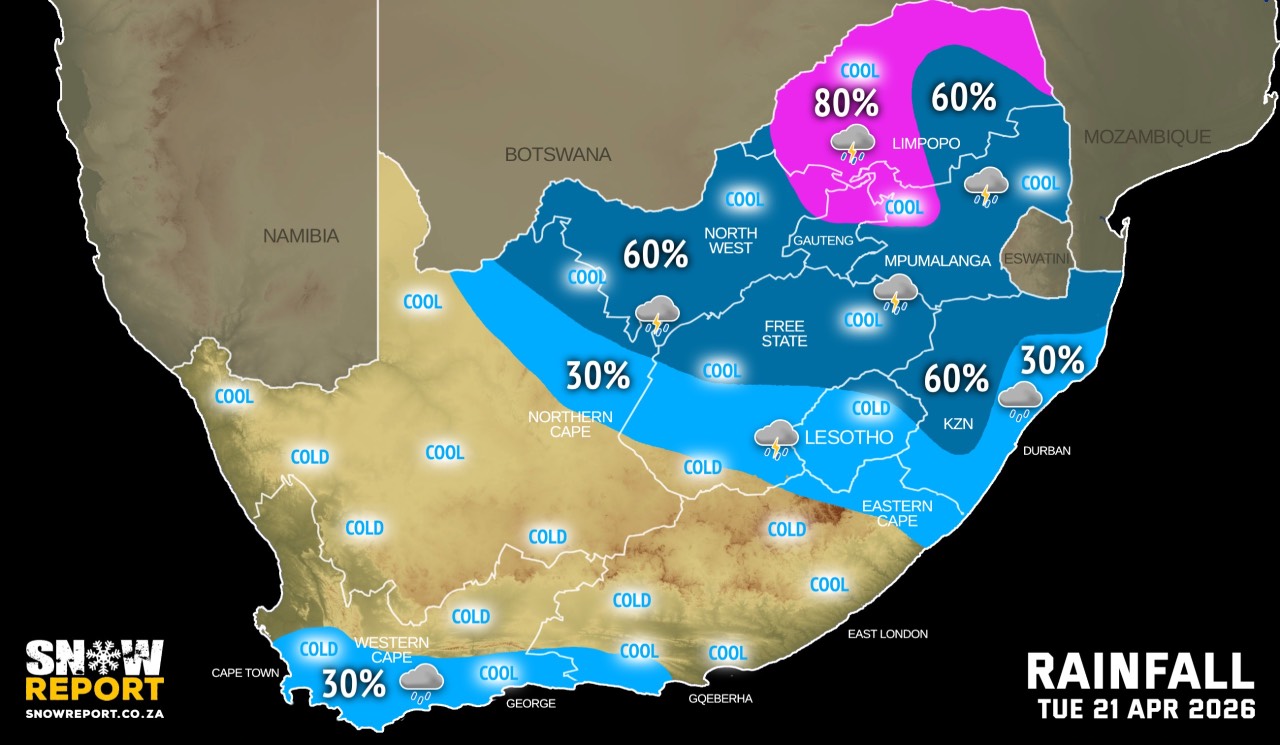
Widespread rainfall is indicated in the north-east of the country for the next few days.
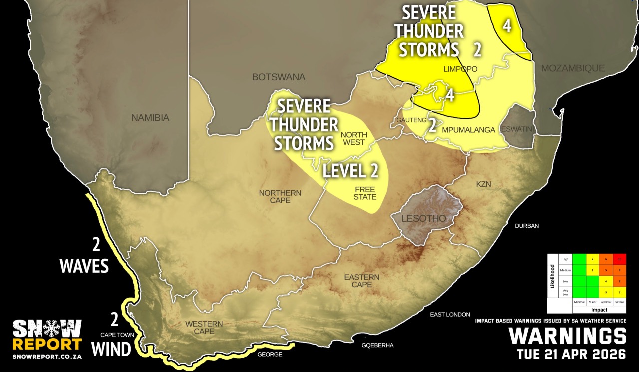
Warnings from the SA Weather Service for Tuesday:
A. level 4 warning for severe thunderstorms leading to strong damaging winds, hail, excessive lightning and possible heavy downpours leading to flooding and damages to susceptible formal/informal settlements and infrastructure over the eastern and south-western parts of Limpopo, northern parts of Gauteng, as well as the extreme north-western parts of Mpumalanga.
B. level 2 warning for severe thunderstorms leading to localised flooding of susceptible roads, low-lying areas and bridges, as well as localised damage to infrastructure and settlements (informal) over the central parts of Limpopo, Mpumalanga, southern parts of Gauteng, western and extreme eastern parts of the North West, as well as the western and central parts of the Free State.
C. level 2 warning for damaging winds and waves leading to disruption of ports/small harbours activities for a short period of time and difficulty in navigation at sea between Alexander Bay and Plettenberg Bay.
D. level 2 warning for damaging waves leading to disruption of ports/small harbours activities for a short period of time and difficulty in navigation at sea between Alexander Bay and Plettenberg Bay.
Regional forecasts from the SA Weather Service for Tuesday:
GAUTENG
Cloudy and warm with scattered showers and thundershowers but widespread in the northern parts.
MPUMALANGA
Morning fog along the escarpment, otherwise cloudy and cool with scattered showers and thundershowers, but widespread in the north-eastern highveld. It will be warm over the Lowveld.
LIMPOPO
Morning fog along the escarpment, otherwise cloudy and cool to warm with widespread showers and thundershowers but scattered over the central and south-eastern parts.
NORTH-WEST
Partly cloudy and cool to warm, with scattered showers and thundershowers.
THE FREE STATE
Partly cloudy and cool to warm, with scattered showers and thundershowers but isolated in the south.
THE NORTHERN CAPE
Fine and cool but partly cloudy in the north-east with isolated to scattered showers and thundershowers. The wind along the coast will be moderate to fresh southerly to south-easterly.
THE WESTERN CAPE
Fine over the eastern parts in the morning, otherwise partly cloudy to cloudy and cool to cold over the south-western and southern parts with afternoon rain. The wind along the coast will be moderate to fresh north-westerly in the morning otherwise westerly to south-westerly.
THE WESTERN HALF OF THE EASTERN CAPE
Fine and cool, becoming cloudy with isolated showers along the south coast in the evening. The wind along the coast will be fresh to strong westerly.
THE EASTERN HALF OF THE EASTERN CAPE
Fine and cool, but warm along the coast and adjacent interior, becoming partly cloudy with isolated thundershowers in the extreme east. The wind along the coast will be moderate to fresh north-easterly becoming south-westerly in the late afternoon.
KWAZULU-NATAL
Partly cloudy and warm, but hot in the north-east, becoming cloudy in the afternoon with isolated showers and thundershowers, but scattered in the west. The wind along the coast will be moderate to fresh easterly to north-easterly.
Travellers forecasts from the SA Weather Service for Tuesday:
PRETORIA
Cloudy with widespread showers and thundershowers.
Minimum/Maximum: 15/24°C
JOHANNESBURG
Cloudy with scattered showers and thundershowers.
Minimum/Maximum: 14/23°C
VEREENIGING
Cloudy with scattered showers and thundershowers.
Minimum/Maximum: 14/24°C
MBOMBELA
Morning fog, otherwise cloudy with scattered showers and thundershowers.
Minimum/Maximum: 18/25°C
POLOKWANE
Partly cloudy becoming cloudy with scattered showers and thundershowers.
Minimum/Maximum: 16/24°C
MAHIKENG
Partly cloudy with scattered showers and thundershowers.
Minimum/Maximum: 14/26°C
VRYBURG
Partly cloudy with scattered showers and thundershowers.
Minimum/Maximum: 9/26°C
BLOEMFONTEIN
Partly cloudy with isolated showers and thundershowers.
Minimum/Maximum: 8/21°C
KIMBERLEY
Partly cloudy with isolated showers and thundershowers.
Minimum/Maximum: 7/22°C
UPINGTON
Fine.
Minimum/Maximum: 7/24°C
CAPE TOWN
Partly cloudy becoming cloudy with rain from the afternoon.
Wind: Moderate to fresh north-westerly becoming south-westerly.
Minimum/Maximum: 12/17°C
GEORGE
Fine becoming partly cloudy to cloudy with rain from the afternoon
Wind: Light to moderate north-westerly in the morning becoming moderate to fresh south-westerly.
Minimum/Maximum: 10/20°C
GQEBERHA
Fine, becoming cloudy with showers of rain in the evening.
Wind: Fresh to strong westerly.
Minimum/Maximum: 13/23°C
EAST LONDON
Fine.
Wind: Moderate to fresh north-easterly becoming south-westerly in the late afternoon.
Minimum/Maximum: 14/24°C
DURBAN
Fine, becoming partly cloudy with isolated evening showers and thundershowers.
Wind: Moderate north-westerly becoming moderate to fresh north-easterly.
Minimum/Maximum: 21/28°C
RICHARDS BAY
Fine, becoming partly cloudy with isolated afternoon showers and thundershowers.
Wind: Light south-easterly, becoming moderate to fresh north-easterly.
Minimum/Maximum: 22/30°C
PIETERMARITZBURG
Fine, becoming partly cloudy with scattered afternoon showers and thundershowers.
Minimum/Maximum: 15/30°C
This forecast is usually updated a few times per day.
| SHARE TO |
Please be sure to send photos and videos to us via whatsapp and also tell us where and when they were taken.
Follow our channels