
  Swipe left or right for more maps, and see below for others
Rainfall in the forecast for eight provinces on Monday and snowfall possible this weekBy Staff WriterPublished: 20 April 2025 [updated 21 April] This forecast is for: Mon 21 April 2025 The maps cover: Mon 21 Apr – Wed 23 Apr
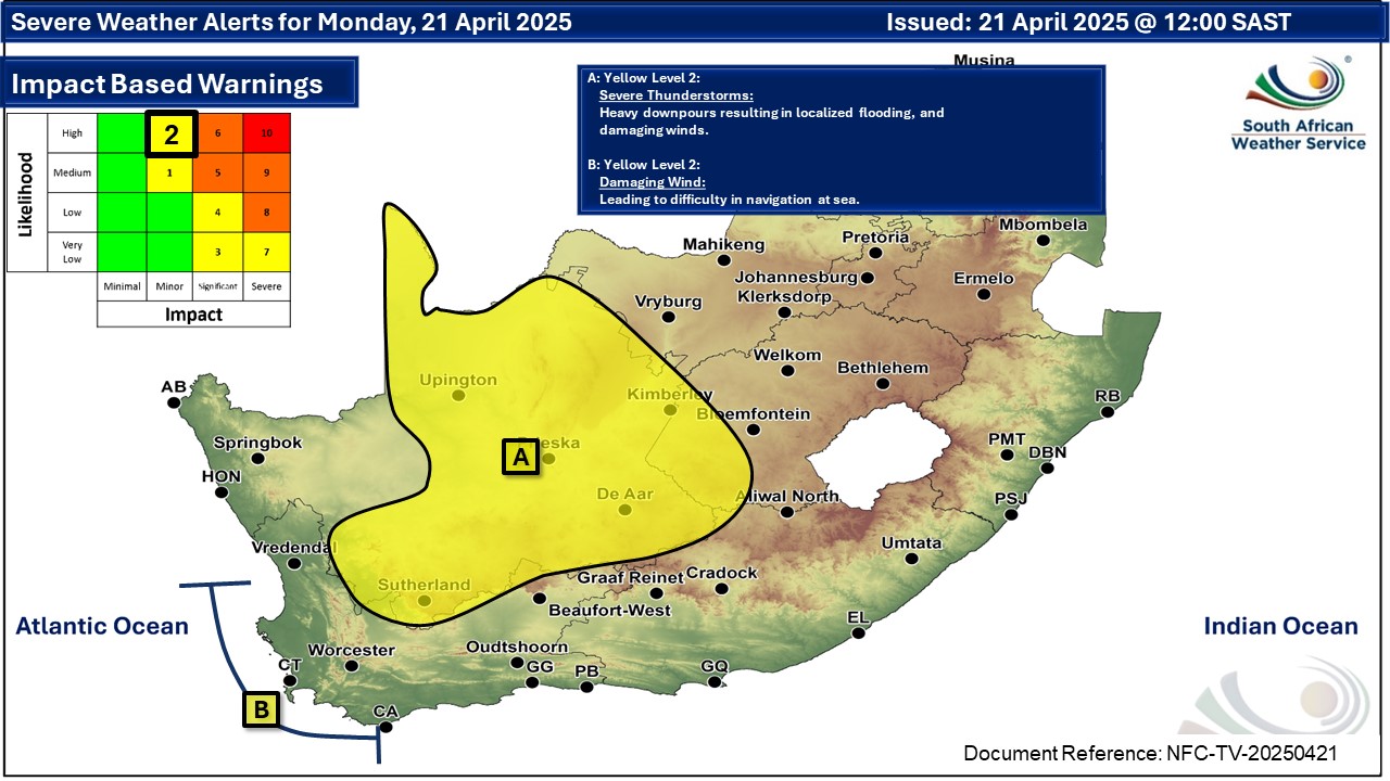
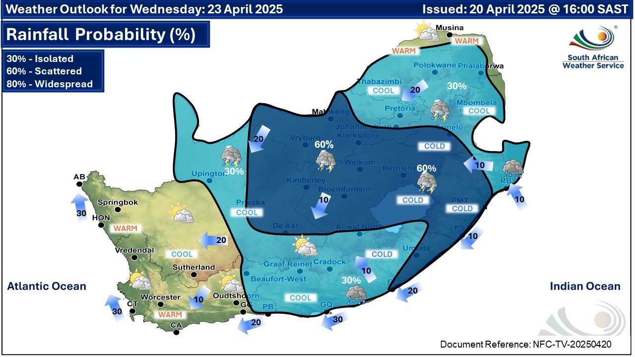
A newer forecast is available by clicking here. Isolated to scattered showers and thundershowers are expected over the central and eastern parts of the country, but widespread along the south-east coast on Tuesday, according to the SA Weather Service. From Tuesday it will be partly cloudy and warm to cool with isolated to scattered showers and thundershowers over the central and eastern parts of South Africa, but it will be cold in places in the south-eastern areas. SEE ALSO: Heavy snow possible in Lesotho from late Tuesday and through the week. Warnings from the SA Weather Service for Monday: A. yellow level 2 warning for severe thunderstorms leading to localised damage to settlements over an open area as well as localised flooding of susceptible roads, low-lying areas and bridges are expected over western parts of Free State and most parts of Northern Cape, except in the north-west. B. yellow level 2 warning for coastal winds leading to difficulty in navigation at sea are expected between Lambert's Bay and Hermanus. Warnings from the SA Weather Service for Tuesday: A. orange level 5 warning for disruptive rainfall over parts of the Eastern Cape, resulting in flooding of roads and settlements, difficult driving conditions and damage to roads, as per the map below. B. yellow level 2 warning for disruptive rainfall over parts of the Eastern Cape, resulting in localised flooding of roads and settlements, difficult driving conditions and damage to roads, as per the map below. C. yellow level 2 warning for severe thunderstorms over parts of the Northern Cape and the Free State, leading to heavy downpours and localised flooding as well as damaging winds, as per the map below. D. yellow level 2 warning for coastal winds leading to difficulty in navigation at sea along the Western Cape coast, as per the map below. Regional forecasts from SAWS for Monday: 1. GAUTENG Partly cloudy and cool with isolated showers and thundershowers over the southern parts. It will hot in the extremely hot. The expected UVB sunburn index: High 2. MPUMALANGA Partly cloudy and cool to warm with isolated showers and thundershowers in the south. 3. LIMPOPO Partly cloudy and cool to warm. 4. NORTH-WEST PROVINCE Partly cloudy and cool to warm with isolated to scattered showers and thundershowers, except the east. 5. FREE STATE Morning fog patches in the west and central parts, otherwise partly cloudy and cool with isolated showers and thundershowers, but scattered in the west where it will be cloudy. 6. NORTHERN CAPE Morning fog in the south-east, partly cloudy and cool to warm with isolated to scattered showers and thundershowers, except in the extreme north-west. The wind along coast will be fresh to strong southerly to south-easterly, becoming moderate in the evening. 7. WESTERN CAPE Fine and warm in the extremely west, otherwise partly cloudy and cool with isolated showers and thundershowers. Light rain can be expected along the south coast and adjacent interior where it will be cold. The wind along the coast will be moderate to fresh easterly to south-easterly along the south coast, reaching strong from the afternoon, otherwise fresh to strong southerly to south-easterly, reaching gale along the south-west coast at times. The expected UVB sunburn index: Moderate 8. WESTERN HALF OF THE EASTERN CAPE Cloudy and cold to cool with scattered showers and rain. The wind along the coast will be light to moderate south-easterly. 9. EASTERN HALF OF THE EASTERN CAPE Cloudy and cold to cool with scattered showers and thundershowers, but widespread in the south-west. The wind along the coast will be light south-westerly, becoming south-easterly in the afternoon. 10. KWAZULU-NATAL Morning fog over the central and western interior, otherwise partly cloudy and cool to warm with isolated to scattered showers and thundershowers. It will be cold in the south-west. The wind along the coast will be light to moderate northerly to north-westerly in the north until late morning, otherwise moderate to fresh north-easterly but south-westerly in the south. The expected UVB sunburn index: High Travellers forecasts from SAWS for Monday: PRETORIA Partly cloudy. Minimum/Maximum: 13/23°C The expected UVB Sunburn Index: High JOHANNESBURG Partly cloudy with isolated showers and thundershowers. Minimum/Maximum: 13/22°C VEREENIGING Partly cloudy with isolated showers and thundershowers. Minimum/Maximum: 10/23°C MBOMBELA Partly cloudy. Minimum/Maximum: 14/26°C POLOKWANE Partly cloudy. Minimum/Maximum: 13/26°C MAHIKENG Partly cloudy with isolated showers and thundershowers. Minimum/Maximum: 13/24°C VRYBURG Partly cloudy with scattered showers and thundershowers. Minimum/Maximum: 12/23°C BLOEMFONTEIN Cloudy with morning fog patches, otherwise partly cloudy with isolated showers and thundershowers. Minimum/Maximum: 11/21°C KIMBERLEY Cloudy with scattered showers and thundershowers. Minimum/Maximum: 12/23°C UPINGTON Cloudy with scattered showers and thundershowers. Minimum/Maximum: 15/26°C CAPE TOWN Fine and windy. Wind: Fresh to strong southerly to south-easterly. Minimum/Maximum: 17/20°C The expected UVB Sunburn Index: Moderate GEORGE Cloudy with light rain. Wind: Moderate to fresh easterly to south-easterly. Minimum/Maximum: 13/17°C GQEBERHA Cloudy with scattered showers and rain. Wind: Light to moderate south-easterly. Minimum/Maximum: 15/18°C EAST LONDON Cloudy with widespread showers and rain. Wind: Light south-easterly. Minimum/Maximum: 17/19°C DURBAN Partly cloudy with isolated showers and thundershowers. Wind: Light to moderate southerly to south-westerly. Minimum/Maximum: 19/25°C The expected UVB Sunburn Index: High RICHARDS BAY Partly cloudy with isolated showers and thundershowers. Wind: Light to moderate southerly to south-westerly. Minimum/Maximum: 17/26°C PIETERMARITZBURG Morning fog, otherwise partly cloudy to cloudy with scattered showers and thundershowers. Minimum/Maximum: 13/21°C This forecast is usually updated a few times per day.
Please be sure to send photos and videos to us via whatsapp and also tell us where and when they were taken. Follow our channels
Maps for Tuesday 22 April
 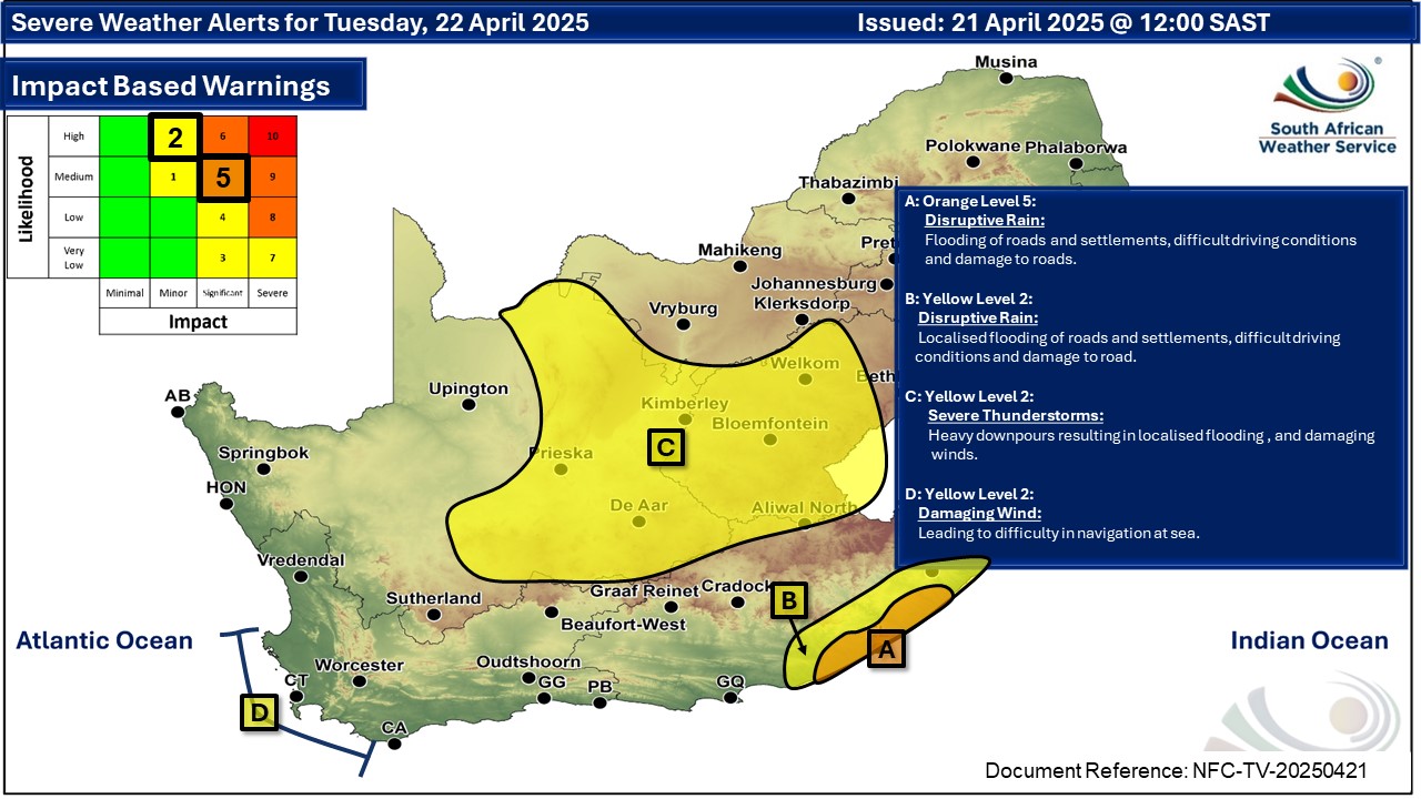 NOTE: The date on the SAWS warning map above should be Tuesday 22 April
Maps for Wednesday 23 April
|