
TUESDAY WEATHER: A foggy start with isolated showers and warnings for wind & waves in the east
 By Staff Writer
Published: 19 October 2026
This forecast is for: Tue 20 October 2026
The maps cover: Tue 20 Oct – Wed 21 Oct
| SHARE TO |
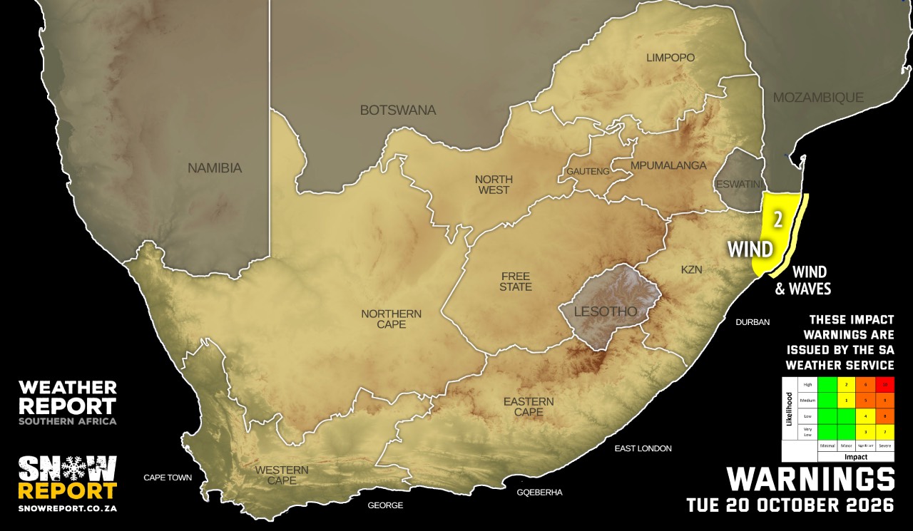
Warnings from the SA Weather Service:
A. level 2 warning for damaging winds and waves resulting in localised disruption of beachfront activities, as well as small harbours and/or ports along the north-coast of KwaZulu-Natal, mainly during the morning.
B. level 2 warning for damaging interior winds resulting in localised damages to settlements, problems for high sided vehicles on prone routes and risk of runaway fires over the extreme north-eastern parts of KwaZulu-Natal, mainly during the morning.
Extremely high fire danger conditions are expected over Karoo Hoogland local municipality in the Northern Cape, Central Karoo district municipality in the Western Cape, as well as Moretele local municipality in the North West.
Regional forecasts from the SA Weather Service:
GAUTENG
Fine, becoming partly cloudy and warm in the afternoon.
Check weather for Gauteng on myDorpie.
MPUMALANGA
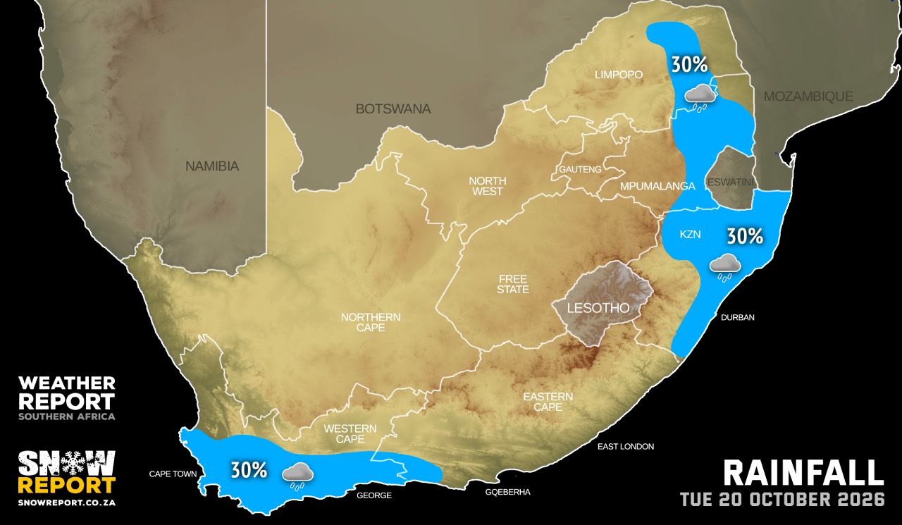
Cloudy in the east in the morning with a chance of light rain in places over the Lowveld and Escarpment, otherwise partly cloudy and cool to warm. Morning fog patches are also expected along the Escarpment.
Check weather for Mpumalanga on myDorpie.
LIMPOPO
Cloudy in the east in the morning with fog patches and drizzle in places along the Escarpment, otherwise partly cloudy and cool to warm, but fine in the Western Bushveld, where it will be hot in places.
Check weather for Limpopo on myDorpie.
NORTH-WEST
Fine and warm to hot.
Check weather for North West on myDorpie.
THE FREE STATE
Fine and cool to warm.
Check weather for the Free State on myDorpie.
THE NORTHERN CAPE
Fine and cool to warm with high-level clouds, becoming partly cloudy in the extreme south-west in the afternoon. The wind along the coast will be moderate to fresh southerly to south-easterly, reaching strong at first.
Check weather for the Northern Cape on myDorpie.
THE WESTERN CAPE
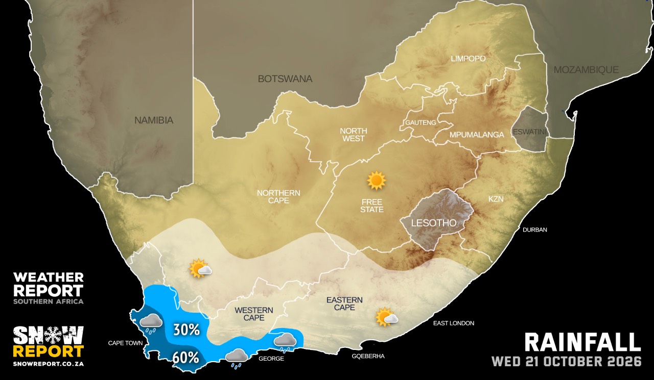
Warm in the north, otherwise fine and cool with high-level clouds. It will be partly cloudy over the extreme south-western parts, spreading to the rest of the province by the afternoon, whilst becoming cloudy with isolated showers and rain along the south-west and south coast, including the adjacent interior. The wind along the coast will be light to moderate northerly to north-westerly, but strong along the south-west coast. It will be moderate to fresh southerly to south-easterly north of Cape Columbine, but westerly to south-westerly from the afternoon.
Check weather for the Western Cape on myDorpie.
THE WESTERN HALF OF THE EASTERN CAPE
Partly cloudy in the north at first, otherwise fine and warm with high-level clouds, but cool in places along the coast. The wind along the coast will be moderate north-westerly, becoming easterly in the afternoon.
Check weather for the Eastern Cape on myDorpie.
THE EASTERN HALF OF THE EASTERN CAPE
Cloudy with fog in places in the north-east at first, otherwise fine and cool with high-level clouds. The wind along the coast will be moderate westerly, becoming north-easterly in the afternoon.
Check weather for the Eastern Cape on myDorpie.
KWAZULU-NATAL
Cloudy with morning fog over the interior, otherwise partly cloudy and cool to warm. Isolated morning showers and rain are expected in the north and along the coast. The wind along the coast will be moderate to fresh southerly to south-westerly, becoming light to moderate easterly to north-easterly south of Richards Bay in the afternoon spreading to Kosi Bay in the evening.
Check weather for KwaZulu-Natal on myDorpie.
This forecast is usually updated a few times per day.
| SHARE TO |
Please be sure to send photos and videos to us via whatsapp and also tell us where and when they were taken.
Follow our channels