
 More maps below the forecast
Five warnings including heavy rain and flooding due to cut-off low from Sunday19 October 2024 [updated 20 October]By Staff Writer
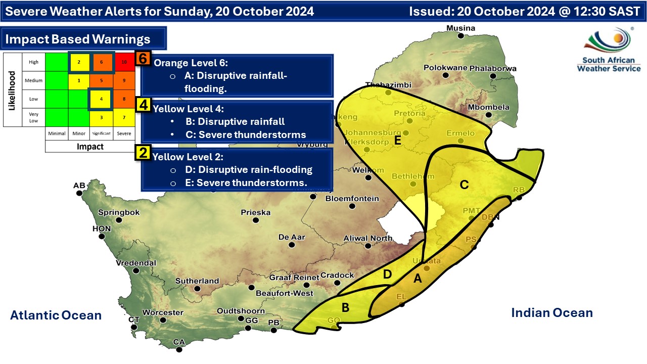
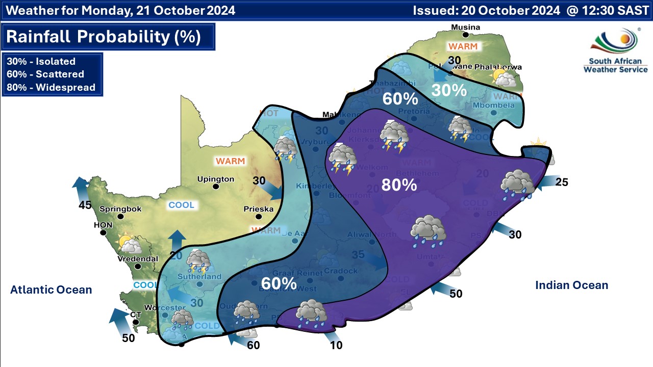
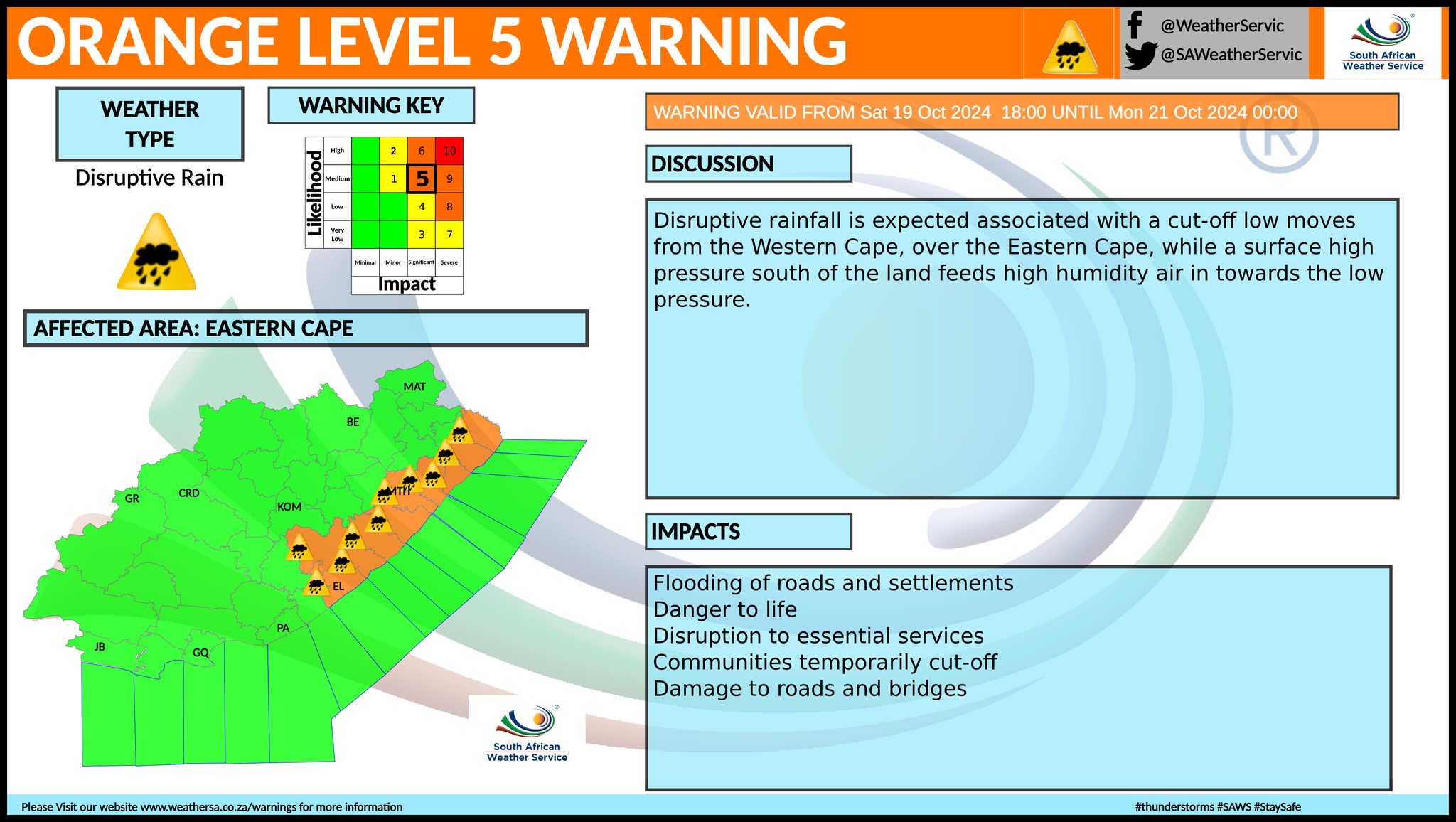
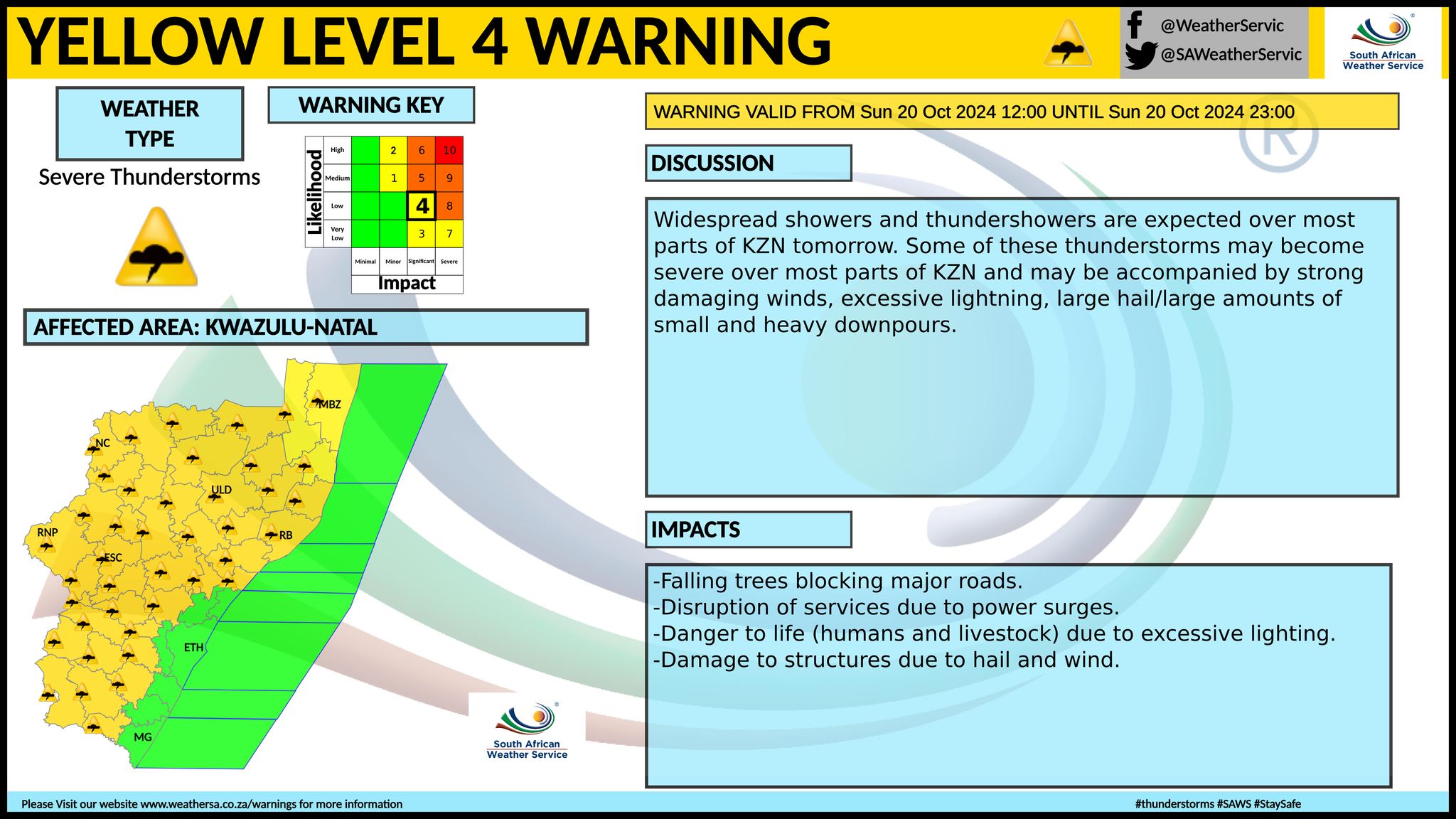
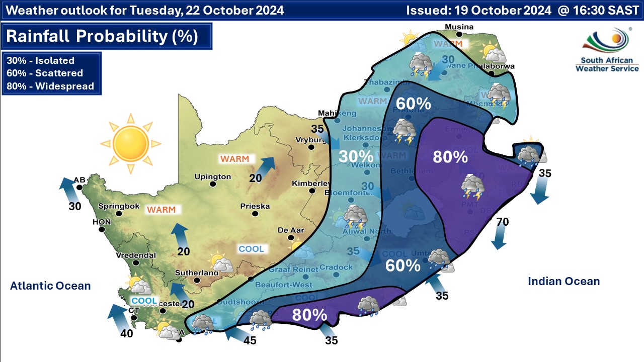
ALSO READ: Thunderstorms and a level 6 warning for disruptive rainfall into Tuesday. A cut-off low pressure system will impact the southern, central, and eastern provinces from Sunday until Tuesday according to the SA Weather Service. Significant rainfall in the order of 100-200 mm is expected along the eastern coastline of the country during this period. From Monday rain and thundershowers are expected over the central and eastern areas, with a possibility of disruptive rain along the east coast of the country as well as severe thunderstorms for the north eastern provinces. Warnings from the SA Weather Service (SAWS): A. Orange level 6 warning for disruptive rainfall is expected along the coast and adjacent interior between Port Alfred and Mtunzini until Monday resulting in flooding of roads and settlements, damage to infrastructure and mud-based houses as well as major disruption of traffic flow due to major roads being flooded or closed. B. yellow level 4 warning for severe thunderstorms is expected over most parts of KwaZulu Natal, extreme southern parts of Mpumalanga as well as the extreme eastern parts of Free State which may lead to damage to structures due to hail and wind, damage or loss of infrastructure, settlements (formal and informal), property, vehicles, livelihood and livestock until Monday. C. yellow level 4 warning for disruptive rain leading to localised flooding of settlements, roads, damage to property and infrastructure for the Nelson Mandela Bay Metro, Kouga, Sundays River Valley, Makana and Mdlambe, as well as Ngqushwa Local Municipality until Monday, but likely to persist until Tuesday. D. yellow level 2 warning for severe thunderstorms is expected over the extreme north-eastern parts of KwaZulu Natal, eastern Free State, eastern North West Province, Gauteng and the Highveld of Mpumalanga as well as extreme south-western parts of Limpopo which may lead to localised damage to infrastructure, settlements, vehicles, livelihood and livestock until Monday. E. yellow level 2 warning for disruptive rain leading to localised flooding of settlements, roads, damage to property and infrastructure south of the eastern escarpment in Eastern Cape until Monday. Extremely high fire danger conditions are expected over the extreme north-eastern parts of Northern Cape,in places in southern and eastern North West Province, north-western Free State as well as in places in central Limpopo. Regional forecasts from SAWS for Sunday: 1. GAUTENG Fine and warm to hot, becoming partly cloudy with scattered showers and thundershowers in the afternoon. The expected UVB sunburn index: High 2. MPUMALANGA Cloudy in the east, otherwise partly cloudy cool to warm with isolated showers and thunderstorms, except in the extreme north-east, but scattered to widespread over the Highveld. 3. LIMPOPO Cloudy in the east, otherwise partly cloudy and warm to hot with isolated showers and thundershowers in the west but scattered over the south-western Bushveld. 4. NORTH WEST Partly cloudy, windy and warm to hot, with isolated to scattered showers and thundershowers in the central and eastern parts. 5. FREE STATE Partly cloudy, windy and warm to hot, with isolated to scattered showers and thundershowers, except in the north-west, but widespread in the extreme east where morning fog can be expected. 6. EASTERN PARTS OF THE NORTHERN CAPE Partly cloudy, windy and cool to warm, with isolated showers and thundershowers over the south. It will be hot in the north-east. 6. NORTHERN CAPE Fine to partly cloudy and cool to warm but cloudy and cold over the southern parts with isolated afternoon showers and thundershowers. Wind along the coast will be fresh to strong southerly to south-easterly. 7. WESTERN CAPE Fine to partly cloudy and cool to warm but cloudy and cool to cold over the east and southern parts with isolated showers and thundershowers. The wind along the coast will be fresh easterly to south-easterly but strong southerly to south-easterly in the west and south-west. The expected UVB sunburn index: Very High 8. WESTERN HALF OF THE EASTERN CAPE Cloudy and cold to cool with scattered showers and rain but widespread along the coast. It will be partly cloudy and cool in the extreme north with isolated showers and thundershowers. The wind along the coast will be light to moderate south-westerly, becoming moderate to fresh easterly in the afternoon. 9. EASTERN HALF OF THE EASTERN CAPE Cloudy and cold with scattered showers and rain, but widespread along the coast and adjacent interior. The wind along the coast will be light to moderate easterly, becoming fresh in the evening and reaching strong in places overnight. 10. KWAZULU-NATAL Morning fog patches over the interior, otherwise cloudy and cool with widespread showers and thundershowers but scattered in the extreme north-east. The wind along the coast will be moderate to fresh easterly to South-easterly in the south, reaching strong in the afternoon but north-easterly in the north. The expected UVB sunburn index: Moderate Travellers forecasts from SAWS for Sunday: PRETORIA Fine, becoming partly cloudy with scattered showers and thundershowers in the afternoon. Minimum/Maximum: 15/33°C The expected UVB Sunburn Index: High JOHANNESBURG Fine, becoming partly cloudy with scattered showers and thundershowers in the afternoon. Minimum/Maximum: 13/30°C VEREENIGING Fine, becoming partly cloudy with scattered showers and thundershowers in the afternoon. Minimum/Maximum: 13/29°C MBOMBELA Cloudy with isolated showers and thundershowers. Minimum/Maximum: 14/27°C POLOKWANE Partly cloudy with isolated showers and thundershowers. Minimum/Maximum: 14/31°C MAHIKENG Partly cloudy, and windy, with isolated showers and thundershowers. Minimum/Maximum: 15/33°C VRYBURG Partly cloudy, and windy. Minimum/Maximum: 12/34°C BLOEMFONTEIN Fine at first, otherwise partly cloudy, and windy. Minimum/Maximum: 11/30°C KIMBERLEY Fine at first, otherwise partly cloudy, and windy. Minimum/Maximum: 11/32°C UPINGTON Fine and windy. Minimum/Maximum: 13/28°C CAPE TOWN Fine. Wind: Moderate to fresh south-easterly becoming strong in the afternoon. Minimum/Maximum: 14/20°C The expected UVB Sunburn Index: Very High GEORGE Cloudy with isolated showers and thundershowers. Wind: Light north-westerly in the early morning, otherwise moderate to fresh easterly to south-easterly. Minimum/Maximum: 10/18°C GQEBERHA Cloudy with widespread showers and rain. Wind: Light and variable at first, otherwise moderate to fresh easterly. Minimum/Maximum: 12/18°C EAST LONDON Cloudy with widespread showers and rain. Wind: Light to moderate easterly, becoming fresh in the evening Minimum/Maximum: 13/17°C DURBAN Cloudy with widespread showers and rain. Wind: Moderate to fresh easterly to south-easterly, becoming strong in the afternoon. Minimum/Maximum: 15/22°C The expected UVB Sunburn Index: Moderate RICHARDS BAY Cloudy with widespread showers and thundershowers. Wind: Moderate to fresh easterly to north-easterly, becoming strong in the afternoon. Minimum/Maximum: 19/24°C PIETERMARITZBURG Morning fog patches, otherwise cloudy with widespread showers and thundershowers. Minimum/Maximum: 13/18°C This forecast may change and updates issued more than once a day. Please be sure to send photos and videos to us via whatsapp and also tell us where and when they were taken. See below for a link to our whatsapp channel but since the link does not work in the instagram app you will need to send us a whatsapp message and we'll send you a link. Follow our channels
Standard users are welcome to use the standard sharing buttons on this page to share our content. It is NOT acceptable to download or screen grab for reposting. Other media and channels need to send us a request in order to embed or use of our forecasts, maps, as well as images and video from our users that we post (before doing so).
Issued on Sunday
       Issued on Saturday
    |