
  Swipe left or right for more maps, and see below for others
Heat wave advisory exended to Thursday and rainfall expected in the CapeBy Staff WriterPublished: 19 March 2025 [updated 20 March] This forecast is for: Thu 20 March 2025 The maps cover: Thu 20 Mar – Sat 22 Mar
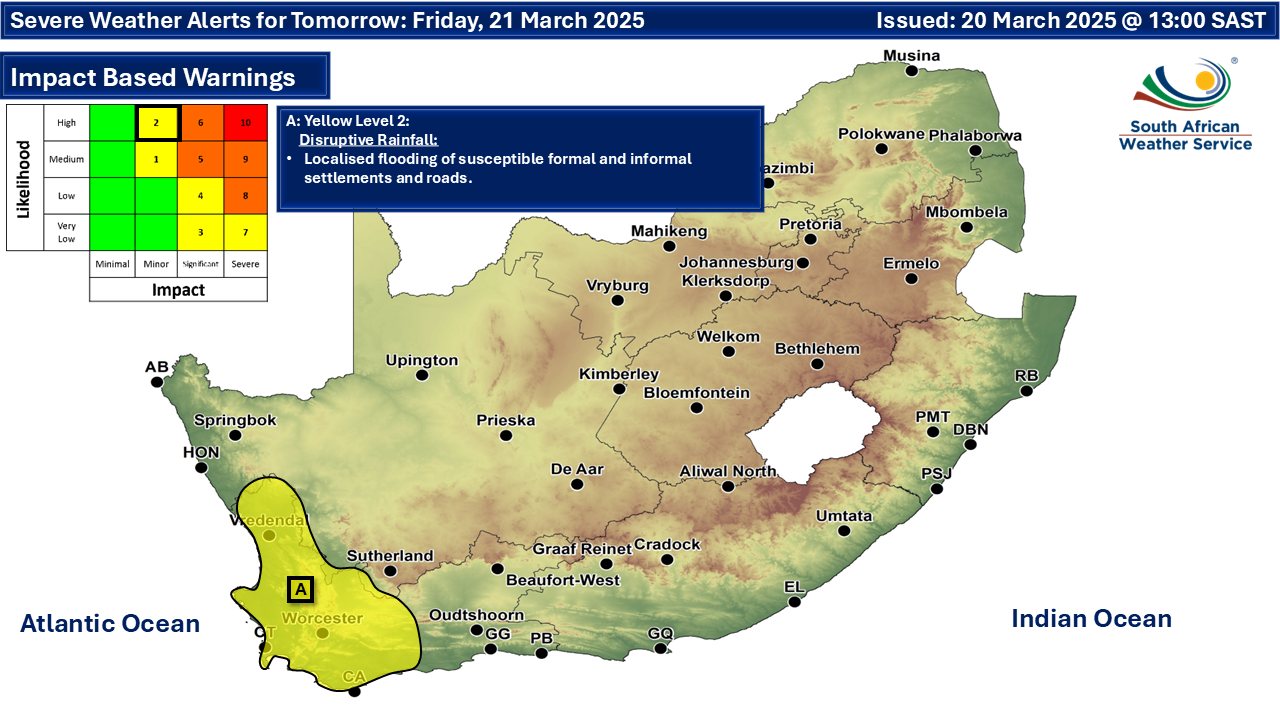
A newer forecast is available by clicking here. From Thursday and into Friday we see a higher probability of rainfall and thunderstorms on the radar for the west of the country, according to SA Weather. A heat wave with persistently high temperatures is expected in places over Alfred Nzo District of the Eastern Cape until Friday (A on the map above). Extremely uncomfortable conditions are expected over the interior of the Garden Route district municipality of the Western Cape as well as Sarah Baartman district municipality, spreading to the southeast coast and adjacent interior (Amatole, Buffalo City Metro and OR Tambo district municipalities) of the Eastern Cape. (B on the map above). Warnings from the SA Weather Service for Thursday: No impact warnings for Thursday at this stage. Extremely high fire danger conditions are expected over the Hantam local municipality in the Northern Cape, the Cederberg, Breede River Valley, Langeberg, Laingsburg, Prince Albert, Oudtshoorn and Hessequa local municipalities in the Western Cape, as well as Koukamma, Kouga, Sundays River Valley, Blue Crane Route, Dr Beyers Naude LMs and Nelson Mandela Bay Metro of the Eastern Cape. Regional forecasts from SAWS for Thursday: 1. GAUTENG Partly cloudy and cool with isolated afternoon showers and thundershowers. The expected UVB sunburn index: High 2. MPUMALANGA Partly cloudy and cool to warm with isolated showers and thundershowers. Morning fog is expected over the escarpment. 3. LIMPOPO Partly cloudy and cool to warm with isolated showers and thundershowers. 4. NORTH-WEST PROVINCE Partly cloudy and warm with isolated afternoon showers and thundershowers over the central and the eastern parts. 5. FREE STATE Partly cloudy and cool to warm with isolated showers and thundershowers over the central and the eastern parts. 6. NORTHERN CAPE Cloudy with isolated showers and thundershowers in the west, but scattered along the coast and adjacent interior, otherwise partly cloudy. It will be warm to hot, but very hot in places in the west and extremely hot in the south-west. The wind along the coast will be light and variable in the morning becoming moderate southerly to south-easterly in the afternoon. 7. WESTERN CAPE Morning fog in places along the west and south-west coast, otherwise partly cloudy and very hot with isolated showers and thundershowers, but scattered in the west, where it will be cloudy. The wind along the coast will be light to moderate easterly to south-easterly in the south but south-westerly along the west coast. The expected UVB sunburn index: High 8. WESTERN HALF OF THE EASTERN CAPE Warm in places along the coast, otherwise fine and hot to very hot, becoming partly cloudy in the afternoon. The wind along the coast will be light north-easterly, becoming moderate south-easterly in the afternoon. 9. EASTERN HALF OF THE EASTERN CAPE Fine and warm to hot. The wind along the coast will be light to moderate easterly to north-easterly. 10. KWAZULU-NATAL Morning fog over the interior, otherwise partly cloudy and cool to warm with isolated showers and rain in the north-eastern parts. The wind along the coast will be moderate to fresh northerly to north-easterly. The expected UVB sunburn index: Extreme Travellers forecasts from SAWS for Thursday: PRETORIA Partly cloudy with isolated afternoon showers and thundershowers. Minimum/Maximum: 15/22°C The expected UVB Sunburn Index: High JOHANNESBURG Partly cloudy with isolated afternoon showers and thundershowers. Minimum/Maximum: 13/21°C VEREENIGING Partly cloudy with isolated afternoon showers and thundershowers. Minimum/Maximum: 14/21°C MBOMBELA Partly cloudy with isolated showers and thundershowers. Minimum/Maximum: 17/23°C POLOKWANE Partly cloudy with isolated showers and thundershowers. Minimum/Maximum: 13/21°C MAHIKENG Partly cloudy with isolated afternoon showers and thundershowers. Minimum/Maximum: 16/26°C VRYBURG Partly cloudy. Minimum/Maximum: 17/27°C BLOEMFONTEIN Partly cloudy. Minimum/Maximum: 16/29°C KIMBERLEY Partly cloudy. Minimum/Maximum: 19/30°C UPINGTON Partly cloudy. Minimum/Maximum: 22/31°C CAPE TOWN Morning fog, otherwise cloudy with scattered showers and thundershowers in the afternoon. Wind: Light to moderate south-westerly. Minimum/Maximum: 21/26°C The expected UVB Sunburn Index: High GEORGE Partly cloudy with isolated showers and thundershowers. Wind: Light to moderate easterly to south-easterly. Minimum/Maximum: 18/30°C GQEBERHA Partly cloudy. Wind: light north-easterly, becoming moderate south-easterly in the afternoon. Minimum/Maximum: 18/29°C EAST LONDON Fine. Wind: Light to moderate easterly to north-easterly. Minimum/Maximum: 20/30°C DURBAN Partly cloudy. Wind: Moderate to fresh northerly to north-easterly. Minimum/Maximum: 20/28°C The expected UVB Sunburn Index: Extreme RICHARDS BAY Partly cloudy. Wind: Moderate to fresh northerly to north-easterly. Minimum/Maximum: 20/30°C PIETERMARITZBURG Morning fog patches, otherwise partly cloudy. Minimum/Maximum: 14/28°C This forecast is usually updated a few times per day.
Please be sure to send photos and videos to us via whatsapp and also tell us where and when they were taken. Follow our channels
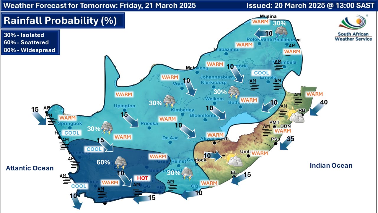
Maps for Friday 21 March
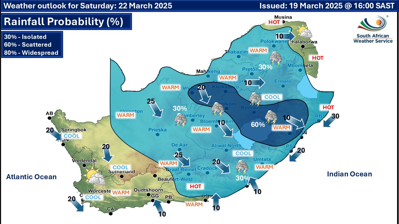
  Maps for Saturday 22 March
|