
TUESDAY WEATHER: Rain in the southern part of the country and a LEVEL 8 warning for Wednesday
By Staff WriterPublished: 1 June 2026
This forecast is for: Tue 02 June 2026
The maps cover: Tue 02 Jun – Wed 03 Jun
| SHARE TO |
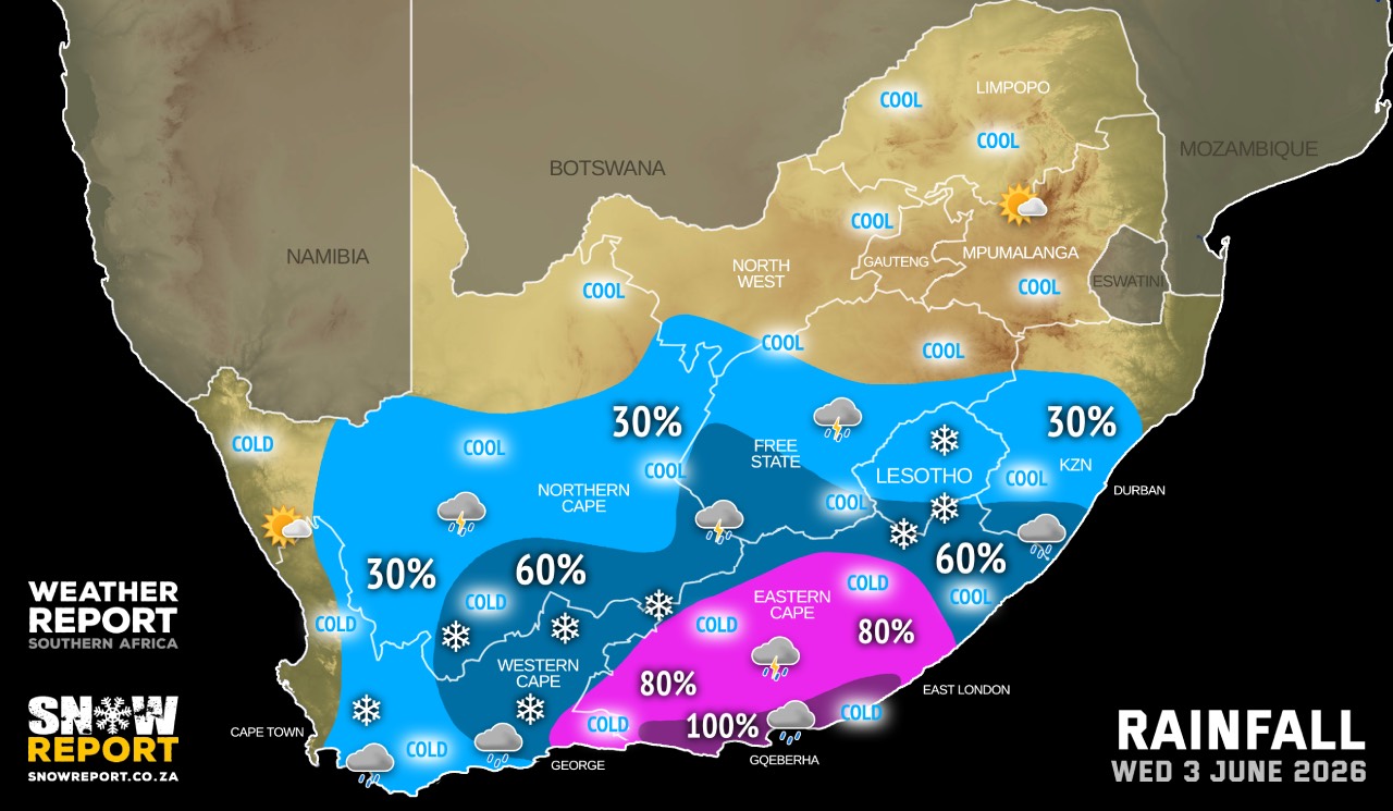
An intense cut off low is expected to affect the Eastern Cape from Wednesday to Friday, and according to the SA Weather Service a combination of snow, heavy rain, flooding, very cold conditions and very rough seas can be expected.
A cut-off low is also expected to affect the eastern parts of the Western Cape on Wednesday and Thursday. Two-day rainfall accumulations of 50-90mm can be expected over the Central Karoo, the western parts of the Garden Route districts and the Swellendam municipality, while 150-200mm is possible over the eastern Garden Route district, with higher accumulations in the mountainous regions.
Given the current vulnerability of these regions following the severe weather system in May, as well as the near full or overflowing dams, significant impacts are possible.
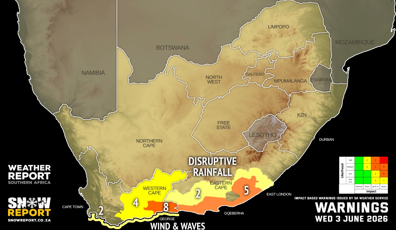
Warnings from the SA Weather Service:
A. level 8 warning for disruptive rain leading to danger to life , widespread flooding and displacement of settlements as well as mudslides is expected in places along the coast and adjacent interior between Mossel Bay and Plettenberg Bay in the Western Cape On Wednesday and Thursday.
B. level 5 warning for disruptive rain leading to danger to life, flooding and displacements of settlements as well as mudslides is expected in places along the coast and adjacent interior between Plettenberg Bay and East London in the Western and Eastern Cape on Wednesday and Thursday.
C. level 4 warning for disruptive rain leading to danger to life, flooding and displacements of settlements as well as mudslides is expected over the eastern parts of the Central Karoo and the western parts of the Garden Route Districts and the Swellendam Municipality on Wednesday and Thursday.
D. level 2 warning for disruptive rain leading to localised flooding of settlements, roads, low lying areas and bridges is expected in places over the southern parts of the Eastern Cape on Wednesday and Thursday.
E. level 2 warning for damaging wind and waves Leading to difficulty in navigation at sea as well as small vessels taking on water is expected between Cape Point and Plettenberg Bay on Wednesday and Thursday.
SEE ALSO: Snow possible in five SA provinces and Lesotho from Wednesday until the weekend.
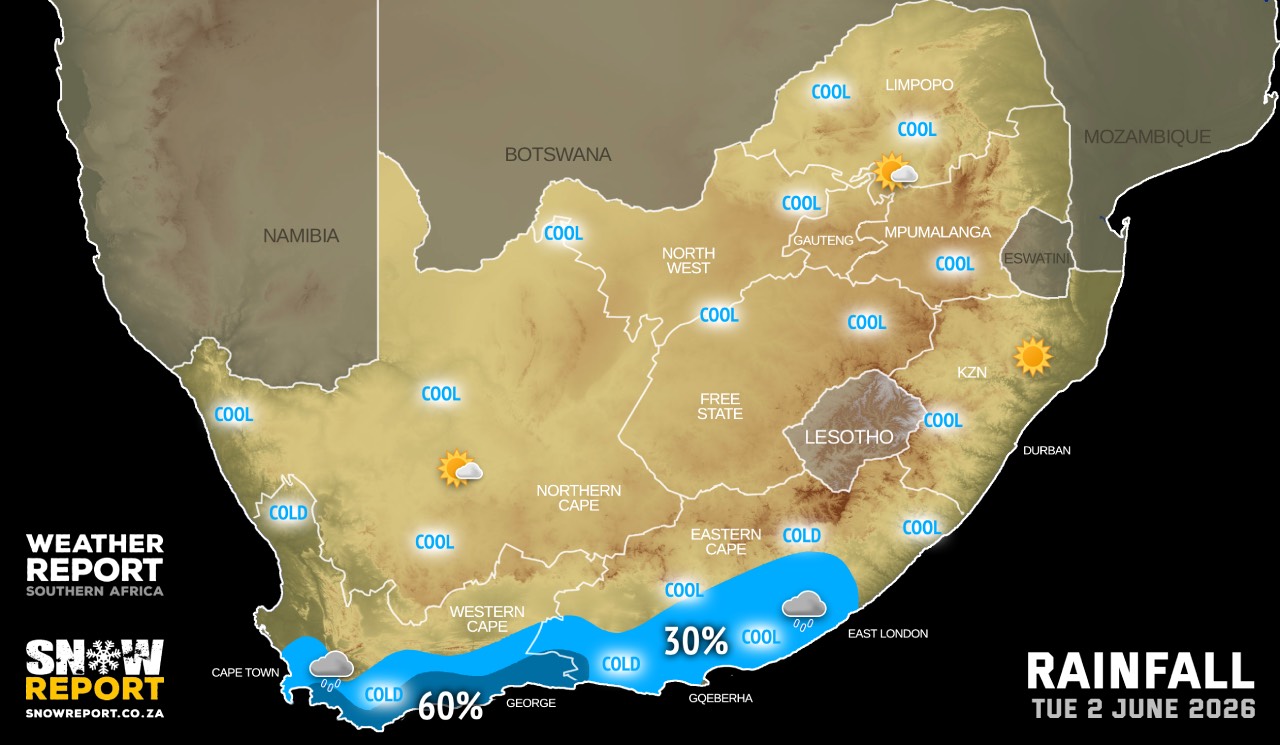
Regional forecasts from the SA Weather Service for Tuesday:
GAUTENG
Partly cloudy and cool.
MPUMALANGA
Fine and cool, but warm in the Lowveld.
LIMPOPO
Partly cloudy and cool to warm.
NORTH-WEST
Fine and cool, becoming partly cloudy in the afternoon.
THE FREE STATE
Fine and cool, becoming partly cloudy in the afternoon.
THE NORTHERN CAPE
Morning fog along the coast, otherwise partly cloudy and cool. It will be fine in places in the northern interior. The wind along the coast will be light to moderate southerly to south-easterly.
THE WESTERN CAPE
Cloudy to partly cloudy and cool, with isolated to scattered rain and showers over the southern parts from mid-morning. The wind along the coast will be moderate to fresh westerly to north-westerly, becoming moderate to fresh southerly to south-easterly from the afternoon.
THE WESTERN HALF OF THE EASTERN CAPE
Cloudy with mist in places along the coast and adjacent interior in the morning, otherwise fine and cool becoming cloudy with isolated showers in the south but scattered along the coast. The wind along the coast will be Fresh to strong south-westerly.
THE EASTERN HALF OF THE EASTERN CAPE
Fine and cool to warm, becoming cloudy with isolated showers in the south by evening. The wind along the coast will be Light north-westerly, becoming moderate south-westerly.
KWAZULU-NATAL
Fine and warm, but cool in the south-west parts. The wind along the coast will be light north-westerly, becoming moderate northerly to north-easterly towards midday. It will become moderate south-westerly south of Durban in the evening.
Travellers forecasts from the SA Weather Service for Tuesday:
PRETORIA
Partly cloudy.
Minimum/Maximum: 06/20°C
JOHANNESBURG
Partly cloudy.
Minimum/Maximum: 07/19°C
VEREENIGING
Partly cloudy.
Minimum/Maximum: 05/18°C
MBOMBELA
Fine.
Minimum/Maximum: 10/22°C
POLOKWANE
Partly cloudy.
Minimum/Maximum: 06/21°C
MAHIKENG
Fine, becoming partly cloudy in the afternoon.
Minimum/Maximum: 09/21°C
VRYBURG
Fine, becoming partly cloudy in the afternoon.
Minimum/Maximum: 10/22°C
BLOEMFONTEIN
Fine, becoming partly cloudy.
Minimum/Maximum: 09/21°C
KIMBERLEY
Fine, becoming partly cloudy.
Minimum/Maximum: 11/22°C
UPINGTON
Fine.
Minimum/Maximum: 14/24°C
CAPE TOWN
Cloudy with isolated rain from mid-morning.
Wind: Light to moderate north-westerly, becoming moderate south-easterly from the afternoon.
Minimum/Maximum: 13/20°C
GEORGE
Cloudy with scattered rain from the afternoon
Wind: Light to moderate northerly to north-westerly in the morning, otherwise light to moderate south-easterly.
Minimum/Maximum: 14/19°C
GQEBERHA
Partly cloudy with isolated showers at night.
Wind: Light to moderate north-westerly, becoming south-westerly in the afternoon.
Minimum/Maximum: 17/20°C
EAST LONDON
Partly cloudy, becoming cloudy with isolated showers in the evening.
Wind: Light north-westerly at first, otherwise moderate south-westerly.
Minimum/Maximum: 19/23°C
DURBAN
Fine.
Wind: Moderate north-easterly.
Minimum/Maximum: 17/24°C
RICHARDS BAY
Fine.
Wind: Moderate northerly to north-easterly.
Minimum/Maximum: 14/27°C
PIETERMARITZBURG
Fine.
Minimum/Maximum: 10/26°C
This forecast is usually updated a few times per day.
| SHARE TO |
Please be sure to send photos and videos to us via whatsapp and also tell us where and when they were taken.
Follow our channels