
   Swipe left or right for more maps, and see below for others
Disruptive rainfall and severe thunderstorms in the east on WednesdayBy Staff WriterPublished: 18 March 2025 [updated 19 March] This forecast is for: Wed 19 March 2025 The maps cover: Wed 19 Mar – Fri 21 Mar
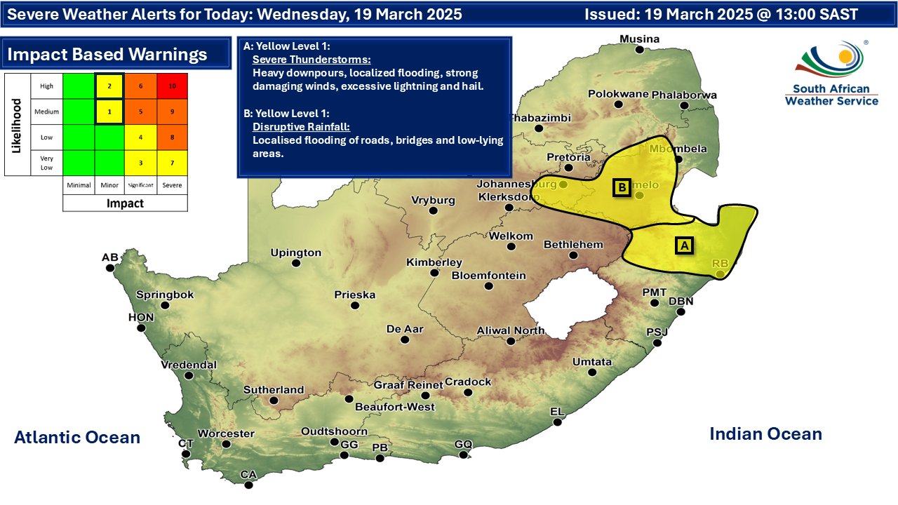
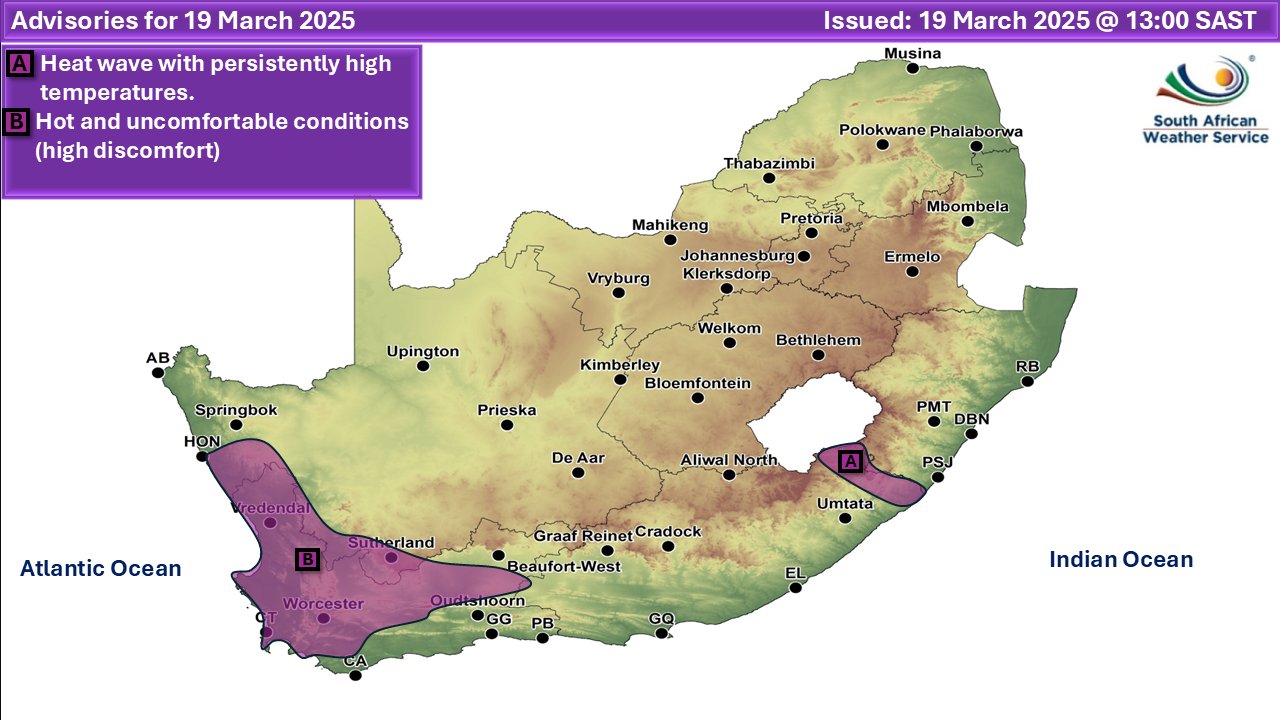
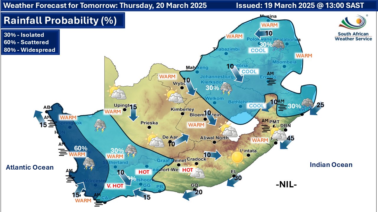
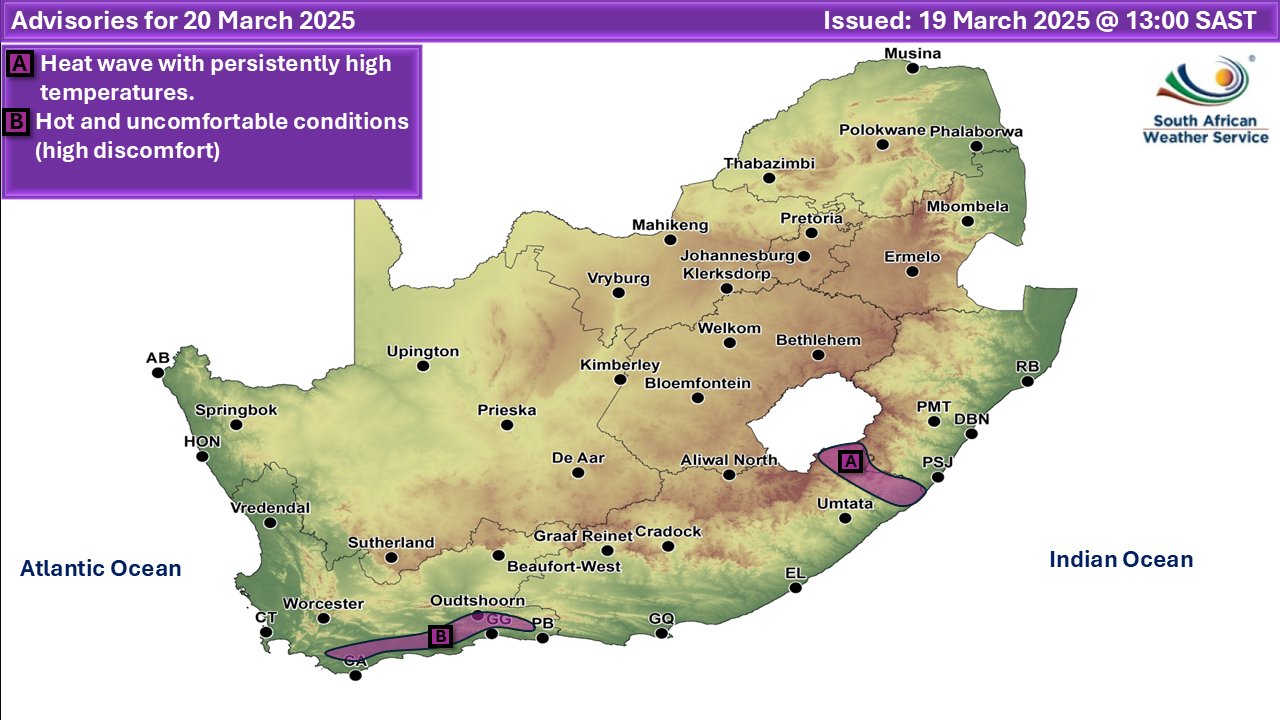
A newer forecast is available by clicking here. From Wednesday it is expected to be partly cloudy and warm, but it will be cool in the east with isolated to scattered showers and thundershowers over the western and eastern parts of the country, according to SA Weather. A Heat Wave with persistently high temperatures is expected in places over Alfred Nzo District of the Eastern Cape until Friday (A on the map above). Extremely uncomfortable conditions are expected over the interior and south-western coast of the Western Cape, and the south-western parts of the Northern Cape (B on the map above). From Thursday and into Friday we see a higher probability of rainfall and thunderstorms on the radar for the west of the country. Warnings from the SA Weather Service for Wednesday: A. yellow level 1 warning severe thunderstorms with possible strong winds, heavy downpours, hail and excessive lightning, resulting in localised flooding of susceptible areas and localised damage to infrastructure, settlements, property, vehicles, livelihood and livestock are expected over the northern parts of KwaZulu-Natal. B. yellow level 1 warning disruptive rainfall leading to localised flooding of roads and settlements and damage to infrastructure is expected over the southern parts of Gauteng as well as the Highveld and escarpment of Mpumalanga. Extremely high fire danger conditions are expected in places over the western and north-eastern parts of the Western Cape as well as the coast and adjacent interior of the Northern Cape. Regional forecasts from SAWS for Wednesday: 1. GAUTENG Morning fog in places, otherwise cloudy and cool with scattered showers and thundershowers but isolated in the north. The expected UVB sunburn index: Moderate 2. MPUMALANGA Morning fog expected in places along the escarpment, otherwise cloudy and cool to warm with scattered showers and thundershowers. 3. LIMPOPO Morning fog expected in places along the escarpment, otherwise cloudy and cool to warm with isolated showers and thundershowers. 4. NORTH-WEST PROVINCE Morning fog patches over the southern parts, otherwise partly cloudy and warm, with isolated showers and thundershowers over the central and the eastern parts. 5. FREE STATE Cloudy with morning fog patches over the east and along the Lesotho border at first, otherwise partly cloudy and cool to warm, with isolated showers and thundershowers over the central and the eastern parts but Scattered showers and thundershowers in the extreme east. 6. NORTHERN CAPE Fine in the south-west, otherwise partly cloudy and warm to hot, but very hot in places in the west. Isolated showers and thundershowers are expected over the extreme western parts from the afternoon. The wind along the coast will be moderate easterly to southeasterly becoming fresh southerly in the afternoon. 7. WESTERN CAPE Morning fog patches along the south coast, otherwise fine and warm to hot but very hot over the interior and extremely hot over the western coastal regions. It will become partly cloudy over the southwestern parts from the afternoon with mist along the coastal regions. The wind along the coast will be moderate to fresh easterly to south-easterly. The expected UVB sunburn index: Very High 8. WESTERN HALF OF THE EASTERN CAPE Fine and warm, but hot over the interior. The wind along the coast will be moderate north-easterly 9. EASTERN HALF OF THE EASTERN CAPE Fine and warm. Evening fog is expected along the Wild Coast and adjacent interior. The wind along the coast will be moderate to fresh northeasterly 10. KWAZULU-NATAL Morning fog in places over the interior, otherwise cloudy and cool to warm with isolated showers and thundershowers but scattered in the north. It will be partly cloudy in the extreme south. The wind along the coast will be moderate to fresh easterly to north-easterly, but strong along the south coast. The expected UVB sunburn index: Moderate Travellers forecasts from SAWS for Wednesday: PRETORIA Cloudy with isolated showers and thundershowers. Minimum/Maximum: 15/24°C The expected UVB Sunburn Index: Moderate JOHANNESBURG Cloudy with scattered showers and thundershowers. Minimum/Maximum: 13/21°C VEREENIGING Cloudy with scattered showers and thundershowers. Minimum/Maximum: 14/24°C MBOMBELA Morning Fog, otherwise cloudy with isolated showers and thundershowers. Minimum/Maximum: 17/22°C POLOKWANE Partly cloudy with isolated showers and thundershowers. Minimum/Maximum: 14/22°C MAHIKENG Partly cloudy, with isolated showers and thundershowers. Minimum/Maximum: 16/26°C VRYBURG Partly cloudy. Minimum/Maximum: 17/27°C BLOEMFONTEIN Partly cloudy. Minimum/Maximum: 16/26°C KIMBERLEY Partly cloudy. Minimum/Maximum: 19/30°C UPINGTON Partly cloudy. Minimum/Maximum: 22/31°C CAPE TOWN Fine becoming partly cloudy in the afternoon with possible mist early evening. Wind: Light to moderate southerly to south-easterly. Minimum/Maximum: 21/33°C The expected UVB Sunburn Index: Very High GEORGE Cloudy with morning fog patches becoming partly cloudy but fine by the afternoon. Wind: Moderate to fresh easterly to south-easterly. Minimum/Maximum: 18/30°C GQEBERHA Fine Wind: Moderate north-easterly. Minimum/Maximum: 19/26°C EAST LONDON Fine Wind: Moderate north-easterly. Minimum/Maximum: 20/28°C DURBAN Cloudy with isolated showers and thundershowers. Wind: Moderate to fresh northerly to north-easterly, reaching strong at times. Minimum/Maximum: 21/28°C The expected UVB Sunburn Index: Moderate RICHARDS BAY Cloudy with scattered showers and thundershowers. Wind: Moderate to fresh northerly to north-easterly. Minimum/Maximum: 21/29°C PIETERMARITZBURG Morning fog patches, otherwise cloudy with isolated showers and thundershowers. Minimum/Maximum: 14/28°C This forecast is usually updated a few times per day.
Please be sure to send photos and videos to us via whatsapp and also tell us where and when they were taken. Follow our channels
Maps for Thursday 20 March
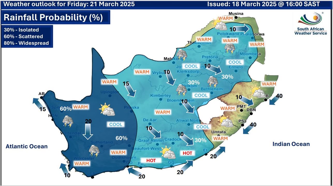
  Maps for Friday 21 March
|