
   Swipe left or right for more maps, and see below for others
Cold in the interior on Saturday and a disruptive rainfall warning for KwaZulu-NatalBy Staff WriterPublished: 18 July 2025 [updated 19 July] This forecast is for: Sat 19 July 2025 The maps cover: Sat 19 Jul – Mon 21 Jul
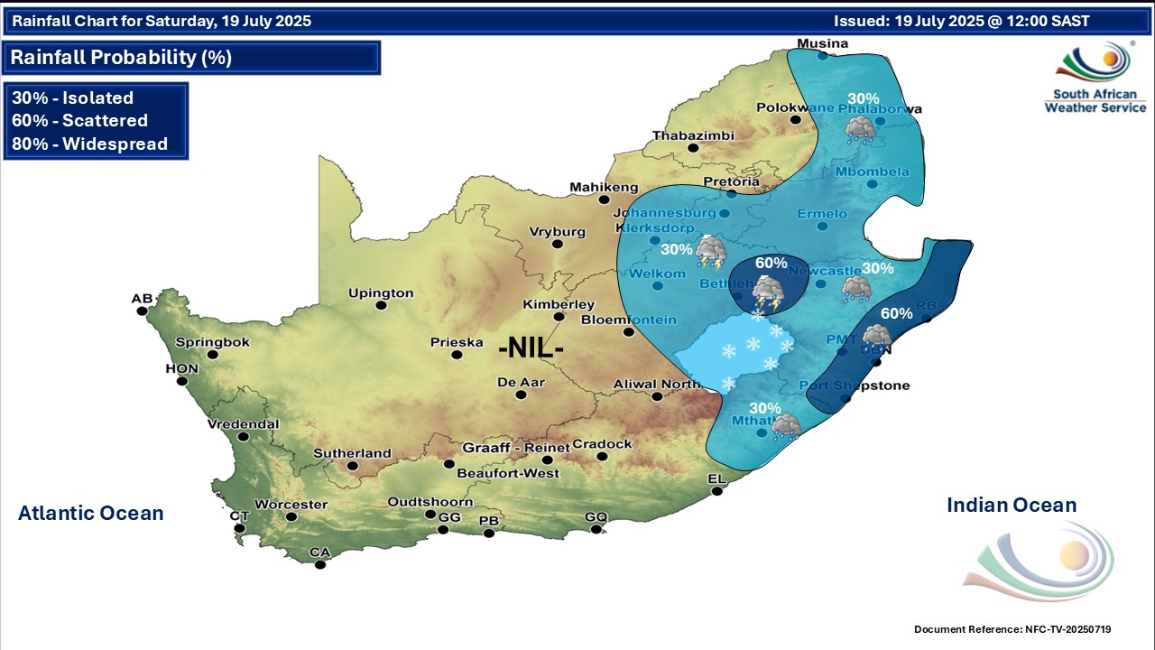
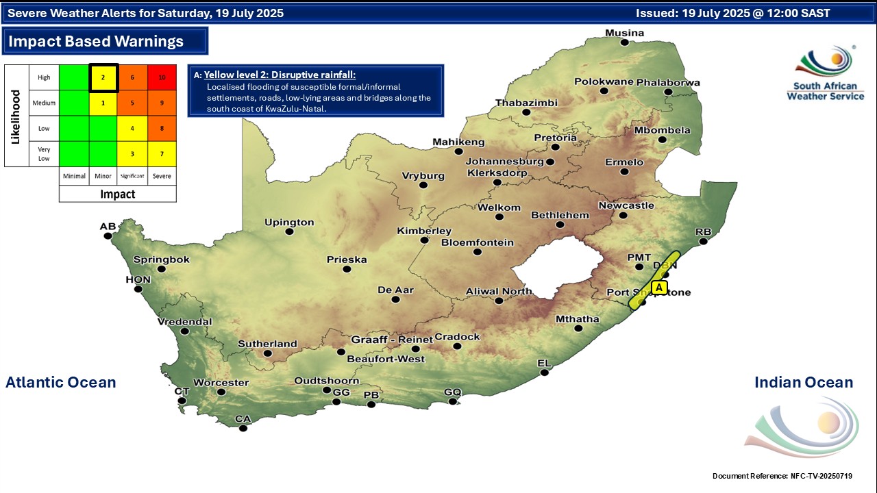
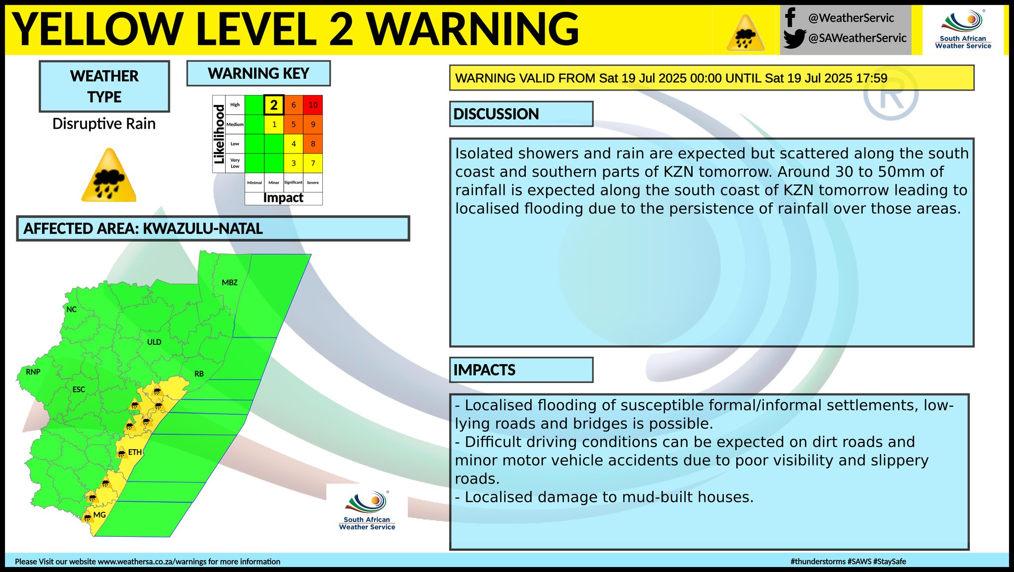
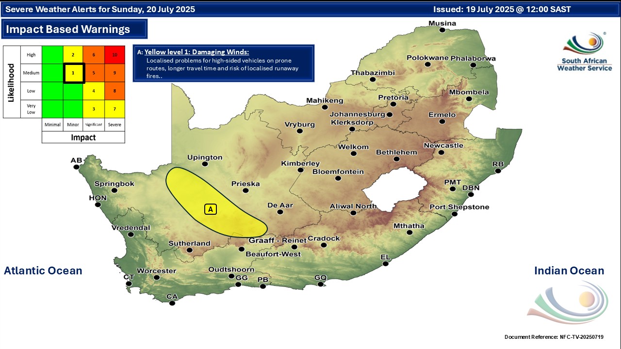
A newer forecast is available by clicking here. You can listen to this daily weather forecast as a 4 minute podcast by pressing the > play button above. Around 30 to 50mm of rainfall is expected along the south coast of KwaZulu-Natal on Saturday leading to localised flooding due to the persistence of rainfall over those areas. ALSO READ: More snowfall possible for South Africa and Lesotho over the next few days. Warnings from the SA Weather Service for Saturday: A. level 2 warning for disruptive rainfall leading to localised flooding of susceptible formal/informal settlements or roads, low-lying areas and bridges and difficult driving conditions on dirt roads along the south coast of KwaZulu-Natal. Warnings from the SA Weather Service for Sunday: A. level 1 warning for damaging wind over parts of the Northern Cape, as per the map below. Regional forecasts from the SA Weather Service for Saturday: 1. GAUTENG Cloudy in the south at first, otherwise partly cloudy and cool with light rain, clearing in the evening. The expected UVB sunburn index: High 2. MPUMALANGA Morning fog along the escarpment, otherwise cloudy and cool to cold with isolated showers, except in the Lowveld where it will be warm. 3. LIMPOPO Cloudy and cool with drizzle along the escarpment, but warm in the Limpopo Valley. It will be partly cloudy in the south-western Bushveld. 4. NORTH-WEST PROVINCE Partly cloudy and cool with isolated showers and thundershowers in the south-east. 5. FREE STATE Partly cloudy and cold to cool with isolated showers and thundershowers in the east but scattered in the extreme east. 6. NORTHERN CAPE Fine and cool to cold, but warm in the north-west. The wind along the coast will be moderate to fresh easterly to south-easterly. 7. WESTERN CAPE Morning fog patches over the northern high ground, otherwise fine and cool to cold. The wind along the coast will be light to moderate south-easterly, but easterly to north-easterly along the south coast. The expected UVB sunburn index: Low 8. WESTERN HALF OF THE EASTERN CAPE Partly cloudy in places at first, otherwise fine and cold, but cool in places along the coast. The wind along the coast will be moderate to fresh north-easterly. 9. EASTERN HALF OF THE EASTERN CAPE Cloudy and cold with isolated showers and rain east of East London, but scattered along Wild Coast, becoming partly cloudy in the afternoon. The wind along the coast will be moderate to fresh north-easterly. 10. KWAZULU-NATAL Morning fog patches, otherwise cloudy and cold to cool with isolated showers, but scattered showers and rain along the coast and adjacent interior. The wind along the coast will be moderate to fresh easterly to south-easterly becoming light to moderate northerly to north-westerly in the south by the evening. The expected UVB sunburn index: Low Travellers forecasts from the SA Weather Service for Saturday: PRETORIA Partly cloudy with light rain, clearing in the evening. Minimum/Maximum: 8/20°C The expected UVB Sunburn Index: High JOHANNESBURG Cloudy at first, otherwise partly cloudy with light rain, clearing in the evening. Minimum/Maximum: 8/19°C VEREENIGING Cloudy at first, otherwise partly cloudy with light rain, clearing in the evening. Minimum/Maximum: 6/17°C MBOMBELA Cloudy with isolated showers. Minimum/Maximum: 9/21°C POLOKWANE Cloudy. Minimum/Maximum: 6/20°C MAHIKENG Partly cloudy. Minimum/Maximum: 6/20°C VRYBURG Partly cloudy. Minimum/Maximum: 1/22°C BLOEMFONTEIN Partly cloudy. Minimum/Maximum: 3/19°C KIMBERLEY Partly cloudy. Minimum/Maximum: 0/21°C UPINGTON Fine. Minimum/Maximum: 2/25°C CAPE TOWN Fine. Wind: Light and variable, becoming light to moderate south-easterly in the afternoon. Minimum/Maximum: 9/19°C The expected UVB Sunburn Index: Low GEORGE Fine. Wind: Light to moderate easterly to north-easterly. Minimum/Maximum: 5/18°C GQEBERHA Fine. Wind: Light northerly, becoming moderate to fresh north-easterly. Minimum/Maximum: 10/19°C EAST LONDON Cloudy in the morning, otherwise fine. Wind: Light north-westerly, becoming moderate to fresh north-easterly. Minimum/Maximum: 13/19°C DURBAN Cloudy with scattered showers and rain. Wind: Moderate to fresh easterly to south-easterly becoming light to moderate northerly to north-westerly by the evening. Minimum/Maximum: 14/20°C The expected UVB Sunburn Index: Low RICHARDS BAY Cloudy with scattered showers and rain. Wind: Moderate to fresh easterly to south-easterly. Minimum/Maximum: 15/20°C PIETERMARITZBURG Morning fog patches, otherwise cloudy with scattered showers and rain. Minimum/Maximum: 8/15°C This forecast is usually updated a few times per day.
Please be sure to send photos and videos to us via whatsapp and also tell us where and when they were taken. Follow our channels
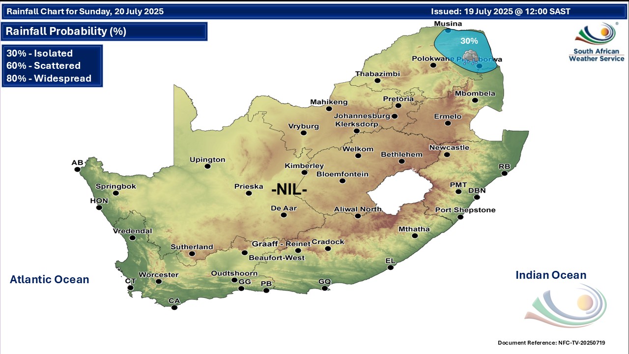
Maps for Sunday 20 July
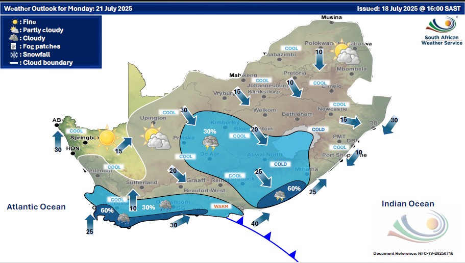
  Maps for Monday 21 July
|