
MONDAY WEATHER: Warning upgraded to Level 5 for Limpopo and damaging coastal winds expected
By Staff WriterPublished: 18 January 2026 [updated 19 January]
This forecast is for: Mon 19 January 2026
The maps cover: Mon 19 Jan – Mon 19 Jan
| SHARE TO |
The latest forecast is available by clicking here.
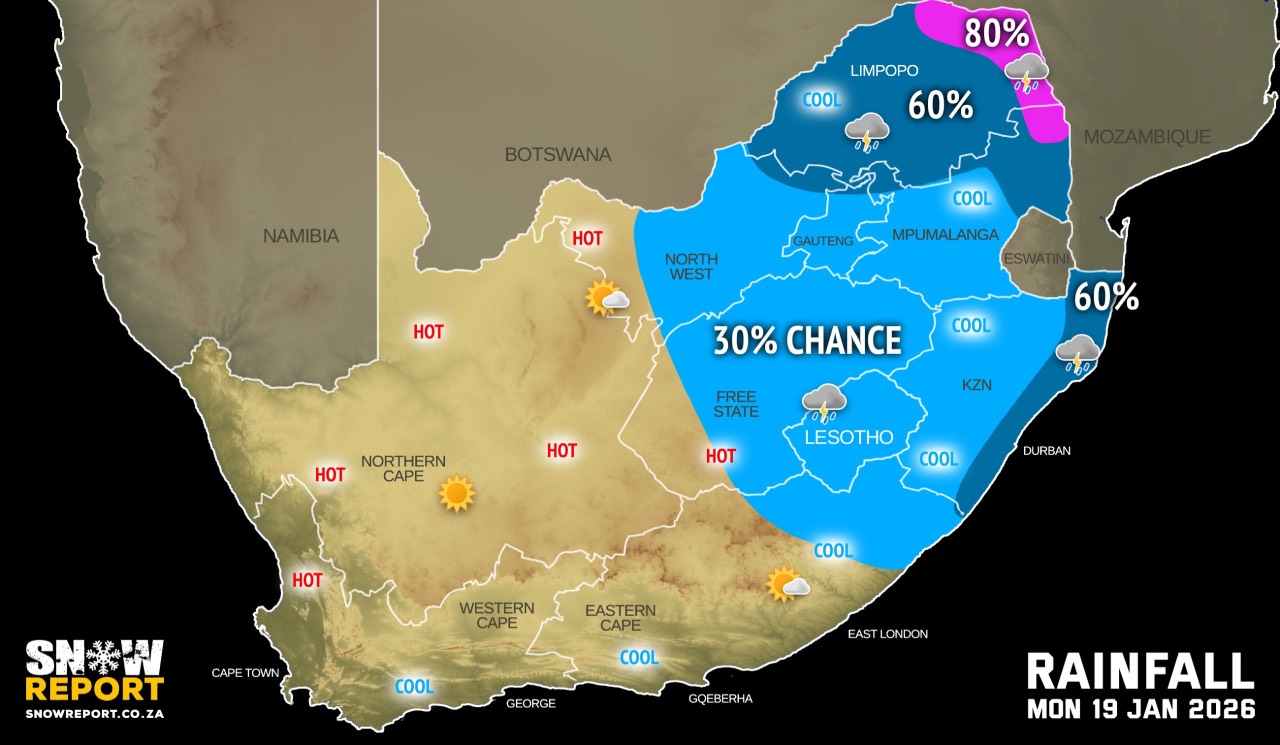
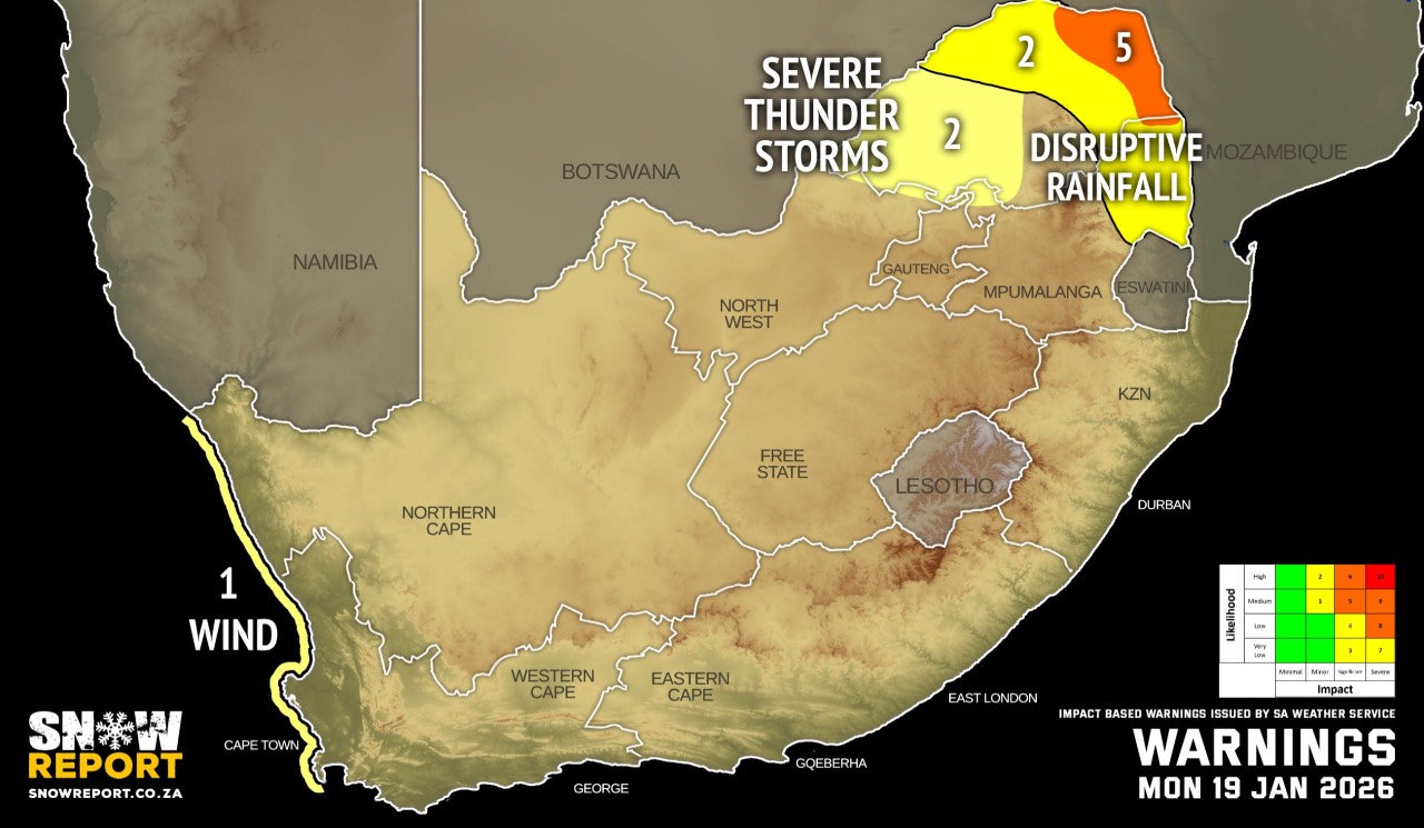
A level 5 warning with a medium likelihood of significant impacts was added on Monday morning for the Lowveld of Limpopo as well as the eastern parts of the Limpopo Valley due to persistent overnight rainfall with 30-60mm more expected during the course of Monday.
From Tuesday it should be partly cloudy and cool to warm with isolated to scattered showers and thundershowers possible, mainly over the eastern and central regions, while other areas remain mostly dry.
Hot to very hot conditions can be expected over the western parts of the country with some areas reaching extremely hot temperatures.
Warnings from the SA Weather Service for Monday:
level 5 warning for disruptive rainfall over parts Limpopo, including Musina and Collins Chabane local municipalities. This warning was added on Monday morning.
A. level 2 warning for disruptive rainfall with heavy downpours leading to localised flooding of susceptible roads, settlements, low-lying bridges/areas, major roads affected but can be used, increased travel times over the eastern and northern parts of Limpopo.
B. level 2 warning for severe thunderstorms with localised flooding of susceptible roads, low-lying areas and bridges, large amounts of small hail, and localised damage to infrastructure due to damaging winds over the south-western parts of Limpopo.
C. level 1 warning for damaging coastal winds resulting in difficulty in navigation at sea between Alexander Bay and Cape Columbine on Monday morning spreading to Cape Point from the afternoon.
Extremely high fire danger conditions are expected over the north-eastern parts of Northern Cape.
Regional forecasts from the SA Weather Service for Monday:
GAUTENG
Cloudy and cool to warm, becoming partly cloudy in the afternoon.
MPUMALANGA
Partly cloudy over the Highveld at first, otherwise cloudy and cool to warm with isolated showers and thundershowers, but scattered in the extreme north-west.
LIMPOPO
Cloudy and warm with scattered showers and thundershowers, but isolated in extreme south-east.
NORTH-WEST
Partly cloudy and warm to hot, with isolated showers and thundershowers in the central and eastern parts, but scattered in the extreme east where it will be cloudy.
THE FREE STATE
Morning fog patches in the east, otherwise partly cloudy and warm to hot with isolated showers and thundershowers, except in the extreme north-west.
THE NORTHERN CAPE
Fine and warm to hot, but cool over Richtersveld Municipality. The wind along the coast will be fresh to strong southerly to south-easterly.
THE WESTERN CAPE
Partly cloudy in the central and eastern parts at first, otherwise fine and cool to warm but hot over the northern parts of west coast. It will become partly cloudy along the south coast from the evening. The wind along the coast will be light south-westerly along the south coast, otherwise fresh to strong southerly to south-easterly.
THE WESTERN HALF OF THE EASTERN CAPE
Partly cloudy, becoming fine and warm. The wind along the coast will be light to moderate south-westerly.
THE EASTERN HALF OF THE EASTERN CAPE
Partly cloudy in the west at first, otherwise cloudy and cool to warm with light rain along the wild coast and adjacent interior, but with isolated thunderstorms in the north-east interior. The wind along the coast will be light south-westerly turning southerly to south-easterly along the northern coastline.
KWAZULU-NATAL
Cloudy and cool to warm with isolated showers and thundershowers but scattered along the coast and adjacent interior. The wind along the coast will be moderate to fresh southerly to south-westerly but strong north of Richards Bay.
Travellers forecasts from the SA Weather Service for Monday:
PRETORIA
Cloudy, becoming partly cloudy in the afternoon.
Minimum/Maximum: 16/26°C
JOHANNESBURG
Cloudy, becoming partly cloudy in the afternoon.
Minimum/Maximum: 15/24°C
VEREENIGING
Cloudy, becoming partly cloudy in the afternoon.
Minimum/Maximum: 15/26°C
MBOMBELA
Cloudy with isolated showers and thundershowers.
Minimum/Maximum: 19/24°C
POLOKWANE
Cloudy with scattered showers and thundershowers.
Minimum/Maximum: 19/24°C
MAHIKENG
Partly cloudy with isolated showers and thundershowers.
Minimum/Maximum: 18/31°C
VRYBURG
Partly cloudy.
Minimum/Maximum: 14/34°C
BLOEMFONTEIN
Fine, becoming partly cloudy with isolated afternoon showers and thundershowers.
Minimum/Maximum: 15/33°C
KIMBERLEY
Fine, becoming partly cloudy in the afternoon.
Minimum/Maximum: 16/34°C
UPINGTON
Fine.
Minimum/Maximum: 15/35°C
CAPE TOWN
Fine.
Wind: Moderate to fresh southerly to south-easterly.
Minimum/Maximum: 15/24°C
GEORGE
Cloudy, becoming partly cloudy in the afternoon.
Wind: Light and variable, but moderate southerly in the afternoon.
Minimum/Maximum: 16/22°C
GQEBERHA
Fine.
Wind: Light to moderate south-westerly.
Minimum/Maximum: 14/26°C
EAST LONDON
Partly cloudy, becoming cloudy.
Wind: Light south-westerly.
Minimum/Maximum: 15/25°C
DURBAN
Cloudy with scattered showers and rain.
Wind: Moderate to fresh southerly to south-westerly reaching strong in the afternoon.
Minimum/Maximum: 17/24°C
RICHARDS BAY
Cloudy with scattered showers and rain.
Wind: Moderate to fresh southerly to south-westerly reaching strong to near gale in the afternoon.
Minimum/Maximum: 18/25°C
PIETERMARITZBURG
Cloudy with isolated showers and thundershowers.
Minimum/Maximum: 11/22°C
This forecast is usually updated a few times per day.
| SHARE TO |
Please be sure to send photos and videos to us via whatsapp and also tell us where and when they were taken.
Follow our channels