
        Swipe left or right for more maps, and see below for others
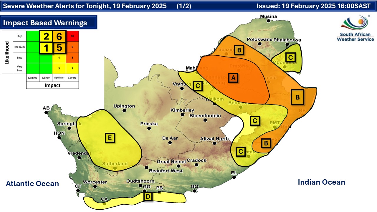
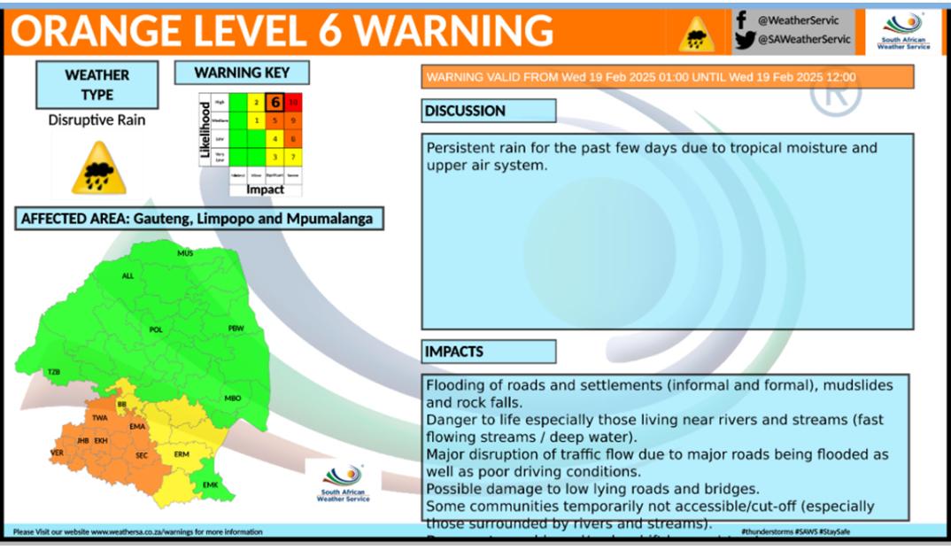
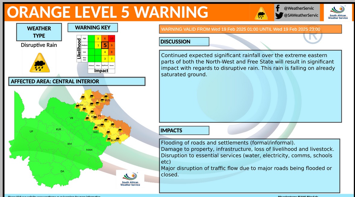
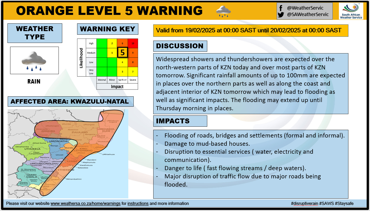
Rain across most of South Africa on Wednesday and level 6 and 5 warningsBy Staff WriterPublished: 18 February 2025 [updated 19 February] This forecast is for: Wed 19 February 2025 The maps cover: Wed 19 Feb – Fri 21 Feb
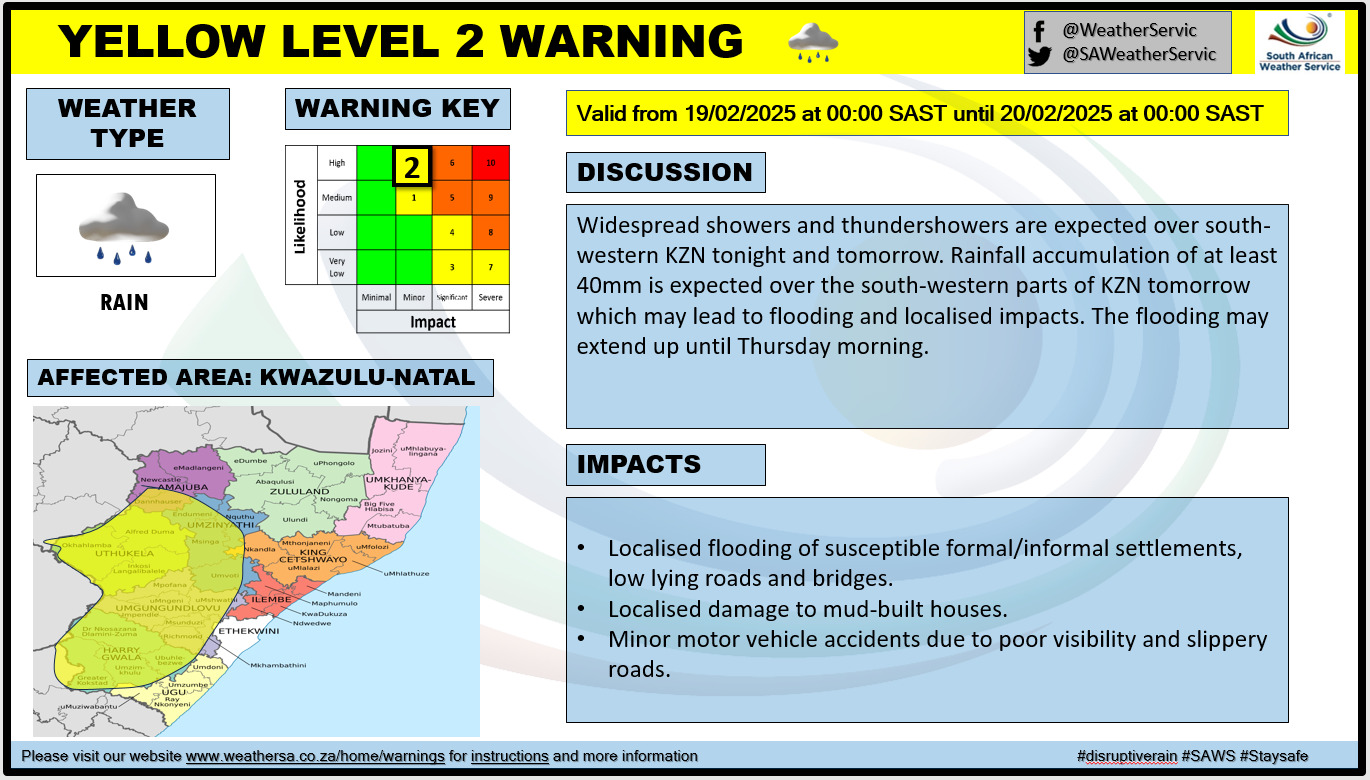
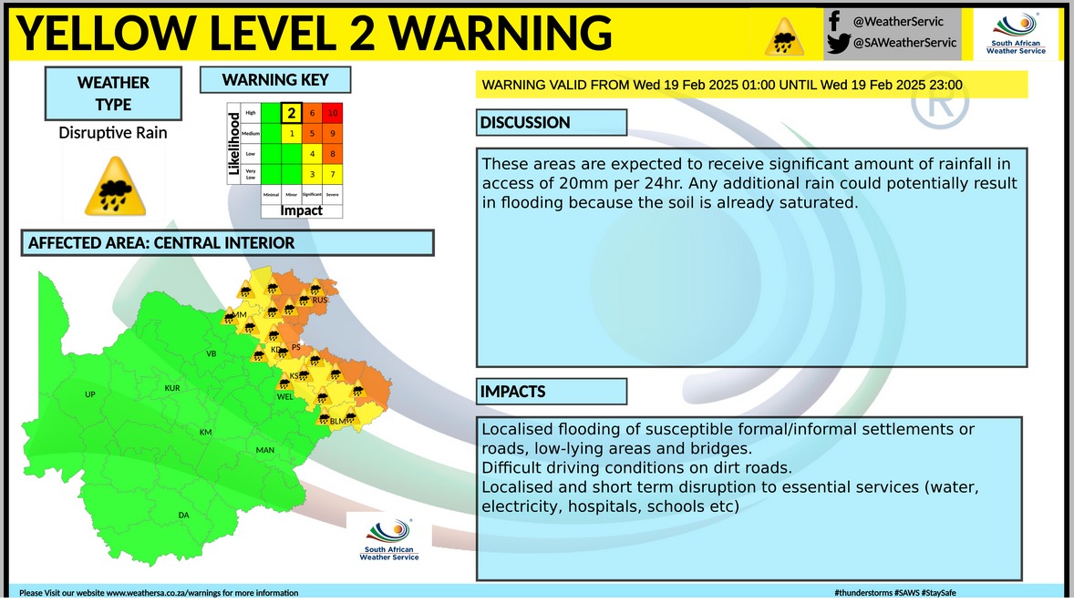
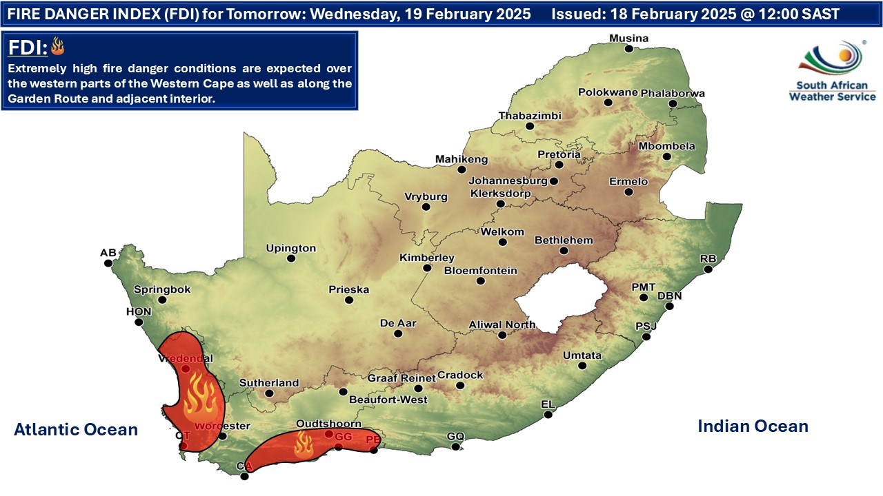
A newer forecast is available by clicking here. Continual showers are expected on Wednesday and might persist into Thursday morning, according to the SA Weather Service. There will be the likelihood of disruptive rain around the coastal region of the eastern half of the Eastern Cape as well as the southern coastline of KwaZulu-Natal. Widespread showers and thundershowers are expected over the north-western parts of KwaZulu-Natal on Wednesday and over most parts of KwaZulu-Natal on Thursday. Significant rainfall amounts of up to 100mm are expected in places over the northern parts as well as along the coast and adjacent interior of KwaZulu-Natal on Thursday which may lead to flooding as well as significant impacts. The flooding may extend up until Thursday morning in places. Warnings from the SA Weather Service for Wednesday: A. orange level 6 warning 🌧️ disruptive rain leading flooding of roads, bridges and settlements, damage to property and infrastructure and danger to life is expected over Gauteng, parts of North West and parts of Mpumalanga as per the map above. B. orange level 5 warning 🌧️ disruptive rain leading flooding of roads, bridges and settlements, damage to property and infrastructure and danger to life is expected over Gauteng, in the north and along the coast and adjacent interior of KwaZulu-Natal, extreme south-eastern parts of the Eastern Cape, eastern parts of Free Sate and North West as well as the south-western parts of Mpumalanga. C. yellow level 2 warning 🌧️ disruptive rain leading to localised flooding of susceptible bridges, roads and settlements, damage to property and infrastructure is expected over KwaZulu-Natal, central and eastern parts of the Free State and North West, western Bushveld of Limpopo, central and south-western parts of Mpumalanga as well as the extreme eastern prats of the Eastern Cape. D. yellow level 1 warning 💨 damaging winds resulting in difficulty in navigation, dragging anchor and small vessels taking on water is expected between Cape St Francis and Gansbaai. E. yellow level 2 warning ⛈️ severe thunderstorms leading to damaging wind, excessive lightning and hail mainly across the Northern Cape as per the map above. 🔥 Extremely high fire danger conditions are expected over the western parts of the Western Cape as well as along the Garden Route and adjacent interior on Wednesday. Regional forecasts from SAWS for Wednesday: 1. GAUTENG Morning fog in places, otherwise cloudy and cool with widespread showers. The UVB index: Moderate 2. MPUMALANGA Morning fog patches over the escarpment, otherwise cloudy and cool to warm with widespread showers and thundershowers but scattered in the north and north-east. 3. LIMPOPO Morning fog patches over the escarpment, otherwise cloudy and cool to warm with scattered showers and thundershowers but isolated in the extreme north-east and widespread in the south-western Bushveld. 4. NORTH WEST Cloudy and cool with widespread to scattered showers and thundershowers, but isolated in the extreme west. 5. FREE STATE Cloudy and cool to warm with scattered to widespread showers and thundershowers, but isolated in the south-west. 6. NORTHERN CAPE Morning fog patches along the north coast at first, otherwise partly cloudy and warm to hot and windy, but cool along the coast, with isolated showers and thundershowers over the interior, but scattered in the south. The wind along the coast will be fresh to strong southerly to south-easterly. 7. WESTERN CAPE Cloudy along the south coast where it will be windy, otherwise partly cloudy and warm to hot, but very hot in the west with isolated thundershowers in the north and north-western parts. The wind along the coast will be moderate to fresh south-westerly along the south coast, otherwise southerly to south-easterly. 8. WESTERN HALF OF THE EASTERN CAPE Cloudy and cool with isolated showers and thundershowers over the interior. The wind along the coast will be fresh to strong easterly. 9. EASTERN HALF OF THE EASTERN CAPE Cloudy and cold, but cool along the coast with scattered showers and thundershowers but widespread in the east. The wind along the coast will be moderate to fresh south-easterly, becoming easterly by evening. 10. KWAZULU-NATAL Cloudy and cool but cold in the south-west with widespread showers and thundershowers. The wind along the coast will be moderate to fresh southerly to south-easterly. Travellers forecasts from SAWS for Wednesday: PRETORIA Cloudy with widespread showers. Minimum/Maximum: 18/21°C JOHANNESBURG Cloudy with widespread showers. Minimum/Maximum: 15/19°C VEREENIGING Cloudy with widespread showers. Minimum/Maximum: 16/20°C MBOMBELA Cloudy with scattered showers and thundershowers. Minimum/Maximum: 19/24°C POLOKWANE Cloudy with scattered showers and thundershowers. Minimum/Maximum: 18/23°C MAHIKENG Cloudy, with scattered showers and thundershowers. Minimum/Maximum: 16/21°C VRYBURG Cloudy with scattered showers and thundershowers. Minimum/Maximum: 18/24°C BLOEMFONTEIN Cloudy with scattered showers and thundershowers. Minimum/Maximum: 17/21°C KIMBERLEY Cloudy and windy with isolated showers and thundershowers. Minimum/Maximum: 18/26°C UPINGTON Partly cloudy with isolated showers and thundershowers. Minimum/Maximum: 20/34°C CAPE TOWN Cloudy at first, otherwise partly cloudy, becoming fine late afternoon. Wind: Light to moderate south-easterly. Minimum/Maximum: 21/34°C GEORGE Cloudy, becoming partly cloudy late afternoon. Wind: Moderate to fresh south-easterly but strong at times. Minimum/Maximum: 19/24°C GQEBERHA Cloudy. Wind: Moderate to fresh south-westerly. Minimum/Maximum: 19/23°C EAST LONDON Cloudy with light rain. Wind: Moderate easterly, becoming fresh north-easterly in the afternoon. Minimum/Maximum: 19/22°C DURBAN Cloudy with widespread showers and thundershowers. Wind: Moderate to fresh southerly to south-easterly. Minimum/Maximum: 21/24°C RICHARDS BAY Cloudy with widespread showers and thundershowers. Wind: Moderate to fresh southerly to south-easterly. Minimum/Maximum: 21/26°C PIETERMARITZBURG Cloudy with widespread showers and thundershowers. Minimum/Maximum: 16/21°C This forecast is usually updated a few times per day.
Please be sure to send photos and videos to us via whatsapp and also tell us where and when they were taken. Follow our channels
Maps for Thursday 20 February
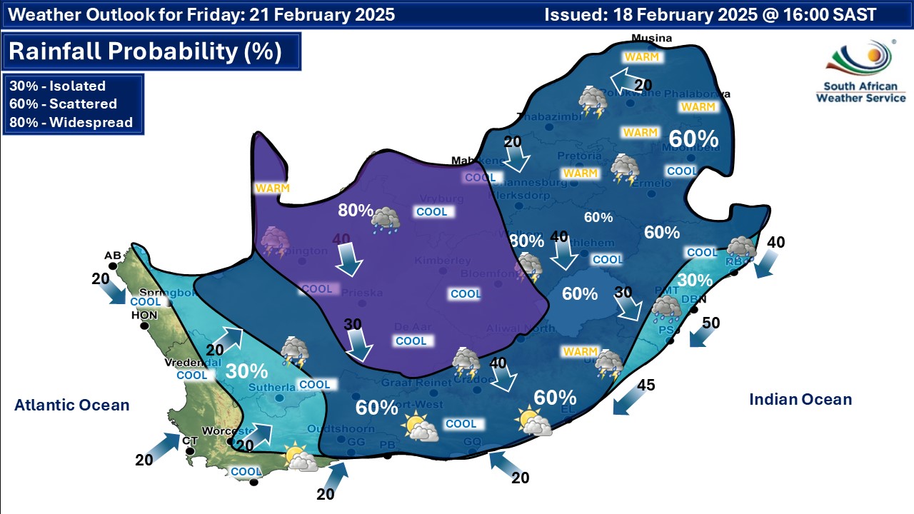
 Maps for Friday 21 February
|