
   Maps partly based on data from the SA Weather Service
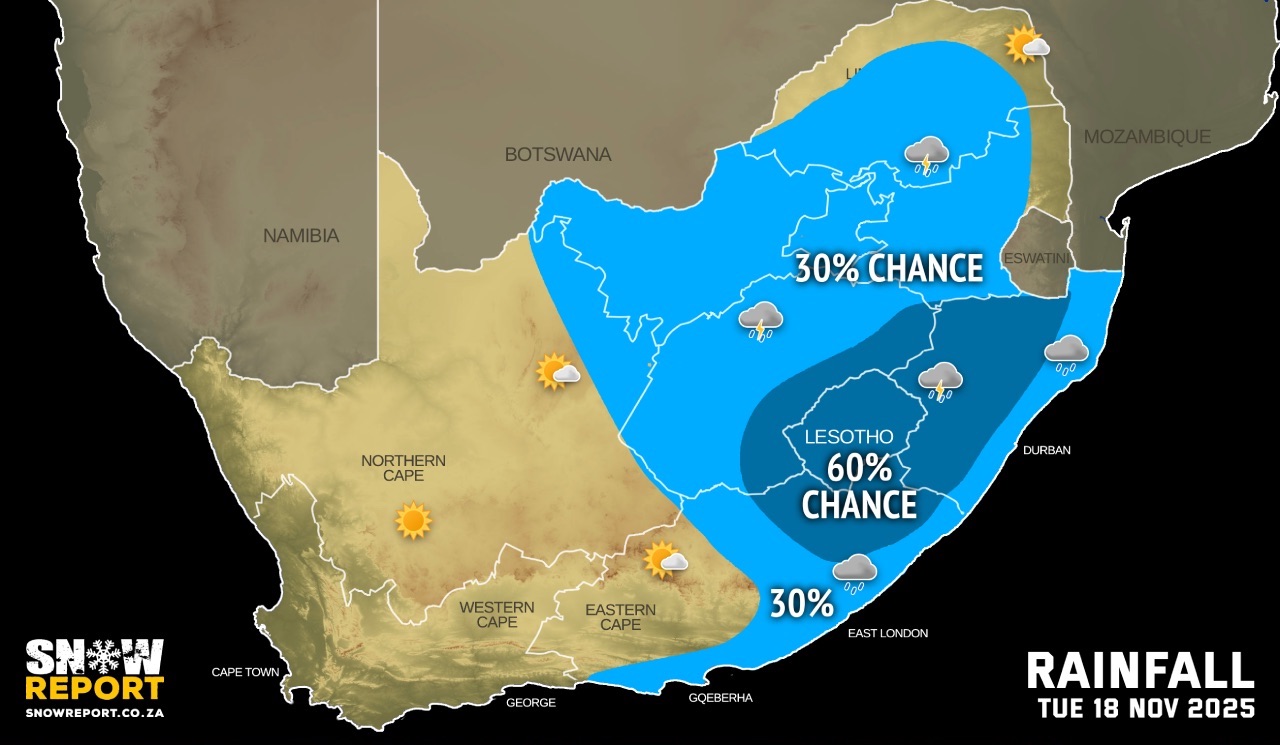
TUESDAY WEATHER: Fog, thunderstorms in the east and snow possible for the DrakensbergBy Staff WriterPublished: 17 November 2025 [updated 18 November] This forecast is for: Tue 18 November 2025 The maps cover: Tue 18 Nov – Wed 19 Nov
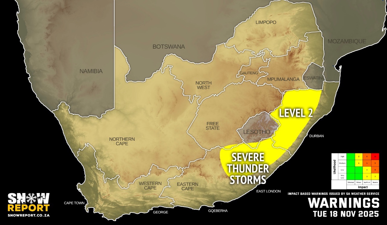
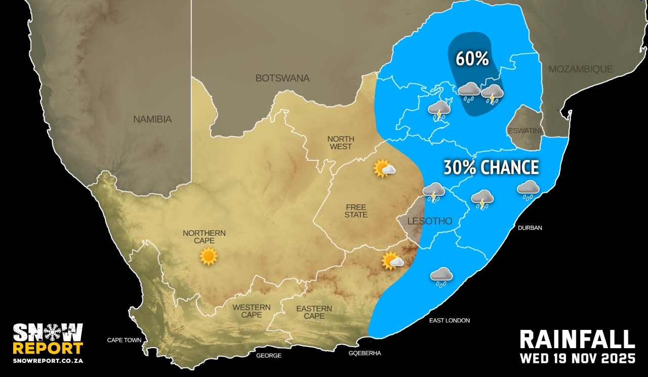
The latest forecast is available by clicking here. Snow is possible at high elevations in the Drakensberg from Tuesday afternoon. [UPDATE] Snow is falling in Lesotho on Tuesday evening – we have posted photos and video on our social media. Warnings from the SA Weather Service for Tuesday: A. level 2 warning severe thunderstorms leading to localised damage to infrastructure, settlements (informal), property, vehicles, livelihood and localised short-term disruption to municipal and other essential services over most of KwaZulu-Natal and the eastern interior of the Eastern Cape, as per the map above. Extremely high fire danger conditions are expected in places over the central parts of the Northern Cape and the western parts of the Western Cape. Warnings from the SA Weather Service for Wednesday: A. level 2 warning severe thunderstorms over the Highveld of Mpumalanga as well as the central and southern parts of Limpopo in the afternoon due to heavy downpours, hail and strong damaging winds. Regional forecasts from the SA Weather Service for Tuesday: GAUTENG Cloudy and cool with isolated showers and thundershowers. MPUMALANGA Morning fog patches in places along the escarpment, otherwise partly cloudy and cool to warm with isolated showers and rain over the Highveld and escarpment areas. LIMPOPO Cloudy in the morning with drizzle and fog in places in the west and south, otherwise partly cloudy and warm with isolated showers and rain in the central and southern parts. NORTH-WEST Cloudy in the morning, otherwise partly cloudy and cool to warm with isolated showers and thundershowers. THE FREE STATE Partly cloudy, windy and cool to warm, with isolated showers and thundershowers but scattered along the Lesotho border. THE NORTHERN CAPE Fine in the west, otherwise partly cloudy, windy and warm to hot with isolated showers and thundershowers over the central and the eastern parts. The wind along the coast will be moderate to fresh south-easterly to southerly THE WESTERN CAPE Partly cloudy in places along the south coast, otherwise fine, windy and warm to hot but very hot in places in the West Coast district. The wind along the coast will be fresh to strong easterly to south-easterly, but moderate along the south coast. THE WESTERN HALF OF THE EASTERN CAPE Morning fog patches in the south, otherwise partly cloudy and warm but cool along the coast where it will become cloudy with isolated showers and rain. The wind along the coast will be Light north-easterly at first, otherwise light to moderate south-easterly. THE EASTERN HALF OF THE EASTERN CAPE Morning fog patches in places over the interior, otherwise partly cloudy and cool to warm with isolated showers and thundershowers but scattered in the north-east. The wind along the coast will be moderate to fresh north-easterly. KWAZULU-NATAL Morning fog patches in places over the interior, otherwise partly cloudy and cool to warm with isolated showers and thundershowers but scattered in the west. The wind along the coast will be light south-easterly in the extreme north at first, otherwise moderate northerly to north-easterly. Travellers forecasts from the SA Weather Service for Tuesday: PRETORIA Cloudy with isolated showers and thundershowers. Minimum/Maximum: 11/22°C JOHANNESBURG Cloudy with isolated showers and thundershowers. Minimum/Maximum: 10/20°C VEREENIGING Cloudy with isolated showers and thundershowers. Minimum/Maximum: 11/20°C MBOMBELA Morning patches, otherwise partly cloudy with isolated afternoon showers and rain. Minimum/Maximum: 13/24°C POLOKWANE Cloudy in the morning, becoming partly cloudy with isolated afternoon showers and rain. Minimum/Maximum: 12/22°C MAHIKENG Partly cloudy with isolated showers and thundershowers. Minimum/Maximum: 13/24°C VRYBURG Partly cloudy with isolated showers and thundershowers. Minimum/Maximum: 14/27°C BLOEMFONTEIN Partly cloudy windy with isolated showers and thundershowers. Minimum/Maximum: 13/26°C KIMBERLEY Partly cloudy windy with isolated showers and thundershowers. Minimum/Maximum: 15/31°C UPINGTON Partly cloudy and windy. Minimum/Maximum: 20/33°C CAPE TOWN Fine. Wind: Moderate to fresh south-easterly. Minimum/Maximum: 18/28°C GEORGE Partly cloudy. Wind: Light to moderate easterly to south-easterly. Minimum/Maximum: 11/23°C GQEBERHA Partly cloudy becoming cloudy with isolated showers and rain in the evening. Wind: Light north-easterly at first, otherwise light to moderate south-easterly. Minimum/Maximum: 15/23°C EAST LONDON Partly cloudy. Wind: Moderate to fresh north-easterly. Minimum/Maximum: 16/24°C DURBAN Cloudy with isolated showers and thundershowers. Wind: Moderate to fresh easterly to north-easterly. Minimum/Maximum: 17/24°C RICHARDS BAY Cloudy with isolated showers and thundershowers. Wind: Light north-westerly at first, otherwise light to moderate easterly to north-easterly. Minimum/Maximum: 14/26°C PIETERMARITZBURG Morning fog patches, otherwise partly cloudy with scattered showers and thundershowers. Minimum/Maximum: 10/25°C This forecast is usually updated a few times per day.
Please be sure to send photos and videos to us via whatsapp and also tell us where and when they were taken. Follow our channels
|