
   Maps partly based on data from the SA Weather Service
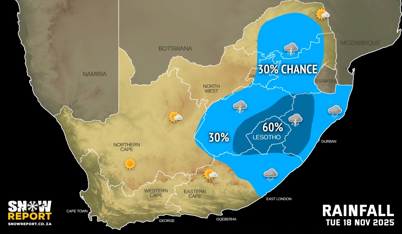
MONDAY WEATHER: A chilly start in places – rain and thunderstorms continue in the eastBy Staff WriterPublished: 16 November 2025 [updated 17 November] This forecast is for: Mon 17 November 2025 The maps cover: Mon 17 Nov – Tue 18 Nov
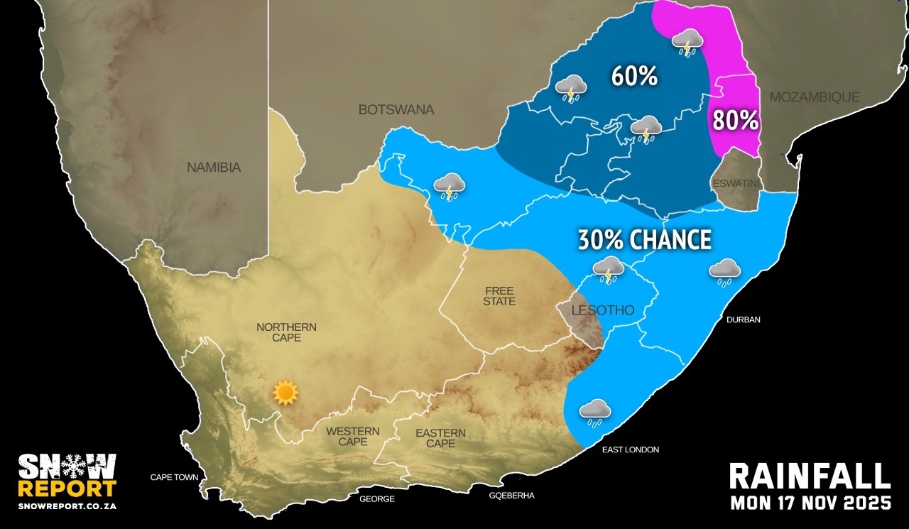
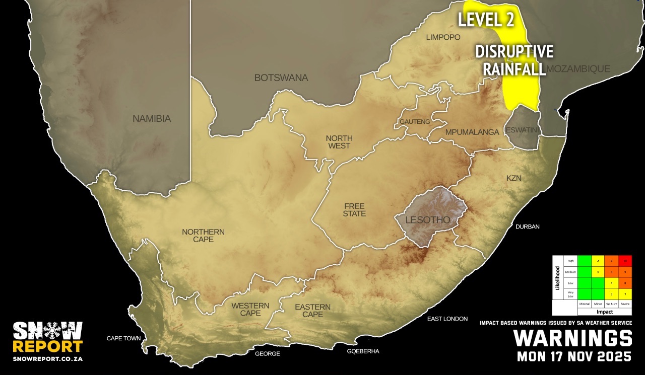
The latest forecast is available by clicking here. The impacts from the cut-off low (COL) wind down on Monday. It will be chilly overnight and morning fog can be expected in some regions. Warnings from the SA Weather Service for Monday: A. level 2 warning disruptive rainfall leading to localised flooding of susceptible formal/informal settlements or roads, low-lying areas and bridges are expected the Limpopo Valley as well as the Lowveld of Limpopo and Mpumalanga. Extremely high fire danger conditions are expected over the Kamiesberg municipality of the Northern Cape and the Matzikama and Bergrivier municipalities of the Western Cape. Regional forecasts from the SA Weather Service for Monday: GAUTENG Cloudy and cold with scattered showers and thundershowers. It will be cool in the extreme north. MPUMALANGA Cloudy and cool to cold with scattered showers and thundershowers, but widespread in the Lowveld. LIMPOPO Cloudy and cool to cold with scattered showers and thundershowers, but widespread in the Lowveld and Limpopo Valley. NORTH-WEST Cloudy and cold to cool with isolated showers and thundershowers, but scattered in the east. It will become partly cloudy in the west from the afternoon. THE FREE STATE Cloudy in the east with isolated showers and thundershowers, otherwise partly cloudy and cold to cool. THE NORTHERN CAPE Partly cloudy over the central and eastern parts, otherwise fine and warm to hot. The wind along the coast will be fresh to strong south-easterly THE WESTERN CAPE Partly cloudy in the extreme north-east, otherwise fine, windy and warm to hot but very hot in places in the west. The wind along the coast will be moderate to fresh easterly to south-easterly becoming strong in the afternoon. THE WESTERN HALF OF THE EASTERN CAPE Morning fog in places over the interior, otherwise fine and warm to hot. It will be partly cloudy in the north. The wind along the coast will be light to moderate north-easterly at first, otherwise fresh to strong easterly. THE EASTERN HALF OF THE EASTERN CAPE Cloudy and cool with fog in places in the morning, becoming partly cloudy in the north and west in the afternoon. Isolated light showers and rain can be expected in places in the south and east at times. The wind along the coast will be Light to moderate north-easterly, freshening from the south in the afternoon. KWAZULU-NATAL Morning fog in places over the western interior, otherwise cloudy and cold to cool with isolated showers and thundershowers. The wind along the coast will be light to moderate south-easterly becoming light to moderate easterly to north-easterly south of Richards Bay in the afternoon. Travellers forecasts from the SA Weather Service for Monday: PRETORIA Cloudy with scattered showers and thundershowers. Minimum/Maximum: 13/17°C JOHANNESBURG Cloudy with scattered showers and thundershowers. Minimum/Maximum: 12/18°C VEREENIGING Cloudy with scattered showers and thundershowers. Minimum/Maximum: 11/16°C MBOMBELA Cloudy with scattered showers and thundershowers. Minimum/Maximum: 13/16°C POLOKWANE Cloudy with scattered showers and thundershowers. Minimum/Maximum: 14/17°C MAHIKENG Cloudy with scattered showers and thundershowers. Minimum/Maximum: 13/18°C VRYBURG Cloudy with isolated showers and thundershowers. It will become partly cloudy from the afternoon. Minimum/Maximum: 13/24°C BLOEMFONTEIN Partly cloudy. Minimum/Maximum: 11/23°C SUTHERLAND Clear skies. Minimum/Maximum: 6/28°C KIMBERLEY Partly cloudy. Minimum/Maximum: 13/26°C UPINGTON Partly cloudy. Minimum/Maximum: 18/31°C CAPE TOWN Fine. Wind: Moderate to fresh south-easterly becoming strong from the afternoon. Minimum/Maximum: 16/33°C GEORGE Fine. Wind: Light north-easterly in the morning, otherwise moderate to fresh easterly to south-easterly. Minimum/Maximum: 11/23°C GQEBERHA Cloudy in the early morning, otherwise fine. Wind: Light north-easterly at first, otherwise moderate to fresh easterly. Minimum/Maximum: 14/22°C EAST LONDON Partly cloudy, but cloudy at times. Wind: Light north-easterly at first, otherwise moderate to fresh easterly. Minimum/Maximum: 14/22°C DURBAN Cloudy with isolated showers and rain. Wind: Light to moderate southerly to south-westerly becoming easterly to north-easterly in the afternoon. Minimum/Maximum: 16/20°C RICHARDS BAY Cloudy with isolated showers and rain. It will become partly cloudy in the afternoon. Wind: Light to moderate southerly to south-easterly. Minimum/Maximum: 16/21°C PIETERMARITZBURG Evening fog, otherwise cloudy with isolated showers and rain. Minimum/Maximum: 11/18°C This forecast is usually updated a few times per day.
Please be sure to send photos and videos to us via whatsapp and also tell us where and when they were taken. Follow our channels
|