
 More maps below the forecast
A hot Sunday and a warning for severe thunderstorms in the east16 November 2024 [updated 17 November]By Staff Writer
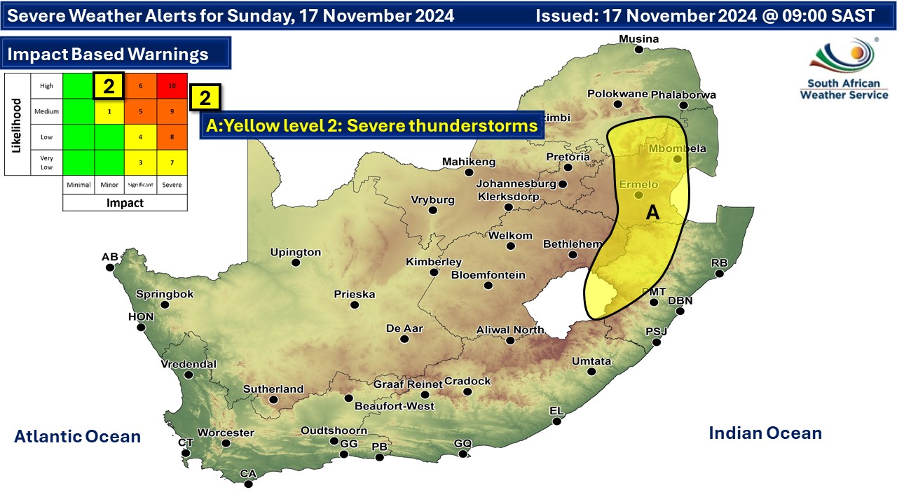
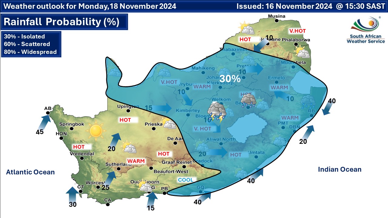
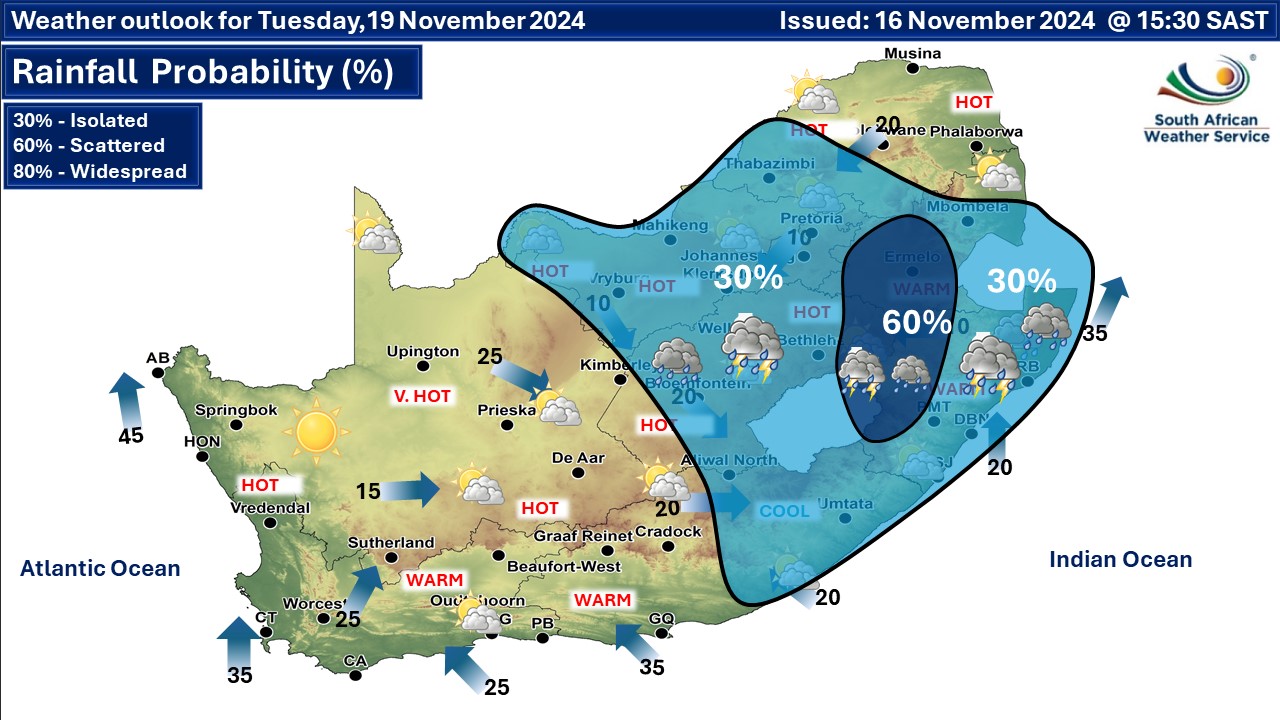
Isolated showers and thundershowers can be expected over the central and eastern parts of the country, but scattered over Mpumalanga and vast parts of Gauteng. A heat wave with persistently high temperatures is expected over Matatiele and Umzimvubu Local Municipalities of Eastern Cape. Warnings from the SA Weather Service (SAWS) for Sunday: A. yellow level 2 warning for severe thunderstorms over parts of Mpumalanga and KwaZulu-Natal, as per the map below. This warning was upgraded from a level 1 on Sunday. Extremely high fire danger conditions are expected in place, except in the extreme north-east, over the southern parts of Free State as well as over the Limpopo Valley. Regional forecasts from SAWS for Sunday: 1. GAUTENG Partly cloudy and warm to hot with scattered showers and thundershowers, but isolated in the south-west. The expected UVB sunburn index: High 2. MPUMALANGA Partly cloudy warm with isolated showers and thundershowers. It will be hot in the Lowveld. 3. LIMPOPO Partly cloudy and warm to hot in the afternoon with isolated showers and thundershowers except in the extreme north. 4. NORTH WEST Partly cloudy and hot to very hot with isolated afternoon showers and thundershowers. 5. FREE STATE Partly cloudy and warm to hot, with isolated afternoon showers and thundershowers in the northern and eastern part. 6. NORTHERN CAPE Morning fog along the coast where it will be cool, otherwise fine and hot to very hot but partly cloudy in the east with isolated afternoon showers and thundershowers in the extreme north-east. It will be extremely hot in places in the north. The wind along the coast will be moderate to fresh southerly to south-westerly. 7. WESTERN CAPE Fine and warm to hot but very hot over the eastern interior. The wind along the coast will be light easterly along the south coast in the morning, otherwise moderate to fresh south-westerly. The expected UVB sunburn index: Extreme 8. WESTERN HALF OF THE EASTERN CAPE Morning fog over the interior, otherwise fine and warm, but hot in the north-east. The wind along the coast will be fresh to strong easterly. 9. EASTERN HALF OF THE EASTERN CAPE Morning fog south of the escarpment, otherwise partly cloudy and warm with isolated thunderstorms over the extreme east. The wind along the coast will be light to moderate, easterly to north-easterly. 10. KWAZULU-NATAL Morning fog in places over the interior, otherwise partly cloudy and warm but hot in places in the north-west with isolated afternoon showers and thundershowers except in the extreme north-east. The wind along the coast will be moderate to fresh northerly in the extreme north in the morning, otherwise moderate south-westerly, becoming light to moderate north-easterly from the evening. The expected UVB sunburn index: High Travellers forecasts from SAWS for Sunday: PRETORIA Partly cloudy with scattered afternoon thundershowers. Minimum/Maximum: 15/31°C The expected UVB Sunburn Index: High JOHANNESBURG Partly cloudy with scattered afternoon thundershowers. Minimum/Maximum: 14/29°C VEREENIGING Partly cloudy with isolated afternoon thundershowers. Minimum/Maximum: 14/30°C MBOMBELA Partly cloudy with scattered afternoon thundershowers. Minimum/Maximum: 17/29°C POLOKWANE Partly cloudy with isolated afternoon thundershowers. Minimum/Maximum: 15/27°C MAHIKENG Partly cloudy with isolated afternoon thundershowers. Minimum/Maximum: 19/33°C VRYBURG Partly cloudy, with isolated afternoon thundershowers. Minimum/Maximum: 18/35°C BLOEMFONTEIN Fine, becoming partly cloudy from the afternoon. Minimum/Maximum: 17/34°C KIMBERLEY Fine, becoming partly cloudy from the afternoon. Minimum/Maximum: 17/37°C UPINGTON Fine. Minimum/Maximum: 19/39°C CAPE TOWN Fine becoming partly cloudy. Wind: light to moderate southerly. Minimum/Maximum: 16/28°C The expected UVB Sunburn Index: Extreme GEORGE Partly cloudy becoming fine. Wind: Light to moderate easterly. Minimum/Maximum: 13/22°C GQEBERHA Fine. Wind: Moderate to fresh easterly. Minimum/Maximum: 14/24°C EAST LONDON Partly cloudy. Wind: Light to moderate easterly to north-easterly. Minimum/Maximum: 15/23°C DURBAN Partly cloudy with a chance of light rain. Wind: Moderate southerly to south-westerly. Minimum/Maximum: 21/25°C The expected UVB Sunburn Index: High RICHARDS BAY Partly cloudy with a chance of light rain. Wind: Moderate southerly to south-westerly. Minimum/Maximum: 21/28°C PIETERMARITZBURG Morning fog patches, otherwise partly cloudy with isolated afternoon thundershowers. Minimum/Maximum: 17/26°C This forecast may change and updates issued more than once a day. Please be sure to send photos and videos to us via whatsapp and also tell us where and when they were taken. See below for a link to our whatsapp channel but since the link does not work in the instagram app you will need to send us a whatsapp message and we'll send you a link. Follow our channels
Standard users are welcome to use the standard sharing buttons on this page to share our content. It is NOT acceptable to download or screen grab for reposting. Other media and channels need to send us a request in order to embed or use of our forecasts, maps, as well as images and video from our users that we post (before doing so).
Issued on Sunday
 Issued on Saturday
  |