
 Rainfall probability. More maps below the forecast
A mostly hot weekend ahead but another cold front on the horizon16 January 2025 [updated 17 January]By Staff Writer
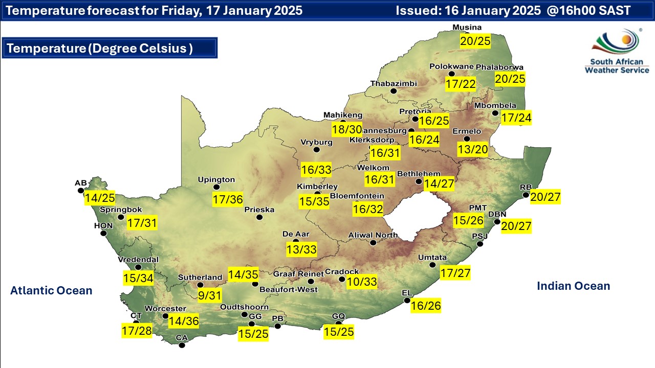
A newer forecast is available by clicking here but any warnings for Friday may still apply. Isolated showers and thundershowers in the central, and eastern parts but scattered in the extreme northern parts of Limpopo on Friday, according to the SA Weather Service (SAWS). Mostly cool to warm temperatures are expected but hot to very hot in places in the central parts of the county. Warnings from the SA Weather Service for Friday: Extremely high fire danger conditions are expected over the north-western parts of the Western Cape, the central and eastern parts of the Northern Cape and the south-western parts of the Free State. Regional forecasts from SAWS for Friday: 1. GAUTENG Cloudy in the morning, otherwise partly cloudy and cool with isolated thundershowers from the afternoon. It will be warm in the north. The expected UVB sunburn index: Moderate 2. MPUMALANGA Morning fog patches with a chance of drizzle along the escarpment, otherwise cloudy and cool to warm with isolated showers and thundershowers. 3. LIMPOPO Cloudy and cool to warm with isolated showers and thundershowers. Morning fog patches with a chance of drizzle is expected along the escarpment. 4. NORTH WEST Cloudy in places at first, otherwise partly cloudy and warm to hot with scattered showers and thundershowers but isolated in the east. 5. FREE STATE Cloudy in places at first with morning fog patches in the east, otherwise partly cloudy and warm to hot with isolated showers and thundershowers. 6. NORTHERN CAPE Cool along the coast, otherwise fine and warm to hot, but partly cloudy with isolated showers and thundershowers in the north-east. The wind along the coast will be moderate south-easterly becoming south-westerly in the afternoon. 7. WESTERN CAPE Partly cloudy in the north-east in the morning, otherwise fine and warm to hot but very hot over the Central and Little Karoo. The wind along the coast will be moderate to fresh easterly to south-easterly becoming moderate south-westerly along the west coast in the afternoon. The expected UVB sunburn index: Extreme 8. WESTERN HALF OF THE EASTERN CAPE Morning fog in patches over the interior, otherwise fine and warm, but hot in the extreme north. The wind along the coast will be moderate to fresh north-easterly. 9. EASTERN HALF OF THE EASTERN CAPE Cloudy in the east at first, otherwise partly cloudy and warm with isolated thundershowers in the east. It will become cloudy with a chance of light evening rain along the wild coast. The wind along the coast will be moderate to fresh north-easterly. 10. KWAZULU-NATAL Morning fog patches over the interior, otherwise cloudy and cool to warm with isolated showers and thundershowers. The wind along the coast will be light to moderate easterly to south-easterly north of Cape St. Lucia, reaching fresh at times, otherwise moderate to fresh north-easterly. The expected UVB sunburn index: High Travellers forecasts from SAWS for Friday: PRETORIA Cloudy in the morning, otherwise partly cloudy with isolated thundershowers from the afternoon. Minimum/Maximum: 16/25°C The expected UVB Sunburn Index: Moderate JOHANNESBURG Cloudy in the morning, otherwise partly cloudy with isolated thundershowers from the afternoon. Minimum/Maximum: 16/24°C VEREENIGING Cloudy in the morning, otherwise partly cloudy with isolated thundershowers from the afternoon. Minimum/Maximum: 15/24°C MBOMBELA Cloudy with morning fog patches and a chance of drizzle. Minimum/Maximum: 17/24°C POLOKWANE Cloudy with isolated showers and thundershowers. Minimum/Maximum: 17/22°C MAHIKENG Cloudy at first, otherwise partly cloudy with isolated showers and thundershowers. Minimum/Maximum: 18/30°C VRYBURG Partly cloudy with scattered showers and thundershowers. Minimum/Maximum: 16/33°C BLOEMFONTEIN Cloudy at first, otherwise partly cloudy with isolated showers and thundershowers. Minimum/Maximum: 16/32°C KIMBERLEY Partly cloudy with isolated showers and thundershowers. Minimum/Maximum: 15/35°C UPINGTON Partly cloudy. Minimum/Maximum: 17/36°C CAPE TOWN Fine. Wind: Moderate to fresh south-easterly. Minimum/Maximum: 17/28°C The expected UVB Sunburn Index: Extreme GEORGE Fine. Wind: Light and variable in the morning, otherwise moderate south-easterly. Minimum/Maximum: 15/25°C GQEBERHA Fine. Wind: Moderate to fresh north-easterly. Minimum/Maximum: 11/25°C EAST LONDON Partly cloudy. Wind: Moderate to fresh north-easterly. Minimum/Maximum: 16/26°C DURBAN Cloudy with isolated showers. Wind: Light and variable until mid-morning, otherwise moderate to fresh north-easterly. Minimum/Maximum: 20/27°C The expected UVB Sunburn Index: High RICHARDS BAY Cloudy with isolated showers. Wind: Light and variable until late morning, otherwise moderate to fresh easterly to north-easterly. Minimum/Maximum: 20/27°C PIETERMARITZBURG Morning fog patches, otherwise cloudy with isolated showers. Minimum/Maximum: 15/26°C This forecast is usually updated a few times per day.
Please be sure to send photos and videos to us via whatsapp and also tell us where and when they were taken. Follow our channels
Issued on Thursday
|