
   Swipe left or right for more maps, and see below for others
Orange level 5 warning for disruptive rainfall and possible flooding from MondayBy Staff WriterPublished: 16 February 2025 [updated 17 February] This forecast is for: Mon 17 February 2025 The maps cover: Mon 17 Feb – Wed 19 Feb
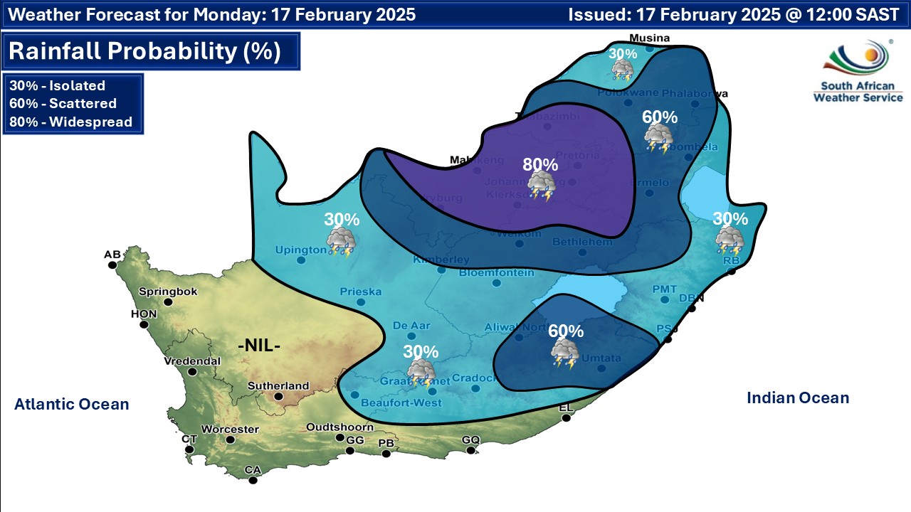
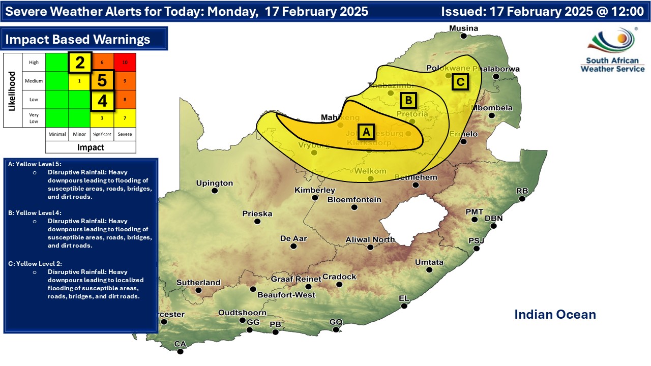
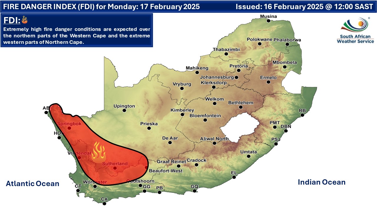
A newer forecast is available by clicking here. Isolated to scattered showers and thundershowers over the central and eastern parts of South Africa, but widespread in the extreme north-eastern and central parts of the country on Monday, according to the SA Weather Service. A significant amount of rain is indicated over parts of the central and eastern regions of South Africa over the first few days of the week, with some areas on the radar to receive over 100mm as far as we can tell from the data. According to SA Weather, a tropical airmass is expected to cause disruptive rain during this week with amounts in the region of 30mm to 50mm daily until Tuesday. Continual showers are also expected on Wednesday and might persist into Thursday morning. There will still be the likelihood of disruptive rain around the coastal region of the eastern half of the Eastern Cape as well as the southern coastline of KwaZulu-Natal. Warnings from the SA Weather Service for Monday: A. orange level 5 warning 🌧️ disruptive rainfall resulting in flooding of informal settlements, low-lying areas and bridges as well as dirt roads is expected in places over the central parts of North West and the southern parts of Gauteng. B. yellow level 4 warning 🌧️ disruptive rainfall resulting in flooding of informal settlements, low-lying areas and bridges as well as dirt roads is expected in places over North Wes, except in the central parts, extreme northern parts of Free State, northern parts of Gauteng as well as the extreme western parts of Mpumalanga and the southern-western parts of Limpopo. C. yellow level 2 warning 🌧️ disruptive rainfall resulting in localized flooding of informal settlements, low-lying areas and bridges as well as dirt roads is expected in places over the western parts of Mpumalanga and southern parts of Limpopo. 🔥 Extremely high fire danger conditions are expected in places over northern parts of the Western Cape and the extreme western parts of Northern Cape. Regional forecasts from SAWS for Monday: 1. GAUTENG Cloudy and cool with widespread showers and thundershowers. 2. MPUMALANGA Morning fog patches along the escarpment, otherwise cloudy and cool with scattered showers and thundershowers, but isolated in the Lowveld where it will be warm. 3. LIMPOPO Morning fog along the escarpment, otherwise cloudy and cool to warm with widespread showers and thundershowers in the extreme south-west, otherwise scattered but isolated in the north-west. 4. NORTH WEST Cloudy and cool with widespread showers and thundershowers, but scattered in the extreme west. 5. FREE STATE Cloudy and cool to warm with scattered to widespread showers and thundershowers but isolated in the south where it will be partly cloudy. 6. NORTHERN CAPE Fine in the extreme west with morning and evening fog along the coast where it will be cool, otherwise partly cloudy and warm to hot with isolated showers and thundershowers in the east, but scattered in the north-east. It will be very hot in places in the north. The wind along the coast will be fresh to strong southerly to south-westerly. 7. WESTERN CAPE Fine and warm to hot, but partly cloudy over the extreme eastern parts with morning and evening fog patches over the south-eastern parts. Isolated showers and thundershowers can be expected over the extreme north-eastern parts. The wind along the coast will be light to moderate south-easterly along the south coast, otherwise fresh to strong southerly to south-easterly becoming south-westerly north of Robben Island by the afternoon. 8. WESTERN HALF OF THE EASTERN CAPE Cloudy in the south-east, otherwise partly cloudy and warm with isolated afternoon thunderstorms in the north. It will be hot over the interior. The wind along the coast will be light to moderate easterly to south-easterly. 9. EASTERN HALF OF THE EASTERN CAPE Partly cloudy and hot with isolated to scattered showers and thundershowers, except in the south-west. It will be cloudy and warm south of the escarpment. The wind along the coast will be moderate to fresh easterly to North-easterly. 10. KWAZULU-NATAL Morning fog in places over the interior, otherwise partly cloudy and warm with isolated showers and thundershowers but scattered in the north-west. It will be cool in the south-west. The wind along the coast will be moderate to fresh easterly to north-easterly. Travellers forecasts from SAWS for Monday: PRETORIA Cloudy with widespread showers and thundershowers. Minimum/Maximum: 16/20 °C JOHANNESBURG Cloudy with widespread showers and thundershowers. Minimum/Maximum: 15/18 °C VEREENIGING Cloudy with widespread showers and thundershowers. Minimum/Maximum: 16/19 °C MBOMBELA Fog in the morning, otherwise cloudy with scattered showers and thundershowers Minimum/Maximum: 19/24 °C POLOKWANE Cloudy with scattered showers and thundershowers. Minimum/Maximum: 18/21 °C MAHIKENG Cloudy with widespread showers and thundershowers. Minimum/Maximum: 17/20 °C VRYBURG Cloudy with widespread showers and thundershowers. Minimum/Maximum: 18/21 °C BLOEMFONTEIN Partly cloudy with isolated showers and thundershowers. Minimum/Maximum: 17/26 °C KIMBERLEY Partly cloudy with isolated showers and thundershowers. Minimum/Maximum: 20/29 °C UPINGTON Partly cloudy with isolated showers and thundershowers. Minimum/Maximum: 22/35 °C CAPE TOWN Fine. Wind: Fresh to strong south-easterly. Minimum/Maximum: 19/26 °C GEORGE Cloudy with fog in the morning and evening, otherwise partly cloudy. Wind: Moderate south to south-easterly. Minimum/Maximum: 17/24 °C GQEBERHA Fine. Wind: Light to moderate easterly to south-easterly. Minimum/Maximum: 19/26 °C EAST LONDON Partly cloudy. Wind: Moderate easterly to south-easterly Minimum/Maximum: 20/29 °C DURBAN Partly cloudy with isolated showers and thundershowers. Wind: Light to moderate easterly to north-easterly Minimum/Maximum: 24/29 °C RICHARDS BAY Partly cloudy with isolated showers and thundershowers. Wind: Moderate to fresh easterly to north-easterly. Minimum/Maximum: 24/31 °C PIETERMARITZBURG Morning fog patches, otherwise partly cloudy with isolated showers and thundershowers. Minimum/Maximum: 18/30°C This forecast is usually updated a few times per day.
Please be sure to send photos and videos to us via whatsapp and also tell us where and when they were taken. Follow our channels
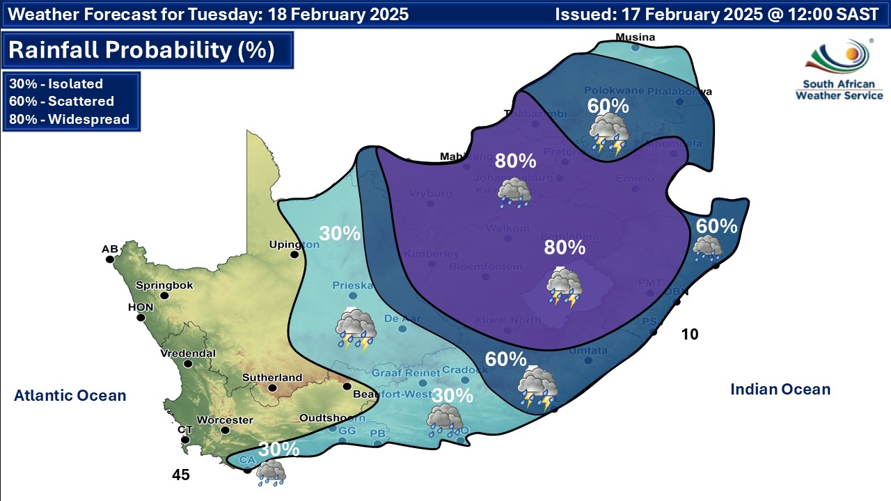
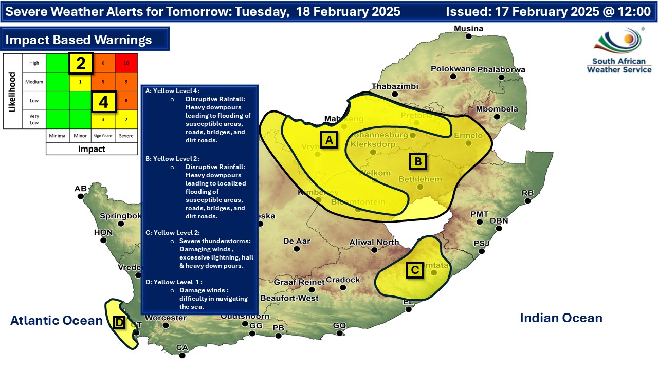
Maps for Tuesday 18 February
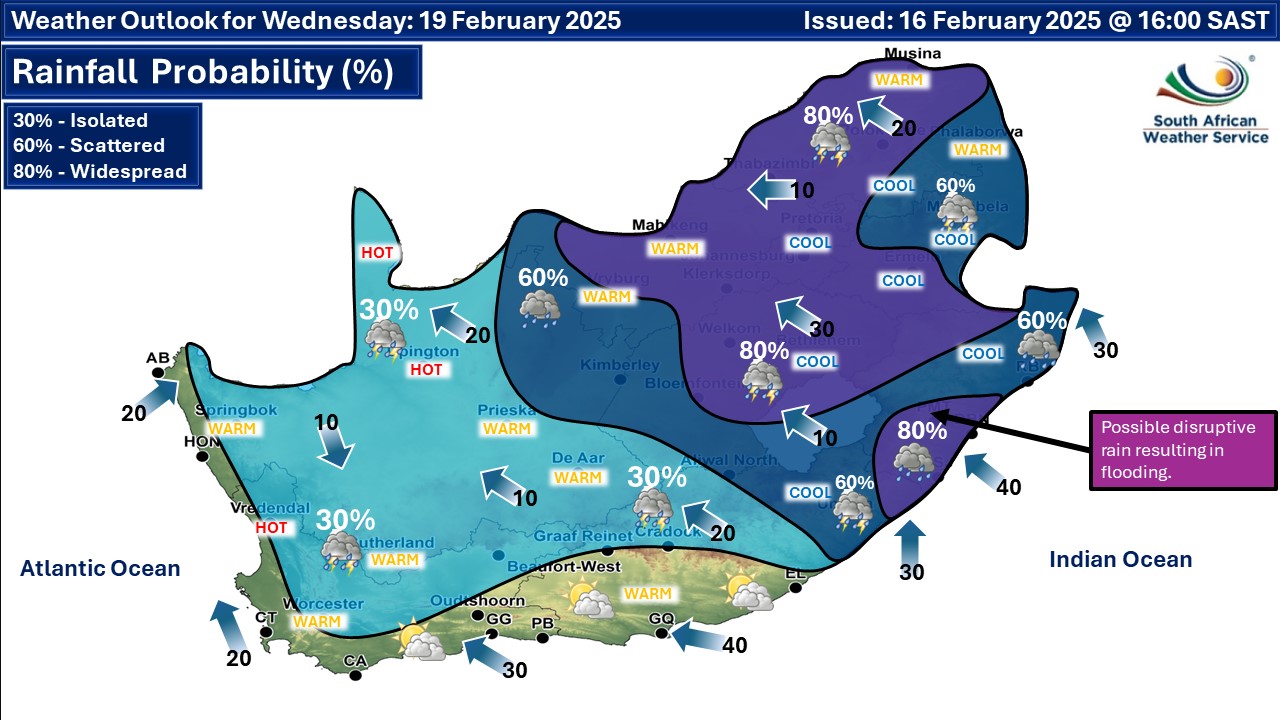
  Maps for Wednesday 19 February
|