
  Maps partly based on data from the SA Weather Service
WEDNESDAY WEATHER: Severe thunderstorm warnings for eight provinces including a level 5By Staff WriterPublished: 16 December 2025 [updated 17 December] This forecast is for: Wed 17 December 2025 The maps cover: Wed 17 Dec – Wed 17 Dec
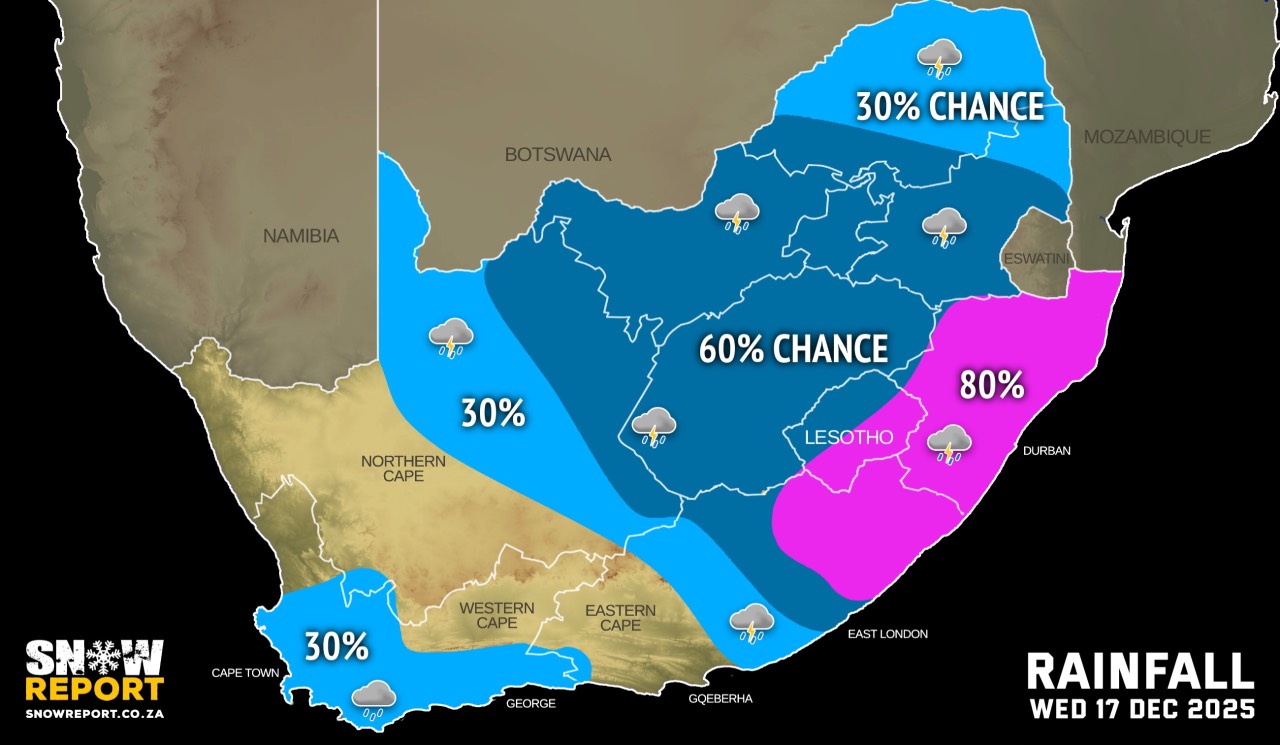
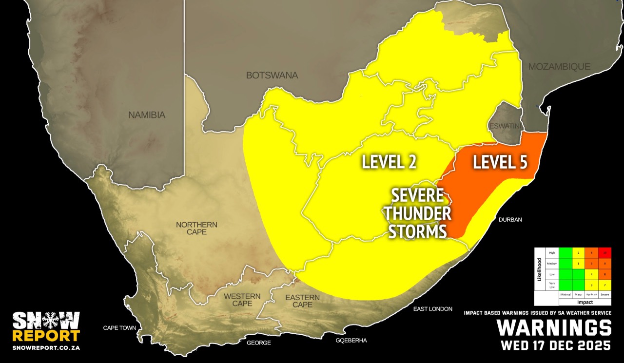
The latest forecast is available by clicking here. Models are indicating rain in excess of 50 mm for areas over the Midlands, western and northern parts of KwaZulu-Natal between Wednesday afternoon and Thursday morning, and significant impacts are possible over these areas. It will be cooler in many parts of the country on Wednesday. Warnings from the SA Weather Service for Wednesday: A. level 5 warning for severe thunderstorms leading to flooding of susceptible roads, settlements and low-lying bridges/areas, excessive lightning, strong damaging winds and large amounts of small hail and/or large hail over KwaZulu-Natal except in the south-east coast. B. level 2 warning for severe thunderstorms leading to localised flooding of susceptible roads, settlements and low-lying bridges/areas, excessive lightning, strong damaging winds and large amounts of small hail and/or large hail in places in Gauteng, North West, Free State, eastern part of the Northern Cape, northern part of the Eastern Cape, south-eastern coast of KwaZulu-Natal and all of Mpumalanga. Most of Limpopo is now also included in this warning. Extremely high fire danger conditions are expected over the Kareeberg Local Municipality of Northern Cape. Regional forecasts from the SA Weather Service for Wednesday: GAUTENG Fine at first, otherwise cloudy and warm, with scattered showers and thundershowers. MPUMALANGA Partly cloudy and warm to hot, becoming cloudy in the southern half. Scattered showers and thundershower are expected, isolated in the east. LIMPOPO Partly cloudy and warm to hot, becoming cloudy in the south-west. Isolated showers and thundershower are expected but scattered in the extreme south. NORTH-WEST Partly cloudy and warm, becoming cloudy with scattered showers and thundershowers. THE FREE STATE Partly cloudy and cool to warm, with scattered showers and thundershowers. It will become cloudy in most parts by the afternoon. THE NORTHERN CAPE Morning fog patches along the coast and adjacent interior where it will be cool, otherwise partly cloudy and warm to hot, but fine in the west with isolated showers and thundershowers but scattered in the extreme east. The wind along the coast will be light and variable in the morning, otherwise fresh to strong southerly to south-easterly. THE WESTERN CAPE Partly cloudy and cool to warm, with isolated rain and showers over the south-western parts in the early morning, spreading to the southern parts from mid-morning where it will be cloudy. It will become fine in the north-west from the afternoon. The wind along the coast will be moderate to fresh southerly to south-westerly. THE WESTERN HALF OF THE EASTERN CAPE Cloudy in the south with light showers east of Port Elizabeth, otherwise partly cloudy and warm with isolated showers and thundershowers in the north. It will be cool in places along the coast. The wind along the coast will be fresh to strong south-westerly. THE EASTERN HALF OF THE EASTERN CAPE Cloudy and warm with scattered showers and thundershowers, but widespread in north and east. The wind along the coast will be moderate to fresh south-westerly. KWAZULU-NATAL Partly cloudy and warm to hot, becoming cloudy in the afternoon with widespread showers and thundershowers. The wind along the coast will be moderate to fresh northerly to north-easterly, becoming south-westerly from the south in the afternoon, except in the north. Travellers forecasts from the SA Weather Service for Wednesday: PRETORIA Fine, becoming cloudy with scattered showers and thundershowers. Minimum/Maximum: 16/29°C JOHANNESBURG Fine at first, otherwise cloudy, with scattered showers and thundershowers. Minimum/Maximum: 15/26°C VEREENIGING Fine at first, otherwise cloudy, with scattered showers and thundershowers. Minimum/Maximum: 16/27°C MBOMBELA Partly cloudy with scattered showers and thundershowers. Minimum/Maximum: 17/31°C POLOKWANE Partly cloudy with isolated showers and thundershowers. Minimum/Maximum: 15/30°C MAHIKENG Partly cloudy, with scattered showers and thundershowers. Minimum/Maximum: 17/27°C VRYBURG Partly cloudy at first, otherwise cloudy with scattered showers and thundershowers. Minimum/Maximum: 18/27°C BLOEMFONTEIN Cloudy, with scattered showers and thundershowers. Minimum/Maximum: 17/25°C KIMBERLEY Partly cloudy, with scattered showers and thundershowers. Minimum/Maximum: 18/28°C UPINGTON Partly cloudy, with isolated showers and thundershowers. Minimum/Maximum: 21/32°C CAPE TOWN Partly cloudy with light rain in the morning, becoming fine from the afternoon. Wind: Light to moderate southerly to south-westerly. Minimum/Maximum: 18/23°C GEORGE Cloudy. Wind: Moderate south-westerly, becoming light and variable from the evening. Minimum/Maximum: 16/22°C GQEBERHA Cloudy. Wind: Fresh to strong south-westerly. Minimum/Maximum: 16/21°C EAST LONDON Partly cloudy, becoming cloudy with scattered showers and rain. Wind: Fresh to strong south-westerly. Minimum/Maximum: 18/23°C DURBAN Partly cloudy, becoming cloudy in the afternoon with widespread showers and thundershowers. Wind: Light to moderate northerly to north-easterly becoming south-westerly in the afternoon. Minimum/Maximum: 24/30°C RICHARDS BAY Partly cloudy, becoming cloudy in the afternoon with widespread showers and thundershowers. Wind: Moderate to fresh northerly to north-easterly. Minimum/Maximum: 21/35°C PIETERMARITZBURG Partly cloudy, becoming cloudy in the afternoon with widespread showers and thundershowers. Minimum/Maximum: 20/31°C This forecast is usually updated a few times per day.
Please be sure to send photos and videos to us via whatsapp and also tell us where and when they were taken. Follow our channels
|