
     Swipe left or right for more maps, and see below for others
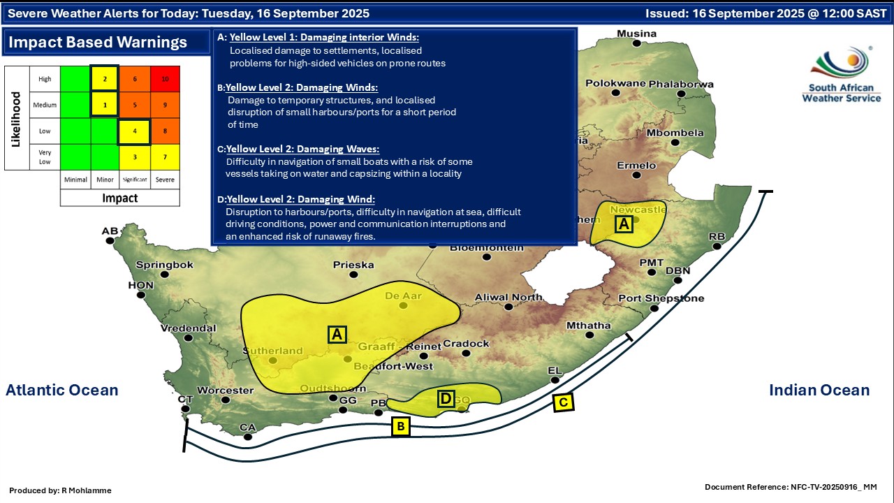
Four wind and damaging wave warnings for Tuesday including a level 4By Staff WriterPublished: 15 September 2025 [updated 16 September] This forecast is for: Tue 16 September 2025 The maps cover: Tue 16 Sep – Thu 18 Sep
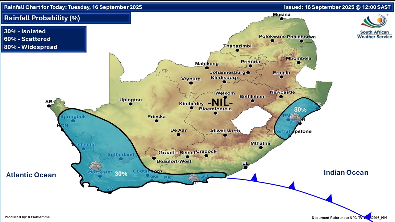
A newer forecast is available by clicking here. A cold front is expected to pass south of the country on Monday, with a high-pressure system ridging behind it, as a result strong to gale force (50 to 70 km/h gusting at 80 to 100 km/h) westerly to south-westerly winds are expected between Cape Point and Cape Agulhas from Monday afternoon, spreading to Plettenberg Bay from Monday evening until Tuesday. The winds are expected to be accompanied by south-westerly waves of 4.0 to 6.0m. Very rough and choppy seas conditions can be expected. Extremely hot conditions are expected over the Lowveld of Mpumalanga, according to the SA Weather Service. Warnings from the SA Weather Service for Tuesday: A. level 1 warning for damaging interior winds over parts of the Northern Cape, Western Cape and Free State leading to localised damage to settlements, localised problems for high-sided vehicles on prone routes. B. level 2 warning for damaging winds off the southern coast leading to damage to temporary structures, and localised disruption of small harbours/ports for a short period of time. C. level 2 warning for damaging waves off the southern and east coast leading difficulty in navigation of small boats with a risk of some vessels taking on water and capsizing within a locality. D. level 4 warning for damaging winds resulting in disruption to harbours/ports, difficulty in navigation at sea, difficult driving conditions, power and communication interruptions and an enhanced risk of runaway fires along the coast between Plettenberg Bay and Algoa Bay. Surface wind may exceed 80kph with gusts near 100kph. Extremely high fire danger conditions are expected over the Northern and north-eastern parts of South Africa. Regional forecasts from the SA Weather Service for Tuesday: GAUTENG Fine and warm but hot in the north. The expected UVB sunburn index: Very High MPUMALANGA Fine in the morning, otherwise partly cloudy and warm to hot but extremely hot in the Lowveld. LIMPOPO Fine and hot to very hot. It will become partly cloudy in the extreme south by the afternoon. NORTH-WEST Fine and warm but hot in the northwest. THE FREE STATE Fine and cool but warm in the north. THE NORTHERN CAPE Partly cloudy with light rain over the south-western where it will be cold, otherwise fine, windy and cool to warm. The wind along the coast will be moderate to fresh north-westerly, becoming light to moderate southerly to south-easterly from the afternoon THE WESTERN CAPE Partly cloudy and cold to cool with light rain except over the north-eastern parts, clearing from the west in the afternoon. The wind along the coast will be moderate to fresh southerly to south-westerly but strong to strong along the south-western and southern coast in the morning. It will be moderate to fresh north-westerly along the west coast in the morning. The expected UVB sunburn index: Moderate THE WESTERN HALF OF THE EASTERN CAPE Cloudy along the coast and adjacent interior with isolated showers and rain, otherwise partly cloudy and cool, but fine in the north. It will be windy over interior in the morning. The wind along the coast will be strong to gale south-westerly. THE EASTERN HALF OF THE EASTERN CAPE Partly cloudy, windy and cool. The wind along the coast will be strong to near gale south-westerly. KWAZULU-NATAL Fine and warm, becoming partly cloudy from the east in the afternoon with isolated showers and rain are expected except in the west and in places in the north. The wind along the coast will be light to moderate northerly to north-westerly, reaching fresh in places in the north, becoming moderate to fresh southerly to south-westerly from the south by mid-morning, spreading to Kosi Bay by late morning. It will become moderate to fresh south-easterly from the afternoon. The expected UVB sunburn index: Very High Travellers forecasts from the SA Weather Service for Tuesday: PRETORIA Fine. Minimum/Maximum: 14/33°C The expected UVB Sunburn Index: Very High JOHANNESBURG Fine. Minimum/Maximum: 12/29°C VEREENIGING Fine. Minimum/Maximum: 9/28°C MBOMBELA Partly cloudy. Minimum/Maximum: 14/33°C POLOKWANE Fine. Minimum/Maximum: 12/32°C MAHIKENG Fine. Minimum/Maximum: 9/29°C VRYBURG Fine. Minimum/Maximum: 4/27°C BLOEMFONTEIN Fine. Minimum/Maximum: 6/21°C KIMBERLEY Fine. Minimum/Maximum: 6/21°C UPINGTON Cloudy at times in the morning, otherwise fine. Minimum/Maximum: 7/23°C CAPE TOWN Partly cloudy, with light rain until the afternoon. Wind: Light to moderate south-westerly, becoming light and variable from the evening. Minimum/Maximum: 13/15°C The expected UVB Sunburn Index: Moderate GEORGE Partly cloudy with light rain. Wind: Moderate to fresh westerly to south-westerly. Minimum/Maximum: 12/15°C GQEBERHA Cloudy with isolated showers and rain. Wind: Strong to gale south-westerly. Minimum/Maximum: 13/17°C EAST LONDON Partly cloudy. Wind: Strong to near south-westerly. Minimum/Maximum: 13/21°C DURBAN Fine, becoming partly cloudy from late morning with isolated evening showers and rain. Wind: Light northerly to north-westerly, becoming moderate to fresh southerly to south-easterly from early morning. Minimum/Maximum: 18/23°C The expected UVB Sunburn Index: Very High RICHARDS BAY Fine, becoming partly cloudy from late morning with isolated evening showers and rain. Wind: Light to moderate northerly to north-westerly, becoming moderate to fresh southerly to south-easterly from mid-morning. Minimum/Maximum: 17/25°C PIETERMARITZBURG Fine, becoming partly cloudy from the afternoon with isolated evening showers and rain. Minimum/Maximum: 13/26°C This forecast is usually updated a few times per day.
Please be sure to send photos and videos to us via whatsapp and also tell us where and when they were taken. Follow our channels
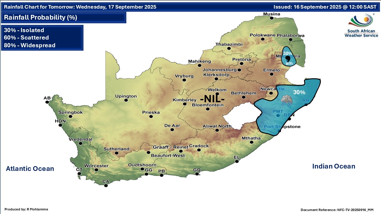
Maps for Wednesday 17 September
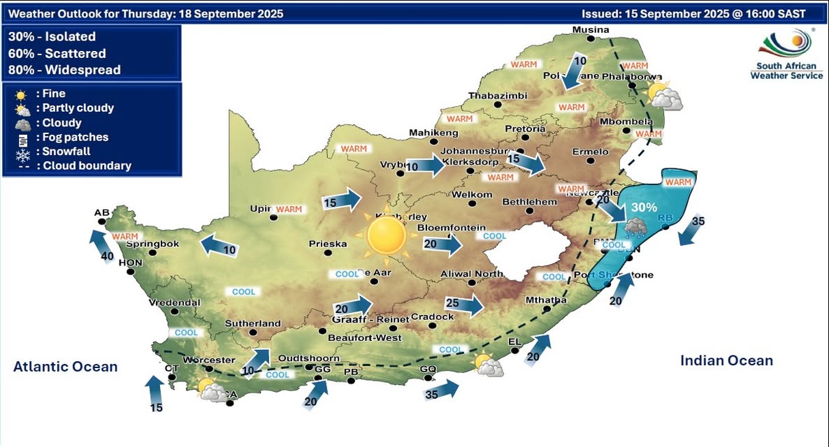
  Maps for Thursday 18 September
|