
   Maps partly based on data from the SA Weather Service
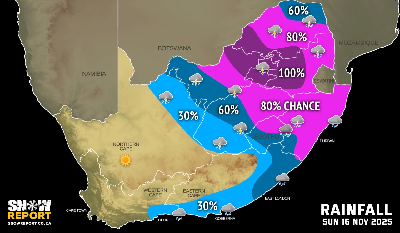
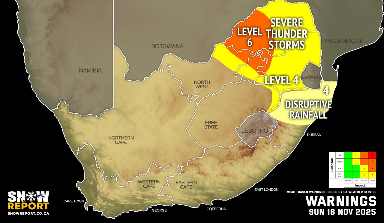
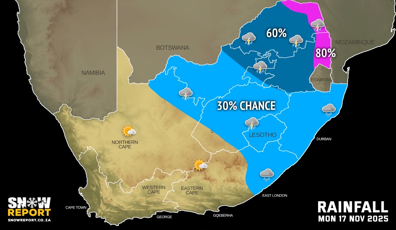
SUNDAY WEATHER: Level 9 warning for rainfall resulting in possible widespread flooding with severe impactsBy Staff WriterPublished: 15 November 2025 [updated 16 November] This forecast is for: Sun 16 November 2025 The maps cover: Sun 16 Nov – Mon 17 Nov
The latest forecast is available by clicking here. The SA Weather Service (SAWS) has advised that the central and eastern parts of South Africa are expected to experience a severe weather event from the weekend into the following week due to an intense weather system that includes a cut-off low (COL). According to the SA Weather Services, a high likelihood of significant impacts are expected due to severe thunderstorms with heavy rain across Gauteng and Mpumalanga Highveld from early on Sunday morning, continuing during the course of the day. Rainfall accumulations of 100-150 mm are predicted for both provinces. As much as 10cm of snow or sleet is possible for the Drakensberg in the early hours of Sunday, but it is very likely that it will melt quickly due to all the rain. If you're hiking or driving through the east of Lesotho on Sunday you might want to take note of this forecast. UPDATED Warnings from the SA Weather Service for Sunday: A. level 6 warning severe thunderstorms over northern Gauteng and the western parts of Limpopo, with a high risk of damaging winds, hail and heavy downpours. B. level 4 warning severe thunderstorms over parts of North West, Gauteng, Limpopo, Mpumalanga and the Free State, as per the map above. C. level 4 warning disruptive rainfall over KwaZulu-Natal, as per the map above. The map for impact warnings above has been updated. Regional forecasts from the SA Weather Service for Sunday: GAUTENG Cloudy and cool with widespread showers and thundershowers. MPUMALANGA Cloudy and cold to cool with widespread showers and thundershowers. LIMPOPO Cloudy and cool with widespread showers and thundershowers but scattered in the Limpopo Valley. NORTH-WEST Cloudy and cool to warm with widespread showers and thundershowers but scattered in the west. It will become partly cloudy in the west by afternoon. THE FREE STATE Partly cloudy with isolated showers and thundershowers in the south, otherwise cloudy and cool to warm with scattered to widespread showers and thundershowers. It will be cold in the east. THE NORTHERN CAPE Fine and cool in the west, otherwise partly cloudy and warm with isolated showers and thundershowers in the extreme east. THE WESTERN CAPE Partly in the east with light rain along the south coast and adjacent interior in the morning, otherwise fine and warm to hot. The wind along the coast will be fresh south-easterly but strong along the west coast. THE WESTERN HALF OF THE EASTERN CAPE Cloudy and cool with isolated showers and rain along the coast and adjacent interior, becoming partly cloudy in places by the afternoon, but fine in the north. The wind along the coast will be light to moderate southerly, becoming south-easterly in the afternoon. THE EASTERN HALF OF THE EASTERN CAPE Cloudy and cool, but cold in places with scattered showers and rain, but isolated in the north. The wind along the coast will be light to moderate south-easterly. KWAZULU-NATAL Cloudy and cold to cool with widespread showers and thundershowers, but scattered in the extreme south-west. The wind along the coast will be light to moderate southerly to south-westerly. Travellers forecasts from the SA Weather Service for Sunday: PRETORIA Cloudy with widespread showers and thundershowers. Minimum/Maximum: 15/19°C JOHANNESBURG Cloudy with widespread showers and thundershowers. Minimum/Maximum: 15/18°C VEREENIGING Cloudy with widespread showers and thundershowers. Minimum/Maximum: 16/18°C MBOMBELA Cloudy with widespread showers and thundershowers. Minimum/Maximum: 13/20°C POLOKWANE Cloudy with widespread showers and thundershowers. Minimum/Maximum: 15/19°C MAHIKENG Cloudy with widespread showers and thundershowers. Minimum/Maximum: 16/21°C VRYBURG Cloudy with scattered showers and thundershowers, becoming partly cloudy by afternoon. Minimum/Maximum: 16/23°C BLOEMFONTEIN Partly cloudy with isolated showers and thundershowers. Minimum/Maximum: 13/23°C KIMBERLEY Partly cloudy with isolated showers and thundershowers. Minimum/Maximum: 13/26°C UPINGTON Partly cloudy. Minimum/Maximum: 16/29°C CAPE TOWN Fine. Wind: Moderate to fresh south-easterly becoming strong from the afternoon. Minimum/Maximum: 16/26°C GEORGE Cloudy with light rain in the morning, otherwise partly cloudy. Wind: Light and variable becoming moderate southerly to south-easterly from the afternoon. Minimum/Maximum: 13/20°C GQEBERHA Cloudy with isolated early morning showers and rain, becoming partly cloudy in the afternoon. Wind: Moderate southerly, becoming south-easterly in the afternoon. Minimum/Maximum: 16/20°C EAST LONDON Cloudy with scattered morning showers and rain Wind: Light to moderate south-westerly, becoming south-easterly in the afternoon. Minimum/Maximum: 15/20°C DURBAN Cloudy with widespread showers and rain. Wind: Light to moderate southerly to south-westerly. Minimum/Maximum: 17/19°C RICHARDS BAY Cloudy with widespread showers and rain Wind: Light to moderate southerly to south-westerly. Minimum/Maximum: 18/20°C PIETERMARITZBURG Cloudy with widespread showers and rain. Minimum/Maximum: 12/15°C This forecast is usually updated a few times per day.
Please be sure to send photos and videos to us via whatsapp and also tell us where and when they were taken. Follow our channels
|