
    Swipe left or right for more maps, and see below for others
Severe thunderstorm warnings issued for Mpumalanga and KZN on SaturdayBy Staff WriterPublished: 15 August 2025 [updated 16 August] This forecast is for: Sat 16 August 2025 The maps cover: Sat 16 Aug – Mon 18 Aug
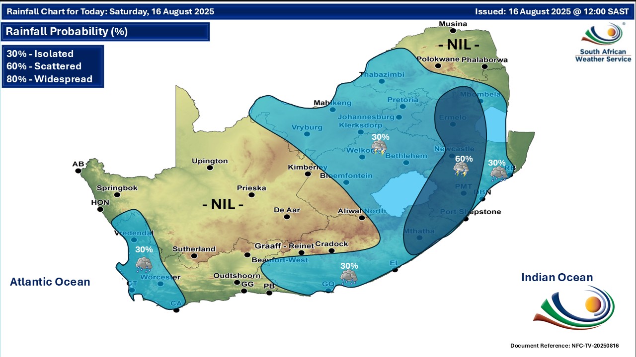
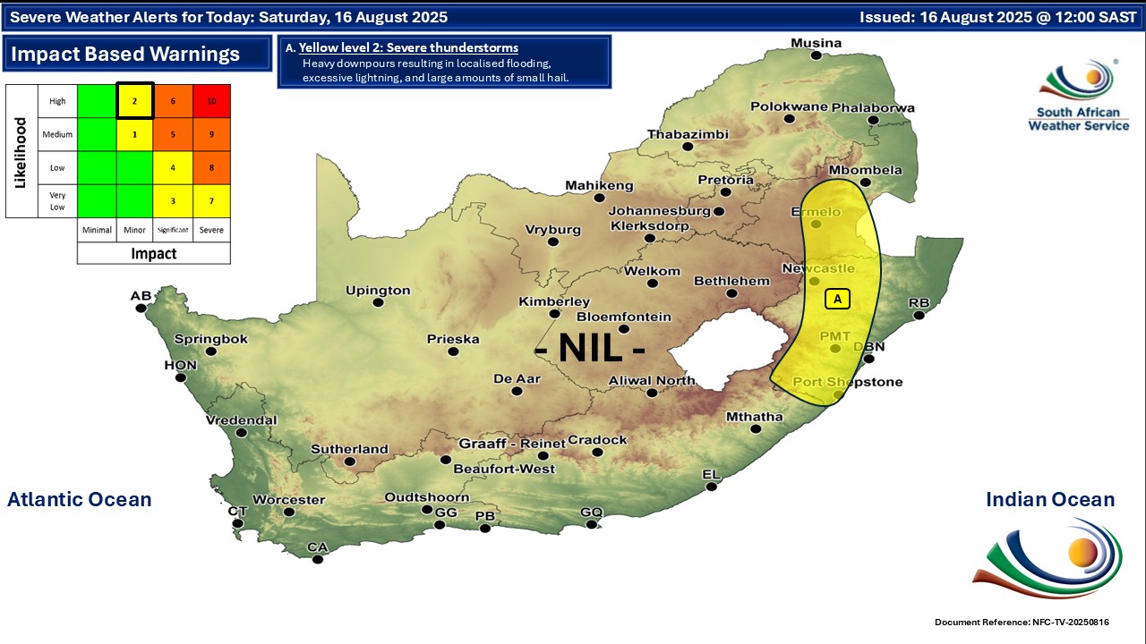
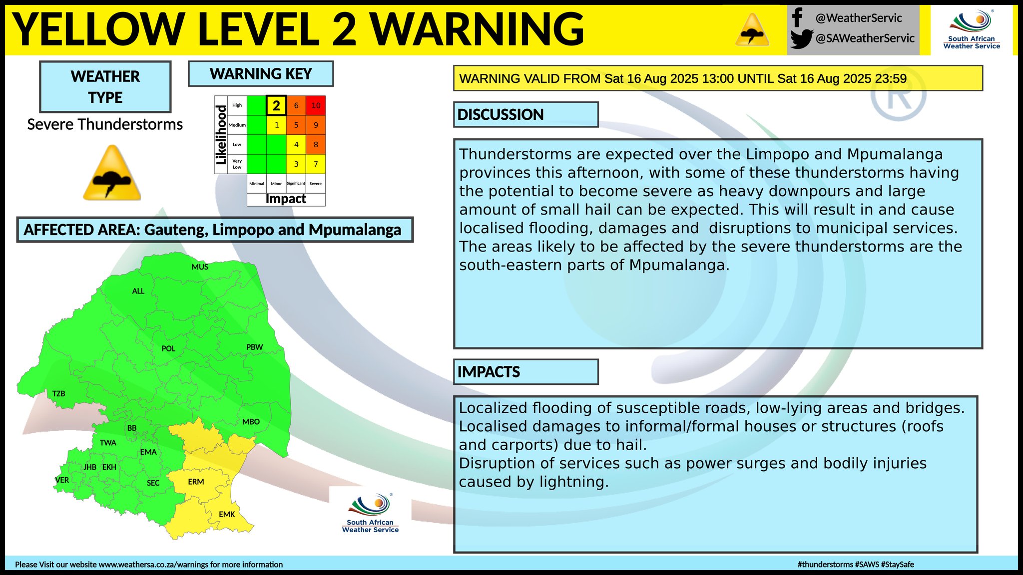
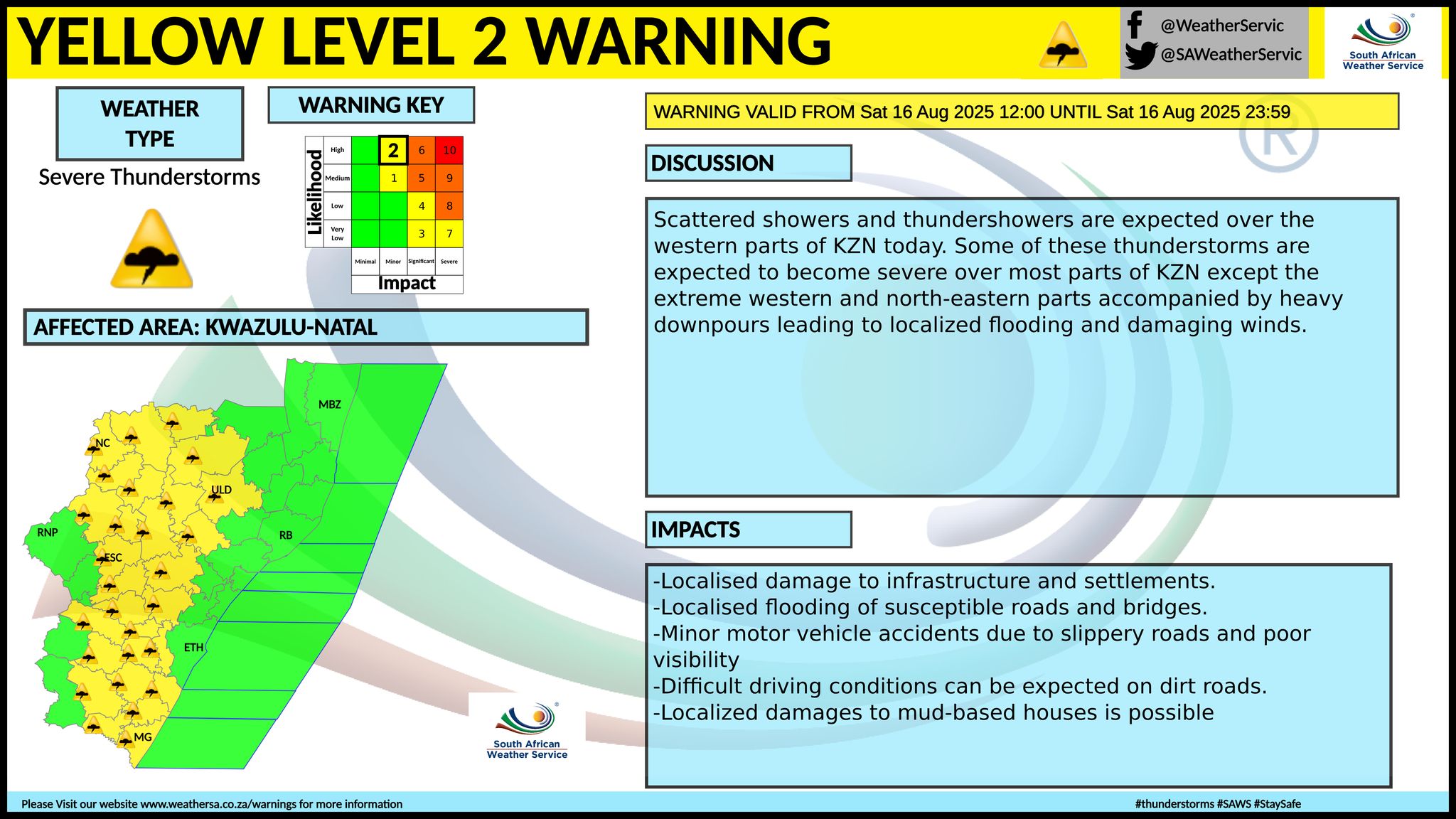
A newer forecast is available by clicking here. You can listen to this daily weather forecast as a 3 minute podcast by pressing the > play button above. There will be morning fog in many areas in South Africa on Saturday. From Sunday it should be fine over the western interior, otherwise partly cloudy and cool to warm with isolated showers and thundershowers in the east. SEE ALSO: More snowfall possible for the Eastern Cape and Lesotho until the weekend (from 14 August). Warnings from the SA Weather Service for Saturday: level 2 warning for severe thunderstorms for parts of Mpumalanga and KwaZulu-Natal as per the maps above. Extremely high fire danger conditions are expected over Naledi local municipality in the North West and over Lephalale local municipality in Limpopo. Regional forecasts from the SA Weather Service for Saturday: GAUTENG Partly cloudy at first, otherwise cloudy and cool, but warm in the extreme north. Isolated afternoon showers and thundershowers are expected. The expected UVB sunburn index: High MPUMALANGA Morning drizzle and fog along the escarpment, otherwise partly cloudy and cool, but cloudy in the south-east. Isolated to scattered showers and thundershowers are expected from the afternoon, except in the north-east. LIMPOPO Cloudy in the morning in the south and central, otherwise partly cloudy and cool with afternoon isolated showers and thundershowers except in the Lowveld. NORTH WEST Partly cloudy and cool to warm, becoming cloudy in the east by the afternoon, with isolated showers and thundershowers. THE FREE STATE Cloudy in the east, otherwise partly cloudy and cool to warm, with isolated showers and thundershowers, except in the south-west. THE NORTHERN CAPE Morning fog patches over the western and southern parts, otherwise partly cloudy and cool. The wind along the coast will be light to moderate north-westerly, becoming westerly to south-westerly in the afternoon. THE WESTERN CAPE Morning fog patches over the southern parts, otherwise cloudy to partly cloudy and cool to cold with light rain over the western and south-western parts. The wind along the coast will be light to moderate north-westerly, but moderate to fresh south-westerly along the south coast. The expected UVB sunburn index: Low THE WESTERN HALF OF THE EASTERN CAPE Morning fog patches in places over the interior, otherwise partly cloudy and cool with isolated showers and thundershowers in places, but cloudy along the coast. It will become fine in the west by evening. The wind along the coast will be moderate to fresh south-westerly, becoming light and variable in the evening. THE EASTERN HALF OF THE EASTERN CAPE Morning fog patches in places in the west, otherwise cloudy and cool with isolated showers and thundershowers, but scattered south-east of the escarpment. The wind along the coast will be moderate to fresh south-westerly, but fresh to strong north-easterly north of Kei Mouth. KWAZULU-NATAL Morning fog patches in places over the northern interior, otherwise partly cloudy and cool to warm with isolated to scattered showers and thundershowers except in the extreme north-east. It will be cloudy in the west. The wind along the coast will be moderate to fresh easterly to north-easterly. The expected UVB sunburn index: Low Travellers forecasts from the SA Weather Service for Saturday: PRETORIA Partly cloudy at first, otherwise cloudy with isolated showers and thundershowers by the afternoon. Minimum/Maximum: 10/24°C The expected UVB Sunburn Index: High JOHANNESBURG Partly cloudy at first, otherwise cloudy with isolated showers and thundershowers by the afternoon. Minimum/Maximum: 08/22°C VEREENIGING Partly cloudy at first, otherwise cloudy with isolated showers and thundershowers by the afternoon. Minimum/Maximum: 05/22°C MBOMBELA Partly cloudy with isolated showers and thundershowers by the afternoon. Minimum/Maximum: 12/22°C POLOKWANE Fine at first, otherwise partly cloudy with isolated showers and thundershowers by the evening. Minimum/Maximum: 05/21°C MAHIKENG Partly cloudy, with isolated showers and thundershowers. Minimum/Maximum: 11/25°C VRYBURG Partly cloudy, with isolated showers and thundershowers. Minimum/Maximum: 10/25°C BLOEMFONTEIN Partly cloudy, with isolated showers and thundershowers. Minimum/Maximum: 10/21°C KIMBERLEY Partly cloudy. Minimum/Maximum: 10/22°C UPINGTON Partly cloudy. Minimum/Maximum: 06/20°C CAPE TOWN Cloudy with light rain. Wind: Fresh northerly to north-westerly. Minimum/Maximum: 11/17°C The expected UVB Sunburn Index: Low GEORGE Partly cloudy at first, otherwise cloudy. Wind: Light to moderate south-westerly. Minimum/Maximum: 11/19°C GQEBERHA Cloudy with isolated showers and thundershowers, becoming partly cloudy by the late afternoon. Wind: Moderate to fresh south-westerly, becoming light and variable from the evening. Minimum/Maximum: 14/20°C EAST LONDON Fog possible in the morning, otherwise cloudy with isolated showers and thundershowers. Wind: Moderate to fresh south-westerly, becoming light in the evening. Minimum/Maximum: 15/22°C DURBAN Partly cloudy with isolated evening showers and thundershowers. Wind: Moderate to fresh northerly to north-easterly, reaching strong in the afternoon. Minimum/Maximum: 19/24°C The expected UVB Sunburn Index: Low RICHARDS BAY Partly cloudy with isolated evening showers and thundershowers. Wind: Moderate to fresh northerly to north-easterly. Minimum/Maximum: 18/26°C PIETERMARITZBURG Partly cloudy with isolated afternoon showers and thundershowers. Minimum/Maximum: 11/26°C This forecast is usually updated a few times per day.
Please be sure to send photos and videos to us via whatsapp and also tell us where and when they were taken. Follow our channels
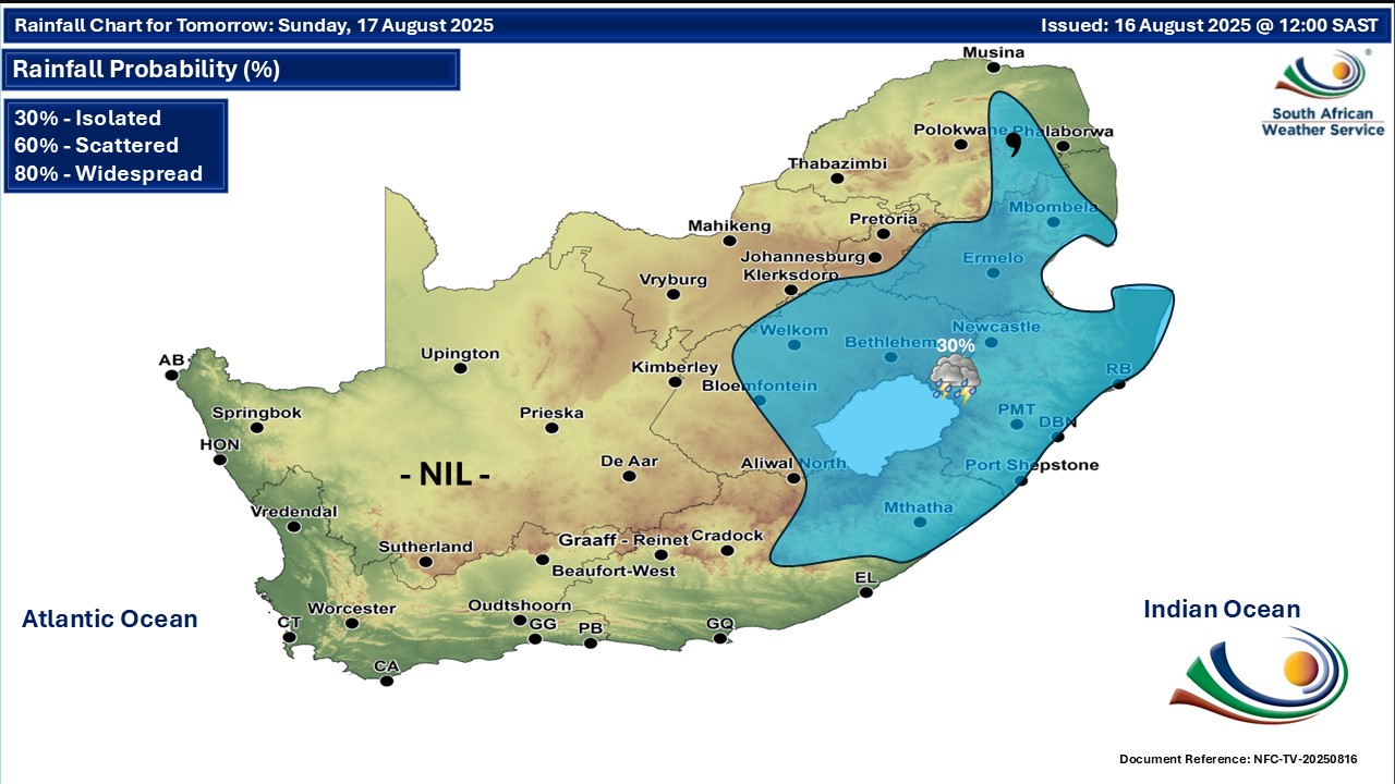
Maps for Sunday 17 August
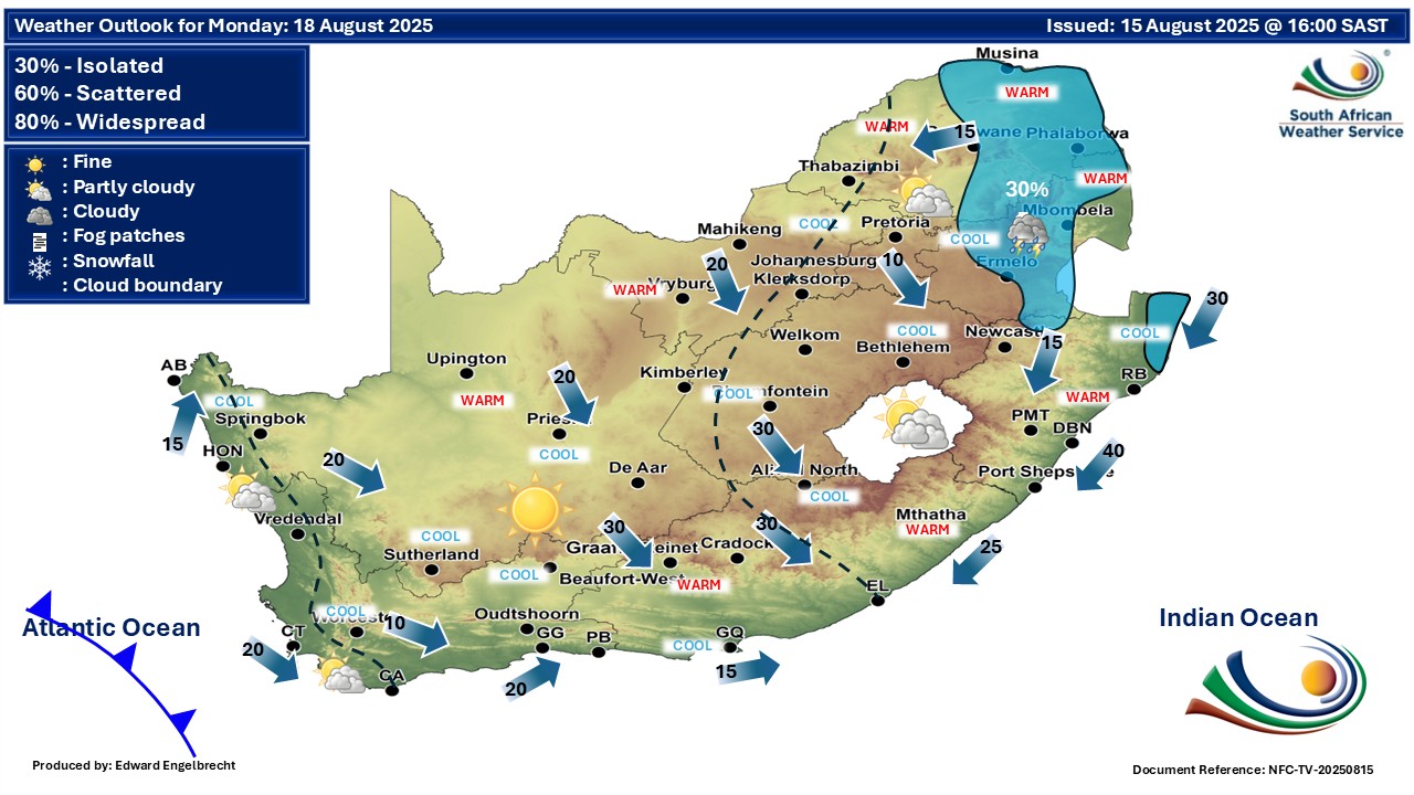
 Maps for Monday 18 August
|