


THURSDAY WEATHER: LEVEL 10 warning – high likelihood of severe flooding related impacts in Mpumalanga and Limpopo
By Staff WriterPublished: 14 January 2026 [updated 15 January]
This forecast is for: Thu 15 January 2026
The maps cover: Thu 15 Jan – Fri 16 Jan
| SHARE TO |
The latest forecast is available by clicking here.
Heavy rainfall is expected to persist for the next two days over the eastern parts of Limpopo and Mpumalanga due to the tropical weather system. Weather models indicate another 100-200mm accumulated rainfall over the next two days, in regions that are already saturated with overflowing rivers and dams.
According to the SA Weather Service, further heavy rainfall of approximately 100 up to 200 mm is possible over Maruleng and Ba-Phalaborwa Local Municipalities, Nkomazi Local Municipality, City of Mbombela, Bushbuckridge Local Municipality, Greater Giyani, Greater Tzaneen, Greater Letaba and Collins Chabane.
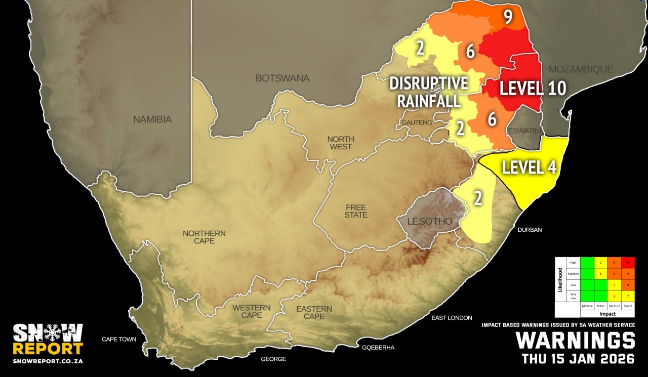
Warnings from the SA Weather Service for Thursday:
level 10 warning for disruptive rainfall over parts of Limpopo and Mpumalanga leading to a high likelihood of severe flooding related impacts on Thursday and Friday.
A. level 9 warning for disruptive rainfall resulting in widespread flooding of roads and settlements, widespread mudslides, rockfalls and soil erosion, danger to life due to fast flowing stream, widespread damage to property, building and loss of livelihood and livestock as well as possible widespread displacement of affected communities over the eastern parts of Limpopo (Vhembe and Mopani District Municipalities) and over Mpumalanga Lowveld and escarpment (Ehlanzeni District Municipality).
B. level 6 warning for disruptive rainfall resulting in flooding of roads and settlements (formal and informal), mudslides rockfalls and soil erosion, danger to life due to fast flowing stream, damage to property, infrastructure, loss of Livelihood and livestock over the central parts of Limpopo (parts of Capricorn and Sekhukhune District Municipalities) and eastern Highveld of Mpumalanga (Emakhazeni, Msukaligwa, Mkhondo and Chief Albert Luthuli local Municipalities).
C. level 4 warning for disruptive rainfall with heavy downpours leading to flooding of roads and settlements, displacement of affected communities, major disruption of traffic flow due to major roads being flooded or closed is expected over the north-eastern parts of KwaZulu-Natal.
D. level 2 warning for disruptive rainfall resulting in localised flooding of susceptible formal/informal settlements or roads, low-lying areas and bridges, localised mudslides, rockfalls and soil erosion in places over the central parts of Mpumalanga and western parts of Limpopo, excluding the extreme south-western parts.
E. level 2 warning for severe thunderstorms with heavy downpours, damaging winds, large amounts of hail and excessive lighting leading to localised flooding and damage to settlements and infrastructure over the western parts of KwaZulu-Natal.
Extremely high fire danger conditions are expected over parts of the Northern Cape and the western Free State.
Regional forecasts from the SA Weather Service for Thursday:
GAUTENG
Cloudy and warm with isolated showers and thundershowers.
MPUMALANGA
Morning fog patches along the escarpment, otherwise cloudy and cool to warm with isolated to scattered showers and thundershowers but widespread in the east.
LIMPOPO
Cloudy and cool to warm with isolated to scattered showers and thundershowers, but widespread in the east.
NORTH WEST
Partly cloudy and hot with isolated afternoon thundershowers.
THE FREE STATE
Partly cloudy and hot with isolated afternoon thundershowers.
THE NORTHERN CAPE
Fine in the central parts, otherwise partly cloudy and cool to warm but hot in the north-east with isolated thundershowers in the extreme east. The wind along the coast will be fresh to strong southerly to south-easterly.
THE WESTERN CAPE
Cloudy along the south coast and adjacent interior, otherwise partly cloudy and cool to warm with isolated showers and rain in the west and south but scattered along the south coast. The wind along the coast will be moderate to fresh southerly to south-easterly but strong along the west and south-west coast.
THE WESTERN HALF OF THE EASTERN CAPE
Cloudy and cool to warm with isolated showers and rain but scattered along the coast. The wind along the coast will be fresh to strong southerly to south-easterly.
THE EASTERN HALF OF THE EASTERN CAPE
Cloudy and cool to warm with scattered showers and thundershowers. The wind along the coast will be fresh to strong south-westerly, becoming southerly to south-easterly from the afternoon.
KWAZULU-NATAL
Morning fog patches over the southern and western interior, otherwise partly cloudy to cloudy and warm. Scattered showers and thundershowers are expected but widespread in the north-east. The wind along the coast will be moderate to fresh northerly to north-easterly, becoming light to moderate southerly to south-westerly in the south from late morning, spreading northwards while reaching fresh in places.
Travellers forecasts from the SA Weather Service for Thursday:
PRETORIA
Cloudy with isolated showers and thundershowers.
Minimum/Maximum: 16/30°C
JOHANNESBURG
Cloudy with isolated showers and thundershowers.
Minimum/Maximum: 14/27°C
VEREENIGING
Cloudy with isolated showers and thundershowers.
Minimum/Maximum: 15/29°C
MBOMBELA
Fog patches in the morning, otherwise cloudy with widespread showers and thundershowers.
Minimum/Maximum: 18/22°C
POLOKWANE
Cloudy with scattered showers and thundershowers.
Minimum/Maximum: 18/25°C
MAHIKENG
Partly cloudy with isolated afternoon thundershowers.
Minimum/Maximum: 17/32°C
VRYBURG
Partly cloudy with isolated afternoon thundershowers.
Minimum/Maximum: 21/34°C
BLOEMFONTEIN
Partly cloudy with isolated afternoon thundershowers.
Minimum/Maximum: 20/35°C
KIMBERLEY
Partly cloudy with isolated afternoon thundershowers.
Minimum/Maximum: 18/34°C
UPINGTON
Fine.
Minimum/Maximum: 17/36°C
CAPE TOWN
Cloudy with a chance of light rain at first, becoming partly cloudy in the afternoon.
Wind: Fresh to strong southerly to south-easterly.
Minimum/Maximum: 16/23°C
GEORGE
Cloudy with intermittent rain.
Wind: Light and variable at first otherwise moderate to fresh southerly to south-easterly.
Minimum/Maximum: 16/21°C
GQEBERHA
Cloudy with scattered showers and rain.
Wind: Fresh to strong southerly to south-easterly.
Minimum/Maximum: 19/26°C
EAST LONDON
Cloudy with scattered showers and rain.
Wind: Fresh to strong south-westerly, becoming southerly to south-easterly from the afternoon.
Minimum/Maximum: 19/26°C
DURBAN
Cloudy with scattered showers and thundershowers.
Wind: Moderate to fresh northerly to north-easterly, becoming light to moderate southerly to south-westerly from late morning, reaching fresh in the afternoon.
Minimum/Maximum: 23/28°C
RICHARDS BAY
Cloudy with widespread showers and rain.
Wind: Moderate to fresh northerly to north-easterly, becoming light to moderate south-westerly in the afternoon.
Minimum/Maximum: 24/32°C
PIETERMARITZBURG
Cloudy with scattered showers and thundershowers.
Minimum/Maximum: 19/27°C
This forecast is usually updated a few times per day.
| SHARE TO |
Please be sure to send photos and videos to us via whatsapp and also tell us where and when they were taken.
Follow our channels