

SUNDAY WEATHER: Cold in the eastern part of SA and a chance of some snowfall in the Drakensberg overnight
By Staff WriterPublished: 14 February 2026
This forecast is for: Sun 15 February 2026
The maps cover: Sun 15 Feb – Sun 15 Feb
| SHARE TO |
The latest forecast is available by clicking here.
Very hot to extremely hot conditions are expected over the western parts of Northern Cape, West Coast District, City of Cape Town and the western parts of the Cape Winelands on Sunday and Monday.
Morning fog is likely in a few parts of Mpumalanga, the Eastern Cape and KwaZulu-Natal.
The data currently indicates a chance of some very light snowfall in the highest parts of the Drakensberg in Lesotho from late on Saturday and into the early hours of Sunday morning.
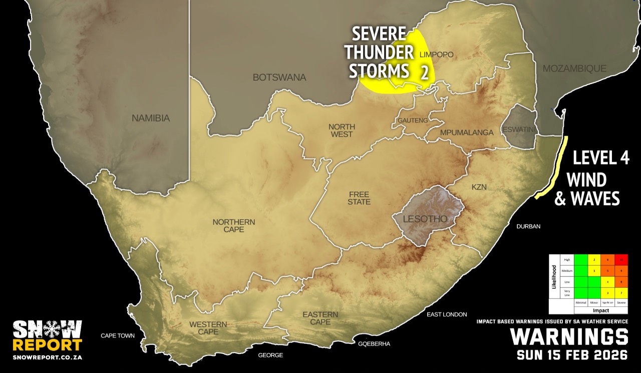
Warnings from the SA Weather Service for Sunday:
A. level 4 warning for damaging winds and waves associated with heavy downpours leading to localised flooding of susceptible roads, settlements, low-lying bridges/areas, large amounts of small hail, with possible strong damaging winds and excessive lightning, are anticipated over the Western Bushveld of Limpopo and the extreme eastern parts of the North West.
B. level 2 warning for severe thunderstorms leading to localised disruption of small harbours or port for a short period of time and damage of settlements and infrastructure are expected over the northern parts of KwaZulu-Natal.
Extremely high fire danger conditions are expected over the Kamiesberg and Hantam municipalities of the Northern Cape, the Matzikama, Cederberg, Witzenberg and Prins Albert municipalities of the Western Cape.
Regional forecasts from the SA Weather Service for Sunday:
GAUTENG
Cloudy and cool with isolated showers and thundershowers.
MPUMALANGA
Morning fog patches in places along the escarpment, otherwise cloudy and cold to cool with isolated showers and thundershowers.
LIMPOPO
Cloudy and cool to warm with isolated showers and thundershowers, but scattered in the west and central parts.
NORTH-WEST
Cloudy and warm to hot, with isolated showers and thundershowers.
THE FREE STATE
Partly cloudy and warm, but cloudy in the east with isolated showers and thundershowers in the east and north-eastern parts.
6. EASTERN PARTS OF THE NORTHERN CAPE
Fine to partly cloudy and warm to hot, with isolated showers and thundershowers in the north.
THE NORTHERN CAPE
Partly cloudy in the east and central where isolated showers and thundershowers can be expected in places, otherwise fine and warm to hot but very hot in places over the south-west coast. The wind along the coast will be fresh to strong southerly to south-easterly.
THE WESTERN CAPE
Fine and warm to hot but very hot in places over the west coast and western parts of Cape Winelands districts, but cool in places along the south coast and the Cape Peninsula. The wind along the coast will be light to moderate southerly along the west coast in the morning, otherwise fresh to strong easterly to south-easterly, reaching gale along the south-west coast at times.
THE WESTERN HALF OF THE EASTERN CAPE
Fine in the west, otherwise partly cloudy and warm but cloudy along the coast. The wind along the coast will be moderate to fresh easterly, becoming north-easterly by the evening.
THE EASTERN HALF OF THE EASTERN CAPE
Morning fog in places, otherwise partly cloudy cool to warm with isolated showers and rain in the east. The wind along the coast will be light to moderate easterly becoming north-easterly in the evening.
KWAZULU-NATAL
Morning fog patches in places in the interior, otherwise cloudy and cool to warm with isolated showers and thundershowers. The wind along the coast will be light to moderate north-easterly south of Durban, otherwise southerly to south-easterly.
Travellers forecasts from the SA Weather Service for Sunday:
PRETORIA
Cloudy with isolated showers and thundershowers.
Minimum/Maximum: 14/23°C
JOHANNESBURG
Cloudy with isolated showers and thundershowers.
Minimum/Maximum: 13/20°C
VEREENIGING
Cloudy with isolated showers and thundershowers.
Minimum/Maximum: 14/22°C
MBOMBELA
Cloudy with isolated showers and thundershowers.
Minimum/Maximum: 16/21°C
POLOKWANE
Partly cloudy at first, otherwise cloudy with scattered showers and thundershowers.
Minimum/Maximum: 15/22°C
MAHIKENG
Partly cloudy, with Isolated showers and thundershowers.
Minimum/Maximum: 16/26°C
VRYBURG
Partly cloudy, with isolated showers and thundershowers.
Minimum/Maximum: 17/28°C
BLOEMFONTEIN
Partly cloudy.
Minimum/Maximum: 13/28°C
KIMBERLEY
Partly cloudy.
Minimum/Maximum: 13/30°C
UPINGTON
Partly cloudy, with isolated showers and thundershowers.
Minimum/Maximum: 17/35°C
CAPE TOWN
Fine.
Wind: Moderate to fresh southerly to south-easterly.
Minimum/Maximum: 16/32°C
GEORGE
Fine.
Wind: Fresh to strong easterly to south-easterly.
Minimum/Maximum: 14/23°C
GQEBERHA
Cloudy.
Wind: Moderate to fresh easterly, becoming north-easterly in the evening.
Minimum/Maximum: 16/24°C
EAST LONDON
Cloudy.
Wind: Light and variable in the morning, otherwise light to moderate easterly becoming north-easterly in the evening.
Minimum/Maximum: 15/24°C
DURBAN
Cloudy with scattered showers and thundershowers.
Wind: Moderate to fresh south-westerly to southerly.
Minimum/Maximum: 19/25°C
RICHARDS BAY
Cloudy with scattered showers and thundershowers.
Wind: Moderate to fresh northerly to north-easterly at first, otherwise fresh to strong south-westerly.
Minimum/Maximum: 21/24°C
PIETERMARITZBURG
Morning fog, otherwise cloudy with scattered showers and thundershowers.
Minimum/Maximum: 13/21°C
This forecast is usually updated a few times per day.
| SHARE TO |
Please be sure to send photos and videos to us via whatsapp and also tell us where and when they were taken.
Follow our channels