
  Maps partly based on data from the SA Weather Service
MONDAY WEATHER: Some rain possible and plenty of fog but a high fire risk in the western interiorBy Staff WriterPublished: 14 December 2025 [updated 15 December] This forecast is for: Mon 15 December 2025 The maps cover: Mon 15 Dec – Mon 15 Dec
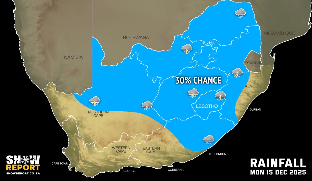
The latest forecast is available by clicking here. Isolated showers are possible on Monday but from Tuesday more rainfall is likely. Very hot and uncomfortable conditions are expected over the interior of Namakwa District in the Northern Cape, Cape Winelands, Central and Little Karoo, as well as the eastern parts of Overberg in the Western Cape. Extremely hot conditions are expected in places over Dr Beyers Naude, Blue Crane Route, Sundays River Valley and Raymond Mhlaba Local Municipalities in the Eastern Cape. Warnings from the SA Weather Service for Monday: Extremely high fire danger conditions are expected in places over the interior of the Northern Cape, the Cape Winelands, Central Karoo, Little Karoo and the eastern parts of Overberg in the Western Cape, as well as Dr Beyers Naude Local Municipality in the Eastern Cape. Regional forecasts from the SA Weather Service for Monday: GAUTENG Cloudy with morning fog in the south, otherwise partly cloudy and warm with isolated afternoon showers and thundershowers. MPUMALANGA Cloudy with morning fog on the escarpment areas, otherwise partly cloudy and warm but cool in places on the Highveld. Isolated showers and thundershowers are expected. LIMPOPO Cloudy with morning fog patches in the south-west and along the escarpment with drizzle, otherwise partly cloudy and warm with isolated showers and thundershowers. NORTH-WEST Cloudy with morning fog in places in the east, otherwise partly cloudy and warm with isolated showers and thundershowers in the afternoon. THE FREE STATE Cloudy with morning fog patches in the extreme east, otherwise partly cloudy and warm with isolated showers and thundershowers. THE NORTHERN CAPE Fine and warm to hot becoming partly cloudy in the central and eastern interior where isolated afternoon showers and thundershowers are expected. It will be very hot in places over the western interior. The wind along the coast will be moderate to fresh southerly but strong in the afternoon. THE WESTERN CAPE Fine and warm to hot but very hot in places over the central and eastern interior. It will become partly cloudy along the south coast and the north-eastern interior from the afternoon. The wind along the coast will be light and variable along the south-west and south coast in the morning, otherwise moderate to fresh southerly to south-westerly but light to moderate south-easterly along the south coast. THE WESTERN HALF OF THE EASTERN CAPE Partly cloudy and warm along the coast, otherwise fine and hot to very hot. It will be extremely hot in places over the interior. The wind along the coast will be light and variable at first, otherwise light to moderate south-westerly, becoming southerly in the afternoon. THE EASTERN HALF OF THE EASTERN CAPE Cloudy with morning fog patches over the interior, otherwise partly cloudy and warm to hot with isolated showers and thundershowers over the interior, spreading to the Wild Coast, north of Coffee Bay in the evening. The wind along the coast will be light northerly at first, otherwise moderate to fresh north-easterly, becoming light south-easterly in the south from late morning, but south-westerly in the evening. KWAZULU-NATAL Cloudy with morning fog patches over the interior, otherwise partly cloudy and warm to hot with isolated afternoon showers and thundershowers in the west and extreme south. The wind along the coast will be light southerly to south-westerly in the extreme north, otherwise light to moderate northerly to north-easterly, but fresh in places. Travellers forecasts from the SA Weather Service for Monday: PRETORIA Partly cloudy with isolated afternoon showers and thundershowers. Minimum/Maximum: 15/28°C JOHANNESBURG Partly cloudy with isolated afternoon showers and thundershowers. Minimum/Maximum: 14/25°C VEREENIGING Partly cloudy with isolated afternoon showers and thundershowers. Minimum/Maximum: 14/25°C MBOMBELA Morning fog, otherwise partly cloudy with isolated afternoon showers and thundershowers. Minimum/Maximum: 17/27°C POLOKWANE Partly cloudy with isolated afternoon showers and thundershowers. Minimum/Maximum: 16/25°C MAHIKENG Morning fog patches, otherwise partly cloudy with isolated showers and thundershowers. Minimum/Maximum: 16/26°C VRYBURG Partly cloudy with isolated showers and thundershowers. Minimum/Maximum: 16/29°C BLOEMFONTEIN Partly cloudy with isolated showers and thundershowers. Minimum/Maximum: 14/28°C KIMBERLEY Fine, becoming partly cloudy with isolated showers and thundershowers. Minimum/Maximum: 17/31°C UPINGTON Fine becoming partly cloudy. Minimum/Maximum: 19/35°C CAPE TOWN Fine. Wind: Light and variable in the morning, otherwise light to moderate southerly to south-westerly. Minimum/Maximum: 16/28°C GEORGE Fine. Wind: Light and variable in the morning, otherwise light to moderate south-easterly. Minimum/Maximum: 13/25°C GQEBERHA Partly cloudy. Wind: Light to moderate south-westerly, becoming moderate southerly from midday. Minimum/Maximum: 14/26°C EAST LONDON Partly cloudy. Wind: Light northerly, becoming south-easterly late morning, but south-westerly in the evening. Minimum/Maximum: 15/28°C DURBAN Partly cloudy becoming fine. Wind: Light to moderate northerly to north-easterly. Minimum/Maximum: 19/30°C RICHARDS BAY Partly cloudy becoming fine. Wind: Light to moderate northerly to north-easterly. Minimum/Maximum: 20/33°C PIETERMARITZBURG Partly cloudy. Minimum/Maximum: 15/31°C This forecast is usually updated a few times per day.
Please be sure to send photos and videos to us via whatsapp and also tell us where and when they were taken. Follow our channels
|