
MONDAY WEATHER: Six warnings issued for disruptive rain, thunderstorms, wind and waves – flooding possible
 By Staff Writer
Published: 13 September 2026
This forecast is for: Mon 14 September 2026
The maps cover: Mon 14 Sep – Mon 14 Sep
| SHARE TO |
The latest forecast is available by clicking here.
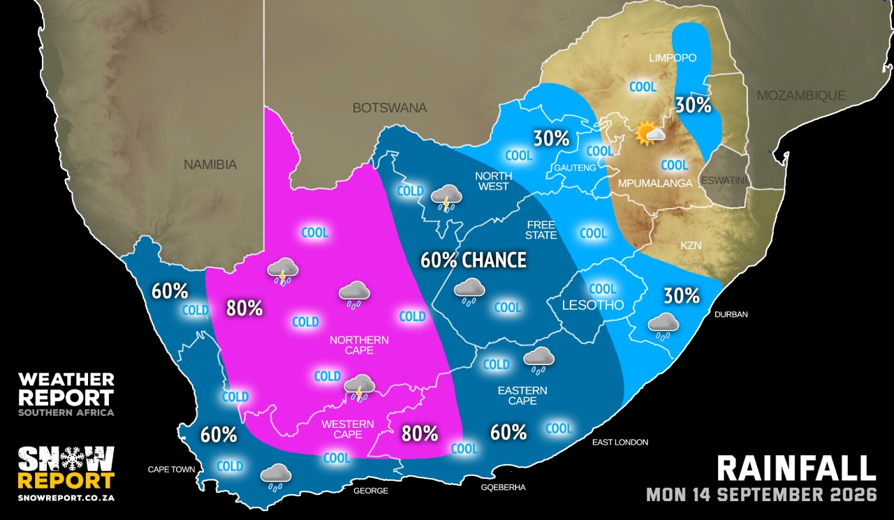
A cut-off low pressure system developing west of the country is expected to affect the Western Cape and Northern Cape from Sunday into Monday.
The public and small stock farmers are advised of intermittent showers and thundershowers accompanied heavy downpours at times with possible large amounts of small hail and lightning, a significant drop in temperatures over the high-lying areas, windy coastal and interior conditions as well as very rough seas (reaching 4m to 4.5m south of Table Bay).
SEE ALSO: Snow possible for Lesotho and South Africa from Wednesday until the weekend – potentially heavy.
SEE ALSO: More snow on the radar for Lesotho and some peaks in South Africa on Monday and Tuesday.
Warnings from the SA Weather Service:
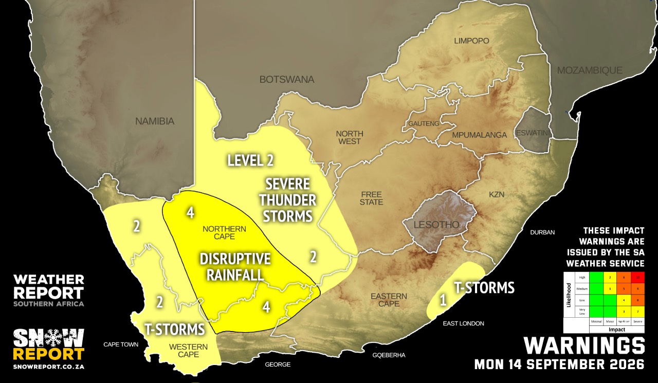
A. level 4 warning for disruptive rainfall leading to flooding of roads and settlements, major disruption of traffic flow over the eastern Namakwa of the Northern Cape, the Central Karoo District of the Western Cape.
B. level 2 warning for severe thunderstorms with excessive lightning leading to localised injuries (human and livestock) and service disruption due to power disruptions over the Nama Khoi and Kamiesberg municipalities of the Northern Cape, the West Coast, Cape Winelands, Overberg Districts, as well as the City of Cape Town of the Western Cape.
C. level 2 warning for severe thunderstorms resulting in localised damage to settlements and temporary structures, localised disruption to power and communication in places over the north-eastern coast and adjacent interior of the Eastern Cape.
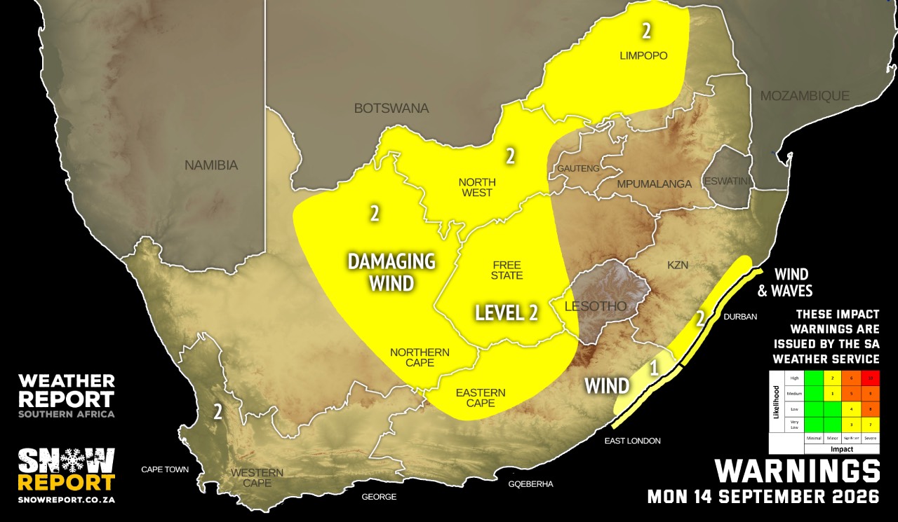
D. level 2 warning for damaging wind resulting in damages to informal settlements, power and communication disruption over the North West province, eastern parts of the Northern Cape, the central and the western parts of the Free State province, central and western parts of Limpopo and in places over the northern parts of the Eastern Cape.
E. level 1 warning for damaging wind and waves resulting in localised disruption of small harbours and/or ports for a short period of time, difficulty in navigation and localised damage to infrastructure and settlements between Port Edward and Richards Bay and the adjacent interior.
F. level 2 warning for damaging wind resulting in localised damage to settlements, localised interruption to power and communications and difficulty in navigation in places over extreme north-eastern parts of the Eastern Cape coast and adjacent interior.
Extremely high fire danger conditions are expected over the Western parts of the Waterberg District and the Blouberg municipality of Limpopo.
Regional forecasts from the SA Weather Service:
GAUTENG
Partly cloudy and cool to warm with isolated showers and thundershowers.
MPUMALANGA
Cloudy in the east with morning drizzle and fog patches in places over the eastern Highveld and the escarpment, otherwise partly cloudy and cool to warm with isolated showers and thundershowers in the extreme south-western parts.
LIMPOPO
Cloudy with morning drizzle along the escarpment, otherwise partly cloudy and cool to warm with isolated showers and thundershowers in the south-western Bushveld. It will be fine in paces over the north-western parts.
NORTH-WEST
Partly cloudy, windy and cool to warm with scattered showers and thundershowers but isolated in the east.
THE FREE STATE
Partly cloudy, windy and cool to warm with scattered showers and thundershowers but isolated in the north-east.
THE NORTHERN CAPE
Cloudy, windy and cool to cold with scattered showers and thundershowers but widespread in the east and central. The wind along the coast will be moderate to fresh north-westerly.
THE WESTERN CAPE
Cloudy and cool to cold with scattered showers and thundershowers but widespread over the north-eastern parts. The wind along the coast will be moderate to fresh westerly to north-westerly.
THE WESTERN HALF OF THE EASTERN CAPE
Windy in the north, otherwise cloudy and cool to warm with scattered showers and thundershowers, but widespread in the north-west. The wind along the coast will be moderate to fresh north-easterly becoming moderate to fresh south-westerly from late morning.
THE EASTERN HALF OF THE EASTERN CAPE
Warm to hot with morning fog in places south of the escarpment, otherwise cloudy, windy and cool with scattered showers and thundershowers, but isolated in the north-east. The wind along the coast will be fresh to strong north-easterly, reaching gale force along the Wild Coast from the afternoon.
KWAZULU-NATAL
Morning fog patches over the interior, otherwise partly cloudy and cool to warm with isolated showers in the south. The wind along the coast will be moderate to fresh north-easterly.
Travellers forecasts from the SA Weather Service:
PRETORIA
Partly cloudy with isolated showers and thundershowers.
Minimum/Maximum: 12/26°C
JOHANNESBURG
Partly cloudy with isolated showers and thundershowers.
Minimum/Maximum: 10/25°C
VEREENIGING
Partly cloudy with isolated showers and thundershowers.
Minimum/Maximum: 11/26°C
MBOMBELA
Cloudy with morning drizzle and fog, becoming partly cloudy from the afternoon.
Minimum/Maximum: 12/23°C
POLOKWANE
Fine.
Minimum/Maximum: 12/24°C
MAHIKENG
Partly cloudy and windy with isolated showers and thundershowers.
Minimum/Maximum: 12/26°C
VRYBURG
Partly cloudy and windy with scattered showers and thundershowers.
Minimum/Maximum: 12/24°C
BLOEMFONTEIN
Partly cloudy and windy with scattered showers and thundershowers.
Minimum/Maximum: 8/24°C
KIMBERLEY
Cloudy and windy with scattered showers and thundershowers.
Minimum/Maximum: 15/22°C
UPINGTON
Cloudy with widespread showers and thundershowers.
Minimum/Maximum: 16/19°C
CAPE TOWN
Cloudy with scattered showers and thundershowers.
Wind: Moderate to fresh north-westerly.
Minimum/Maximum: 15/18°C
GEORGE
Cloudy with scattered showers and thundershowers.
Wind: Light to moderate north-westerly in the morning, otherwise, light and variable.
Minimum/Maximum: 14/19°C
GQEBERHA
Cloudy with scattered showers and thundershowers.
Wind: Light to moderate north-easterly, becoming moderate to fresh south-westerly from late morning.
Minimum/Maximum: 16/23°C
KuGOMPO CITY
Cloudy with scattered showers and thundershowers.
Wind: Fresh to strong north-easterly, becoming moderate to fresh south-westerly in the evening.
Minimum/Maximum: 18/24°C
DURBAN
Partly cloudy with isolated showers and rain.
Wind: Light to moderate easterly to north-easterly, reaching fresh in the evening.
Minimum/Maximum: 21/27°C
RICHARDS BAY
Partly cloudy.
Wind: Light to moderate easterly to north-easterly, reaching fresh from the afternoon.
Minimum/Maximum: 20/29°C
PIETERMARITZBURG
Morning fog, otherwise, partly cloudy to cloudy with isolated showers and rain.
Minimum/Maximum: 17/30°C
This forecast is usually updated a few times per day.
| SHARE TO |
Please be sure to send photos and videos to us via whatsapp and also tell us where and when they were taken.
Follow our channels