
        Swipe left or right for more maps, and see below for others
More disruptive rainfall for Friday as level 6 warning continuesBy Staff WriterPublished: 13 March 2025 [updated 14 March] This forecast is for: Fri 14 March 2025 The maps cover: Fri 14 Mar – Sun 16 Mar
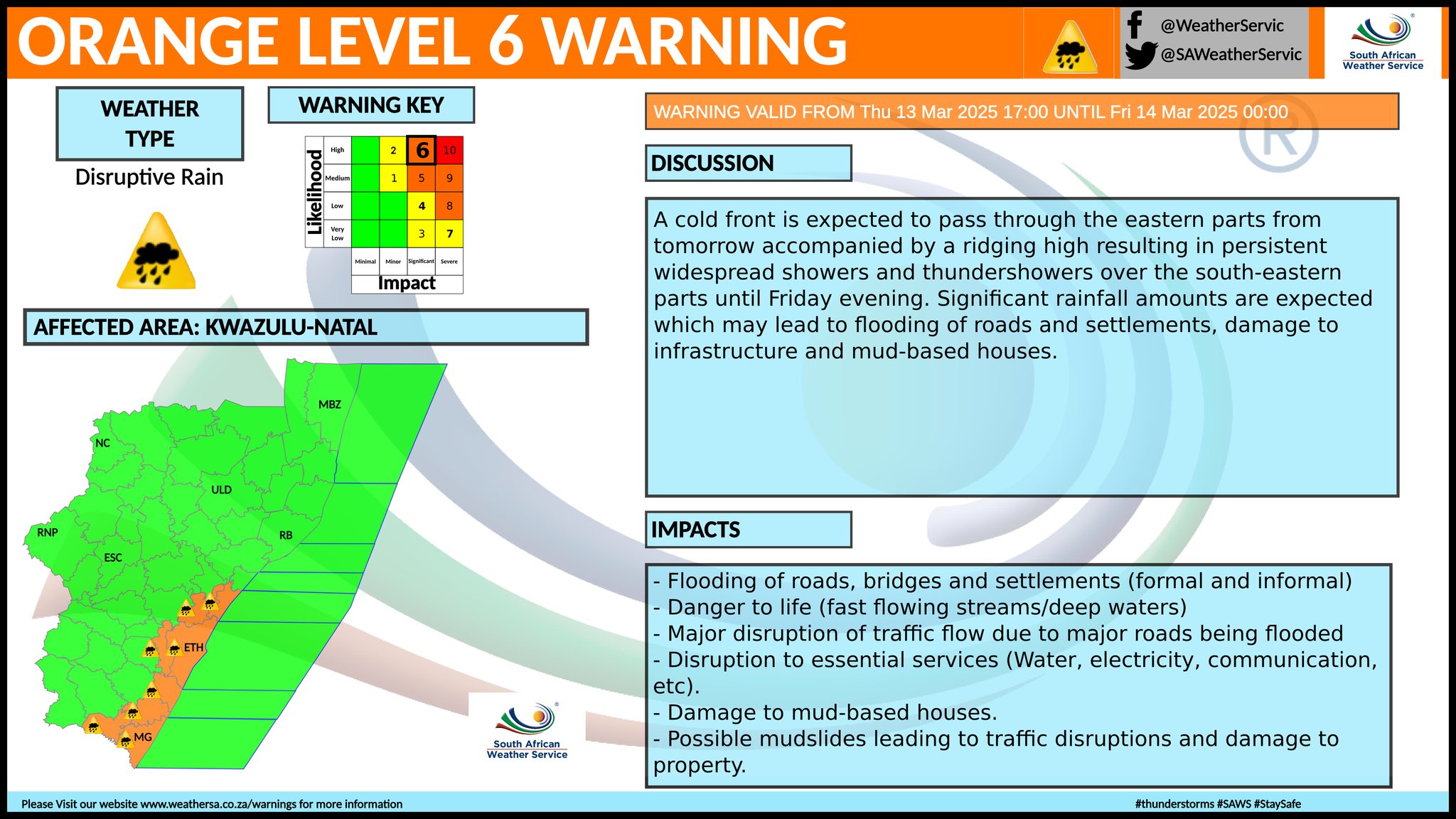
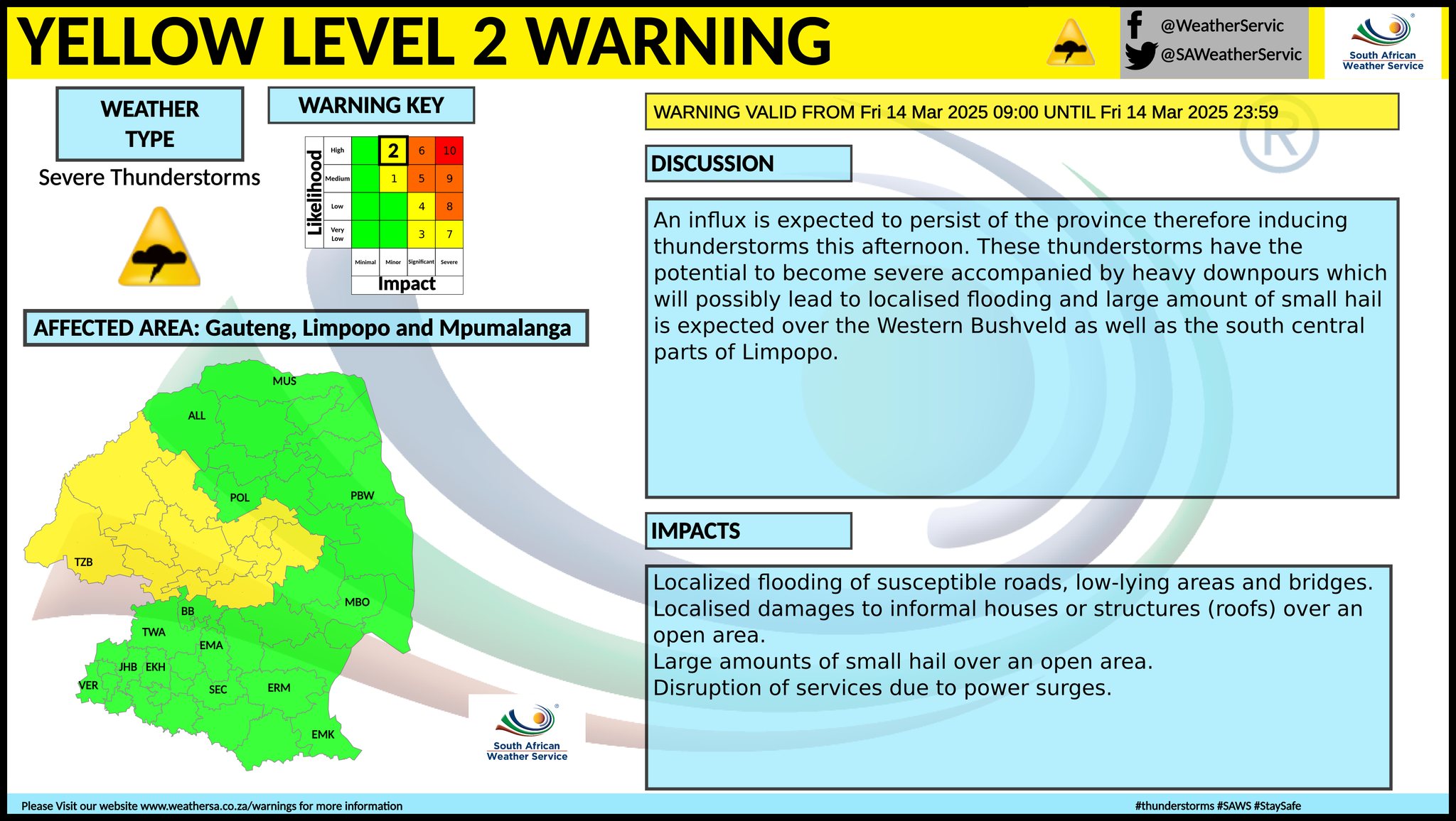
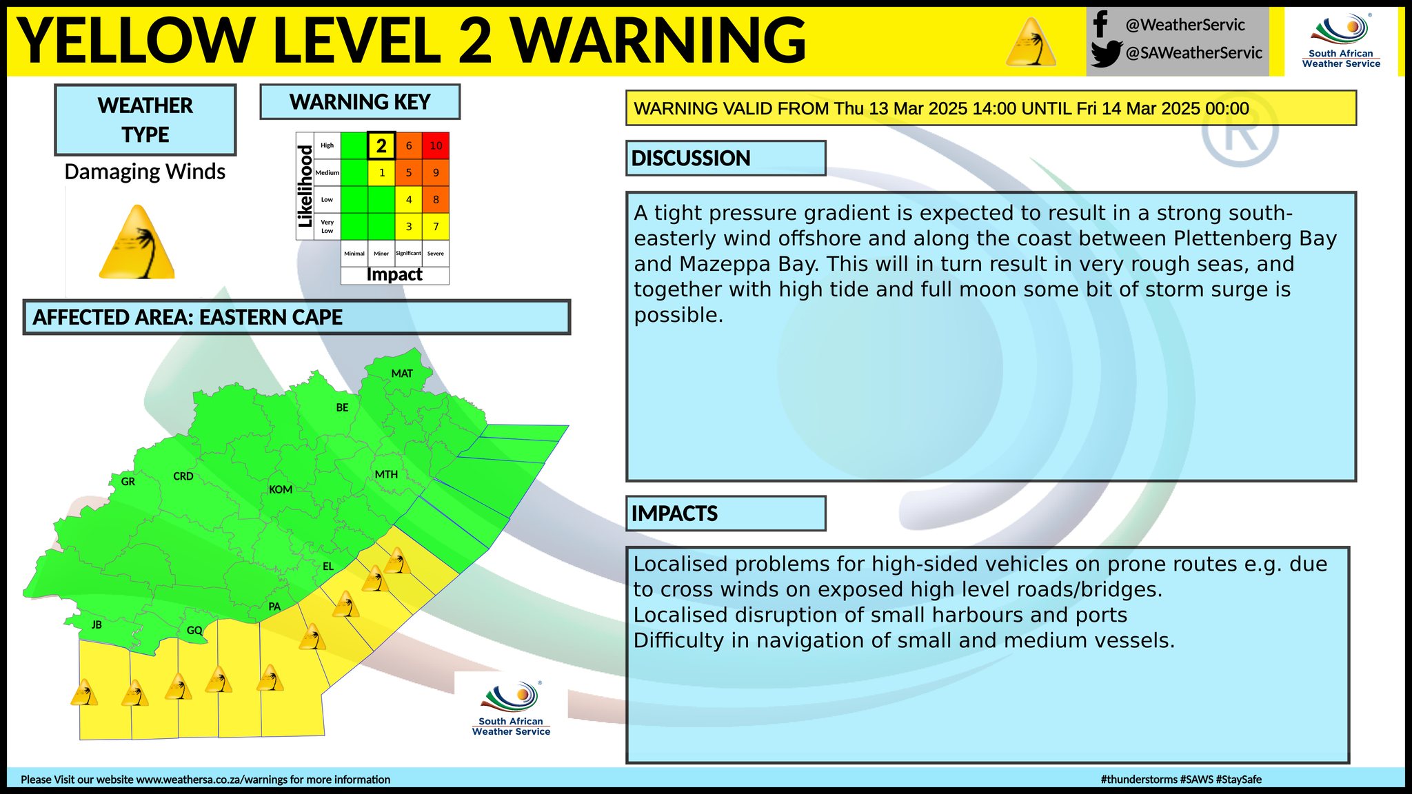
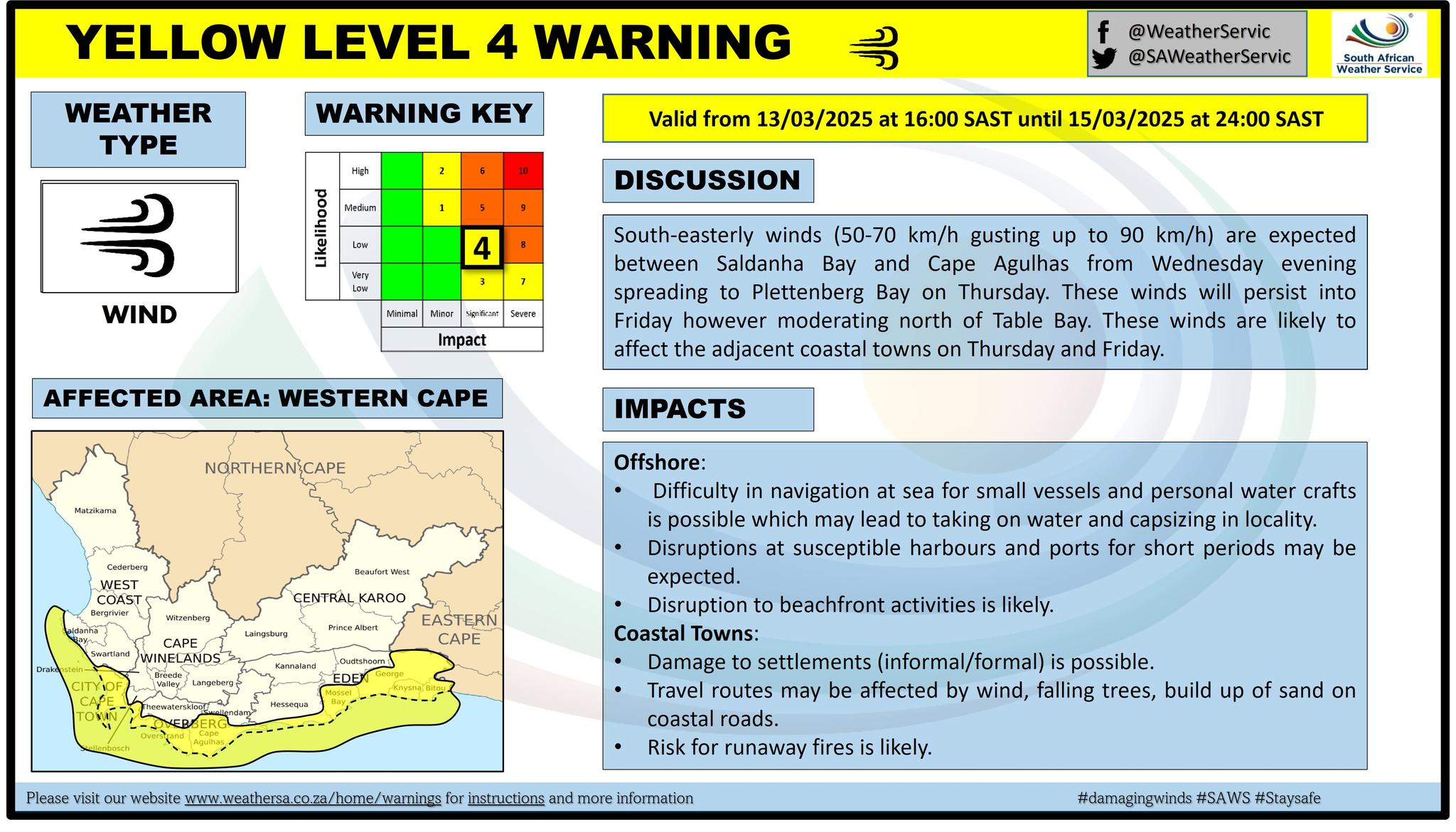
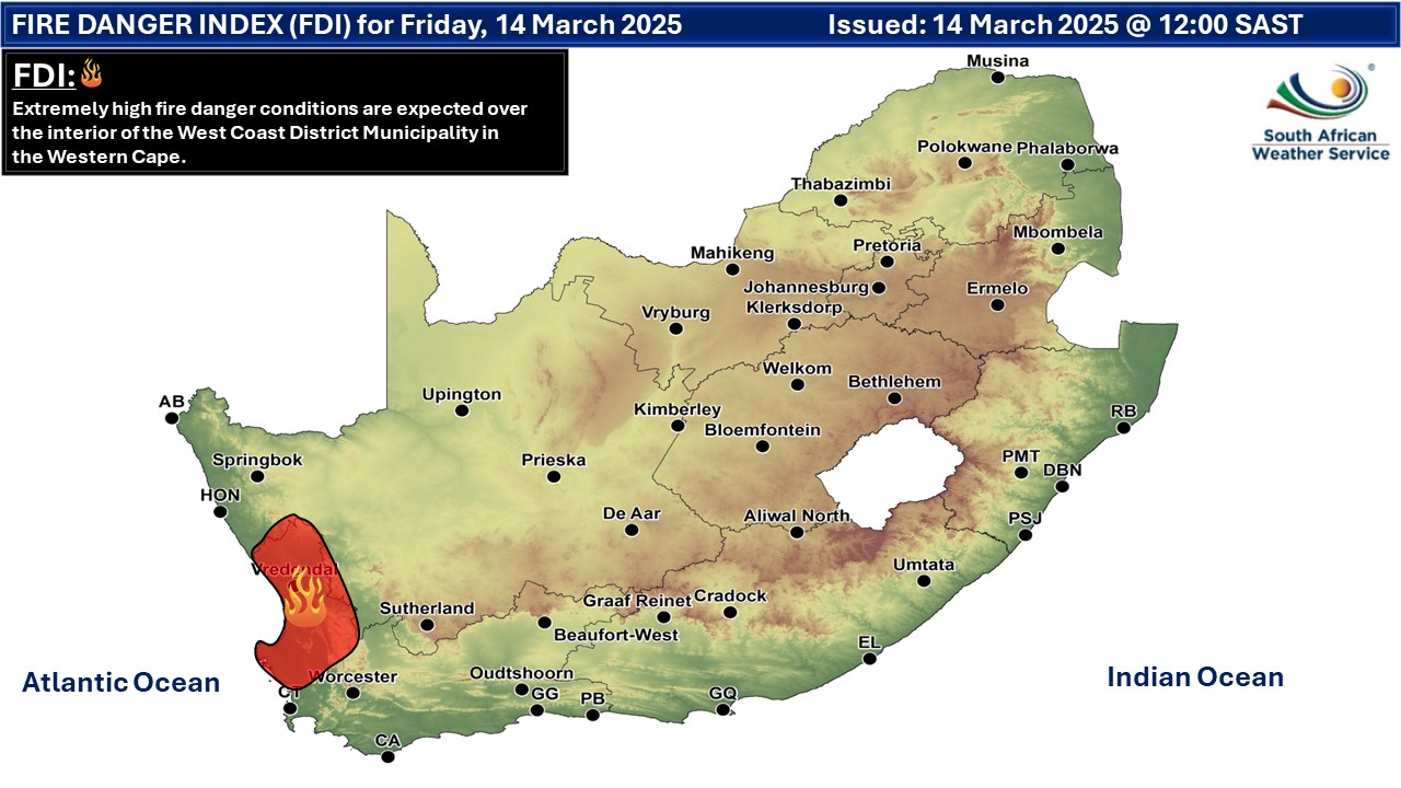
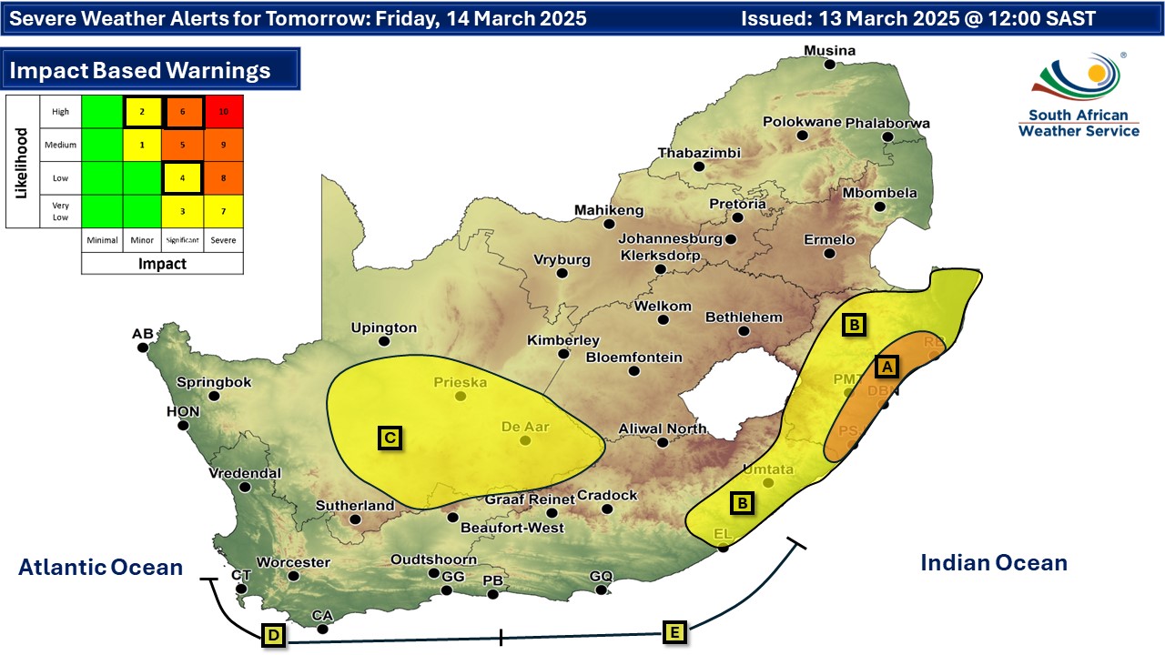
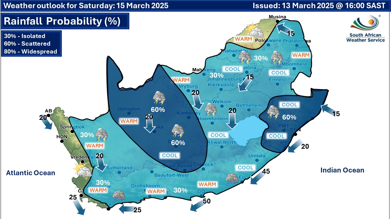
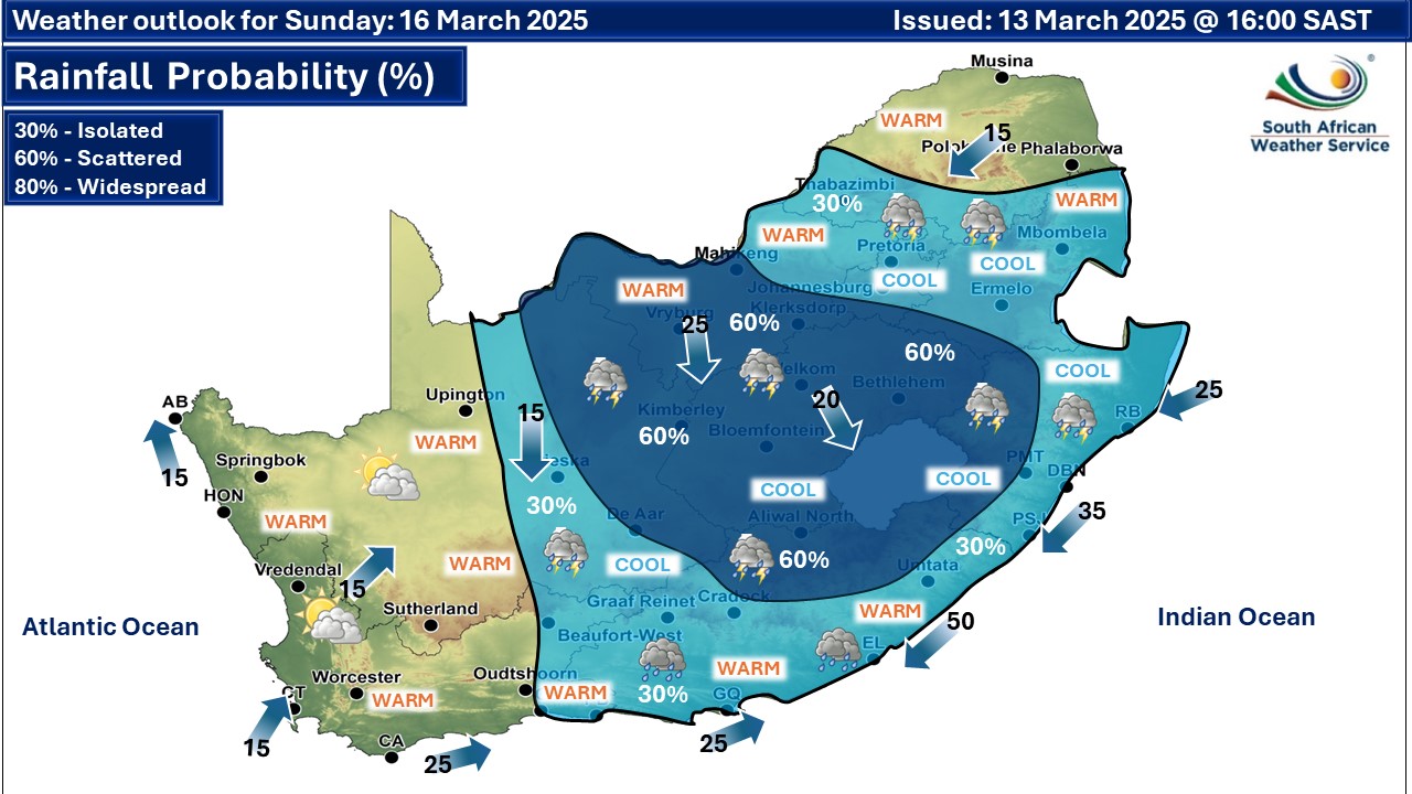
A newer forecast is available by clicking here. A cold front is expected to pass through the eastern parts of South Africa accompanied by a ridging high resulting in persistent widespread showers and thundershowers over the south-eastern parts until Friday evening, bringing with it a significant amount of rainfall according to the SA Weather Service (SAWS). South-easterly winds (50-70 km/h gusting up to 90 km/h) are expected between Saldanha Bay and Cape Agulhas from Wednesday evening spreading to Plettenberg Bay on Thursday. These winds will persist into Friday however moderating north of Table Bay, and are likely to affect the adjacent coastal towns on Thursday and Friday. Southerly to south-easterly swells with wave heights of 4m-5.5m are expected between Saldanha Bay and Cape Agulhas from midday Thursday spreading to Plettenberg Bay during Thursday afternoon. These wave heights will continue throughout Friday, although subsiding north of Table Bay from Friday afternoon. Spring tide is expected for the weekend and thus tides will reaching further up the beachfront. The south-easterly wave direction will allow large waves to impact normally protected bays. From Saturday isolated to scattered showers and thundershowers in most parts of the country, except over the western interior on Sunday. Warnings from the SA Weather Service from Friday: A. orange level 6 warning disruptive rain with heavy downpours leading to flooding of roads and settlements, damage to infrastructure and mudslide along the KwaZulu-Natal coast, except the north coast. B. yellow level 2 warning disruptive rain with heavy downpours leading to localized flooding of roads and settlements, damage to infrastructure and mudslide over most parts of KwaZulu-Natal as well as along the Wild coast and its adjacent interior in the Eastern Cape. C. yellow level 2 warning severe thunderstorms with heavy downpours resulting in localised flooding of susceptible roads and settlements, strong damaging winds, excessive lightning and small hail is possible over the central and south-eastern parts of Northern Cape as well as south-western and southern parts of Limpopo. Parts of North West were also added to this warning on Friday. D. yellow level 4 warning wind and waves leading to difficulty in navigation at sea is expected between Table Bay and Plettenberg Bay. E. yellow level 2 warning wind and waves leading to difficulty in navigation at sea is expected between Plettenberg Bay and Mazeppa Bay. Extremely high fire danger conditions are expected over the interior of the West Coast District Municipality in the Western Cape. Regional forecasts from SAWS for Friday: 1. GAUTENG Partly cloudy and cool to warm with isolated showers and thundershowers. The expected UVB sunburn index: High 2. MPUMALANGA Morning fog along the escarpment, otherwise cloudy and cool to warm with isolated to scattered showers and thundershowers, but partly cloudy in the west. 3. LIMPOPO Morning fog along the escarpment, otherwise partly cloudy and cool to warm with isolated showers and thundershowers. It will be cloudy in the east. 4. NORTH-WEST Partly cloudy and warm with scattered showers and thundershowers, but isolated in the east. 5. FREE STATE Morning fog patches in the east, otherwise partly cloudy and cool to warm with scattered showers and thundershowers, but isolated in the east. 6. NORTHERN CAPE Partly cloudy and warm to hot with isolated to scattered showers and thundershowers except in the west where it will be very hot in places. It will be windy in places in the central and eastern parts. The wind along the coast will be moderate northerly to north-westerly. 7. WESTERN CAPE Cloudy over the southern and eastern parts in the morning with isolated showers and rain along the coast and adjacent interior, otherwise partly cloudy and warm with isolated to scattered thundershowers over the central and eastern interior from the afternoon. It will be fine and hot to very hot in places in the west, but cloudy along the west coast in the evening with fog patches. The wind along the coast will be light to moderate north-westerly along the west coast, otherwise moderate to fresh easterly to south-easterly but strong to near gale in places along the south-west and south coast. The expected UVB sunburn index: Very High 8. WESTERN HALF OF THE EASTERN CAPE Cloudy and cool with isolated showers and thundershowers but scattered in the extreme east as well as along the east coast. The wind along the coast will be fresh to strong easterly, becoming north-easterly in the evening. 9. EASTERN HALF OF THE EASTERN CAPE Cloudy and cold to cool with scattered showers and thundershowers, but widespread along the Wild Coast. The wind along the coast will be fresh to strong easterly, becoming north-easterly in the evening. 10. KWAZULU-NATAL Cloudy and cold to cool with widespread showers and thundershowers but scattered in the north-western parts. It will be warm in the north-east. The wind along the coast will be moderate to fresh southerly to south-easterly reaching strong in places. Travellers forecasts from SAWS for Friday: PRETORIA Partly cloudy with isolated showers and thundershowers. Minimum/Maximum: 17/25°C The expected UVB Sunburn Index: High JOHANNESBURG Partly cloudy with isolated showers and thundershowers. Minimum/Maximum: 15/23°C VEREENIGING Partly cloudy with isolated showers and thundershowers. Minimum/Maximum: 15/23°C MBOMBELA Cloudy with scattered showers and thundershowers. Minimum/Maximum: 18/24°C POLOKWANE Cloudy with isolated showers and thundershowers. Minimum/Maximum: 17/23°C MAHIKENG Partly cloudy with isolated showers and thundershowers. Minimum/Maximum: 16/27°C VRYBURG Partly cloudy with scattered showers and thundershowers. Minimum/Maximum: 16/28°C BLOEMFONTEIN Partly cloudy with scattered showers and thundershowers. Minimum/Maximum: 16/27°C KIMBERLEY Partly cloudy with scattered showers and thundershowers. Minimum/Maximum: 17/27°C UPINGTON Partly cloudy with isolated showers and thundershowers. Minimum/Maximum: 22/31°C CAPE TOWN Fine. Wind: Light to moderate south-easterly. Minimum/Maximum: 21/34°C The expected UVB Sunburn Index: Very High GEORGE Cloudy with light morning rain, becoming partly cloudy from the afternoon. Wind: Moderate to fresh easterly to south-easterly. Minimum/Maximum: 18/22°C GQEBERHA Cloudy with scattered showers and rain. Wind: Fresh to strong easterly, becoming north-easterly in the evening. Minimum/Maximum: 17/20°C EAST LONDON Cloudy with scattered showers and thundershowers. Wind: Fresh to strong easterly, becoming north-easterly in the evening. Minimum/Maximum: 18/20°C DURBAN Cloudy with widespread showers and thundershowers. Wind: Moderate to fresh southerly to south-easterly. Minimum/Maximum: 21/24°C The expected UVB Sunburn Index: Moderate RICHARDS BAY Cloudy with widespread showers and thundershowers. Wind: Moderate to fresh southerly to south-easterly. Minimum/Maximum: 22/25°C PIETERMARITZBURG Cloudy with widespread showers and thundershowers. Minimum/Maximum: 15/22°C This forecast is usually updated a few times per day.
Please be sure to send photos and videos to us via whatsapp and also tell us where and when they were taken. Follow our channels
Previous Maps for Friday 14 March
 Maps for Saturday 15 March
   Maps for Sunday 16 March
|