
 More maps below the forecast
A good chance of thunderstorms in the east on Wednesday12 November 2024 [updated 13 November]By Staff Writer
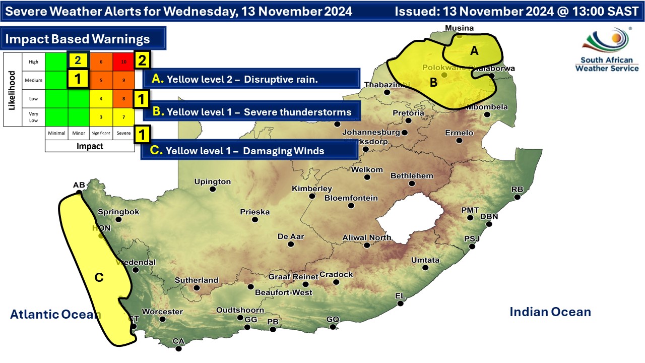
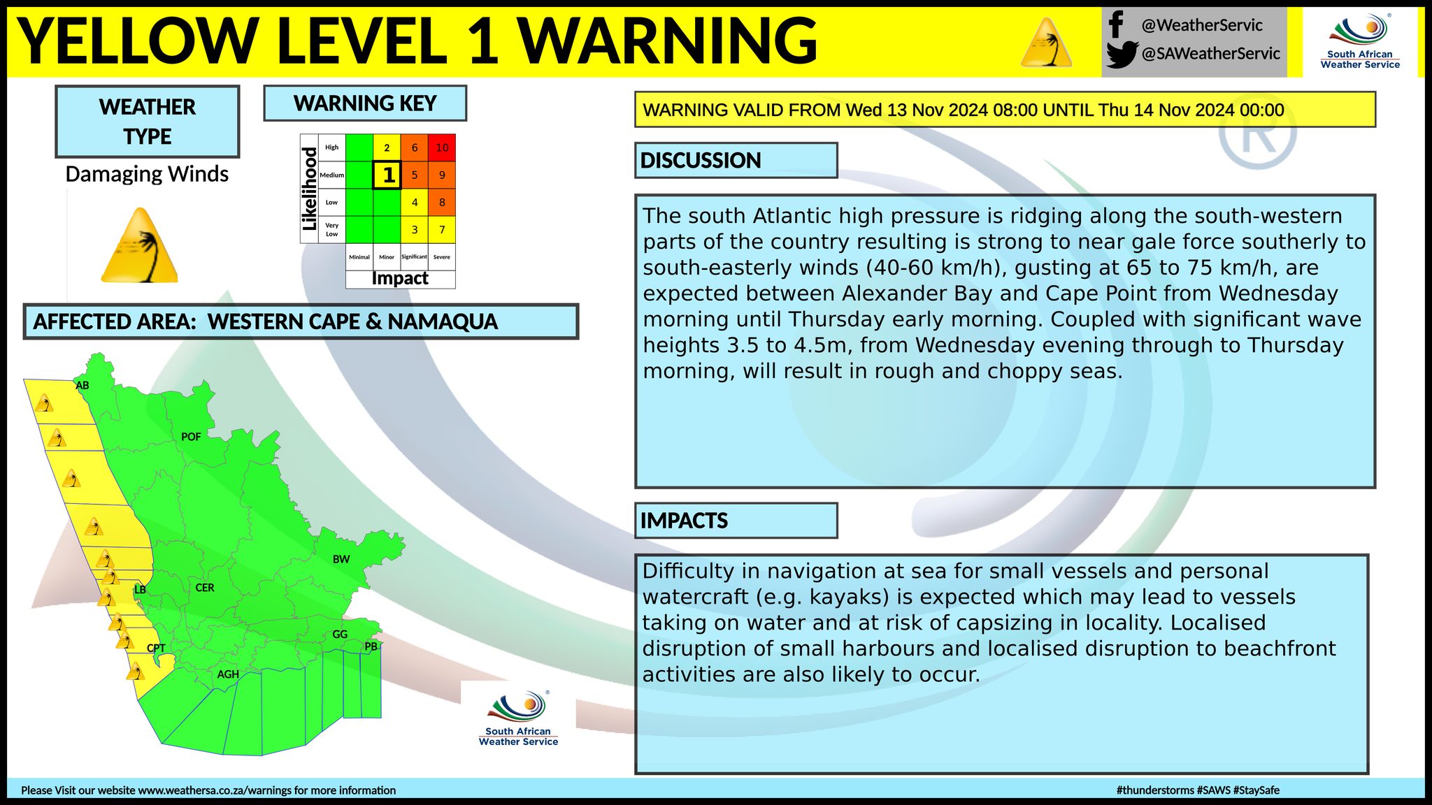
Warnings from the SA Weather Service (SAWS) for Wednesday: A. yellow level 2 warning for disruptive rain resulting in localised flooding of susceptible roads and bridges, settlements and low-lying areas due to heavy downpours is expected over the extreme north-eastern parts of Limpopo. B. yellow level 1 warning for severe thunderstorms resulting in flooding of roads, damage to property and infrastructure due to strong winds and hail are expected over the central parts of Limpopo. C. yellow level 1 warning for damaging winds resulting in difficulty in navigation at sea for small vessels and personal watercraft (e.g. kayaks) is expected which may lead to vessels taking on water and at risk of capsizing in locality. Localised disruption of small harbours and localised disruption to beachfront activities are also likely to occur between Alexander Bay and Cape Point. Extreme Fire danger condition are expected in places over the Dawid Kruiper, Kai !Garib and Kamiesberg Municipalities in the Northern Cape as well as Matzikama Municipality in the Western Cape. Regional forecasts from SAWS for Wednesday: 1. GAUTENG Morning fog in places, otherwise partly cloudy and warm with isolated showers and thundershowers. The expected UVB sunburn index: High 2. MPUMALANGA Morning fog in places over the highveld, othersier otherwise partly cloudy and cool with isolated showers and thundershowers but scattered along the escarpment where it will be cloudy. It will be warm in the Lowveld. 3. LIMPOPO Morning fog in places over the central and western areas, otherwise partly cloudy and cool to warm with isolated showers and thundershowers but scattered in the east. 4. NORTH-WEST PROVINCE Morning fog in places at first, otherwise partly cloudy and warm with isolated to scattered showers and thundershowers, but fine over the extreme north-western parts. 5. FREE STATE Morning fog in places, otherwise partly cloudy and warm to hot with isolated showers and thundershowers over the central and the eastern parts. 6.NORTHERN CAPE Fine and warm to hot, becoming partly cloudy over the eastern parts. It will be cool in the west. The wind along the coast will be Fresh to strong southerly to south-easterly. 7. WESTERN CAPE Fine and warm to hot along the west coast otherwise cloudy and cool with light rain along the south coast in the morning becoming partly cloudy from the afternoon. The wind along the coast will be moderate to fresh southerly but strong to gale along the west coast from the afternoon. The expected UVB sunburn index: Very High 8. WESTERN HALF OF THE EASTERN CAPE Warm in the north, otherwise cloudy and cool with isolated showers in the south. The wind along the coast will be Moderate to fresh westerly, becoming southerly from midday. 9. EASTERN HALF OF THE EASTERN CAPE Cloudy and cool with isolated showers and rain south of the escarpment, but scattered along the wild coast. Isolated thundershowers are expected along the escarpment. The wind along the coast will be Light to moderate south-westerly, becoming southerly by evening. 10. KWAZULU-NATAL Morning fog in places over the interior, otherwise partly cloudy and cool to warm. It will become cloudy in the afternoon with isolated showers and thundershowers but scattered in the south. The wind along the coast will be moderate to fresh southerly to south-westerly, becoming strong to near-gale from the south. The expected UVB sunburn index: High Travellers forecasts from SAWS for Wednesday: PRETORIA Morning fog, otherwise partly cloudy with isolated showers and thundershowers. Minimum/Maximum: 16/28°C The expected UVB Sunburn Index: High JOHANNESBURG Morning fog, otherwise partly cloudy with isolated showers and thundershowers. Minimum/Maximum: 14/27°C VEREENIGING Morning fog, otherwise partly cloudy with isolated showers and thundershowers. Minimum/Maximum: 14/28°C MBOMBELA Cloudy with isolated to scattered showers and thundershowers. Minimum/Maximum: 18/26°C POLOKWANE Cloudy with scattered showers and thundershowers. Minimum/Maximum: 16/24°C MAHIKENG Partly cloudy, with scattered showers and thundershowers. Minimum/Maximum: 15/30°C VRYBURG Partly cloudy. Minimum/Maximum: 15/32°C BLOEMFONTEIN Morning fog, otherwise partly cloudy with isolated showers and thundershowers. Minimum/Maximum: 13/29°C KIMBERLEY Fine, becoming partly cloudy in the afternoon. Minimum/Maximum: 17/31°C UPINGTON Fine. Minimum/Maximum: 19/34°C CAPE TOWN Partly cloudy in the morning becoming fine. Wind: Fresh to strong south-easterly Minimum/Maximum: 15/22°C The expected UVB Sunburn Index: Very High GEORGE Cloudy with light rain in the morning. Wind: Moderate south-easterly. Minimum/Maximum: 13/20°C GQEBERHA Cloudy with isolated showers. Wind: Moderate to fresh westerly, becoming southerly from midday. Minimum/Maximum: 14/20°C EAST LONDON Partly cloudy becoming cloudy with isolated showers by afternoon. Wind: Light to moderate south-westerly, becoming southerly from late afternoon. Minimum/Maximum: 16/23°C DURBAN Partly cloudy, becoming cloudy with scattered showers and thundershowers. Wind: Fresh to strong southerly to south-westerly, becoming near gale at times. Minimum/Maximum: 18/24°C The expected UVB Sunburn Index: High RICHARDS BAY Partly cloudy with isolated showers and thundershowers. Wind: Fresh to strong southerly to south-westerly, becoming near gale at times. Minimum/Maximum: 19/25°C PIETERMARITZBURG Morning fog patches, otherwise partly cloudy, becoming cloudy with scattered showers and thundershowers. Minimum/Maximum: 13/22°C This forecast may change and updates issued more than once a day. Please be sure to send photos and videos to us via whatsapp and also tell us where and when they were taken. See below for a link to our whatsapp channel but since the link does not work in the instagram app you will need to send us a whatsapp message and we'll send you a link. Follow our channels
Standard users are welcome to use the standard sharing buttons on this page to share our content. It is NOT acceptable to download or screen grab for reposting. Other media and channels need to send us a request in order to embed or use of our forecasts, maps, as well as images and video from our users that we post (before doing so).
Issued on Wednesday
    Issued on Tuesday
 |