
WEDNESDAY WEATHER: Cold and wet in places with wind, wave and storm surge warnings
By Staff WriterPublished: 12 May 2026
This forecast is for: Wed 13 May 2026
The maps cover: Wed 13 May – Wed 13 May
| SHARE TO |
The latest forecast is available by clicking here.
Very cold, wet and windy conditions are expected over the southern parts of Namakwa District in the Northern Cape and interior of the Western Cape on Wednesday.
Warnings from the SA Weather Service from Wednesday:
A. level 4 warning for damaging winds and waves leading to danger to navigation at sea is expected along the coast between Cape Point to Plettenberg Bay.
B. level 2 warning for storm surge leading to localised flooding of low-lying coastal areas is expected between Saldanha Bay and west of Cape Agulhas.
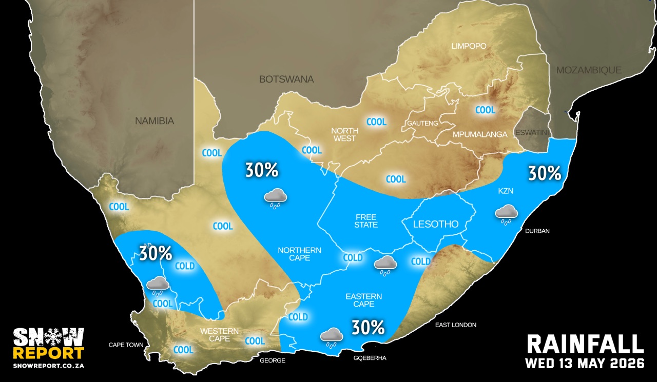
Regional forecasts from the SA Weather Service for Wednesday:
GAUTENG
Fine and cool to warm.
MPUMALANGA
Fine and cool to warm but hot in places in the Lowveld.
LIMPOPO
Fine and warm, but hot in places in the Lowveld.
NORTH-WEST
Fine and cool.
THE FREE STATE
Fine and cold to cool, but partly cloudy and windy in the west with isolated showers and thundershowers.
THE NORTHERN CAPE
Cloudy to partly cloudy and cold to cool with isolated showers and rain over the eastern parts, and the extreme south-western parts.
THE WESTERN CAPE
Cloudy and cool to cold with isolated showers and rain in the extreme north-western parts. The wind along the coast will be moderate to fresh south-westerly but fresh to strong westerly along the south coast.
THE WESTERN HALF OF THE EASTERN CAPE
Cloudy and cool to cold, with isolated showers and rain mainly in the morning. The wind along the coast will be fresh to strong south-westerly, reaching near-gale at times.
THE EASTERN HALF OF THE EASTERN CAPE
Cloudy to partly cloudy and cool to warm, but cold with light rain at times in the north. The wind along the coast will be fresh to strong south-westerly.
KWAZULU-NATAL
Partly cloudy and cool to warm with isolated showers and rain except in the extreme north-west. The wind along the coast will be light to moderate westerly to south-westerly, becoming moderate to fresh southerly to south-easterly from the afternoon.
Travellers forecasts from the SA Weather Service for Wednesday:
PRETORIA
Fine.
Minimum/Maximum: 8/25°C
JOHANNESBURG
Fine.
Minimum/Maximum: 6/22°C
VEREENIGING
Fine.
Minimum/Maximum: 5/20°C
MBOMBELA
Fine.
Minimum/Maximum: 16/30°C
POLOKWANE
Fine.
Minimum/Maximum: 10/26°C
MAHIKENG
Fine.
Minimum/Maximum: 7/23°C
VRYBURG
Fine.
Minimum/Maximum: 7/23°C
BLOEMFONTEIN
Partly cloudy and windy with isolated showers and thundershowers.
Minimum/Maximum: 7/16°C
KIMBERLEY
Partly cloudy and windy with isolated showers and thundershowers.
Minimum/Maximum: 7/23°C
UPINGTON
Partly cloudy with isolated showers and
thundershowers.
Minimum/Maximum: 8/20°C
CAPE TOWN
Cloudy, becoming partly cloudy.
Wind: Light to moderate south-westerly.
Minimum/Maximum: 14/17°C
GEORGE
Cloudy, becoming partly cloudy.
Wind: Strong south-westerly.
Minimum/Maximum: 14/17°C
GQEBERHA
Cloudy and windy with showers and rain.
Wind: Fresh to strong south-westerly, reaching near-gale at times.
Minimum/Maximum: 15/19°C
EAST LONDON
Cloudy, becoming partly cloudy.
Wind: Fresh to strong south-westerly.
Minimum/Maximum: 16/22°C
DURBAN
Partly cloudy with isolated evening showers and rain.
Wind: Light north-westerly, becoming light to moderate southerly to south-easterly from the
afternoon.
Minimum/Maximum: 19/28°C
RICHARDS BAY
Partly cloudy, becoming cloudy from the evening with isolated showers and rain.
Wind: Light north-westerly, becoming light to moderate southerly to south-easterly from the afternoon.
Minimum/Maximum: 17/29°C
PIETERMARITZBURG
Partly cloudy, becoming cloudy from the evening with isolated showers and rain.
Minimum/Maximum: 10/28°C
This forecast is usually updated a few times per day.
| SHARE TO |
Please be sure to send photos and videos to us via whatsapp and also tell us where and when they were taken.
Follow our channels