
   Swipe left or right for more maps, and see below for others
The disruptive snow and rain are gone on Wednesday but there are warnings for wind and wavesBy Staff WriterPublished: 10 June 2025 [updated 11 June] This forecast is for: Wed 11 June 2025 The maps cover: Wed 11 Jun – Fri 13 Jun
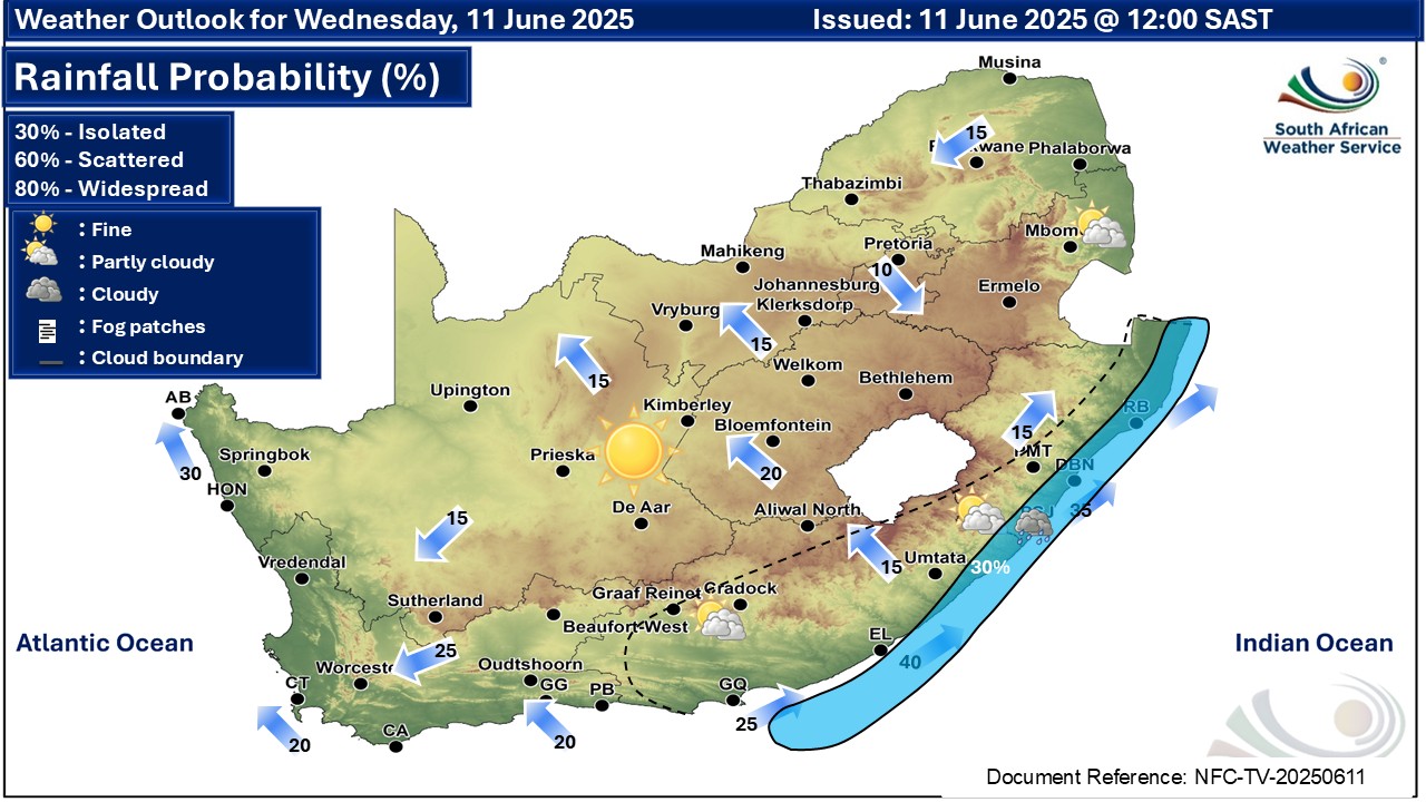
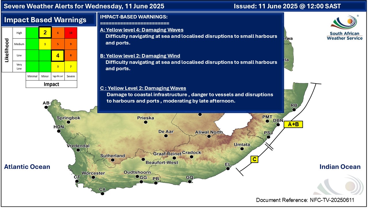
A newer forecast is available by clicking here. Isolated showers are expected along the east coast of the Eastern Cape, according to the SA Weather Service. Warnings from the SA Weather for Wednesday: A. level 4 warning for damaging waves along the coast of KwaZulu-Natal, as per the map. B. level 2 warning for damaging winds along the coast of KwaZulu-Natal, as per the map. C. level 2 warning for damaging waves between East London and Port Edward, as per the map. Regional forecasts from SAWS for Wednesday: 1. GAUTENG Frost in places in the morning, otherwise fine and cold. It will be foggy in the south and central parts. The expected UVB sunburn index: High 2. MPUMALANGA Morning fog patches in the south, otherwise fine and cold to cool, but partly cloudy in the east. 3. LIMPOPO Fine and cool. 4. NORTH-WEST PROVINCE Fine and cold. 5. FREE STATE Fine and cold. 6. NORTHERN CAPE Fine and cold to cool. The wind along the coast will be moderate south-easterly. 7. WESTERN CAPE Partly cloudy over the eastern parts in the morning, otherwise fine and cool to cold. Frost is possible over the central interior in the morning. The wind along the coast will be light to moderate easterly to south-easterly. The expected UVB sunburn index: Moderate 8. WESTERN HALF OF THE EASTERN CAPE Cloudy with chances of light rain along the coast in the morning, otherwise partly cloudy and cold to cool. The wind along the coast will be moderate to fresh westerly, becoming light south-westerly from the west in the afternoon. 9. EASTERN HALF OF THE EASTERN CAPE Cloudy, becoming partly cloudy and cold to very cold with chances of light rain along the coast, clearing from the west. The wind along the coast will be fresh to strong westerly, moderating in the evening. 10. KWAZULU-NATAL Partly cloudy and cold to cool. It will be very cold in the extreme south-west. The wind along the coast will be moderate to fresh westerly to south-westerly, reaching strong. Travellers forecasts from SAWS for Wednesday: PRETORIA Fine. Minimum/Maximum: 4/14°C The expected UVB Sunburn Index: High JOHANNESBURG Fine. Minimum/Maximum: 3/11°C VEREENIGING Fine. Minimum/Maximum: 1/11°C MBOMBELA Fine, becoming partly cloudy by the afternoon. Minimum/Maximum: 7/22°C POLOKWANE Fine. Minimum/Maximum: 5/19°C MAHIKENG Fine Minimum/Maximum: 1/16°C VRYBURG Fine Minimum/Maximum: 0/15°C BLOEMFONTEIN Fine. Minimum/Maximum: 1/14°C KIMBERLEY Fine Minimum/Maximum: 1/14°C UPINGTON Fine Minimum/Maximum: 1/16°C CAPE TOWN Fine. Wind: Light and variable in the morning, otherwise light south-easterly. Minimum/Maximum: 11/17°C The expected UVB Sunburn Index: Moderate GEORGE Partly cloudy in the morning, otherwise fine. Wind: Light and variable in the morning, otherwise light to moderate easterly to south-easterly. Minimum/Maximum: 9/17°C GQEBERHA Cloudy with chance of early morning rain, otherwise partly cloudy Wind: Light to moderate westerly, becoming light south-westerly in the afternoon. Minimum/Maximum: 12/18°C EAST LONDON Cloudy with chance of morning rain, otherwise partly cloudy. Wind: Moderate to fresh south-westerly, becoming light westerly in the evening. Minimum/Maximum: 13/18°C DURBAN Partly cloudy. Wind: Moderate to fresh westerly to south-westerly. Minimum/Maximum: 15/19°C The expected UVB Sunburn Index: Moderate RICHARDS BAY Partly cloudy. Wind: Fresh to strong south-westerly. Minimum/Maximum: 15/20°C PIETERMARITZBURG Partly cloudy. Minimum/Maximum: 6/15°C This forecast is usually updated a few times per day.
Please be sure to send photos and videos to us via whatsapp and also tell us where and when they were taken. Follow our channels
Maps for Thursday 12 June
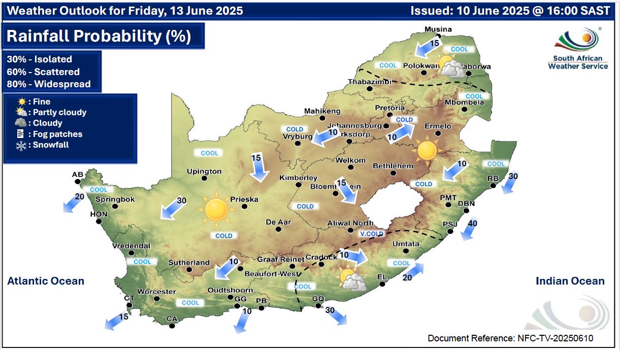
 Maps for Friday 13 June
|