
      Swipe left or right for more maps, and see below for others
Five weather warnings for damaging winds and damaging waves on SaturdayBy Staff WriterPublished: 9 May 2025 [updated 10 May] This forecast is for: Sat 10 May 2025 The maps cover: Sat 10 May – Mon 12 May
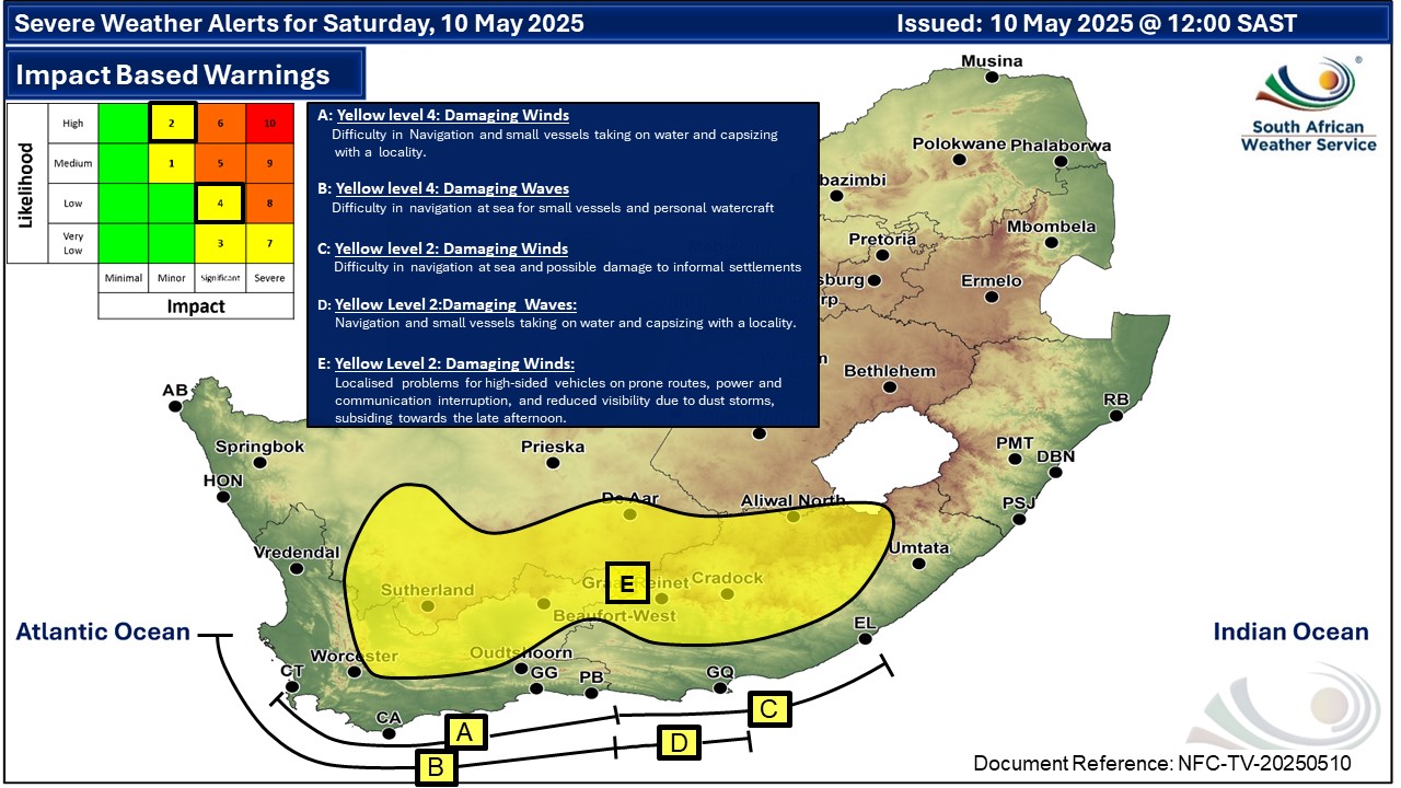
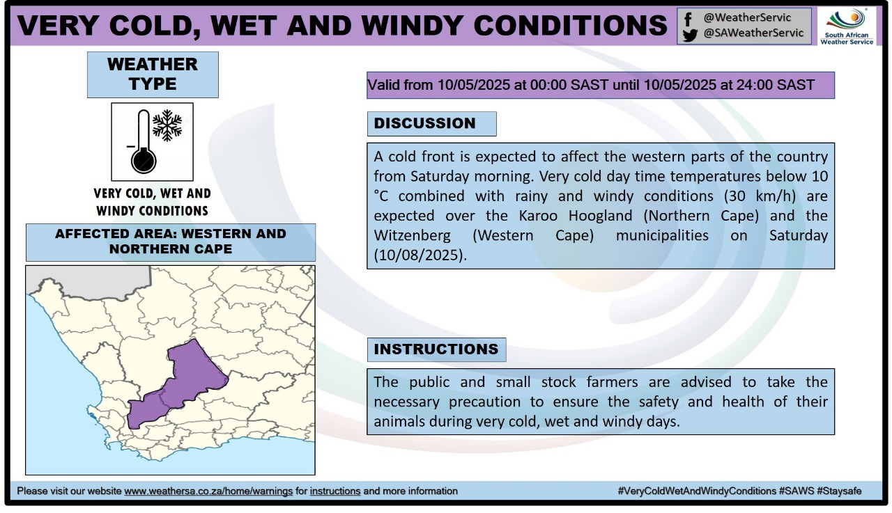
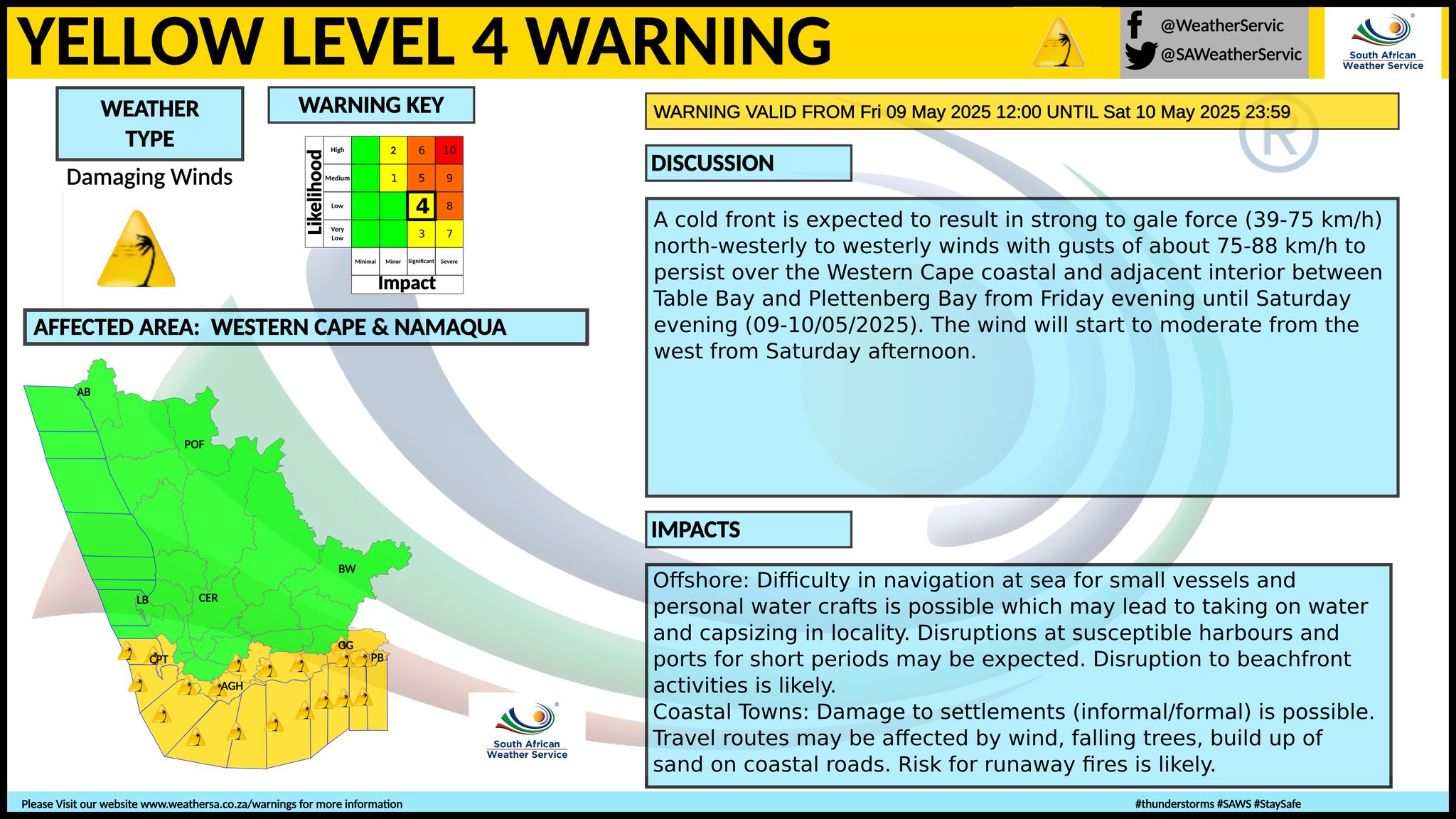
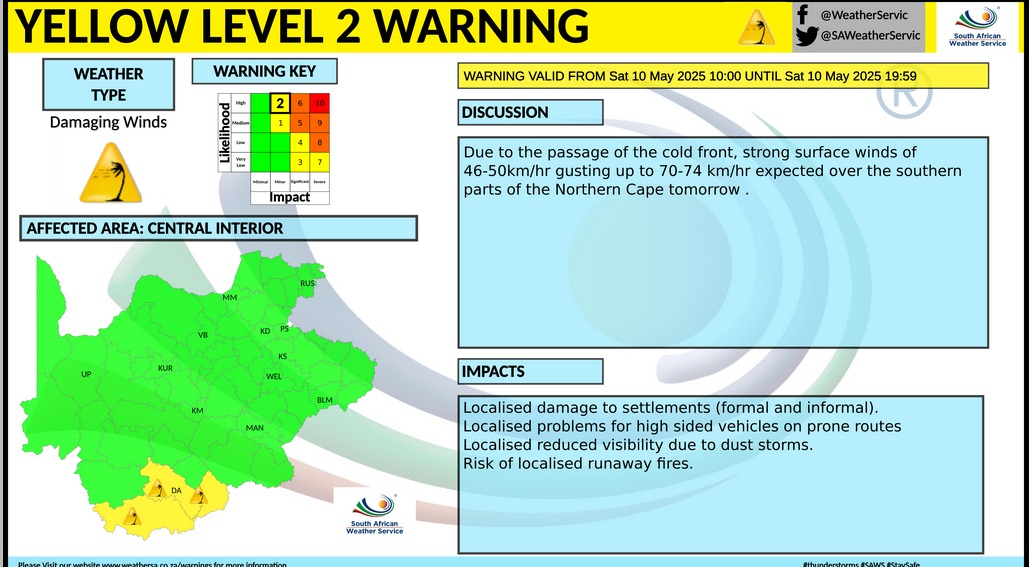
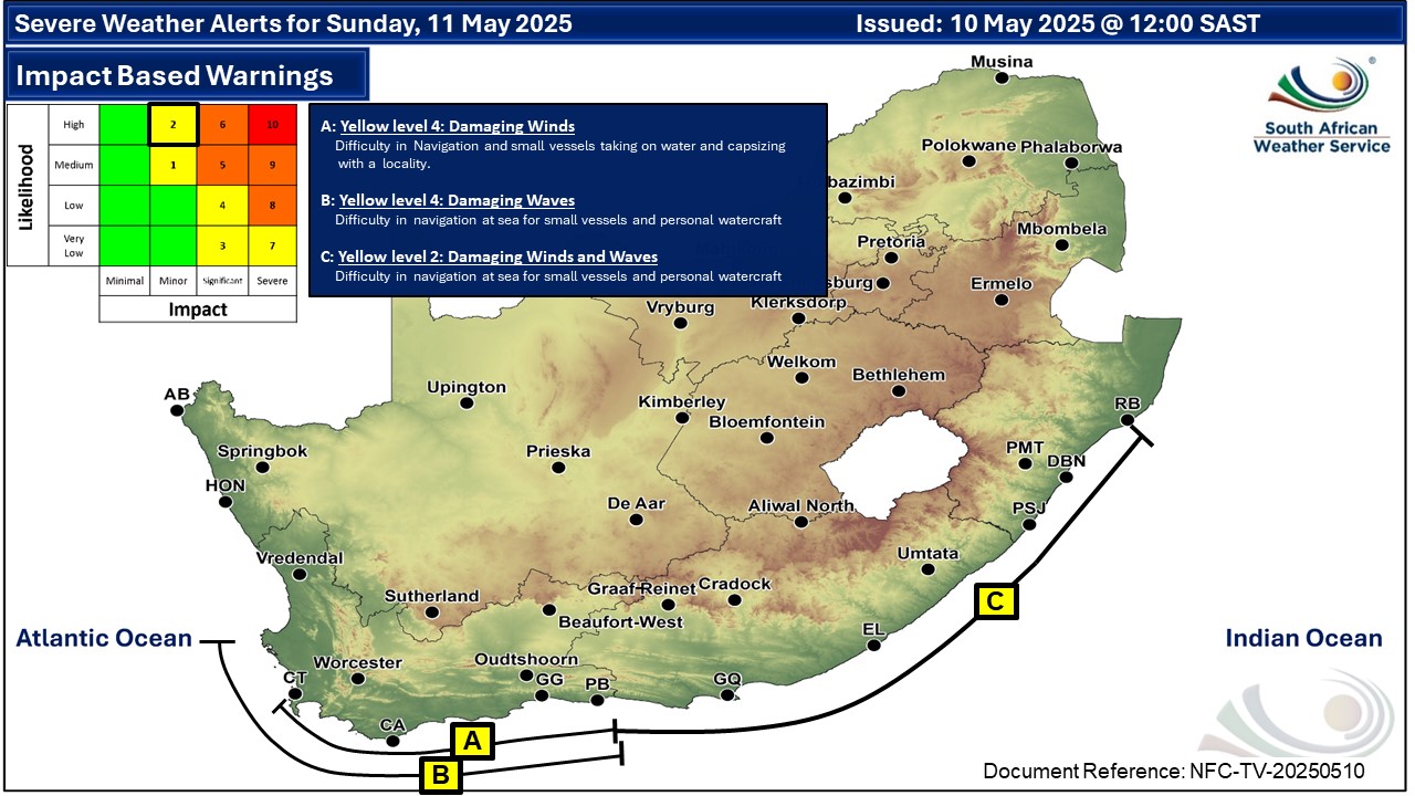
A newer forecast is available by clicking here. A cold front is expected to affect the western parts of South Africa from Saturday morning. Very cold, wet and windy conditions are expected over the Karoo Hoogland local municipality in the Northern Cape and the Witzenberg local municipality in the Western Cape, according to the SA Weather Service (SAWS). Strong to gale force north-westerly winds are expected in places over Chris Hani and Joe Gqabi district municipalities in the Eastern Cape, while westerly to south-westerly winds accompanied with very rough seas are expected in places along the coast between Plettenberg Bay and Peddie until Sunday. SEE ALSO: Light snowfall possible in the Western Cape this weekend. Warnings from the SAWS for Saturday: A. level 4 warning for damaging winds leading to difficulty in navigation at sea and possible damage to informal settlements are expected between Saldanna Bay and Plettenberg Bay. B. level 4 warning for damaging waves leading to difficulty in navigation at sea for small vessels and personal watercraft is expected between Table Bay and Plettenberg Bay. C. level 2 warning for damaging winds leading to difficulty in navigation at sea and possible damage to informal settlements are expected along the coast between Plettenberg Bay and East London. D. level 2 warning for damaging waves resulting in difficulty in navigation and small vessels taking on water and capsizing within a locality are expected along the coast between Plettenberg Bay and Port Elizabeth from the evening, spreading to Port Edward. E. level 2 warning for damaging winds leading to localised problems for high-sided vehicles on prone routes is expected over the southern part of the Northern Cape, the central and the eastern part of the Western Cape, as well as the central and the northern part of the Eastern Cape. Extreme high fire danger conditions are expected over Beaufort West and Hessequa local municipalities in the Western Cape, as well as north-western part of the Eastern Cape. Regional forecasts from SAWS for Saturday: 1. GAUTENG Fine and cool but warm in the north. The expected UVB sunburn index: Very High 2. MPUMALANGA Fine and cool to warm to hot in places in the Lowveld. 3. LIMPOPO Fine and cool to warm. 4. NORTH-WEST Fine and cool to warm. 5. FREE STATE Fine and cool to warm. 6. NORTHERN CAPE Cloudy in the west, otherwise fine, windy and cool to warm, with isolated showers and thundershowers over the southern parts and along the escarpment from later the morning. It will be cold to very cold over the extreme southern parts. Wind along the coast will be moderate to fresh north to north-westerly, but strong south of Hondeklip Baai. It will become light to moderate west to south-westerly during the afternoon, while light and variable by the evening. 7. WESTERN CAPE Cloudy, windy and cold with isolated to scattered showers and rain except in the north-east where it will be partly cloudy and cool. Light rain expected along the south coast from late afternoon. The wind along the coast will be fresh to strong west to north-westerly, reaching near-gale along the western parts until the evening, while spreading along the south coast from late afternoon. It will become south-westerly over the west from late afternoon. The expected UVB sunburn index: Low 8. WESTERN HALF OF THE EASTERN CAPE Partly cloudy and cool in places, otherwise fine, windy and warm with isolated showers and rain along the coast and adjacent interior west of Gqeberha from the evening. The wind along the coast will be light north-westerly in places in the morning, otherwise moderate to fresh south-westerly, becoming strong from the afternoon. 9. EASTERN HALF OF THE EASTERN CAPE Morning fog in places along the coast south of Kei Mouth, otherwise fine, windy and warm, but cool north of the escarpment. It will become partly cloudy from the afternoon. The wind along the coast will be light to moderate north-westerly, but moderate to fresh south-westerly in the south, spreading to Port Edward in the evening. 10. KWAZULU-NATAL Fine and warm, but cool in the south-west. The wind along the coast will be light north-westerly south of Durban in the morning, otherwise moderate to fresh northerly to north-easterly, but strong north of Richards Bay. The expected UVB sunburn index: Extreme Travellers forecasts from SAWS for Saturday: PRETORIA Fine. Minimum/Maximum: 10/25°C The expected UVB Sunburn Index: Very High JOHANNESBURG Fine. Minimum/Maximum: 6/23°C VEREENIGING Fine. Minimum/Maximum: 7/24°C MBOMBELA Fine. Minimum/Maximum: 12/26°C POLOKWANE Fine. Minimum/Maximum: 9/25°C MAHIKENG Fine. Minimum/Maximum: 10/25°C VRYBURG Fine. Minimum/Maximum: 7/26°C BLOEMFONTEIN Fine. Minimum/Maximum: 6/24°C KIMBERLEY Fine. Minimum/Maximum: 9/26°C UPINGTON Fine and windy. Minimum/Maximum: 10/26°C CAPE TOWN Cloudy and windy with scattered showers and rain. Wind: Strong to near-gale force west to north-westerly, moderating from late afternoon. Minimum/Maximum: 14/19°C The expected UVB Sunburn Index: Low GEORGE Fine becoming partly cloudy with light rain from the evening. Wind: Fresh to strong west to north-westerly. Minimum/Maximum: 13/23°C GQEBERHA Fine becoming partly cloudy, but cloudy from the evening. Wind: Light north-westerly in the morning, otherwise moderate to fresh south-westerly, becoming strong in the evening. Minimum/Maximum: 13/24°C EAST LONDON Partly cloudy, becoming fine in the afternoon. Wind: Light to moderate south-westerly, reaching fresh in the afternoon. Minimum/Maximum: 17/26°C DURBAN Fine. Wind: Light to moderate northerly to north-westerly, becoming north-easterly from late morning. Minimum/Maximum: 19/30°C The expected UVB Sunburn Index: Extreme RICHARDS BAY Fine. Wind: Fresh to strong northerly to north-easterly. Minimum/Maximum: 18/32°C PIETERMARITZBURG Fine. Minimum/Maximum: 11/29°C This forecast is usually updated a few times per day.
Please be sure to send photos and videos to us via whatsapp and also tell us where and when they were taken. Follow our channels
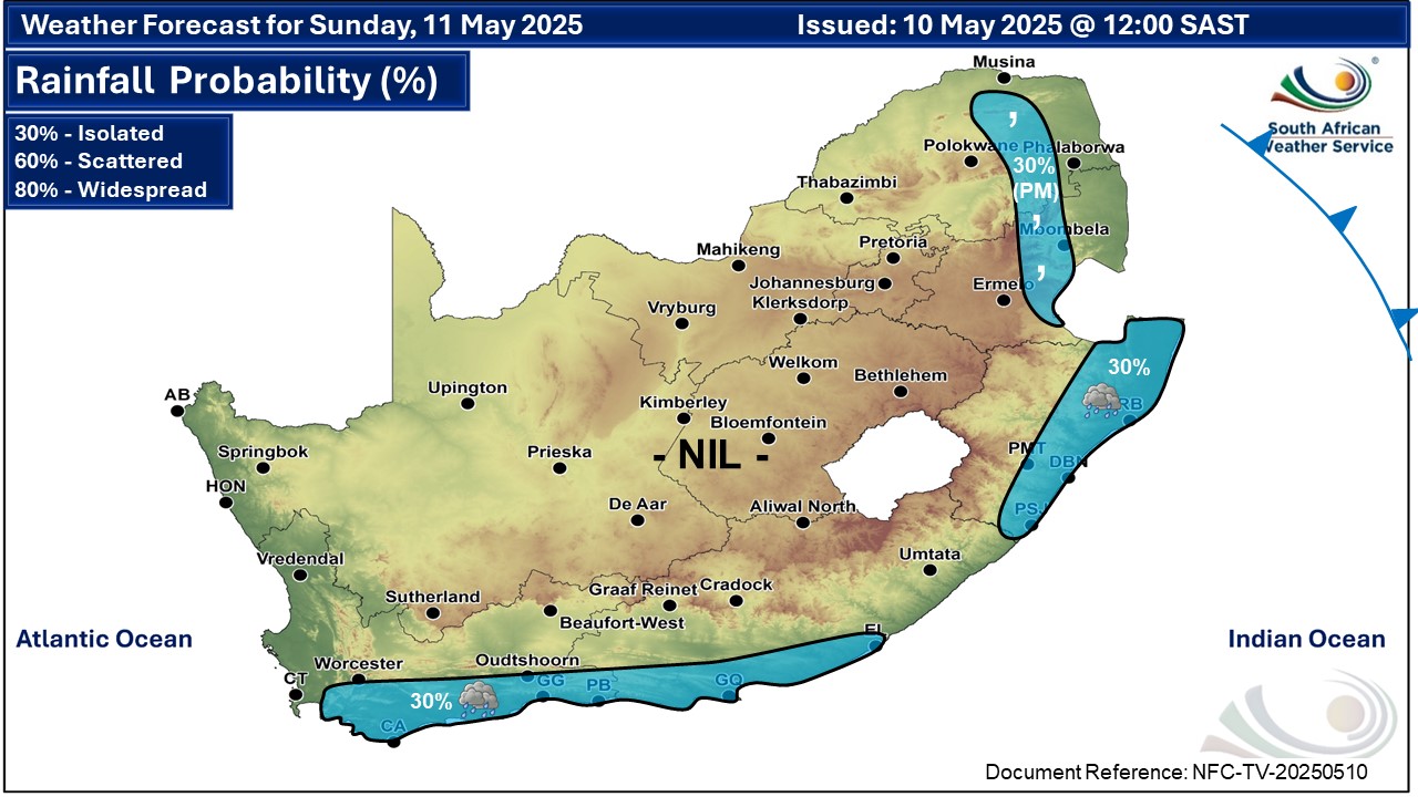
Maps for Sunday 11 May
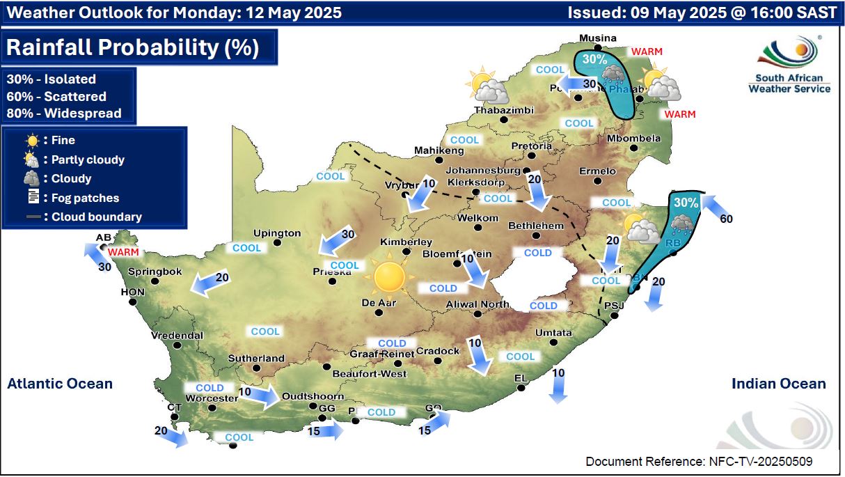
  Maps for Sunday 12 May
|