
     Swipe left or right for more maps, and see below for others
Warnings for disruptive rainfall, damaging winds and waves continue into SundayBy Staff WriterPublished: 9 August 2025 This forecast is for: Sun 10 August 2025 The maps cover: Sun 10 Aug – Tue 12 Aug
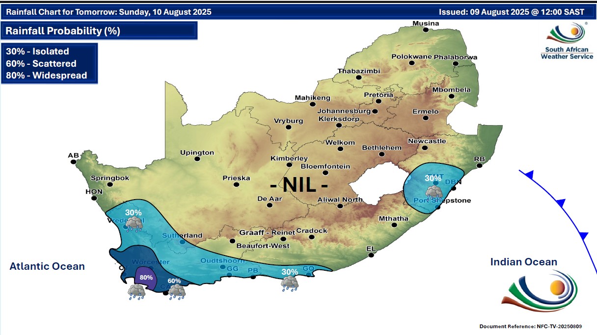
A newer forecast is available by clicking here. A cold front made landfall in the Western Cape on Saturday and the impacts will continue into Sunday. Very cold conditions are expected in places over the interior of the Eastern Cape. Warnings from the SA Weather Service for Sunday: A. level 2 warning for disruptive rainfall leading to localized flooding of susceptible formal and informal settlements or roads, and low-lying areas is expected over the south-western parts of Western Cape. B. level 2 warning for damaging waves resulting in disruptions of small harbours and ports, and difficulty in navigation as well as possible storm surge are expected between Lambert's Bay and Port Edward. C. level 2 warning for damaging coastal winds resulting in small vessels and personal watercraft being at risk of taking in water and capsizing in locality are expected between Saldanha Bay and Port Edward. Regional forecasts from the SA Weather Service for Sunday: 1. GAUTENG Fine and cool, but partly cloudy in the north. The expected UVB sunburn index: High 2. MPUMALANGA Fine and cool but warm in the Lowveld. It will be partly cloudy in the north-west. 3. LIMPOPO Partly cloudy in the south-west, otherwise fine and cool but warm in the Lowveld. 4. NORTH-WEST PROVINCE Fine and cool. 5. FREE STATE Fine and cold to cool. It will be windy in the east. 6. NORTHERN CAPE Fine in the east, otherwise partly cloudy and cool to cold with isolated showers and rain in the south-west where it will be very cold. The wind along the coast will be moderate to fresh south-easterly. 7. WESTERN CAPE Partly cloudy and cold with isolated to scattered showers and rain, except in the north-east, but widespread in the extreme south-west. It will be cloudy in the south. The wind along the coast will be moderate to fresh southerly to south-westerly along the west coast, otherwise strong westerly. It will become light and variable along the south-west coast from the evening. The expected UVB sunburn index: Low 8. WESTERN HALF OF THE EASTERN CAPE Partly cloudy and cool with morning showers along the coast, where it will be cloudy and windy. The wind along the coast will be Strong westerly reaching gale force at times in the early afternoon. 9. EASTERN HALF OF THE EASTERN CAPE Fine and cool becoming partly cloudy along the coast west of Kei Mouth. The wind along the coast will be strong westerly to south-Westerly. 10. KWAZULU-NATAL Fine and cool but warm in places in the north, becoming partly cloudy in the south-east from the afternoon with isolated showers and thundershowers. The wind along the coast will be light to moderate northerly to north-easterly, reaching fresh in places in the north, becoming moderate to fresh southerly to south-westerly in the south by late morning, spreading to Kosi Bay by the evening. The expected UVB sunburn index: Moderate Travellers forecasts from the SA Weather Service for Sunday: PRETORIA Partly cloudy. Minimum/Maximum: 07/23°C The expected UVB Sunburn Index: High JOHANNESBURG Fine. Minimum/Maximum: 06/22°C VEREENIGING Fine. Minimum/Maximum: 04/22°C MBOMBELA Fine. Minimum/Maximum: 10/25°C POLOKWANE Partly cloudy. Minimum/Maximum: 06/21°C MAHIKENG Fine. Minimum/Maximum: 07/21°C VRYBURG Fine. Minimum/Maximum: 04/19°C BLOEMFONTEIN Fine. Minimum/Maximum: 04/17°C KIMBERLEY Fine. Minimum/Maximum: 05/15°C UPINGTON Fine. Minimum/Maximum: 08/17°C CAPE TOWN Cloudy with scattered showers and rain in the early morning. Wind: Moderate westerly to south-westerly. Minimum/Maximum: 11/15°C The expected UVB Sunburn Index: Low GEORGE Cloudy with isolated showers and rain until the afternoon. Wind: Fresh to strong westerly to south-westerly. Minimum/Maximum: 09/16°C GQEBERHA Cloudy with morning showers. Wind: Strong to gale westerly to south-westerly. Minimum/Maximum: 12/16°C EAST LONDON Fine. Wind: Strong westerly to south-westerly Minimum/Maximum: 15/20°C DURBAN Partly cloudy from with isolated showers and thundershowers. Wind: Moderate to fresh south-westerly. Minimum/Maximum: 16/22°C The expected UVB Sunburn Index: Moderate RICHARDS BAY Fine. Wind: Moderate to fresh northerly to north-easterly. Minimum/Maximum: 15/27°C PIETERMARITZBURG Fine. Minimum/Maximum: 10/22°C This forecast is usually updated a few times per day.
Please be sure to send photos and videos to us via whatsapp and also tell us where and when they were taken. Follow our channels
Maps for Monday 11 August
 Maps for Tuesday 12 August

|