
FRIDAY WEATHER: LEVEL 6 warning with major travel disruption – snow possible and very cold
By Staff WriterPublished: 30 April 2026
This forecast is for: Fri 01 May 2026
The maps cover: Fri 01 May – Fri 01 May
| SHARE TO |
The latest forecast is available by clicking here.
The cut-off low will gradually move eastwards and is expected to exit the country by Friday, making for a generally dry weekend but cold in the interior.
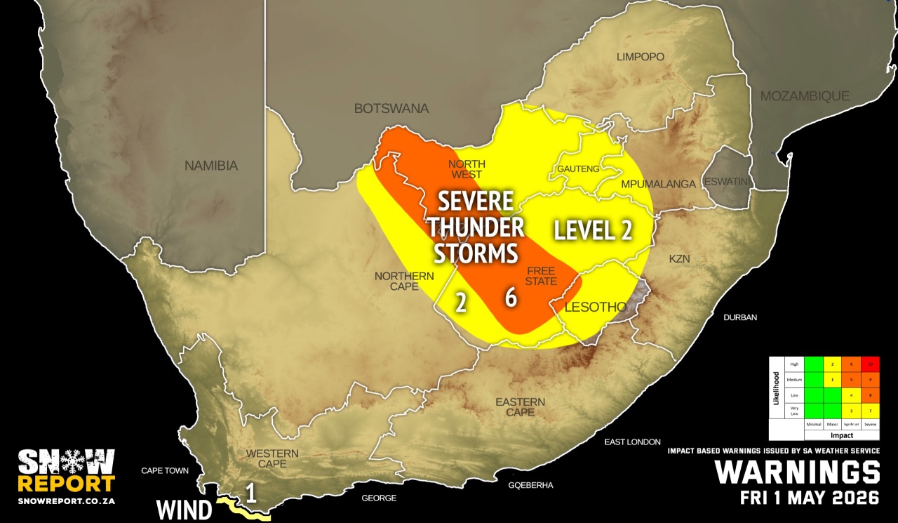
Warnings from the SA Weather Service for Friday:
A. level 6 warning for severe thunderstorms leading to damage or loss of infrastructures, settlements, property, vehicles, livelihood, and livestock, injuries and danger to life, and major travel disruptions are expected over the western parts of both Free State and North West.
B. level 2 warning for severe thunderstorms with heavy downpours, leading to localised flooding and damages to susceptible formal/informal settlements and infrastructure expected over the eastern parts of both Free State and North West and the extreme north-eastern parts of the Northern Cape.
B. level 2 warning for damaging coastal winds leading to localised disruption to beachfront activities is expected between Cape Point and Cape Agulhas.
SEE ALSO: Snowfall possible for Lesotho, the Drakensberg and the Eastern Cape on the long weekend.
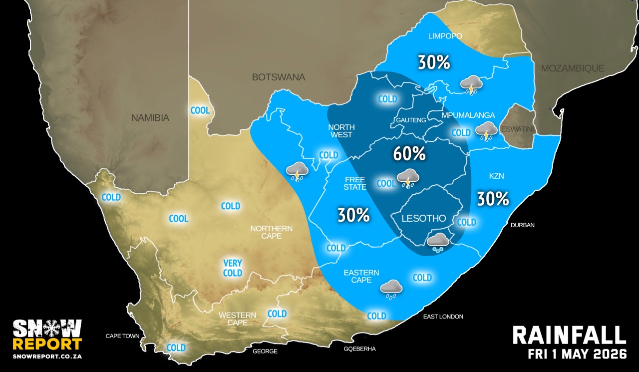
Regional forecasts from the SA Weather Service for Friday:
GAUTENG
Cloudy and cool with scattered showers and thundershowers.
MPUMALANGA
Cloudy in the morning, otherwise partly cloudy and cool to warm with isolated showers and thundershowers but scattered in the south-west.
LIMPOPO
Cloudy in the morning, otherwise partly cloudy and cool to warm with isolated showers and thundershowers in the central and western parts.
NORTH WEST
Cloudy and cool with scattered showers and thundershowers but isolated in the west, becoming partly cloudy in the afternoon.
THE FREE STATE
Cloudy and cool to cold with scattered showers and thundershowers but isolated in the west, becoming partly cloudy in the afternoon.
THE NORTHERN CAPE
Cloudy in the east at first, otherwise partly cloudy and cool with isolated showers in the extreme eastern parts, becoming fine in the west from the afternoon. The wind along the coast will be light to moderate north-westerly.
THE WESTERN CAPE
Cloudy over the western parts, otherwise partly cloudy and cool to cold. The wind along the coast will be moderate to fresh westerly to north-westerly, becoming strong to near gale force along the south-west coast towards the afternoon.
THE WESTERN HALF OF THE EASTERN CAPE
Morning fog patches over the interior, otherwise fine and cool to warm. The wind along the coast will be light to moderate south-westerly.
THE EASTERN HALF OF THE EASTERN CAPE
Cloudy and cool with isolated showers and thundershowers, becoming partly cloudy in the afternoon. The wind along the coast will be light south-westerly, becoming north-westerly in the evening.
KWAZULU-NATAL
Morning fog over the interior, otherwise cloudy and cool to warm with isolated showers and thundershowers but scattered in the extreme west. The wind along the coast will be fresh to strong northerly to north-easterly in the north, otherwise light to moderate southerly to south-westerly, spreading to Cape St Lucia in the afternoon.
Travellers forecasts from the SA Weather Service for Friday:
PRETORIA
Cloudy with scattered showers and thundershowers.
Minimum/Maximum: 12/20°C
JOHANNESBURG
Cloudy with scattered showers and thundershowers.
Minimum/Maximum: 11/18°C
VEREENIGING
Cloudy with scattered showers and thundershowers.
Minimum/Maximum: 11/20°C
MBOMBELA
Cloudy in the morning, otherwise partly cloudy with isolated showers and thundershowers.
Minimum/Maximum: 14/26°C
POLOKWANE
Partly cloudy with isolated showers and thundershowers.
Minimum/Maximum: 14/23°C
MAHIKENG
Partly cloudy with scattered showers and thundershowers.
Minimum/Maximum: 14/21°C
VRYBURG
Partly cloudy with isolated showers and thundershowers.
Minimum/Maximum: 12/21°C
BLOEMFONTEIN
Cloudy with isolated showers and thundershowers.
Minimum/Maximum: 10/17°C
KIMBERLEY
Partly cloudy with isolated showers and thundershowers.
Minimum/Maximum: 10/19°C
UPINGTON
Partly cloudy.
Minimum/Maximum: 11/20°C
CAPE TOWN
Cloudy at times.
Wind: Moderate to fresh northerly to north-westerly.
Minimum/Maximum: 13/18°C
GEORGE
Partly cloudy.
Wind: Light and variable.
Minimum/Maximum: 08/21°C
GQEBERHA
Fine.
Wind: Light to moderate south-westerly.
Minimum/Maximum: 11/21°C
EAST LONDON
Partly cloudy with isolated showers and thundershowers.
Wind: Light south-westerly, becoming north-westerly in the evening.
Minimum/Maximum: 14/22°C
DURBAN
Cloudy with isolated showers and rain.
Wind: Light to moderate south-westerly to southerly.
Minimum/Maximum: 19/24°C
RICHARDS BAY
Cloudy with isolated showers and rain.
Wind: Moderate to fresh north-easterly to northerly, becoming light to moderate south-westerly in the afternoon.
Minimum/Maximum: 15/26°C
PIETERMARITZBURG
Morning fog, otherwise cloudy with isolated showers and thundershowers.
Minimum/Maximum: 11/21°C
This forecast is usually updated a few times per day.
| SHARE TO |
Please be sure to send photos and videos to us via whatsapp and also tell us where and when they were taken.
Follow our channels