
SUNDAY WEATHER: Cold in the west with light snowfall possible and a thunderstorm warning for four provinces
By Staff WriterPublished: 28 February 2026
This forecast is for: Sun 01 March 2026
The maps cover: Sun 01 Mar – Sun 01 Mar
| SHARE TO |
The latest forecast is available by clicking here.
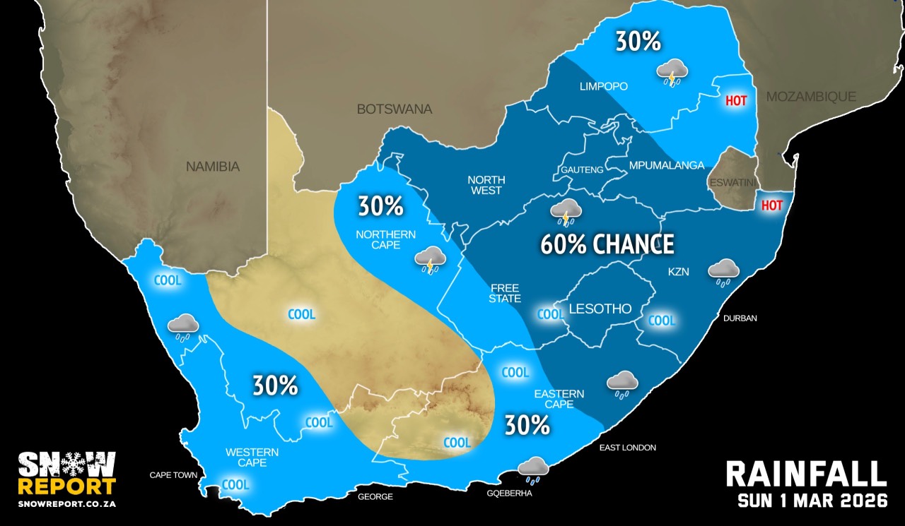
A light dusting of snow is possible on the Hex River range between Ceres and De Doorns in the early hours of Sunday morning, as well as on the Swartberg Range near Ladismith in the Western Cape later in the day.
From Monday it should be fine but cool in the western interior, otherwise partly cloudy and cool to warm with isolated showers and thundershowers but scattered to widespread in the east.
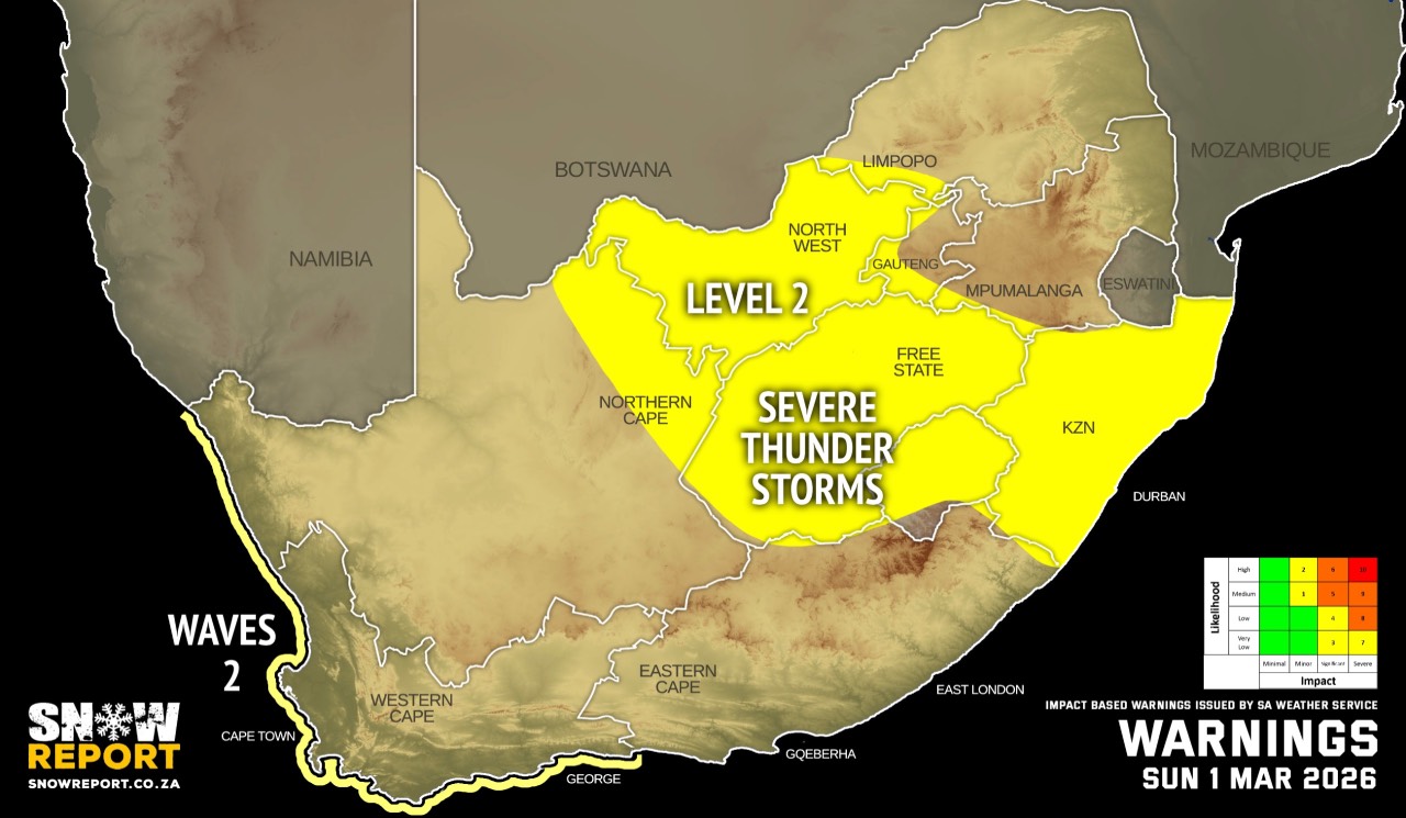
Warnings from the SA Weather Service for Sunday:
A. level 2 warning for severe thunderstorms with heavy downpours, damaging winds, hail and excessive lightning resulting in localised flooding and and damage to infrastructure and settlements are expected over KwaZulu-Natal, the Free State and North West.
B. level 2 warning for damaging waves leading to localised damage to coastal infrastructure and difficulty in navigation at sea are expected between Alexander Bay and Plettenberg Bay until Monday morning.
Extremely high fire danger conditions are expected in places over the southern part of the Free State, south-eastern part of Northern Cape, extreme south-western part of North West, northern part of Western Cape, KwaZulu-Natal and Eastern Cape.
Regional forecasts from the SA Weather Service for Sunday:
GAUTENG
Fine and warm, becoming partly cloudy from late morning with scattered afternoon thundershowers.
MPUMALANGA
Fine in the morning, otherwise partly cloudy and warm to hot with isolated to scattered showers and thundershowers. It will be very hot in the Lowveld.
LIMPOPO
Fine in the morning, otherwise partly cloudy and warm to hot with isolated showers and thundershowers but scattered in the south-western Bushveld.
NORTH-WEST
Partly cloudy and warm to hot, with scattered showers and thundershowers.
THE FREE STATE
Partly cloudy and warm to hot, with scattered showers and thundershowers, but isolated in the extreme west.
THE NORTHERN CAPE
Partly cloudy and cool to warm, with isoalted showers and thundershowers, except in the central part where it will be fine. The wind along the coast will be moderate to fresh southerly to south-easterly during early morning, becoming moderate easterly from late morning.
THE WESTERN CAPE
Partly cloudy and cool with showers and rain in the south-west spreading to the east from midday. The wind along the coast will be moderate to fresh south-westerly to southerly but strong along the south coast.
THE WESTERN HALF OF THE EASTERN CAPE
Partly cloudy and cool to warm, with light showers along the coast. The wind along the coast will be fresh to strong south-westerly.
THE EASTERN HALF OF THE EASTERN CAPE
Partly cloudy and cool to warm, with isolated to scattered showers and thundershowers and light rain and showers in the evening south of the escarpment. The wind along the coast will be fresh to strong south-westerly.
KWAZULU-NATAL
Partly cloudy and warm to hot but very hot to extremely hot in the north-east. Scattered showers and thundershowers are expected. The wind along the coast will be moderate to fresh northerly to north-easterly but light to moderate southerly to south-westerly in the extreme south, spreading to Cape St. Lucia by the evening.
Travellers forecasts from the SA Weather Service for Sunday:
PRETORIA
Fine at first, otherwise partly cloudy with scattered afternoon thundershowers.
Minimum/Maximum: 18/30°C
JOHANNESBURG
Fine at first, otherwise partly cloudy with scattered afternoon thundershowers.
Minimum/Maximum: 17/28°C
VEREENIGING
Fine at first, otherwise partly cloudy with scattered afternoon thundershowers.
Minimum/Maximum: 18/28°C
MBOMBELA
Cloudy at first, otherwise partly cloudy with isolated showers and thundershowers.
Minimum/Maximum: 19/33°C
POLOKWANE
Fine in the morning, otherwise partly cloudy with isolated showers and thundershowers.
Minimum/Maximum: 17/31°C
MAHIKENG
Partly cloudy with scattered showers and thundershowers.
Minimum/Maximum: 19/30°C
VRYBURG
Cloudy with scattered showers and thundershowers, becoming partly cloudy in the afternoon.
Minimum/Maximum: 20/31°C
BLOEMFONTEIN
Cloudy with scattered showers and thundershowers, becoming partly cloudy in the afternoon.
Minimum/Maximum: 18/26°C
KIMBERLEY
Partly cloudy with isolated showers and thundershowers.
Minimum/Maximum: 18/27°C
UPINGTON
Partly cloudy, becoming fine.
Minimum/Maximum: 16/26°C
CAPE TOWN
Partly cloudy, with showers and rain clearing from the evening.
Wind: Moderate south-westerly to southerly, becoming light and variable.
Minimum/Maximum: 15/19°C
GEORGE
Partly cloudy with showers and rain.
Wind: Light to moderate south-westerly to westerly, but fresh to strong during the afternoon.
Minimum/Maximum: 14/21°C
GQEBERHA
Partly cloudy with rain and showers.
Wind: Fresh to strong south-westerly.
Minimum/Maximum: 16/21°C
EAST LONDON
Partly cloudy with evening showers.
Wind: Fresh to strong south-westerly.
Minimum/Maximum: 18/26°C
DURBAN
Partly cloudy, becoming cloudy in the evening with scattered showers and thundershowers.
Wind: Light to moderate southerly to south-westerly.
Minimum/Maximum: 23/28°C
RICHARDS BAY
Fine to partly cloudy, becoming cloudy in the evening with scattered showers and thundershowers.
Wind: Light to moderate northerly to north-easterly, becoming light to moderate southerly to south-westerly.
Minimum/Maximum: 24/39°C
PIETERMARITZBURG
Partly cloudy, becoming cloudy in the late afternoon with scattered showers and thundershowers.
Minimum/Maximum: 19/32°C
This forecast is usually updated a few times per day.
| SHARE TO |
Please be sure to send photos and videos to us via whatsapp and also tell us where and when they were taken.
Follow our channels