
THURSDAY WEATHER: A wet New Year's Day in the east of the country with another level 4 warning
By Staff WriterPublished: 31 December 2025 [updated 1 January]
This forecast is for: Thu 01 January 2026
The maps cover: Thu 01 Jan – Sat 03 Jan
| SHARE TO |
The latest forecast is available by clicking here.
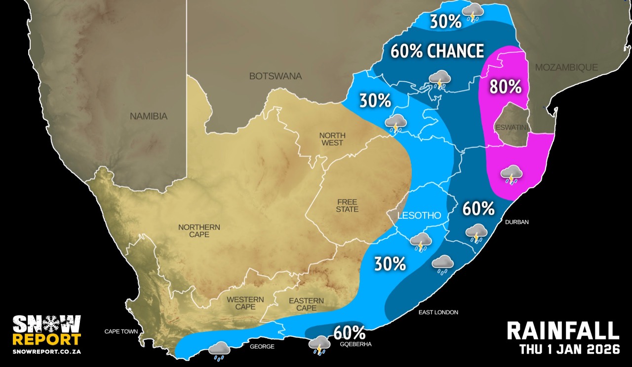
Partly cloudy conditions over the east on Thursday with isolated to scattered showers and thundershowers possible from the afternoon.
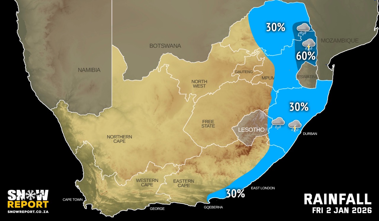
From Friday it should be partly cloudy and warm to hot, but cool in the east with isolated to scattered showers and thundershowers possible from the afternoon.
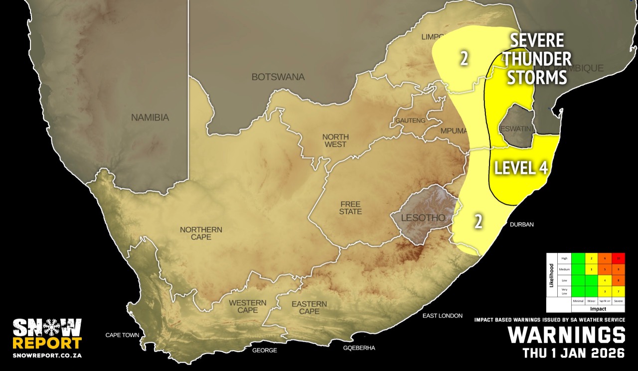
Warnings from the SA Weather Service for Thursday:
A. level 4 warning for severe thunderstorms with heavy downpours, damaging winds, excessive lightning and hail resulting in flooding and damages to infrastructure and settlements, as well as danger to life, are expected over the Lowveld and escarpment areas of Mpumalanga, including the extreme south-eastern parts of Limpopo.
B. level 2 warning for severe thunderstorms with heavy downpours, damaging winds, excessive lightning and large amounts of small hail, resulting in localised flooding of susceptible settlements and infrastructure, as well as and danger to life, are expected over the central and south-eastern parts of Limpopo (except for the extreme south-east), including the eastern Highveld of Mpumalanga.
Extremely high fire danger conditions are expected over the north-eastern parts of Northern Cape, and the extreme western parts of North West.
Regional forecasts from the SA Weather Service for Thursday:
GAUTENG
Partly cloudy and warm with isolated showers and thundershowers but scattered in the north. It will be hot in the extreme north.
MPUMALANGA
Partly cloudy and warm with isolated to scattered showers and thundershowers but widespread over the Lowveld and escarpment areas. It will be hot in places over the Lowveld.
LIMPOPO
Partly cloudy and warm to hot with isolated showers and thundershowers but isolated over the Limpopo Valley.
NORTH-WEST
Fine and warm to hot becoming partly cloudy in the east with isolated showers and thundershowers.
THE FREE STATE
Fine and warm to hot becoming partly cloudy in the east with isolated showers and thundershowers.
THE NORTHERN CAPE
Morning fog patches along the coast and adjacent interior, otherwise fine and warm to hot but very hot in places over the western interior. The wind along the coast will be light to moderate southerly to south-easterly.
THE WESTERN CAPE
Partly cloudy in the south with light morning rain or drizzle along the south coastal areas where it will be cool, otherwise fine and warm to hot. The wind along the coast will be light to moderate southerly to south-easterly, reaching fresh to strong along the west and south-west coast at times.
THE WESTERN HALF OF THE EASTERN CAPE
Cloudy with isolated showers and thundershowers in the morning over the southern parts IN THE MORNING, but scattered along the coast east of Cape St Francis, otherwise partly cloudy and warm. The wind along the coast will be light to moderate south-westerly, becoming southeasterly by the afternoon.
THE EASTERN HALF OF THE EASTERN CAPE
Cloudy and warm with scattered showers and thundershowers, but isolated in the northwest where it will be partly cloudy. The wind along the coast will be light to moderate south-westerly.
KWAZULU-NATAL
Morning fog patches, otherwise cloudy and cool to warm with scattered showers and thundershowers but widespread in the north-east. The wind along the coast will be moderate to fresh northerly to north-easterly, becoming light to moderate southerly to south-westerly in the south from late morning, spreading northwards in the afternoon.
Travellers forecasts from the SA Weather Service for Thursday:
PRETORIA
Partly cloudy with scattered showers and thundershowers.
Minimum/Maximum: 15/28°C
JOHANNESBURG
Partly cloudy with isolated showers and thundershowers.
Minimum/Maximum: 14/29°C
VEREENIGING
Partly cloudy with isolated showers and thundershowers.
Minimum/Maximum: 15/29°C
MBOMBELA
Partly cloudy with widespread showers and thundershowers.
Minimum/Maximum: 11/28°C
POLOKWANE
Partly cloudy with scattered showers and thundershowers.
Minimum/Maximum: 19/29°C
MAHIKENG
Fine becoming partly cloudy with isolated showers and thundershowers.
Minimum/Maximum: 19/32°C
VRYBURG
Fine.
Minimum/Maximum: 21/33°C
BLOEMFONTEIN
Fine.
Minimum/Maximum: 20/33°C
KIMBERLEY
Fine.
Minimum/Maximum: 21/33°C
UPINGTON
Fine.
Minimum/Maximum: 20/35°C
CAPE TOWN
Partly cloudy.
Wind: Moderate to fresh southerly to south-easterly.
Minimum/Maximum: 19/28°C
GEORGE
Cloudy with light rain/drizzle in the morning, becoming partly cloudy from the afternoon.
Wind: Light to moderate southerly to south-easterly.
Minimum/Maximum: 18/24°C
GQEBERHA
Cloudy with scattered showers and thundershowers, becoming partly cloudy by the afternoon.
Wind: Light to moderate south-westerly, becoming south-easterly in the afternoon.
Minimum/Maximum: 18/24°C
EAST LONDON
Cloudy with scattered showers and thundershowers.
Wind: Light to moderate south-westerly.
Minimum/Maximum: 19/25°C
DURBAN
Cloudy at times with scattered showers and thunder-showers from the afternoon.
Wind: Moderate northerly to north-easterly, becoming light to moderate southerly to south-westerly late morning.
Minimum/Maximum: 23/29°C
RICHARDS BAY
Cloudy at times with widespread showers and thundershowers from the afternoon.
Wind: Moderate to fresh northerly to north-easterly, becoming light to moderate south-westerly in the afternoon.
Minimum/Maximum: 21/32°C
PIETERMARITZBURG
Cloudy at times with scattered showers and thundershowers.
Minimum/Maximum: 18/26°C
This forecast is usually updated a few times per day.
| SHARE TO |
Please be sure to send photos and videos to us via whatsapp and also tell us where and when they were taken.
Follow our channels