
   Swipe left or right for more maps, and see below for others
Seven provinces now indicated in severe thunderstorm warnings for TuesdayBy Staff WriterPublished: 31 March 2025 [updated 1 April] This forecast is for: Tue 01 April 2025 The maps cover: Tue 01 Apr – Thu 03 Apr
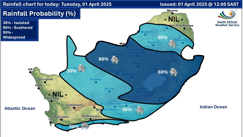
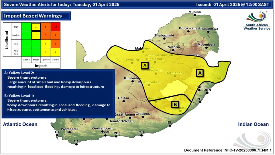
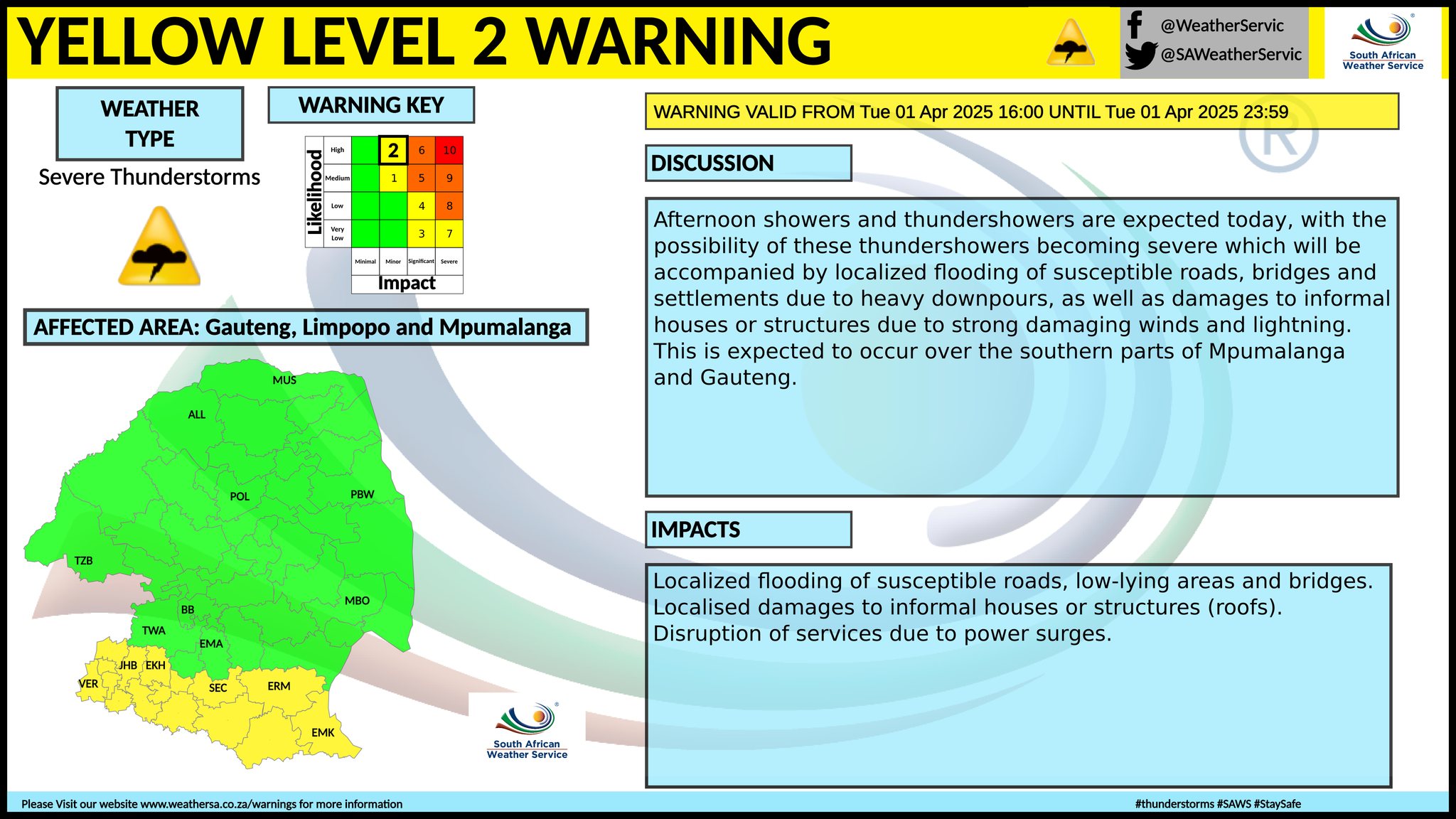
A newer forecast is available by clicking here. Partly cloudy and warm, but cool in places in the east with isolated to scattered showers and thundershowers over the central and eastern parts of the country on Tuesday, according to the SA Weather Service forecast. Warnings from the SA Weather Service for Tuesday: A. yellow level 2 warning severe thunderstorms resulting in damaging winds, excessive lightning, hail and heavy downpours leading to localised flooding and damage to property and infrastructure are expected over the north-eastern and western parts of KwaZulu-Natal, central and western parts of North West as well as the central and eastern parts of Free State. Gauteng and Mpumalanga were also added to the latest warning map above, as well as a sliver of the Northern Cape. B. yellow level 1 warning severe thunderstorms resulting in localised flooding, damage to settlements, property, vehicles and infrastructure are expected in places over northern parts of the Eastern Cape. Regional forecasts from SAWS for Tuesday: 1. GAUTENG Cloudy in the morning, otherwise partly cloudy and cool with scattered afternoon showers and thundershowers but isolated in the north where it will be warm. The expected UVB sunburn index: High 2. MPUMALANGA Morning fog in places in the highveld, otherwise partly cloudy and cool to warm with isolated to scattered showers and thundershowers, except in the north-east. 3. LIMPOPO Cloudy in the east in the morning, otherwise partly cloudy and warm with isolated showers and thundershowers in the central and south-western parts. 4. NORTH-WEST PROVINCE Partly cloudy and warm with scattered afternoon showers and thundershowers but isolated in the north-east. 5. FREE STATE Morning fog patches in places, otherwise partly cloudy and warm with scattered showers and thundershowers. 6. NORTHERN CAPE Fine in the west at first with morning fog patches along the coast, otherwise partly cloudy and cool to warm with isolated to scattered afternoon showers and thundershowers in the east. The wind along the coast will be strong southerly to south-easterly. 7. WESTERN CAPE Partly cloudy and cool to warm with a chance light rain along the south coast in the morning becoming fine from the west towards evening. The wind along the coast will be moderate to fresh southerly to south-westerly along the west coast becoming south-easterly from the evening, otherwise light to moderate westerly. The expected UVB sunburn index: High 8. WESTERN HALF OF THE EASTERN CAPE Partly cloudy and warm with isolated thundershowers, except in the south-west. It will be cool along the coast with a chance of light rain. The wind along the coast will be fresh to strong south-westerly 9. EASTERN HALF OF THE EASTERN CAPE Partly cloudy and warm with isolated showers and thundershowers but in the north and extreme eastern parts. A chance of Light rain is expected along the coast between Port Alfred and East London, mainly from the afternoon. The wind along the coast will be fresh to strong south-westerly 10. KWAZULU-NATAL Morning fog over the interior, otherwise partly cloudy and cool to warm with scattered showers and thundershowers. The wind along the coast will be moderate northerly to north-easterly north of Richards Bay in the morning, otherwise fresh to strong. It will become fresh to strong south-westerly south of Richards Bay in the evening. The expected UVB sunburn index: High Travellers forecasts from SAWS for Tuesday: PRETORIA Partly cloudy with isolated afternoon thundershowers. Minimum/Maximum: 16/25°C The expected UVB Sunburn Index: High JOHANNESBURG Partly cloudy with scattered afternoon thundershowers. Minimum/Maximum: 16/24°C VEREENIGING Partly cloudy with scattered afternoon thundershowers. Minimum/Maximum: 14/23°C MBOMBELA Morning fog patches, otherwise, partly cloudy with isolated showers and thundershowers. Minimum/Maximum: 19/28°C POLOKWANE Partly cloudy with isolated afternoon thundershowers. Minimum/Maximum: 17/27°C MAHIKENG Partly cloudy with scattered afternoon thundershowers. Minimum/Maximum: 17/26°C VRYBURG Partly cloudy with scattered afternoon thundershowers. Minimum/Maximum: 17/26°C BLOEMFONTEIN Partly cloudy with scattered afternoon thundershowers. Minimum/Maximum: 15/22°C KIMBERLEY Partly cloudy with scattered afternoon thundershowers. Minimum/Maximum: 16/24°C UPINGTON Partly cloudy with isolated afternoon thundershowers. Minimum/Maximum: 18/30°C CAPE TOWN Partly cloudy becoming fine from the evening. Wind: Light southerly to south-easterly in the morning becoming moderate from the afternoon. Minimum/Maximum: 17/23°C The expected UVB Sunburn Index: High GEORGE Cloudy with a chance of light morning rain Wind: Light westerly. Minimum/Maximum: 17/21°C GQEBERHA Cloudy with a chance of morning rain. Wind: Fresh to strong south-westerly Minimum/Maximum: 18/21°C EAST LONDON Partly cloudy with a chance of light rain from the afternoon. Wind: Fresh to strong south-westerly Minimum/Maximum: 20/23°C DURBAN Partly cloudy with scattered afternoon showers and thundershowers. Wind: Fresh to strong northerly to north-easterly, becoming south-westerly in the evening. Minimum/Maximum: 22/29°C The expected UVB Sunburn Index: High RICHARDS BAY Partly cloudy with scattered afternoon showers and thundershowers. Wind: Moderate to fresh northerly to north-easterly, becoming strong south-westerly in the evening. Minimum/Maximum: 23/33°C PIETERMARITZBURG Morning fog, otherwise partly cloudy with scattered afternoon thundershowers. Minimum/Maximum: 17/27°C This forecast is usually updated a few times per day.
Please be sure to send photos and videos to us via whatsapp and also tell us where and when they were taken. Follow our channels
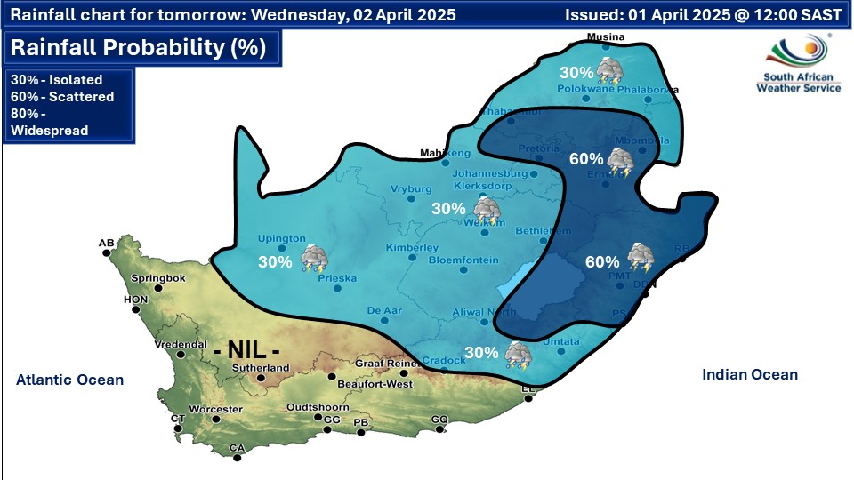
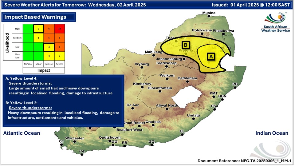
Maps for Wednesday 2 April
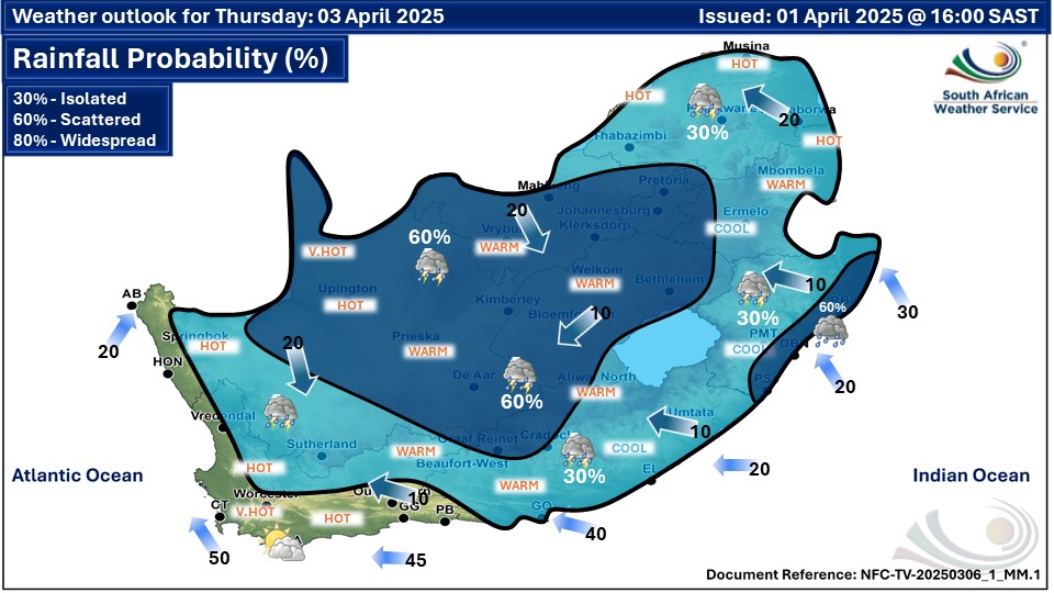
  Maps for Thursday 4 April
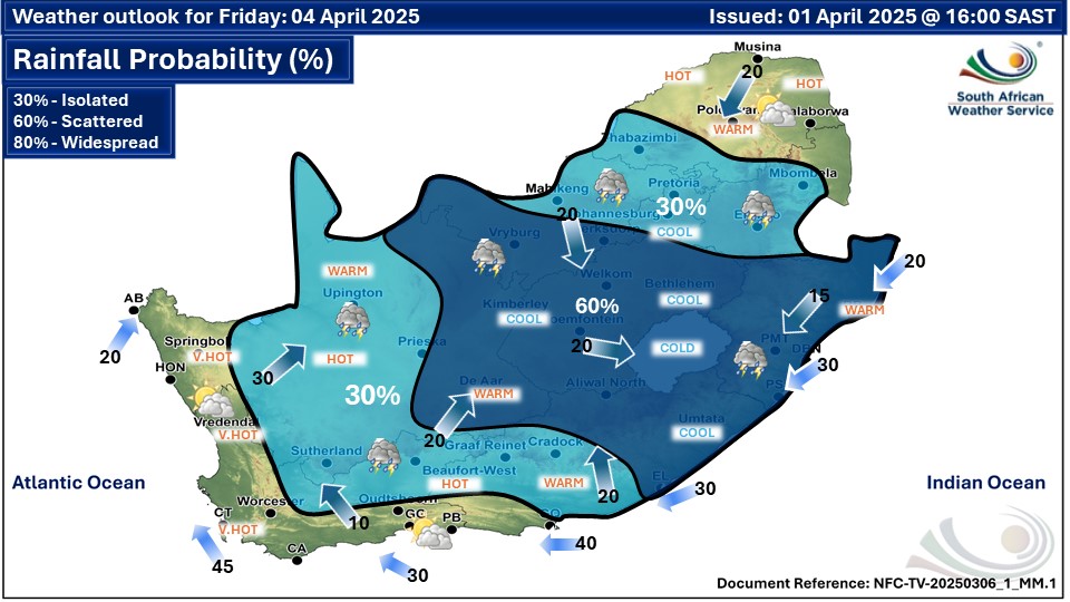
 Maps for Friday 4 April
|