
        Swipe left or right for more maps, and see below for others
Two cold fronts bringing strong winds, rough seas, heavy rain and possibly snow next weekBy Staff WriterPublished: 16 May 2025 [updated 19 May] This forecast is for: Mon 19 May 2025 The maps cover: Mon 19 May – Fri 23 May
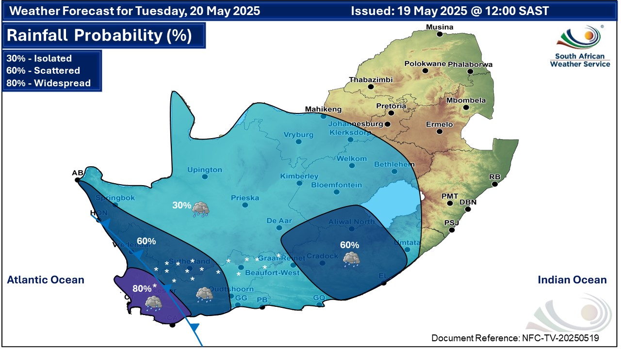
Two cold frontal systems are expected to develop early next week (19-23 May 2025) with a high likelihood of disrupting the current rainless and incident-free mild to warm weather condition that has been prevailing for some days. The SA Weather Service is closely monitoring these systems with the view to issue out weather impacts associated with the cold fronts across parts of the Western Cape province from Monday 19 May through to Wednesday 21 May, when strong winds and rough sea conditions are expected to spread to the south coast and the Eastern Cape. SEE ALSO: Light to heavy snowfall in four SA provinces and Lesotho on Tuesday and Wednesday. On Monday a cold front will make landfall over the south-western parts of the country, resulting in wet, cold, and windy conditions over the western parts of the Western Cape. While this system will not be intense, it serves as a precursor to the more significant weather system that will follow the next day. On Tuesday the above-mentioned weather conditions will spread to the east, affecting the Namakwa District of the Northern Cape and the Eastern Cape. This continued impact of the weather conditions will be due to a well-developed cold front, resulting in isolated to scattered showers and rain. Weather Warnings from SAWS for Tuesday A. level 2 warning for damaging waves as per the map above, resulting difficulty in navigation at sea and localised disruptions to small harbours and ports. B. level 2 warning for damaging winds off the coast, as per the map above. C. level 2 warning for disruptive rainfall over the Cape Winelands, Cape Metropole, West Coast and western parts of the Overberg Districts of the Western Cape on Tuesday, leading to localised flooding of susceptible formal and informal settlements, roads, low-lying areas and bridges. D. level 2 warning for damaging interior winds as per the map above leading to longer travel times, problems for high-sided vehicles on prone routes, localised damage to informal and formal settlements and communication/power disruptions. Rainfall accumulations are expected to range between 15mm and 25mm, with a possibility of reaching 30mm to 50mm in mountainous areas. The persistent and continuous rainy conditions may lead to localised floods, particularly in areas with poor drainage and low-lying regions. Strong and gusty westerly to north-westerly winds, with wind speeds averaging between 55km/h and 65km/h, are expected across the Western Cape, Northern Cape, and the Eastern Cape more especially over the interior. Possible impacts might result in outdoor activities being disrupted with a high likelihood of localised damage to infrastructure, uprooted trees, increased traveling time on the roads, problems for high sided vehicles, especially along the national routes through the provinces as well as disruptions to power lines. For maritime operators and coastal residents, westerly to north-westerly gale-force winds (65-75km/h) are expected along the coastline, particularly from Alexander Bay through to Plettenberg Bay. These high winds will result in very rough seas on Tuesday and Wednesday, leading to sea conditions that could impact small vessels and coastal activities. There is also a possibility of abnormal waves along the south-eastern coast, with wave heights of 5m to 6.5m, occasionally peaking at 7m, with a 10 seconds wave period on Wednesday. In addition, freezing levels are expected to drop considerably, creating conditions favourable for some snowfall over high-lying areas and a general drop in temperatures. These very cold conditions are expected to spread to the central and the eastern parts of the country from Tuesday late evening, persisting until Friday morning.
Please be sure to send photos and videos to us via whatsapp and also tell us where and when they were taken. Follow our channels
|