
![Snow forecast map for 20 May 2024 [updated 2 June]](/img/SR-Map-29-May-2024-F9-cropped.jpg)
Widespread and heavy snowfall as SAWS issues disruptive snow warning20 May 2024 [updated 2 June]By Staff Writer
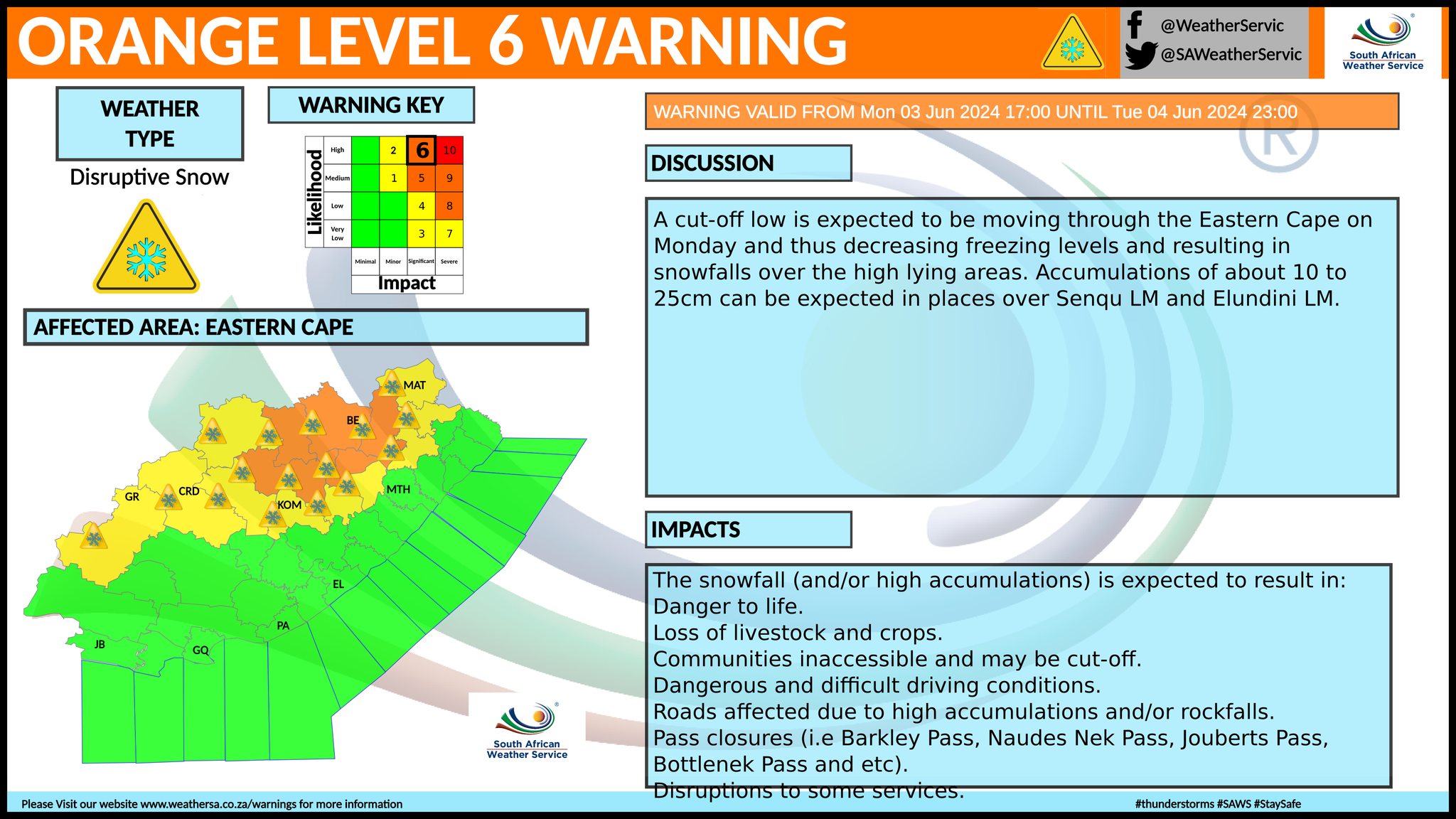
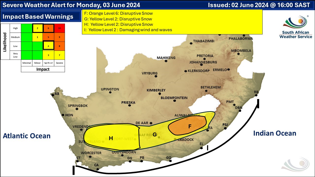
Widespread snowfall is possible as temperatures look set to drop well below freezing in some areas due to a cut-off low. Snow has already fallen in the Western Cape and is currently indicated between 30 May and 4 June across five provinces. Snow is also likely for Lesotho and possible for Namibia. The heavy snowfall expected some high elevations in some areas will likely result in challenging driving from late Sunday into Tuesday, with the South African Weather Service posting a number of disruptive snow warnings, including an orange level 6 warning, on Sunday afternoon for Monday (see map below). See the latest snow photos here. The following is a breakdown of regions and dates that apply: Western Cape A very light dusting has already fallen on the Hex River mountains and a little more is possible for Tuesday, but no low-level snow is expected in this area. The hotspot for snow is likely to be around Beaufort West and Murraysburg on Monday and into Tuesday, with more than 10cm possible. The Swartberg range near Ladismith, Calitzdorp, Prince Albert, Oudtshoorn, De Rust and the mountains around Uniondale are also currently indicated to get a some snowfall from late on Sunday and overnight into Tuesday. Northern Cape Light to rather heavy snowfall is possible for a good part of the Northern Cape on Monday and Tuesday, including around Calvinia, Sutherland, Fraserburg, Loxton, Carnarvon, Victoria West, Richmond, Noupoort, Postmasburg, Prieska and areas marked on the map. Accumulated snowfall could be as much as 25cm at higher elevations near Sutherland, Fraserburg, Loxton and Carnarvon. Eastern Cape On Monday and Tuesday anything from light to heavy snowfall is indicated for the many of the usual areas of the Eastern Cape, including Willowmore, Graaff-Reinet, Nieu-Bethesda, Tarkastad, Steynsburg, Hofmeyr, Molteno, Sterkstroom, Jamestown, Dordrecht, Burgersdorp, Lady Grey, Barkly East, Seymour and Aliwal North. The high ground and high mountain passes near Rhodes and Tiffindell (currently closed) are looking like they might see more than 30cm of accumulated snowfall by Tuesday and this will definitely make driving over the highest passes very challenging. Gauteng and North West Snow is no longer indicated for this region. KwaZulu-Natal No very low-level snow is currently expected across the province but Sani Pass is likely to get some snow. Free State Light snowfall is a possibility on Monday mainly in the eastern Free State, including around Zastron, Clarens, Fouriesburg, Ficksburg, Senekal, Heilbron, Kroonstad, Memel, Trompsburg, Petrus Steyn, Reddersburg, Thaba Phatshwa, Bethlehem, Harrismith, Reitz and even Welkom. Lesotho Widespread snowfall is looking possible for Lesotho on Sunday and Monday, including Maseru, with more than 10cm possible around Afriski and slightly less around the top of Sani Pass. This might result in challenging driving conditions especially on high mountain passes. Namibia Light snowfall been been consistently indicated for Namibia over the past few days. At this stage very light snowfall is on the radar for the high-ground near Rosh Pinah and Aus on Sunday. The snow forecast may still change and updates will be posted on the weekend. The overall weather forecast including warnings (other than snow) can be found here. The map indicates where we are seeing the possibility of snow, but it may not fall in all of the areas shown on the map. As with any forecast of any kind (temperature, clouds, rain, wind), what eventually happens may or may not be similar to the forecast. Please be sure to send photos and videos to us via whatsapp and also tell us where and when they were taken. See below for a link to our whatsapp channel but since the link does not work in the instagram app you will need to send us a whatsapp message and we'll send you a link. Follow our channels
Standard users are welcome to use the standard sharing buttons on this page to share our content. It is NOT acceptable to download or screen grab for reposting. Other media and channels need to send us a request in order to embed or use of our forecasts, maps, as well as images and video from our users that we post (before doing so).
Issued on Monday by SAWS
 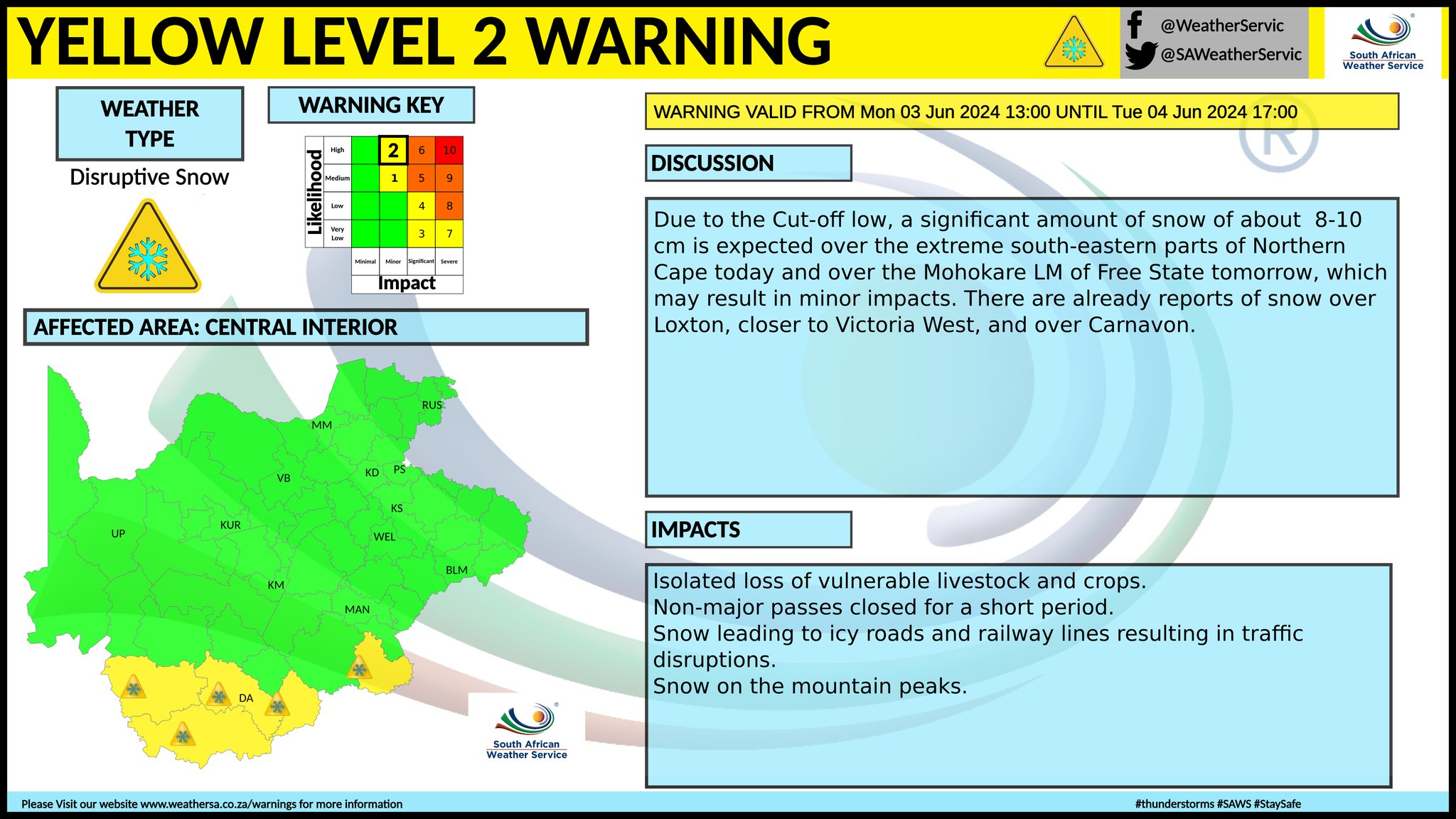 Issued on Sunday by SAWS
 |