
![Snow forecast map for 3 August 2026 [updated 10 August]](/img/SR-Map-9-August-2026-F7-cropped.jpg)
Chances for snow in Gauteng and Mpumalanga looking good from Monday night By Staff Writer
Published: 3 August 2026 [updated 10 August] This forecast covers: Sun 09 Aug – Thu 13 Aug
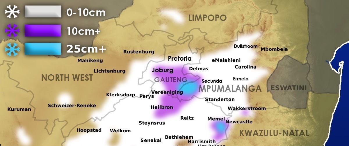
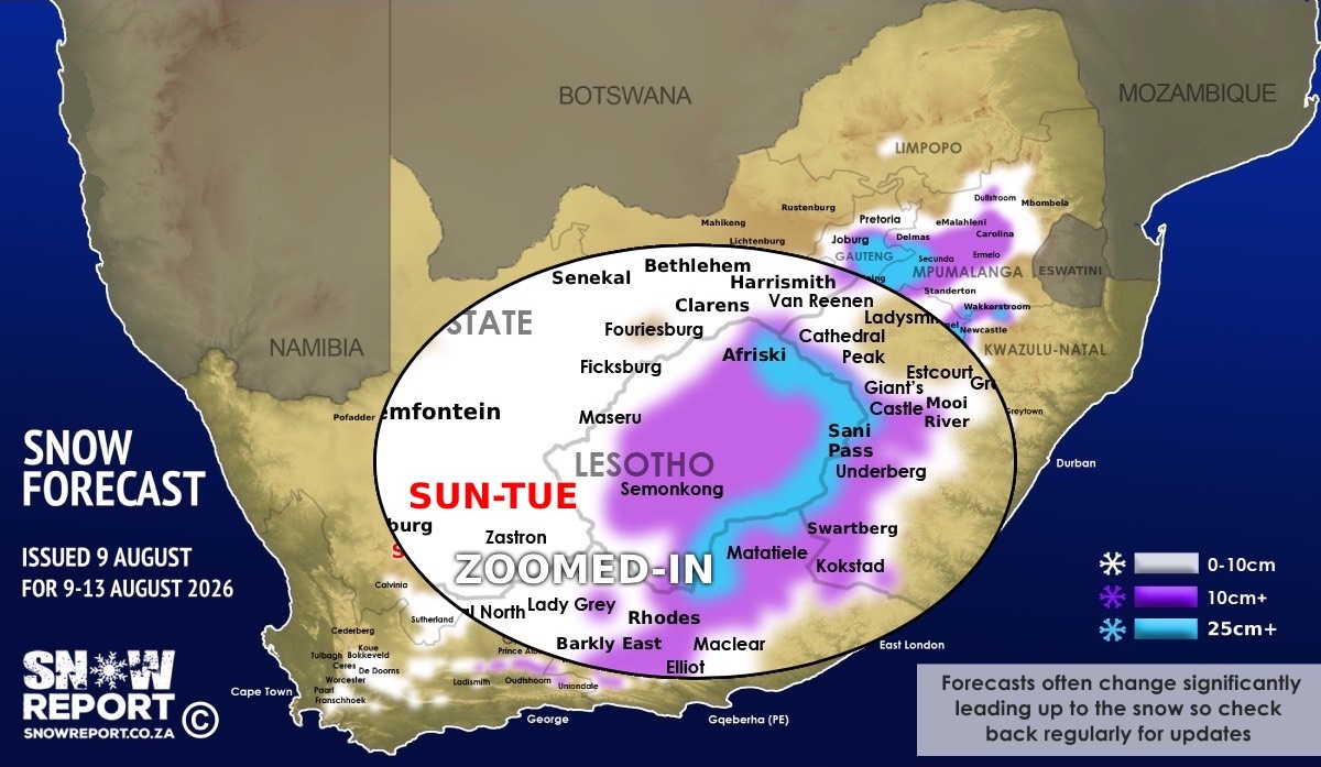
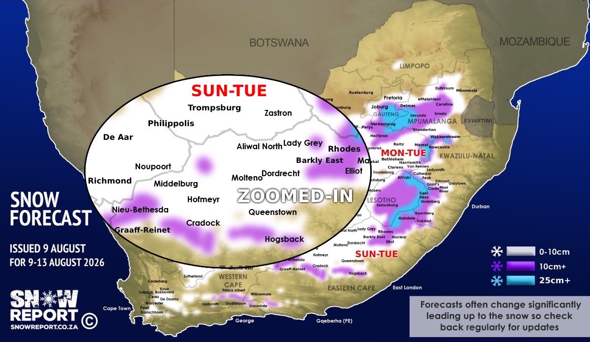
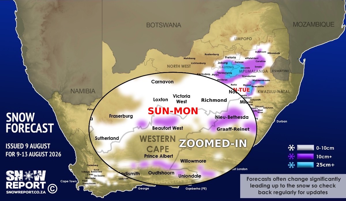
Widespread snowfall is on the radar in South Africa and Lesotho from Sunday until Tuesday (and possibly Thursday beyond) with snow indicated for all South African provinces. Zoomed-in maps with more detail for each region can be found below this forecast. The maps have not been updated on Monday yet, except for the map showing Gauteng and Mpumalanga below. We would call the chances of snowfall in parts of Johannesburg and Gauteng as being quite good, with some chance of light snowfall or sleet possible in Centurion and parts of Pretoria too. We consider the chances of more than 10cm of snow in some parts of Gauteng to be reasonable, with a chance of heavy snowfall in some areas. The SA Weather Service has already issued a number of early impact warnings for disruptive snowfall and more will likely be added (details below). At this point the data indicates the possibility for snowfall across Gauteng, Mpumalanga, North West, Free State, KwaZulu-Natal, the Northern Cape, the Western Cape and the Eastern Cape in South Africa with a small part of Limpopo indicated too. The snow indicated for the southern half of the country is indicated from Sunday and Monday, while the snow for the north is indicated from Monday and into Tuesday. Major weather models currently indicate over 25cm of snow for the high-ground and mountain peaks in some areas, while over 40cm is possible at high elevations in the Eastern Cape, the Free State, the KwaZulu-Natal Drakensberg, Lesotho and even parts of Mpumalanga and Gauteng. A number of hotspots in South Africa where more than 25cm is POSSIBLE, as per the map, include parts of Gauteng, Mpumalanga, the Free State and the Eastern Cape. Models vary on snow depths in most regions so areas marked in purple or blue above may receive much less than the maximum indicated on the maps. A number of major roads in Gauteng, Mpumalanga, KwaZulu-Natal, the Free State, the Eastern Cape and the Northern Cape are currently indicated to see snowfall and so it's best to keep an eye on our forecasts if you're planning to travel. While the N3 at Van Reenen and around Mooi River are not expected to see as heavy snow as in late 2024 when thousands of people were stuck in their vehicles for days, enough snow is expected to cause driving challenges. The snow will certainly make driving a major challenge in some areas and we believe that more warnings will be issued for Monday and Tuesday. We would like to remind everyone that a forecast for places like Johannesburg can change dramatically in a short time, but it has been quite consistent for days with only the quantity changing. Here are some of the places that are indicated to receive snow, sleet or a mixture between the two. This may be in the place itself OR on the high-ground or mountains nearby. GAUTENG Johannesburg, Heidelberg, Vereeniging, Randburg, Krugersdorp, Lenasia, Carltonville, Rayton, Krugersdorp, Centurion, Mamelodi, Pretoria, Cullinan, Bapsfontein, Alberton, Boksburg, Brakpan, Nigel, Soweto, Bronkhorstspruit. MPUMALANGA Secunda, Kriel, Hendrina, Carolina, Ermelo, Daggakraal, Wakkerstroom, Amersfort, Volksrust, eMalahleni, Middelburg, Lothair, Lydenburg, Dullstroom, Sabie, Delmas, Bethal. THE FREE STATE Clarens, Fouriesburg, Ficksburg, Harrismith, Memel, Warden, Heilbron, Petrus Steyn, Villiers, Deneysville, Ladybrand, Trompsburg, Reddersburg, Smithfield, Springfontein, Senekal, Parys, Bethlehem, Steynsrus, Hennenman, Theunissen, Bloemfontein, Wepenaar, Fauresmith. THE EASTERN CAPE Matatiele, Barkly East, Rhodes, Elliot, Ugie, Maclear, Lady Grey, Aliwal North, Molteno, Dordrecht, Hofmeyr, Steynsburg, Middelburg, Nieu-Bethesda, Graaff-Reinet, Seymour, Tarkastad. KWAZULU-NATAL Swartberg, Kokstad, Underberg, Himeville, Kamberg, Bulwer, Boston, Howick, Mooi River, Estcourt, Bergville, Van Reenen, Newcastle, Nottingham Road. THE NORTHERN CAPE Loxton, Carnarvon, Fraserburg, Hanover, De Aar, Richmond, Noupoort, Sutherland, Colesburg, Griekwastad, Prieska, Victoria West, Kimberley. NORTH WEST Klerksdorp, Potchefstroom. THE WESTERN CAPE Murraysburg, Beaufort West, Swellendam, the Hex River range and most of the peaks in the south-west, the Swartberg range near Oudtshoorn, the mountains around Uniondale. Warnings from the SA Weather Service from Sunday: A. level 6 warning for disruptive snow leading to disruptions to livelihood, major traffic disruptions and some communities temporary inaccessible over Dr Beyers Naude, Chris Hani, Senqu, Elundini and Matatiele Local Municipalities of the Eastern Cape on Sunday into Tuesday. B. level 2 warning for disruptive snow leading to localised traffic disruptions, isolated loss of livestock and crops and localised disruptions to services in places over Koukamma, Kouga, Blue Crane, Raymond Mhlaba, Amahlathi, Intsika Yethu, Dr AB Xuma, Mhlontlo, and Mzimvubu Local Municipalities of the Eastern Cape on Sunday into Tuesday. C. level 2 warning for disruptive rain leading to localised flooding of susceptible settlements, roads and bridges in places over Koukamma Local Municipality of the Eastern Cape on Sunday. D. level 2 warning for disruptive snow in the eastern parts of KwaZulu-Natal for Sunday and Monday. At this stage there is potential for significant impacts on travel in some parts of South Africa and Lesotho. Hikers that are expecting to be in the Drakensberg on Sunday onwards need to be well prepared for conditions that may result in them being snowed in for a few days. This forecast may still change over the coming days. ALSO READ: See the photos of the disruptive snow in South Africa and Lesotho in late July 2026. ALSO READ: Be prepared for safe winter travel and snow chasing trips. The map indicates where we are seeing the possibility of snow, but it may not fall in all of the areas shown on the map. As with any forecast of any kind (temperature, clouds, rain, wind), what eventually happens may or may not be similar to the forecast. Snow indicated may reduce or vanish completely in some areas, or the dates and times may change. Follow our channels
Standard users are welcome to use the standard sharing buttons on this page to share our content. It is NOT acceptable to download or screen grab for reposting. Other media and channels need to send us a request in order to embed or use of our forecasts, maps, as well as images and video from our users that we post (before doing so).
|