
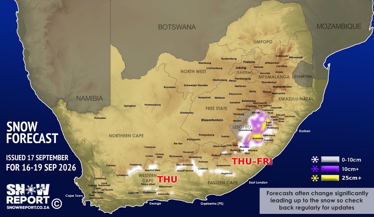
![Snow forecast map for 13 September 2026 [updated 17 September]](/img/SR-Map-17-September-2026-F4-cropped.jpg)
Snow indicated for Lesotho and South Africa until the weekend – disruptive snowfall warning issued By Staff Writer
Published: 13 September 2026 [updated 17 September] This forecast covers: Thu 17 Sep – Sat 19 Sep
Snowfall is on the radar for South Africa and Lesotho from Wednesday until at least Friday this week. See below for the map without the zoomed-in section which shows more detail. Heavy snowfall is possible for some areas, with up to 50cm indicated at high elevations in parts of Lesotho. In the Western Cape the high-peaks around Worcester, Ceres and De Doorns may get some light snowfall on Wednesday. The high-ground outside Beaufort West, Murraysburg and the Swartberg range near Ladismith, Oudtshoorn, Prince Albert and De Rust may also get some light snow on Wednesday and Thursday. In the Northern Cape the high-ground between Sutherland and Fraserburg is on the radar for light snow on Wednesday and Thursday. In the Eastern Cape the high-ground around Nieu-Bethesda, Graaff-Reinet, Middelburg, Cradock, Hogsback and Maclear may get lighter snow, while more than 10cm is indicated at higher elevations around Barkly East, Khowa (Elliot), Rhodes and Matatiele from Thursday and especially on Friday. The high-ground between Quacha's Nek in Lesotho and Matatiele in South Africa may see significant snowfall, as per the map, and a level 2 warning for disruptive snowfall has been issued by the SA Weather Service for this area for Thursday and Friday. The slopes of the Drakensberg in KwaZulu-Natal, and especially in the southern region around Himeville, Underberg, Swartberg and Kokstad are indicated for snow from Thursday and especially on Friday as per the map. Sani Pass is currently expected to get some snow – possibly much lower down the pass. Lesotho is again on the radar for heavy snow with more than 10cm in many areas as marked in purple on the map, and more than 25cm in areas marked in yellow and up to 50cm at higher elevations from Thursday, especially on Friday and possibly early on Saturday. Hikers that are expecting to be in the Drakensberg this week need to be well prepared for very cold conditions and being snowed-in. This forecast may still change over the coming days, but it has been quite stable for days already. ALSO READ: Be prepared for safe winter travel and snow chasing trips. The map indicates where we are seeing the possibility of snow, but it may not fall in all of the areas shown on the map. As with any forecast of any kind (temperature, clouds, rain, wind), what eventually happens may or may not be similar to the forecast. Snow indicated may reduce or vanish completely in some areas, or the dates and times may change. Follow our channels
Standard users are welcome to use the standard sharing buttons on this page to share our content. It is NOT acceptable to download or screen grab for reposting. Other media and channels need to send us a request in order to embed or use of our forecasts, maps, as well as images and video from our users that we post (before doing so).
|