
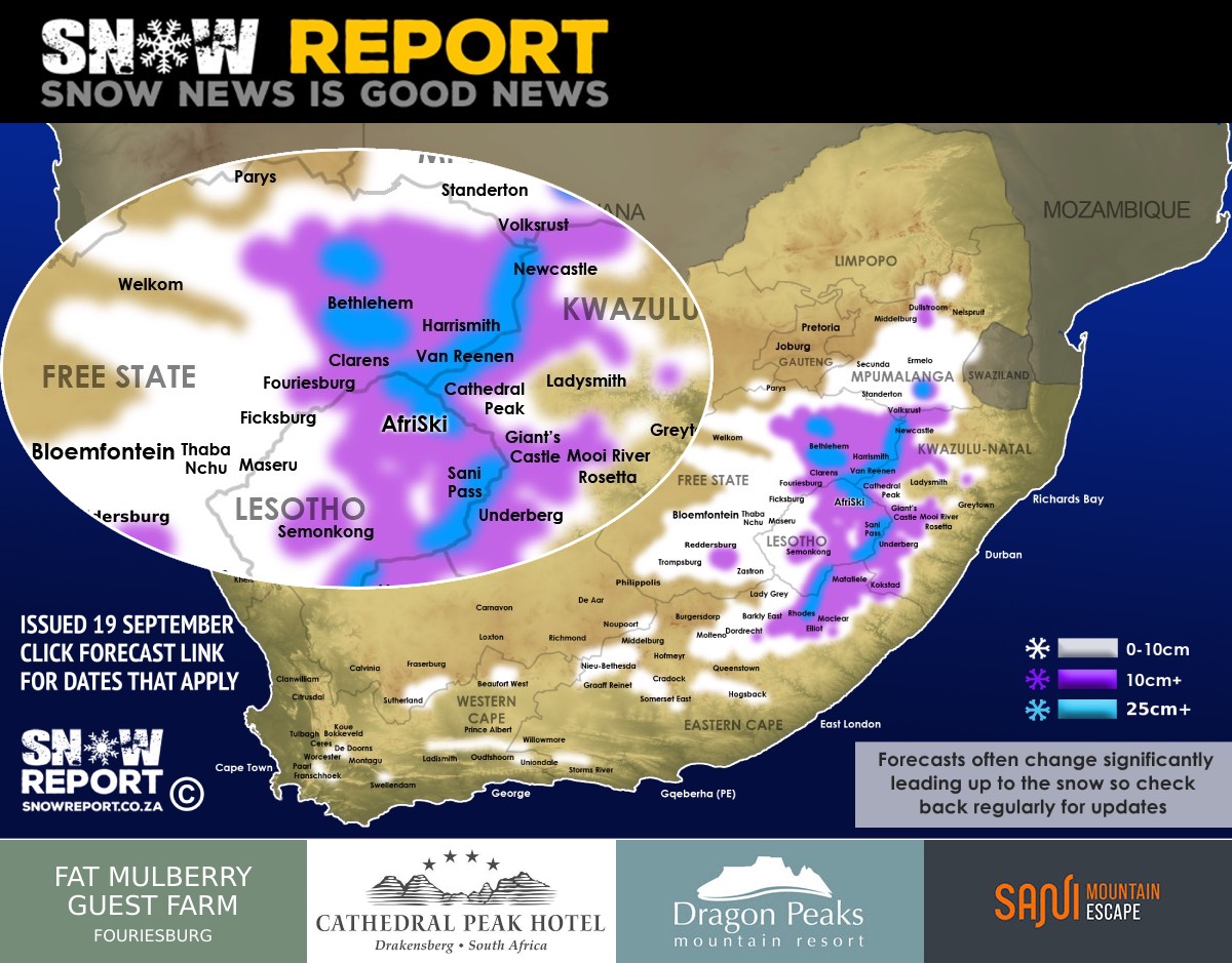
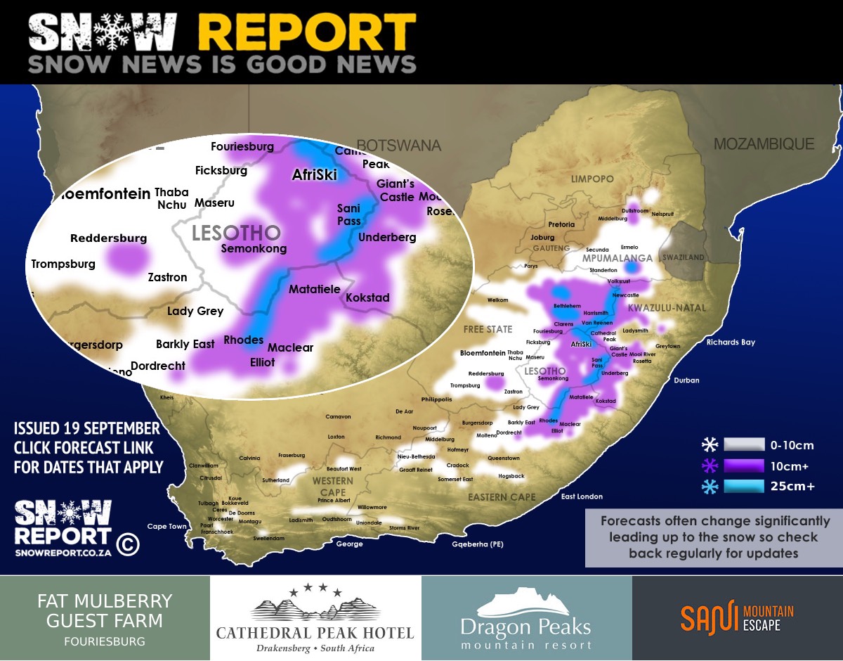
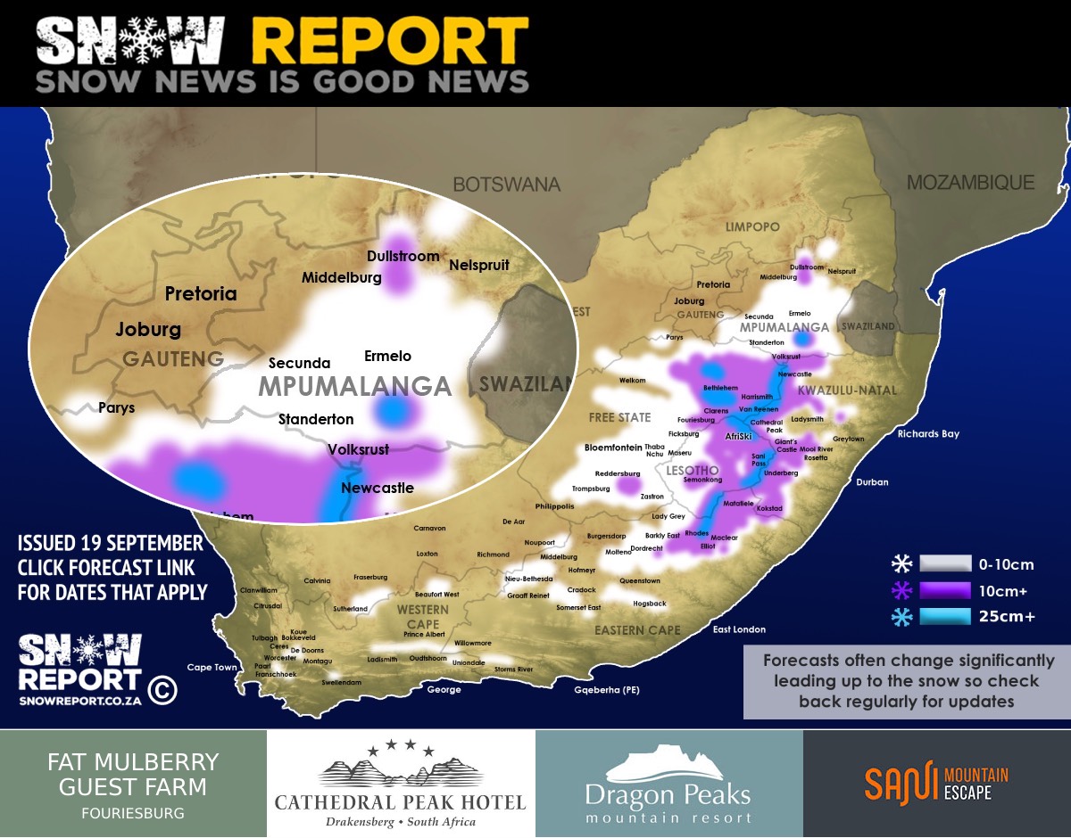
![Snow forecast map for 16 September 2024 [updated 21 September]](/img/SR-Map-19-September-2024-F4-cropped.jpg)
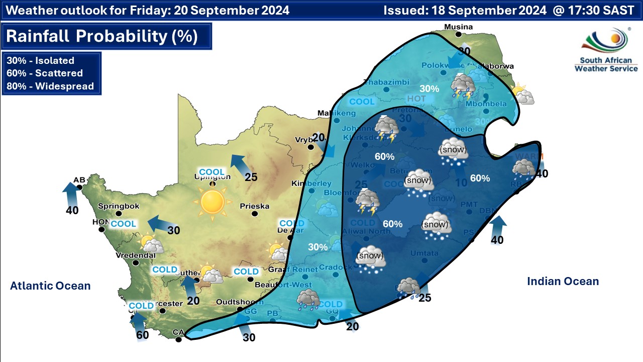
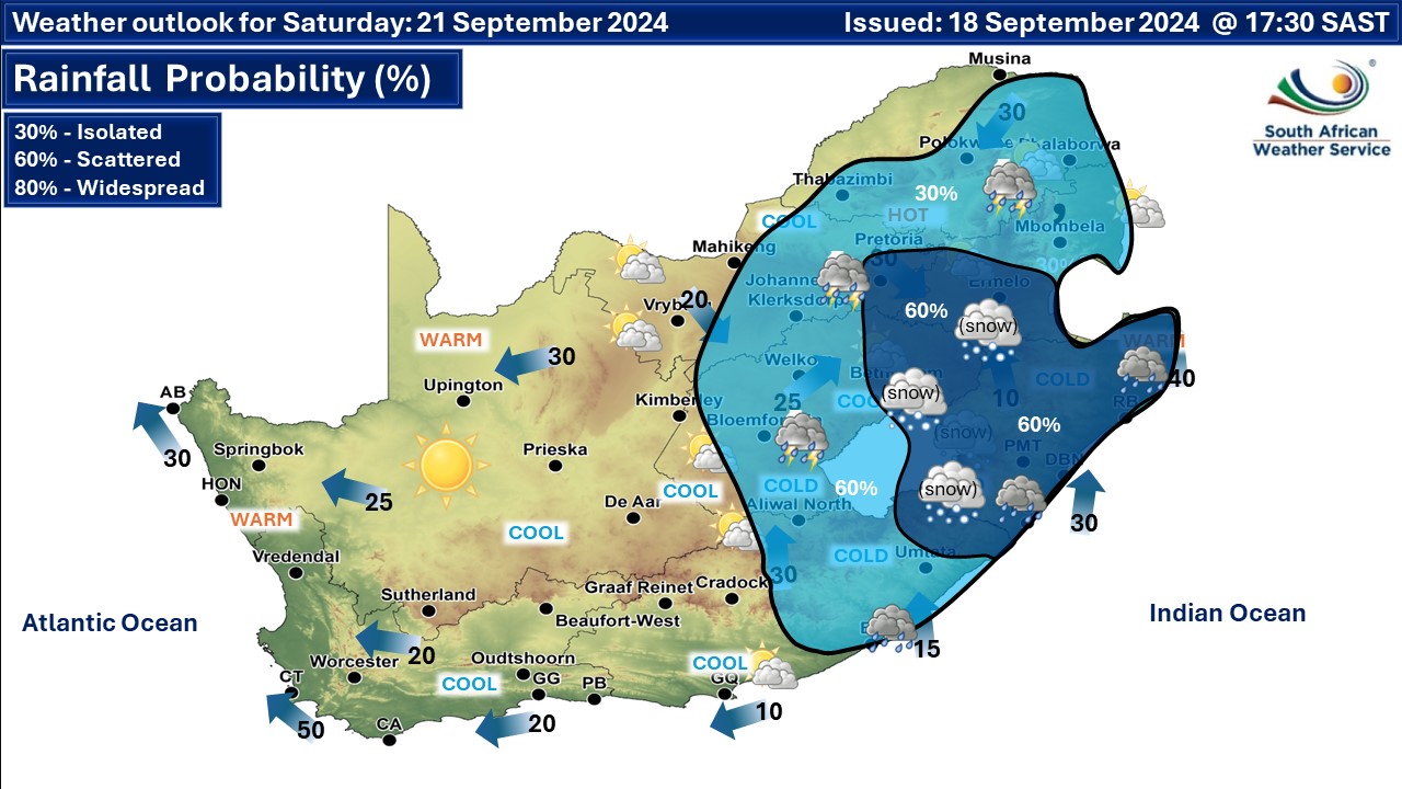
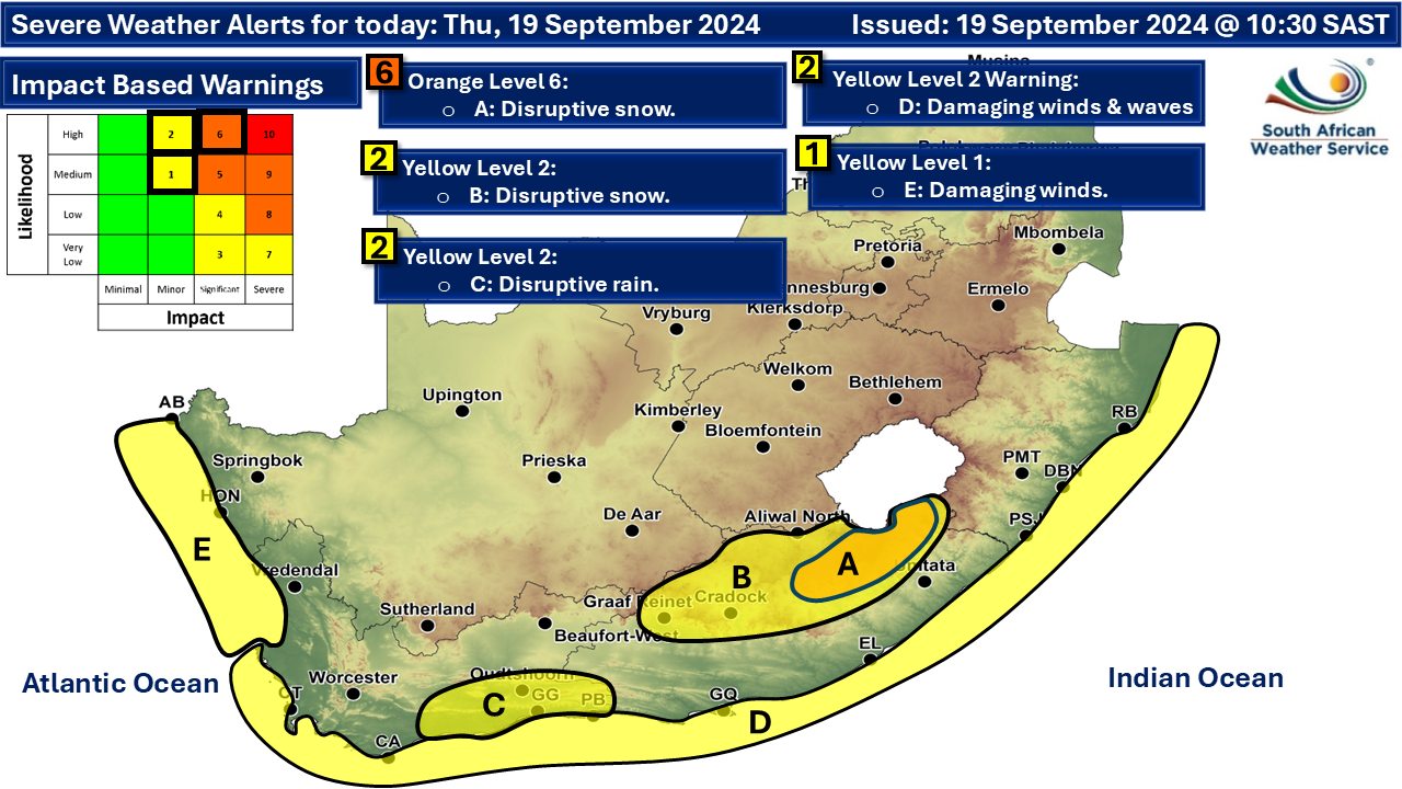
Warnings issued for disruptive snow – heavy snowfall for the Free State, Eastern Cape and KZN16 September 2024 [updated 21 September]By Staff Writer
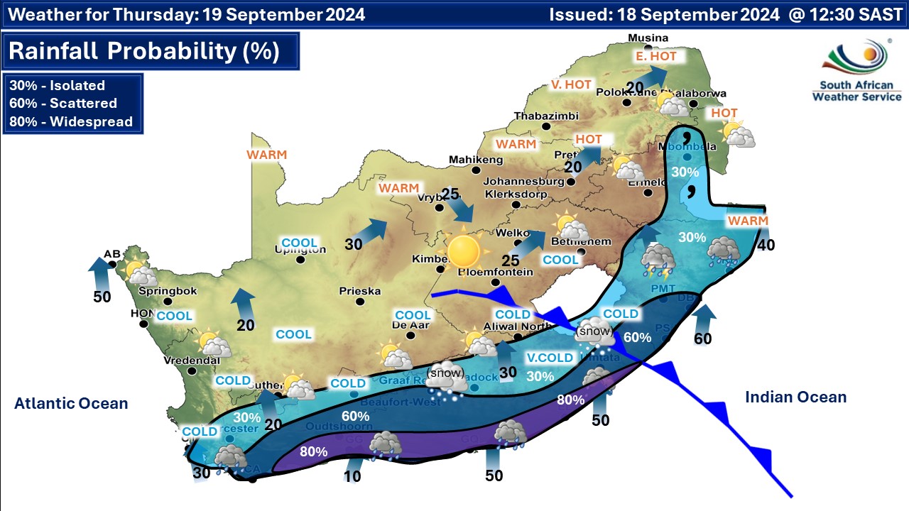
More detailed regional regional maps can be found below the forecast. Please note that this forecast will have more detail will be added regularly. Snowfall is indicated for most South African provinces, as well as Lesotho and Swaziland later this week and this includes heavy snowfall in some regions (marked in purple and blue on our map). In South Africa this includes the Western Cape, Northern Cape, Eastern Cape, Free State, KwaZulu-Natal, Mpumalanga and slightly into Gauteng and North West. The highest peaks in the Drakensberg might get up to 50cm and as much as 40cm is possible between Harrismith and Van Reenen. We've marked areas that may get 25cm or more of snow in blue on our map. Johannesburg was on the radar for a light dusting of snow but this has now changed. There is a chance of some light snowfall for Gauteng as per the map though. The SA Weather Service (SAWS) has issued snow-related warnings for Thursday, as per the map below. No warnings have been issued for Friday yet and we will post an update once they are. An orange level 8 warning for disruptive snow was issued at 8:09am on Saturday morning for Alfred Duma Ladysmith, Dr N. Dlamini-Zuma - Underberg, Greater Kokstad, Impendle, Inkosi, Langalibalele Escourt, Inkosi Langalibalele Sobabili, Mpofana Giants Castle, Mpofana, Mooi River, Okhahlamba, uMngeni from 1am on Saturday morning until 11pm on Saturday evening. Impacts include leading to icy roads resulting in major traffic disruptions, all mountain passes closed and widespread roads and railway lines temporarily affected due to accumulation of ice causing widespread traffic disruption. Travel should be avoided. A. orange level 6 warning for disruptive snow resulting in disruption to services and the temporary cut-off of communities is expected over the north-eastern high-ground of the Eastern Cape. D. yellow level 2 warning for disruptive snow resulting in icy roads and the closure of some mountain passes for a short period of time is expected over the northern and central high-ground of the Eastern Cape. While the snowfall will start from Thursday in places, the snow that will likely cause the most complicated driving conditions is currently indicated from late on Thursday and into Friday an possibly Saturday. Heavy snow is currently indicated to fall on parts of the N3 between Johannesburg and Durban from later in the day on Friday. Van Reenen, Newcastle, Vryheid, Mooi River, Rosetta, Nottingham Road in KwaZulu-Natal are all on the radar. Sani Pass is likely to get low-level snowfall, and the towns of Bergville, Himeville, Underberg, Franklin, Swartberg and Kokstad in the Southern Drakensberg region may also receive anything from a light dusting or flurries to much more significant snowfalls. Snowfall is currently indicated on the map across much of Mpumalanga including Graskop, Lydenburg, Dullstroom, Sabie, Secunda, Ermelo, Carolina, Lothair, Amersfoort, Volksrust, Standerton, Kriel. In the Free State areas such as Bloemfontein, Welkom, Steynsrus, Kroonstad, Senekal, Memel, Warden, Harrismith, Reitz, Petrus Steyn, Clarens, Bethlehem, Ladybrand, Thaba Nchu, Heilbron, Villiers, Reddersburg, Zastron and Trompsburg are all on the radar. Most of Lesotho is currently expected to get some snowfall, with the heavy snowfall indicated for a number of areas. Sani Pass is not going to be drivable according to current data and many roads across Lesotho are likely to be very challenging or completely closed. In the Eastern Cape the the usual areas that get snow are on the radar, including Nieu-Bethesda, Graaff-Reinet, Cradock, Somerset East, Molteno, Dordrecht, Barkly East and Hogsback, but areas such as Elliot, Ugie, Maclear and Matatiele are currently indicated to get fairly significant snowfall. At this point only light snowfall is indicated for the Western Cape peaks and the Swartberg range, as well as Sutherland and Fraserburg in the Northern Cape. Up to 45cm of snow is currently indicated for some areas such as the border between the Free State and KwaZulu-Natal, but mostly it will be under 10cm in most areas on the KZN side. ALSO READ: Be prepared for safe winter travel and snow chasing trips. ALSO READ: Cold front and cut-off low causing disruptive snow and other severe weather warnings for Thursday. The map indicates where we are seeing the possibility of snow, but it may not fall in all of the areas shown on the map. As with any forecast of any kind (temperature, clouds, rain, wind), what eventually happens may or may not be similar to the forecast. Please be sure to send photos and videos to us via whatsapp and also tell us where and when they were taken. See below for a link to our whatsapp channel but since the link does not work in the instagram app you will need to send us a whatsapp message and we'll send you a link. Follow our channels
Standard users are welcome to use the standard sharing buttons on this page to share our content. It is NOT acceptable to download or screen grab for reposting. Other media and channels need to send us a request in order to embed or use of our forecasts, maps, as well as images and video from our users that we post (before doing so).
Issued on Wednesday
       |