
 More weather maps below the forecast
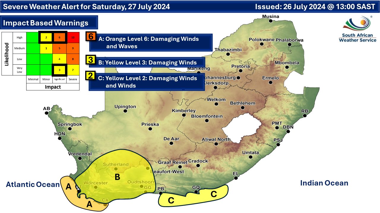
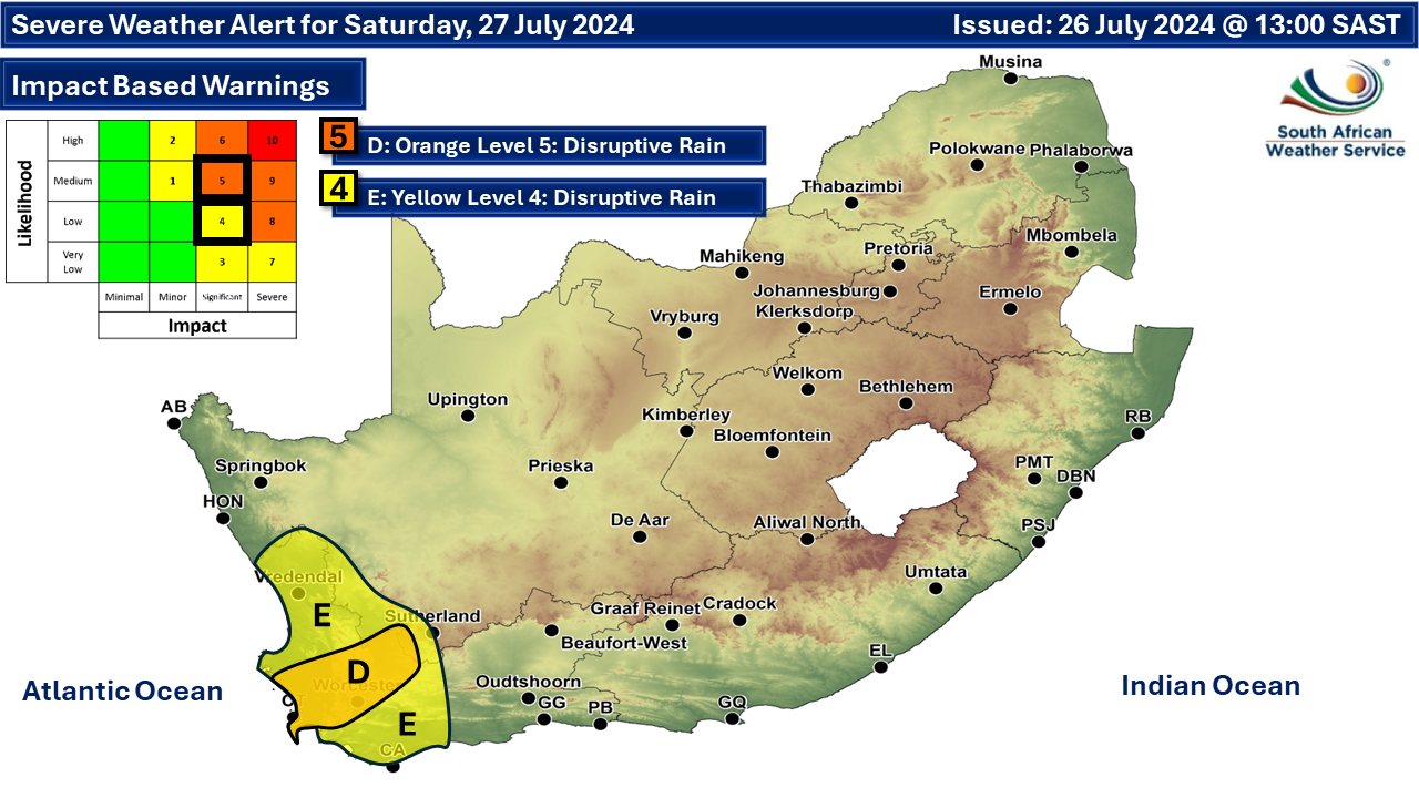
Damaging winds, waves and some snowfall again for Sunday22 July 2024 [updated 27 July]By Staff Writer
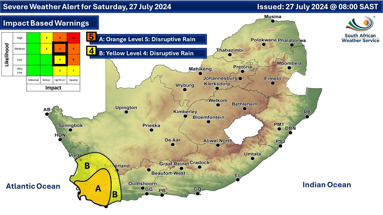
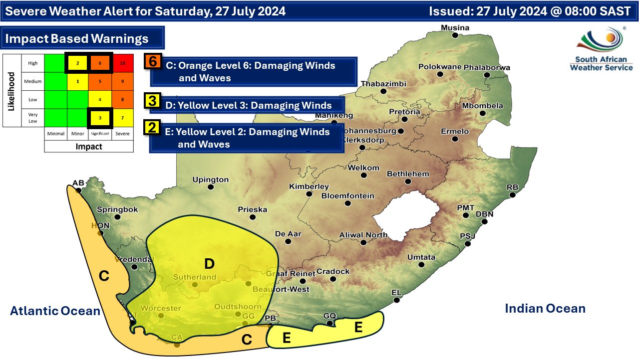
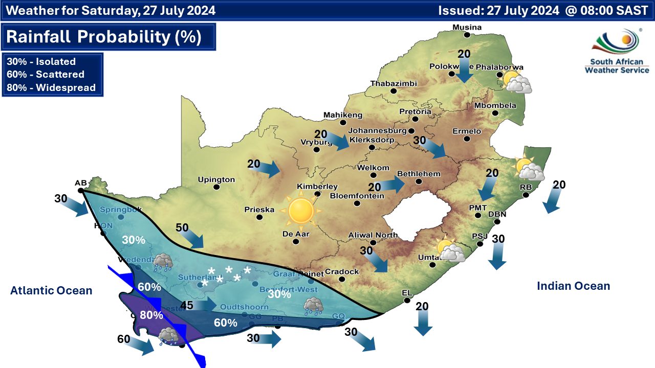
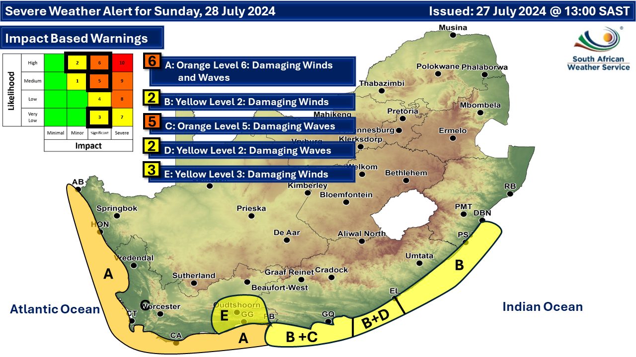
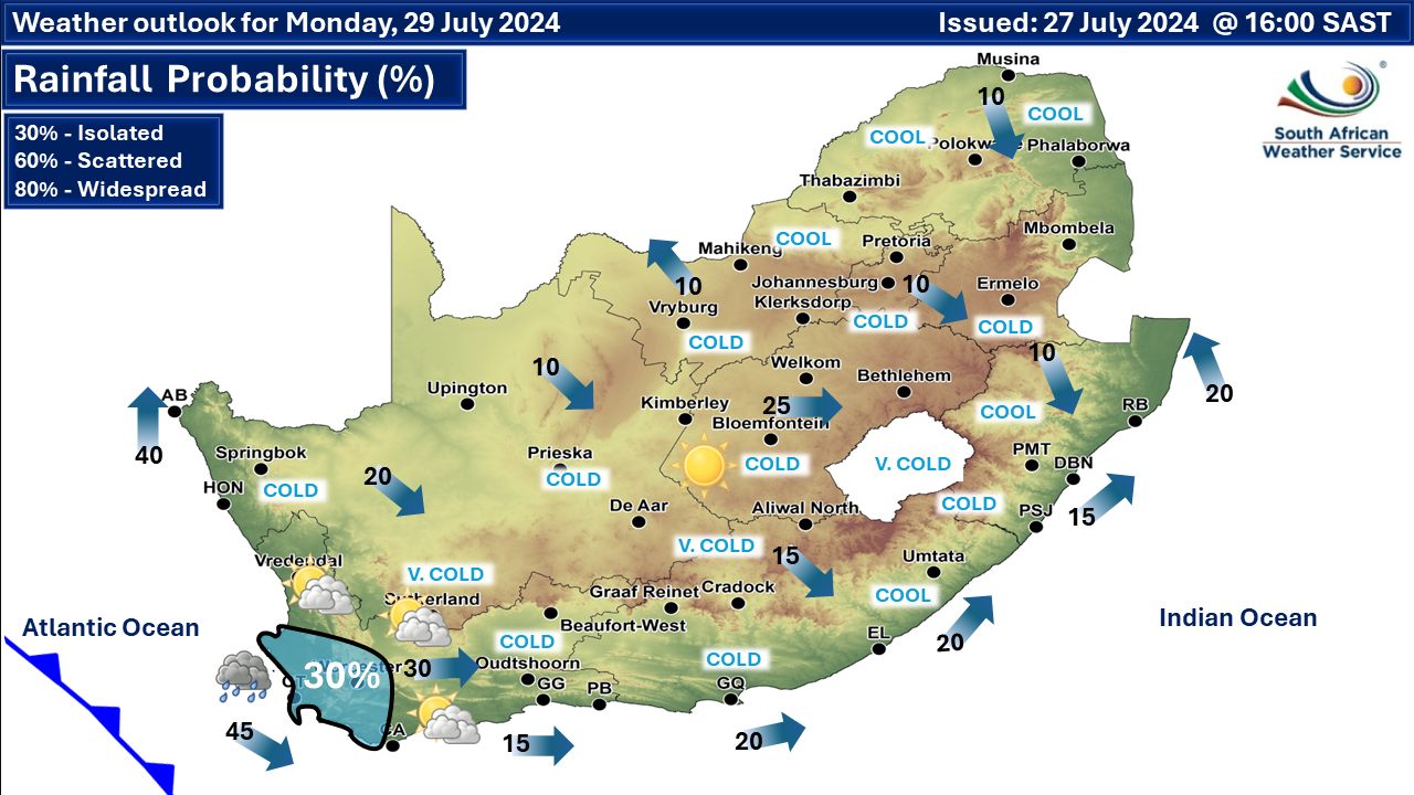
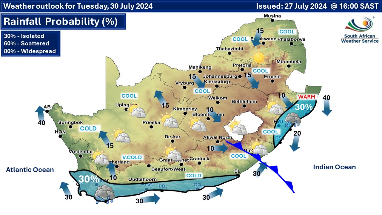
There is no podcast today as we are on a snow reporting trip. A newer weather forecast can be found here. More flooding is possible this weekend as level 4 and 5 disruptive rainfall warnings have been issued by the South African Weather Service (SAWS) and we have updated our forecast for low-level snowfall across a few provinces. According to SAWS, an intense cold front is expected to make landfall over the south-western parts of the Western Cape on Saturday morning, bringing rain and showers across the province during the day. The cold front that is expected to affect the Western, Eastern and Northern Cape from Saturday until Monday. The public and small stock farmers are advised about the expected intermittent heavy downpours, snowfalls, very cold conditions, strong coastal and interior winds as well as very rough seas. The fresh episode of rain and scattered to widespread showers over the Western Cape will certainly exacerbate the current conditions of waterlogged and flooded ground. An average of 10-20mm of rainfall can be expected over the southern parts of the country, reaching 30-50 mm in the mountainous areas of the Western Cape. Moreover, temperatures over the southern parts of the country are expected to plummet, with daytime temperatures not likely to exceed 10°C, particularly on Sunday. Very windy conditions are expected over the interior of the Western Cape and the southern parts of the Northern Cape. Westerly to north-westerly winds of 50-80 km/h, gusting to 80-90 km/h may result in significant wind damage-related impacts on Saturday. As the cold front passes, the sea state is expected to be very rough and choppy, resulting in difficulty in navigation at sea during the weekend through to Monday morning. High energy waves, with wave heights of 4-6m and wave periods of 12-16 seconds along the coastline from Alexander Bay to Plettenberg Bay, can be expected during this period. Wave heights are expected to reach 8m between Lambert’s Bay and Plettenberg Bay on Saturday and Sunday. Near-gale to strong-gale force winds are expected to accompany these south-westerly swells between Cape Columbine and Cape Agulhas on Saturday, spreading to Plettenberg Bay by Sunday morning while moderating from the west. Weather warnings from SAWS from Sunday: A. orange level 6 warning for damaging wind and waves leading to difficulty in navigation at sea is expected between Alexander Bay and Plettenberg Bay. B. yellow level 2 warning for damaging winds leading to difficulty in navigation at sea is expected between Plettenberg Bay and Durban. C. orange level 5 warning for damaging waves resulting damage to coastal infrastructure with a risk of medium to large vessels dragging anchor and breaking mooring lines is expected between Plettenberg Bay and Cannon Rocks. D. yellow level 2 warning for damaging waves leading to vessels being at risk of taking on water and capsizing within a locality as well as difficulty in navigation is expected between Cannon Rocks and Port Edward in the afternoon and persisting into Monday. E. yellow level 3 warning for damaging interior winds leading to possible difficult driving conditions, especially over major routes is expected over the eastern parts of the south coast of Western Cape. Extremely high fire danger conditions are expected in places over the northern parts of Limpopo. See the updated SAWS maps for warning coverage below. ALSO READ: More low-level snowfall on the way this weekend. Regional forecasts from SAWS for Sunday: GAUTENG Fine and cool but cold in the south. The expected UVB sunburn index: High MPUMALANGA Fine and cool but warm in the Lowveld. LIMPOPO Fine and warm but hot in places on the Lowveld and Limpopo Valley. THE NORTH-WEST PROVINCE Fine and cool to cold. THE FREE STATE Fine, windy and cold but partly cloudy in the south with isolated showers. THE NORTHERN CAPE Partly cloudy in the north-east, otherwise cloudy, windy and cold to very cold with a chance of light rain in the west and southern parts. Snowfall can be expected in the southern parts from the evening. The wind along the coast will be moderate to fresh northerly to north-westerly. THE WESTERN CAPE Cloudy and cold to very cold with isolated rain and showers but scattered along the south-west and south coast. Light snowfalls are expected over the northern high ground in the morning. The wind along the coast will be fresh to strong south-westerly becoming moderate to fresh in the afternoon. The expected UVB sunburn index: Low THE WESTERN HALF OF THE EASTERN CAPE Cloudy, windy and cold with isolated showers, but scattered long the coast and adjacent interior. Light snowfalls can be expected over the high grounds. The wind along the coast will be strong to near gale force westerly. THE EASTERN HALF OF THE EASTERN CAPE Cloudy, windy and cold to cool with isolated morning showers, except in the east where it will be partly cloudy. Light snowfalls can be expected over the high-grounds. The wind along the coast will be strong south-westerly. KWAZULU-NATAL Fine and cool but warm in places in the north-east, becoming partly cloudy to cloudy in the east and south by the afternoon with isolated showers and light rain, except in places in the north and north-west. The wind along the coast will be moderate to fresh northerly to north-westerly north of richards bay, otherwise moderate to fresh south-westerly, spreading northwards by late morning. The expected UVB sunburn index: High Travellers forecast from SAWS for Sunday: PRETORIA Fine. Minimum/Maximum: 03/20°C The expected UVB Sunburn Index: High JOHANNESBURG Fine. Minimum/Maximum: 02/18°C VEREENIGING Morning frost, otherwise fine. Minimum/Maximum: 01/17°C MBOMBELA Fine. Minimum/Maximum: 11/26°C POLOKWANE Fine. Minimum/Maximum: 07/25°C MAHIKENG Fine. Minimum/Maximum: 00/19°C VRYBURG Fine. Minimum/Maximum: -3/18°C BLOEMFONTEIN Partly cloudy. Minimum/Maximum: -3/11°C KIMBERLEY Fine and windy. Minimum/Maximum: 00/12°C UPINGTON Fine and windy. Minimum/Maximum: 01/14°C CAPE TOWN Cloudy with scattered showers and rain. Wind: moderate to fresh south-westerly. Minimum/Maximum: 09/13°C The expected UVB Sunburn Index: Low GEORGE Cloudy with scattered showers and rain. Wind: fresh to strong westerly. Minimum/Maximum: 08/13°C GQEBERHA Cloudy with scattered showers and rain. Wind: Strong to near gale force westerly. Minimum/Maximum: 08/15°C EAST LONDON Cloudy with isolated light morning showers, becoming partly cloudy Wind: Strong westerly. Minimum/Maximum: 10/17°C DURBAN Fine, becoming cloudy late morning with isolated afternoon showers and rain. Wind: moderate to fresh northerly to north-westerly in the morning, otherwise moderate to fresh south-westerly. Minimum/Maximum: 13/21°C The expected UVB Sunburn Index: High RICHARDS BAY Fine, becoming cloudy late morning with isolated afternoon showers and rain. Wind: Moderate to fresh southerly to south-westerly. Minimum/Maximum: 14/25°C PIETERMARITZBURG Partly cloudy with isolated showers and rain. Minimum/Maximum: 04/19°C See the South African Weather Service maps below. This forecast changes regularly and updates will be issued periodically. Please be sure to send photos and videos to us via whatsapp and also tell us where and when they were taken. See below for a link to our whatsapp channel but since the link does not work in the instagram app you will need to send us a whatsapp message and we'll send you a link. Follow our channels
Standard users are welcome to use the standard sharing buttons on this page to share our content. It is NOT acceptable to download or screen grab for reposting. Other media and channels need to send us a request in order to embed or use of our forecasts, maps, as well as images and video from our users that we post (before doing so).
Issued on Saturday
       Issued on Friday
  |